West, Ian. 2012. Durlston Bay, Lower Purbeck Group (Lulworth Formation, part); Geology of the South Coast. Internet site: wessexcoastgeology.soton.ac.uk/Durlston-Bay-Lower-Purbeck.htm. Version: 16th October, 2012.

Faculty of Natural and Environmental Sciences,
Southampton University,
Website hosted by courtesy of iSolutions, Southampton University
Aerial photographs by courtesy of The Channel Coastal Observatory , Southampton.
Home and Contents
|Durlston Bay - Peveril Point, Upper Purbeck Group
|Durlston Bay, Middle Purbeck
Durlston Bay - Lower Purbeck (this webpage)
|Durlston Bay - Central Zigzag Part and Coast Erosion
|Durlston Head - Lower Purbeck Group & Portland Stone
|Durlston Bay - Bibliography
Purbeck Group Bibliography |
| Purbeck Palaeoenvironments |
|..... For more webpages go to:
List of Webpages
This is part of a series of webpages on Durlston Bay.
Durlston Bay - Peveril Point and Upper Purbecks
Durlston Bay - Middle Purbecks and Building Stones
Durlston Bay - Lower Purbeck
Durlston Bay - Central and Zizag Area
Durlston Head.
Durlston Bay - Bibliography and References
Purbeck Group - Bibliography and References
Introduction - Safety
Durlston Bay is an extremely interesting place, valuable both in scientific and educationally terms place. Like other Dorset coast sections it can present some natural risks. At times, it is rather more hazardous than most places on the Dorset coast. In 1975 a schoolboy was seriously injured by a rockfall at Swanage and the following year another was killed by a falling rock (Lee, 1992 ). It is particularly important not to go under the cliffs (except for the low parts) in wet weather or after heavy rain or when there is melting ice. There is a major risk of encountering falling rocks here in those conditions. Never loiter close to the cliffs or hammer or search under overhangs. Safety helmets are essential here and so too is sensible observation of the state of the cliffs to be sure that debris is not falling. Care must be taken before proceeding south of Peveril Point.
One of the main areas specifically to avoid when conditions are unsafe is south of the Cinder Bed Ledge in the northern part of the bay. Here the lower part of the cliff is vertical and there is loose debris above. Falling fragments achieve dangerously high velocities here. This is definately a place to avoid in late winter and early spring, particularly after or during heavy rainfall.


Safety Note - On the 30th October 2007 the area, to the south of the northern Cinder Bed Ledge was observed to be very dangerous from risk of rock fall! The cliff has been undercut at the Mammal Bed and has an open fissure has developed above. There have been minor falls and there is an obvious dribble of debris at the bottom of the cliff. It is clear that a major rock fall will take place sooner or later!
Although the section is best studied at low tide, the tidal range is not great and unlikely to cause a major problem. You may, however, be obstructed at high tide at the north Cinder Bed Ledge. If cut off south of it ascend by the Zigzag Path. Ascent of the cliffs is dangerous except where there is a well-defined path and do not try cliff climbing. At low tide beware of slipping on slimy rocks and injuring yourself (be careful on the Upper Building Stones north of the Cinder Bed Ledge).
Note that the ledges near Durlston Head may be swept by waves and rock climbers using ledges in this region have been drowned.
If the conditions are bad or the bay seems unsafe try an alternative and safer location.
PURBECK FORMATION
Introduction - Isopach Map


.
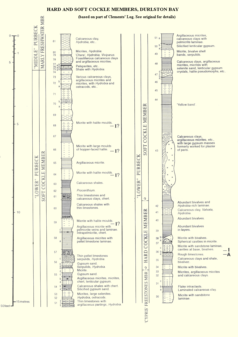
Soft Cockle Member

The Soft Cockle Member contains the small euryhaline bivalve Protocardia purbeckensis and consists of softer marls than the Hard Cockle Member. It is notable for containing secondary gypsum after anhydrite after primary gypsum. Sabkha facies and sabkha cycles are common and much of the gypsum is nodular. Insect remains occur at various horizons and small separate stromatolites occur in this unit on Portland and in the Lulworth area (House, 1968). Thin stromatolitic developments can be found in Durlston Bay, but are not obvious or abundant. More conspicuous are cream-coloured lacustrine dolomite beds with pseudomorphs after halite which occur in the upper part of the Soft Cockle Member. There is some celestite replacing calcium sulphate evaporites. Serpula coacervata from which the German Serpulite takes its name, occurs commonly in the Soft Cockle Member.
The micrites with pseudomorphs after halite (DB 64, DB 66 etc) are the main dolomites, and these usually contain palygorskite. This magnesium-rich clay mineral is common in arid and semi-arid regions. It occurs, for example, in the fine sediments of the desiccated salt-lake of Dukhan in Qatar in the Arabian Gulf and in many other modern evaporitic environments. The Soft Cockle dolomites originated in a lake but there is no significant blown sand and no indication of the proximity of a desert. A better modern analogue would be semi-arid and not truely arid.


This gypsum was once worked here for heating in a kiln to make plaster of paris. At the present time there is mining of Purbeck gypsum at Brightling in Sussex and formerly at the nearby Mountfield Mine ( he evaporite horizon used there is the equivalent of the Broken Beds, not of the Soft Cockle gypsum). The Soft Cockle gypsum has sometimes been referred to in old publications as consisting of masses of gypsum. Of course it is present underground, as beds not as "masses", but patchy dissolution near the cliff face has produced the appearance of irregular masses! At any significant depth it will be anhydrite not gypsum. The hydration and dissolution undoubtedly contribute to the instability of the Durlston Bay cliffs.

Petrographically the Soft Cockle gypsum is secondary, after burial anhydrite, which in turn was a replacement of primary lenticular gypsum (see the diagram above). Relics of the anhydrite crystals are easily seen under the polarising microscope in the modern secondary gypsum crystals.
Pseudomorphs after lenticular gypsum demonstrate the primary fabric. Authigenic quartz, the lutecite variety of chalcedony and some celestite are associated. Chicken-wire and nodular structure is well-developed. This is the result of the primary gypsum having undergone an early sabha phase, or "sabkhaisation".

The above diagram showing the postulated history of development of calcium sulphate nodules in the Purbeck strata is from West (1965).
Hard Cockle Member
The Hard Cockle Member in the Lulworth area consists of sandy bivalve limestone and are relatively hard. The molluscs were mainly Protocardia purbeckensis, a small cockle shell, hence the name. There is evidence of evaporites scattered through these beds, particularly pseudomorphs after halite. At the type section here, in Durlston Bay, the Hard Cockle Member consists not of limestones but of marls and marlstones. This is the "basinal" facies of the Purbeck Group. Protocardia purbeckensis is common. There are fossil insects in some beds, including solitary wasps occur at DB 36c (Rasnitsyn, Jarzembowski and Ross, 1998). There are no freshwater fossils or normal marine faunas and hypersaline lagoonal conditions were dominant (Rasnitsyn, Jarzembowski and Ross, 1998).
.
"Cypris" Freestones Member

This consists predominantly of ripple-lamined ostracodal and pelletoidal limestones. It mostly originated in water of about twice sea-water salinity (West, 1975). In the dry summers (the climate was very seasonal) the lagoon sometimes partially dried up leaving halite crystals in the fine carbonate sand flats. These were later dissolved away and filled with sediment so that now natural casts are preserved.

The isopod ("sea-slater") Archaeoniscus brodiei occurs at certain horizons. A conspicuous 1.3 metre marlstone, the Archaeoniscus Bed (DB 11), lies above the Broken Beds and is easily seen at Durlston Head. Archaeoniscus was recorded in this by Fisher (1856) and it also occurs in the overlying shales.
Dragonfly larvae are uncommon features of this member (Jarzembowki and Coram, 1997).
.
Broken Beds Member

The Broken Beds were formerly visible in Durlston Bay at two localities; just north of the Zizag Path and at Durlston Head. The northern locality formerly showed the ostracodal and pelletoidal limestone facies of the Upper Broken Beds. There are brecciated, thin-bedded limestones similar to those of the "Cypris" Freestone Member. The lower and main part of the Broken Beds at Durlston Bay consist of calcitised evaporites, often very porous and with some celestite, an insoluble residue of evaporite diagenesis. This evaporitic part was not seen in the northern exposure, being below beach level and cut off by a fault. The sea defences which have been built to protect the block of flats on the cliff edge have obscured the Broken Bed exposure in the north of the bay
In the southern part of the bay there are good exposures at Durlston Head and just to the north of the head. It is necessary to know the correct footpath to get access to the beach here (and it could dangerous to take the wrong one), unless one undertakes a long walk over the boulders of the shore from the Zizag Path. The location which has to be reached is just north of the normal fault downthrowing the Purbecks against the Portland Stone and clearly shown on the right hand side of the photograph here. The footpath is a hundred metres or so to the right (north) of this; you are warned that it can be a short rough scramble or climb which varies because of cliff collapse, and can be accessed from north of the Great Globe. Another longer path from a bridge further north is sometimes possible, but access on either is not easy and not recommended for a large party.
At the foot of the cliffs, close to the faulting (which is obvious) there is an interesting structure. The evaporitic basal Purbeck strata have been squeezed down in a "downbulge" and displaced northward to some extent resulting in an increased thickness of Broken Beds near the Jagged Rock (easily recognised). This is an important exposure of Purbeck evaporitic strata.
For more information on the basal Purbeck strata of Durlston Head please go to:
Durlston Head webpage.
.
Caps Member (Basal Purbeck Group)
The Caps at Durlston Head are mostly evaporitic, but have some stromatolitic limestone at the base. The Great Dirt Bed is missing and no tree remains have been found. The Lower Celestite Bed is part of the Caps. The diagram above gives the succession. For more detail see West (1960), Salter and West (1965) and West (1975).
For more information on the basal Purbeck strata of Durlston Head please go to:
Durlston Head webpage.
.
Coastal Defences - Durlston Bay

In the 1960s a block of flats was built in a very conspicuous position, close to the cliff top. They were placed above the middle of Durlston Bay, just north of the major faults and near the site of Beckles Mammal Pit. The geological situation of this locality can be quite well understood by considering the proximity to the cliff, the relationship to the strata, the relationship to the structures, and also, incidently, by referring to the old account of the Mammal Pit. At the foot of the cliffs are the Lower Purbeck marls and limestones containing interesting evaporitic beds with gypsum. This mineral was once quarried here, although some has been lost in solution, leaving some residue of celestite.

Unfortunately, in due course, the flats became threatened by coast erosion and cliff collapse. After some dispute about the problem of obscuring part of the classic type section of the Purbeck Group, some major coastal defences were built and they form the conspicuous white scar seen in the image. Presumably, they have now stabilised the flats and solved the problems facing the building. The defences, however, consist of large blocks of white Portland Stone contrasting with the grey marls of the Lower Purbeck Group. Although, part of the Purbecks remains obscured, perhaps eventually the scar may become less obvious when the stone weathers and becomes partially vegetated. This may be a long time, though, since Portland stone tips (weares) on the Isle of Portland have undergone little change in more than a hundred years. (Students may find this an interesting environmental geology problem to discuss, and the foot of the defences provides an opportunity to see Portland Stone.)
Acknowledgements
I am very grateful to Dr Clive Boulter for use of photographs taken from the Waverley. I am very much obliged to the Director and Staff of the The Channel Coastal Observatory , National Oceanography Centre, Southampton, for permission to use their aerial photographs.
Associated Webpages
Durlston Bay - Peveril Point and Upper Purbecks
Durlston Bay - Middle Purbecks and Building Stones
Durlston Bay - Lower Purbeck
Durlston Bay - Central and Zizag Area
Durlston Head.
Durlston Bay - Bibliography and References
Purbeck Group - Bibliography and References
Purbeck Dinosaur and Other Vertebrates Bibliography
|Home and Contents
|Last Week's Visitors|
Copyright
© 2010 Ian West, Catherine West, Tonya West and Joanna Bentley. All rights reserved. This is a purely academic website and images and text may not be copied for publication or for use on other webpages or for any commercial activity. A reasonable number of images and some text may be used for non-commercial academic purposes, including field trip handouts, lectures, student projects, dissertations etc, providing source is acknowledged.
Disclaimer:
Geological fieldwork involves some level of risk, which can be reduced by knowledge, experience and appropriate safety precautions. Persons undertaking field work should assess the risk, as far as possible, in accordance with weather, conditions on the day and the type of persons involved. In providing field guides on the Internet no person is advised here to undertake geological field work in any way that might involve them in unreasonable risk from cliffs, ledges, rocks, sea or other causes. Not all places need be visited and the descriptions and photographs here can be used as an alternative to visiting. Individuals and leaders should take appropriate safety precautions, and in bad conditions be prepared to cancell part or all of the field trip if necessary. Permission should be sought for entry into private land and no damage should take place. Attention should be paid to weather warnings, local warnings and danger signs. No liability for death, injury, damage to, or loss of property in connection with a field trip is accepted by providing these websites of geological information. Discussion of geological and geomorphological features, coast erosion, coastal retreat, storm surges etc are given here for academic and educational purposes only. They are not intended for assessment of risk to property or to life. No liability is accepted if this website is used beyond its academic purposes in attempting to determine measures of risk to life or property.

Webpage - written and produced by:
Ian West, M.Sc. Ph.D. F.G.S.
.
at his private address, Romsey, Hampshire, kindly supported by Southampton University, and web-hosted by courtesy of iSolutions of Southampton University. The website is an unfunded, private activity, and does not necessarily represent the views of Southampton University. Field trips shown in photographs do not necessarily have any connection with Southampton University and may have been private or have been run by various organisations.
.