
by: Ian West
|Home and Contents |Lyme Regis Town |Stonebarrow and East of Charmouth |Lyme Regis - West, Chippel Bay etc. |Lyme Regis - East, to Charmouth |Lias Fossils |Lyme Regis Bibliography| |Bridport, West Bay Field Guide | |Bridport Sands, East Cliff, West Bay Field Guide |
Click here for the full LIST OF WEBPAGES


Three Tiers
Three Tiers - boulders


Golden Cap is the highest cliff on the south coast of England and easily reached from the small coastal hamlet of Seatown, near Chideock, Dorset (on the Bridport to Lyme Regis road). It has a yellow capping of weathered Upper Greensand (Albian - Cretaceous) over Lower Jurassic Liassic clays. It is interesting to note that originally it was more golden but there has been a major increase in vegetation growth in recent years. You can see this by comparing the top two photographs above. Thus, like many of the Dorset chalk cliffs it is now much more vegetated than in the past. It is not known whether the vegetation increase is because of a reduction in the rate of coast erosion, or whether it is the result of global warming.
Golden Cap, Wessex - p. 31-33 in: The Marches of Wessex, by F.J.H. Darton, 1922.
"The crows and choughs that wing the midway air
Or if it can be heard, on this cliff by comparison with which Shakespeare's would be a paltry ledge, the sound is but the caress of a kindly mother visiting your sleep; a wistful charity in which any man might find peace. What is man in that superb isolation?
It is always of long-established peace, to me, that Golden Cap whispers. So high, so far, so lonely, you cannot be in the world. Why, the very gulls and daws that are floating below you are yet five hundred feet above land.
The sea itself could not rage here: the huge arc of cliffs holds out arms to calm it. Portland is not rock now: it is but a grey shadow. West Bay piers look the toys that in truth they are. And inland there is only a glowing ember of the earth's old fires: one of those flushing forests of the fire that hold shepherds and sheep and trees and all pastoral delights. The smooth roundness of Langdon Hill is red with heather and warm with golden gorse: the dark firs are unburnt coal: and there are (or once there were) shining flecks of cold ash-white rabbits at large upon the green and purple: and dead gorse standing for calcined coal. Far off there brood two great beasts, the slow ruminant backs of the Cow and her Calf, as sailors used to name the shapes of Pilsdon and Lewsdon Hills.
But if you go westwards a little you come back to geology, and in its most romantic form. On Golden Cap you have for a moment been on chalk. Then a little way down you are on the Middle Lias, and then on the Lower Lias. You are in the land of dragons. And the cliffs and the shore are full of dead bodies: fossils of all kinds..."
 "There is one other place in Dorset where the Earth's own past obtrudes itself, in a great view, upon one's thoughts about man's past and present. That is the summit of the highest cliff between the Wash and Land's End, Golden Cap. That glorious hill is known and loved by all Dorset men. It stands up with a peculiar boldness: a piled-up sloping mass, and then a bare stretch of yellow earth, crowned with a dark brown plateau. It can be seen from many a Dorset height; from Blackdown, from Pilsdon, from Hooke, even from great Bulbarrow himself, thirty miles away: always it is the same - a straight flat line cutting the sky proudly, and a golden edge sloping steeply down. The ascent of Golden Cap is a noble walk from Bridport or from Lyme, or in the journey from one to the other: though if you go the whole way-nine miles or so - you have to climb Charmouth Hill (500 feet), Stonebarrow Hill (500 feet), Golden Cap (619 feet), and Thorncombe Beacon (500 feet) - and descend to sea-level between each. Moreover, the last hundred feet up the Cap, whichever way you choose, is the worst stretch. It grows steepest there, and in summer the face of it is so slippery with desiccated grass, or so prickly with gorse, that the lost agility of Eolithic man would be a boon to-day. Beware also of rabbit snareswire nooses strongly pegged into the ground. If you come from the east shun the lower undercliff, which looks less arduous at first; here be quags and (in due season) serpents, as well as primroses and blackthorn and violets and blackberries.
When at last you come to the top, go across the plateau towards the south-west. Cast yourself down at the edge and dream. There are no history-lessons here: only a stillness, a poising of the soul, as of the body, over depths that bring the uttermost wonder of tranquillity. If you can bear it, look down :
"There is one other place in Dorset where the Earth's own past obtrudes itself, in a great view, upon one's thoughts about man's past and present. That is the summit of the highest cliff between the Wash and Land's End, Golden Cap. That glorious hill is known and loved by all Dorset men. It stands up with a peculiar boldness: a piled-up sloping mass, and then a bare stretch of yellow earth, crowned with a dark brown plateau. It can be seen from many a Dorset height; from Blackdown, from Pilsdon, from Hooke, even from great Bulbarrow himself, thirty miles away: always it is the same - a straight flat line cutting the sky proudly, and a golden edge sloping steeply down. The ascent of Golden Cap is a noble walk from Bridport or from Lyme, or in the journey from one to the other: though if you go the whole way-nine miles or so - you have to climb Charmouth Hill (500 feet), Stonebarrow Hill (500 feet), Golden Cap (619 feet), and Thorncombe Beacon (500 feet) - and descend to sea-level between each. Moreover, the last hundred feet up the Cap, whichever way you choose, is the worst stretch. It grows steepest there, and in summer the face of it is so slippery with desiccated grass, or so prickly with gorse, that the lost agility of Eolithic man would be a boon to-day. Beware also of rabbit snareswire nooses strongly pegged into the ground. If you come from the east shun the lower undercliff, which looks less arduous at first; here be quags and (in due season) serpents, as well as primroses and blackthorn and violets and blackberries.
When at last you come to the top, go across the plateau towards the south-west. Cast yourself down at the edge and dream. There are no history-lessons here: only a stillness, a poising of the soul, as of the body, over depths that bring the uttermost wonder of tranquillity. If you can bear it, look down :
Show scarce so gross as beetles. . .
The murmuring surge,
That on the unnumbered idle pebbles chafes,
Cannot be heard so high."
INTRODUCTION:
Access and Parking


To reach Seatown take the main Bridport - Lyme Regis road, the A35, to Chideock (map reference SY 422928). This village has one main street and from this turn south (seaward) into Duck Street (the small turning has a small signpost and is just west of the centre of the village). There is a large sign stating that the road is unsuitable for coaches and this is obviously the case. If you are in a car or minibus continue into the narrow Sea Hill Lane, which is mostly single track with passing places.
Drive cautiously south for about one kilometre to the sea front at Seatown (map reference SY 420917). Here there is a is a small private car park for cars and minibuses. The car park charge seems to vary but may cost about �1 or �2.50 and a little more for minibuses. This car park may be open only to 8 pm. Across a small stream is the Anchor Inn, where food and drink may be obtained, and this has some car parking space for use of customers while visiting the Inn. There is a shop associated with the caravan camp site a short distance up the road, and a small shop open near the beach may be open.
The beach is privately owned but is open to the public. There is the restriction that no dogs are allowed on the beach. The beach is quiet and pleasant, composed of small fairly rounded chert and flint pebbles, and with impressive views. It is possible to walk along the beach eastward to Eype, or westward to Golden Cap. There may be problems with falling cliffs or with tides and there needs to be attention to safety and risk matters (to be considered further below).
The cliff retreats and thus the cliff-top path to west has been diverted. It does not start at the Anchor Inn immediately above the cliffs. Instead proceed northward up the lane (back in the direction of Chideock) for a hundred metres or so, past Vanessa House of orange sandstone, past Seatown Farm House and you will notice a small path on the left of the road. This heads through a barley field over some stiles and up the slopes of Golden Cap. It is a very nice and impressive walk.

If the tide and sea-conditions favourable it might be possible to walk westward along the beach from Seatown to the cliffs of Golden Cap and then on to St. Gabriel's mouth. From there it may be feasible to ascend the cliff and return over the summit of Golden Cap. This is a very good walk but cannot always be recommended because there are certain hazards. It can be quite dangerous to proceed under the cliffs of Golden Cap at times, especially beneath the western buttress, a high vertical cliff of clay. In June 2004 had a "sword of Damocles" in the form of a large loose pillar of clay ready to fall. This is not a place at which to loiter and not a place for a large party. Beyond the cliff there is usually, but not necessarily always, access up to the cliff top at St. Gabriel's Mouth. Here there is sometimes an easy ladder and steps, as shown above, but the clay is being eroded so in June 2004 they were at the brink and in part over fissures. Unfortunately, they may soon fall. There is no other easy access to the cliff top around here, although it might be possible to scramble over the clay up the stream valley, although this is not recommended. If access up is impossible here then it would be necessary either to return by the beach to Seatown or to proceed on to Charmouth, and that would entail a long walk back to Seatown (note that the car park usually closes at 8pm). Whatever you do, first check on the tides and weather and take great care to avoid dangerous parts of the cliffs. The conditions need to be assessed on the day, and alternatives borne in mind.
It is important for the user of the coast to make their own assessment of the risks at the time. These can be very different according to weather conditions and tides. For some general information please see the Safety webpage.
The main danger to geological visitors here is of falls of hard mudstone, clay, shale or sandstone from the cliffs. The clay cliffs around here are prone to falls at any time, but particularly during or after very wet weather, after frost and also (and less expected) in hot dry summer weather when the clay is liable tos shrink (there was a major cliff fall in June 2004 as reported on television). The dry-weather falls may not be large but are particularly dangerous because more people are likely to be on the beaches, and they may be less cautious in these conditions. Safety helmets should be worn and it is essential to look and see whether there is fresh fallen debris at the foot of the cliffs. If there is keep well away and particularly avoid the places where there have been falls recently. The beach on either side of Seatown is fairly wide and in normal sea conditions there is room enough to stay clear of the foot of the cliff.

The eastern base of Golden Cap has landslides and mudslides at the base and is not vertical. The western side (western buttress) of Golden Cap is much more dangerous. There are vertical cliffs of unstable clay and a small beach. It is not a place to loiter.
Beyond Golden Cap to St. Gabriel's Mouth the beach is sufficiently wide to avoid the foot of the cliffs and they are sloping to some extent. Although the hazard is less here, falls can still occur, though, and dry-weather falls are still a risk. The steps at St. Gabriel's Water were threatened by coast erosion when seen in June 2004.
The coastal cliff path west from Seatown is not close to the edge in most place so that the risk of falling from the cliffs is not high. Only at the summit of Golden Cap is there a high viewpoint which gives a feeling of mountain-like exposure. Obviously strict control of children would be needed here. You are not advised to climb the cliffs as there can be danger both from falling and from debris that might fall on you or might be dislodged by you so as to fall on others.
On the coast here as elsewhere there are risks from the sea, particularly in stormy conditions. Tides need to be checked if going to or past the foot of Golden Cap.
When studying the beach or Upper Greensand exposures do not, under any circumstances, hammer flints or chert as such brittle silica produces dangerous splinters.
Other less likely risks include those of adder bites. In winter field parties must be adequately dressed and should have warm and waterproof clothing with them.
STRATIGRAPHY:
Succession at Golden Cap and Seatown
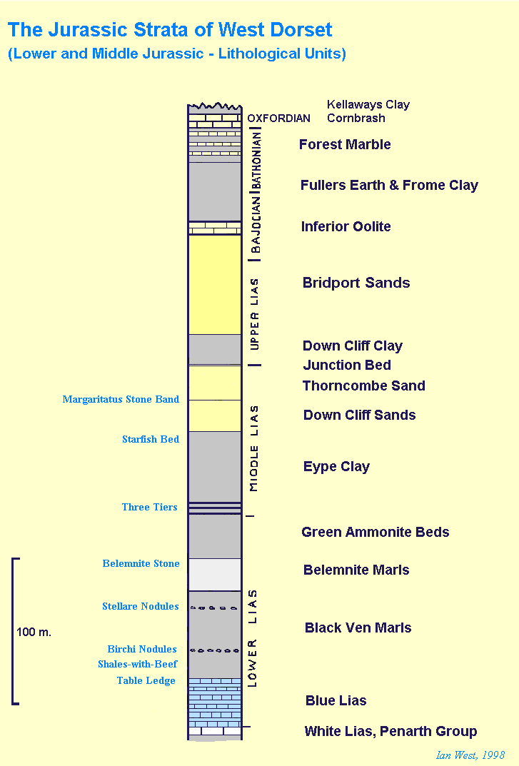

The section in the above left diagram is a simplified and introductory scheme to the lithological sequence of the Lower and Middle Jurassic strata. The right-hand diagram gives the traditional zonal scheme of the Lower Jurassic with lithological equivalents, based on House (1993) and Cope (1980).


The map above and the cliff-sections provide location information and the introductory geological setting for the area. The general pattern is that on the hill tops there is weathered Cretaceous Upper Greensand (producing the golden top to Golden Cap). The Cretaceous strata lies unconformably on grey Liassic (Lower Jurassic) marine clays with ammonites and belemnites. The clay and sand cliffs are very unstable and undergo landslides and rapid sea-erosion which reveals the fossils.


The uppermost part of the Belemnite Marls are present on the east side of Golden Cap. A syncline at the headland takes them down below beach level again. On the eastern side of Golden Cap the Belemnite Marls are under the beach and have been well-exposed on rare occasions when the beach has been cleared of shingle by the waves. In general the better exposures of the Belemnite Marls are west of St. Gabriel's Mouth at Westhay Water and in the cliffs beyond.


The Green Ammonite Beds are Lower Jurassic clays with ammonites and other marine fossils, and which reach a maximum of 34m on the coast. Lang, 1936 found that they are thickest, 34m at Golden Cap (Red Band to base - 17m and above Red Band - 17m) but are only about half this, 15m, at Stonebarrow, west of Fairly Dell (Red Band to base - 7m and above Red Band - 8m). They are mostly Lower Pliensbachian in terms of stage and belong for the most part to the Prodactylioceras davoei Zone. The uppermost three metres though are in the Upper Pliensbachian and in the Amaltheus margaritatus Zone (see also the Staithes webpage on strata of similar age). The upper boundary of the Green Ammonites Beds is marked by the siltstones of the Three Tiers. As shown in the photograph above, ammonites can be found in fallen material, with aragonitic shell material and in some cases with pyrite present. Androgynoceras lataecosta (J. de C. Sowerby) is the "Green Ammonite".
The history of the Green Ammonite Beds terminology and subdivision has been discussed by Wilson et al. (1958). The term 'Green Ammonite Beds' was first used by Day (1863) for some 5.5m of clays which lie above the Belemnite Stone, and which contain limestone nodules enclosing ammonites, known as the 'green ammonites' because greenish calcite often fills the septal chambers. Woodward (1893) later extended the term to cover all strata in the Dorset Lias lying between the Belemnite Stone and the massive calcareous sandstone bands known as the Three Tiers. The alternative name 'Wear Cliff Beds' was proposed by Woodward and Ussher (1911).
The first detailed subdivision was made by Lang (1913), the beds being redescribed and consecutively numbered [122-32] a year later (Lang 1914). Finally in 1936 the whole division was thoroughly investigated by Lang and others (Lang, 1936) and was found to correspond to the davoei Zone, with the basal part of the margaritatus Zone at the top [131-2].
We can consider the lithology of the Green Ammonite Beds in more detail. They mainly of rather blocky or massive clays, not cyclical shales, and with irregular carbonates (both limestone and siderite) present at three main horizons. Towards the top the beds become increasingly sandy until the uppermost 5.5m consist of sandy loam. The limestones are known respectively as the Lower Limestone, the Red Band and the Upper Limestone, and of these the most important is the Red Band, since it forms a conspicuous datum line. This presumably sideritic bed consists of a more or less continuous carbonate about 0.3m thick situated near the middle of the Green Ammonite Beds; its top and bottom weather a reddish colour but the centre is grey, so that it usually appears as two thin red carbonates separated by shale. The Lower Limestone, lying about midway between the Red Band and the Belemnite Stone, is a discontinuous band of small, hard limestone nodules. The Upper Limestone occurs about mid-way between the Red Band and the lowest of the Three Tiers; it is composed of two beds of shaly limestone separated by about a metre of blue-grey clay.
Wilson et al. (1958) were concerned with the problem of fixing the base of the Middle Lias, particularly for mapping purposes. The Green Ammonite Beds as defined above are mostly Lower Lias, but they include at the top part of the Middle Lias which has the ammonite genus Amaltheus . It was originally thought that Amaltheus did not range beneath the Three Tiers, but the discovery on the coast of A. stokesi in the 3.4m of loams underlying the Three Tiers (Lang, 1936) made it necessary to place the boundary between the Lower and Middle Lias below this horizon. On the coast Lang was drew this boundary above beds containing Oistoceras and below those containing Amaltheus. As Wilson et al. (1958) noted however, inland Oistoceras and Amaltheus have been found to occur side by side. A further difficulty is the fact that the Three Tiers are not recognizable inland. Traced northward sandy facies appear to be developed at lower stratigraphical levels in the Green Ammonite Beds, and Wilson et al. (1958)found it to be almost impossible inland to draw a line to define the top of the Green Ammonite Beds.

For older information on the fossil content of the Green Ammonite Beds see the paper of Lang (1936) and those with it of Spath on the ammonites, of Cox on gastropods and bivalves and of Muir-Wood on the brachiopoda. The ammonites are most famous but there are also interesting small gastropods and the unusual disc-shaped brachiopod - Discinisca. Numbers in the fossil list refer to Lang's bed numbers starting with 122a just above the belemnite stone (see diagram above). This older palaeontological information needs to be updated by reference to recent publications which will be available to the specialist (some more modern data will also be given here later, when time permits).
The Three Tiers are calcareous sandstones of marine origin, on average 0.6m in thickness (Wilson et al., 1958). They are separated by shale beds ranging from 1.5m to 4.6m thick. Overall the Three Tiers reach a maximum thickness of about 9m beneath Golden Cap, as shown in the photograph here, reducing to 4.6m on Stonebarrow Lang (1912). The Three Tiers have only been recognised with certainty on the coast; in places inland they may be represented by sandy doggers (nodules) according to Wilson et al. (1958).
The Three Tiers can be studied in situ in a deep gully below the summit of Golden Cap and in sections further southeast. You are warned that climbing on these clay cliffs can be dangerous though, especially because pieces of clay can fall at high velocity. Fallen blocks of the The Tiers are easily accessible in the boulder arcs at the foot of Golden Cap. Of the tiers, the bottom one is most fossiliferous and contains ammonites including Amaltheus and Tragophylloceras in addition to small gastropods. They are probably of relatively shallow marine origin.

The Eype Clay forms the middle part of Golden Cap above the Three Tiers. In general it is a blue-grey, micaceous marl or silt of rather similar appearance to the Green Ammonites Beds beneath the Tiers. The Eype Clay is about 60m thick at Golden Cap. Fossils are not abundant in the main mass of the marls but small specimens of Amaltheus can be found.
Above the Starfish Bed which marks the top of the Eype Clay come the Down Cliff Sands. These are not conspicuous yellow sands but argillaceous sands, once known as the Laminated Beds because of their appearance. They are about 23m in thickness but part is cut out by the unconformity in Golden Cap. They are grey and silty in the lower part and browner and more sandy towards the top. Nodules and occasional bands of calcareous sandstone are developed within them. Golden Cap has within it the westernmost exposure of the Down Cliff Sands, just under the Albian unconformity. These are high in the cliff, though, and probably more accessible at Thorncombe Beacon and in West Cliff, between Bridport Harbour (West Bay) and near Fault Corner and Eype.
Wilson et al. (1958) have provided some more detail about the Down Cliff Sands in Golden Cap. At a distance of 2.4 to 4.3 m (at different places on the Dorset coast) there is a layer of black marl, 20 cm thick, with ossicles of Isocrinus which have been replaced by iron oxide and appear deep red. Locally on Golden Cap at about 19m above the Starfish Bed there is a curious conglomerate bed with flat pebbles and rolled belemnites in clayey sand with some sandstone above and below. Presumably this is some type of beach deposit and indicates uplift or a fall in relative sea-level.
STRATIGRAPHY:
Cretaceous Strata

The Gault is the Cretaceous, blue, sandy clay unit lying unconformably above the Liassic strata. It is almost 15m thick in the centre of Golden Cap according to Wilson et al. (1958), but varies and less in other parts. These authors stated that the best section is on the spine-like buttress imediately south of the summit and is somewhat difficult of access. Apparently, if it is necessary to approach it this is best done from the eastern side according to those authors. It consists of the basal Gault pebble bed overlain by fossiliferous micaceous loams with some sand. The Gault is probably more sandy than is typical further east. The pebble bed is in general about 1.5m thick, but a thickness of 3.5m has been recorded in the past by Jukes-Brown (1900) on the southeastern face. Truncation of two pebble beds by penecontemporaneous erosion has been recorded by Wilson et al. (1958). The pebbles are small and mostly consist of vein quartz, chert, lydite, and quartz with tourmaline.
An older record of the details of the Gault of Golden Cap is given below, left:


Above this is the Upper Greensand (Albian), some fossils of which are shown above (right). This consists of about 30m of glauconitic sand with some sponge chert at the top in this Dorset coastal region. At Golden Cap there is mainly green glauconitic sand, mostly weathered at the surface into yellow-brown sands known as "Foxmould". This yellow- weathered greensand produces the feature of the Golden Cap. It does not extend quite to the summit because at the top there about 4m of slipped and broken Chert Beds, with some Quaternary cherty debris beneath the soil.
GEOMORPHOLOGY
Boulder Arcs of Golden Cap


As seen from the summit on a clear day, Golden Cap has impressive boulder arcs formed by former mudslides from the thick Liassic clay sequence of the Green Ammonite Beds and the Eype Clay. The boulders are mostly blocky, fine sandstones of the Three Tiers, the base of the Middle Lias. Clearly some quite large mudslides have flowed down the front of this headland. There are some inactive ones present now but in summer 2004 they are not soft and not a barrier to walking past Golden Cap (although take care - there is serious risk of falling clay!).
From the photographs you can see that some of the arcs are below sea-level at about mid-tide, but the eastern one has some blocks of Three Tier sandstone projecting, and these form convenient resting places for seagulls and other sea-birds.
References and bibiography of Seatown and Golden Cap are included within the Lyme Regis Geological Bibliography. Please go to this.
Copyright
© 2011 Ian West, Catherine West, Tonya West and Joanna Bentley. All rights reserved. This is a purely academic website and images and text may not be copied for publication or for use on other webpages or for any commercial activity. A reasonable number of images and some text may be used for non-commercial academic purposes, including field trip handouts, lectures, student projects, dissertations etc, providing source is acknowledged. No permission can be given for reproduction of any images of the Lulworth Cove area in books or in other websites, for special reasons.
Disclaimer:
Geological fieldwork involves some level of risk, which can be reduced by knowledge, experience and appropriate safety precautions. Persons undertaking field work should assess the risk, as far as possible, in accordance with weather, conditions on the day and the type of persons involved. In providing field guides on the Internet no person is advised here to undertake geological field work in any way that might involve them in unreasonable risk from cliffs, ledges, rocks, sea or other causes. Not all places need be visited and the descriptions and photographs here can be used as an alternative to visiting. Individuals and leaders should take appropriate safety precautions, and in bad conditions be prepared to cancell part or all of the field trip if necessary. Permission should be sought for entry into private land and no damage should take place. Attention should be paid to weather warnings, local warnings and danger signs. No liability for death, injury, damage to, or loss of property in connection with a field trip is accepted by providing these websites of geological information. Discussion of geological and geomorphological features, coast erosion, coastal retreat, storm surges etc are given here for academic and educational purposes only. They are not intended for assessment of risk to property or to life. No liability is accepted if this website is used beyond its academic purposes in attempting to determine measures of risk to life or property.

Webpage - written and produced by:
.
Ian West, M.Sc. Ph.D. F.G.S.