West, Ian M. 2019. Lyme Regis, Westward. Part of Geology of the Wessex Coast. (including part Jurassic Coast, Dorset and East Devon UNESCO World Heritage Site) Internet geological field guide. Update: Enlarged and revised at various dates including, 1st Ocrtober 2019.

by Ian West
Romsey, Hampshire, and:
Visiting Scientist at:
Faculty of Natural and Environmental Sciences
Southampton University,
with some field contributions, particularly on the Lyme-Regis-Axmouth landslide area by Dr. Ramues Gallois
Webpage hosted by courtesy of iSolutions, Southampton University
Website archived at the
British Library
Aerial photographs by courtesy of The Channel Coastal Observatory , National Oceanography Centre, Southampton.
|Home and List of Webpages
|Lyme Regis - Town and Seafront
|Lyme Regis - East, to Charmouth
|Lias Fossils
|Lyme Regis Bibliography|
|Beach Fires, Cliff Fires and the Lyme Volcano
Click for the full LIST OF WEBPAGES
Click or double-click on images for full-size high resolution versions! Avoid browser zoom.
(You can download this educational site to SurfOffline, WebCopier or similar software to keep a safe permanent offline copy, but note that at present there is periodic updating of the live version.)


Go to -
Lyme Regis - East, to Charmouth (with Black Ven)?
Liassic Fossils?
Lyme Regis - Bibliography?

CONTENTS
(under construction)
LYW1- INTRODUCTION - General
LYW2- INTROUCTION - Aerial Photographs
LYW3-
LYW4-
LYW5-
LYW6-
LYW7-
LYW8-
LYW9-
LYW10-
LYW11-
LYW12-
LYW13-
LYW14-
LYW15-
LYW16-
LYW17-
LYW18-
LYW19-
LYW20-
LYW21-
LYW22-
LYW23-
LYW24-
LYW25-
LYW26-
LYW27-
LYW28-
Lyme Regis is a small coastal town situated at the outcrop of very fossiliferous, marine, Lower Jurassic. It is famous for ichthyosaurs, plesiosaurs, a dinosaur, fossil collectors, a good museum, cement manufacture, landslides, Dean Buckland, and, of course, Mary Anning. In broader geological perspective Lyme Regis is at a location that until about 200 million years ago was in the centre of the great desert of Pangaea. The supercontinent collapsed and became flooded, initially with lagoons (Pinhay Bay), and then with the sea of the Blue Lias. This sea, about 1000km off Newfoundland, deepened progressively. Because there was high organic life and low clastic input, oil source rocks began to be deposited. It is the best place to see, in excellent cliff sections, the oil source rocks of the great Wessex and Weald Basin oilfields. The high organic content and extensive pre-compaction cementation are reasons for the famous fossil preservation. Onshore, the Lower Lias does not reach the Kimmeridge Clay, deeper oil source phase (Mg-rich and highly compacted), but the birchi nodules approach it. This website provides field information in detail and explains the geology of Lyme Regis from a university academic viewpoint. It is, however, a description of the geology and not a field trip itinerary.
LYW1 - INTRODUCTION
General

.


The maps above, and the general cliff sections, provide the introductory geological setting for the area and also location information. The website deals with Monmouth Bay (or Chippel Bay), Ware Cliffs, Pinhay Bay, Humble Point, Charton Bay, Culverhole Point etc.
The general pattern is that on the hill tops there is weathered Cretaceous Upper Greensand (brownish green) with much chert and with some Chalk (of about 100million years old). These units lie unconformably on grey Liassic (Lower Jurassic) marine clays (of about 190 million years old) with ammonites, belemnites and, occasionally, ichthyosaurs and plesiosaurs. The occurrence of the Cretaceous sands and chalk above Jurassic clays is the cause of much landsliding in the area. The clay cliffs undergo rapid sea-erosion which reveals the fossils. The details of the geology are discussed below.
See the report for West Dorset County Council on Ware Cliffs, and other reports on the area by Dr. Ramues Gallois. These reports are very thorough and detailed. They are available on CD roms.
LWY2 - INTRODUCTION:
Aerial Photographs - General
For aerial photographs of the Lyme Regis area go to:
The Channel Coastal Observatory , National Oceanography Centre, Southampton. There are numerous, orth-rectified aerial photographs taken at low tide on various occasions. They cover all the south coast of England and elsewhere and are of very high resolution. In addition there is much technical data, such as Lidar, available. First go to the online site above, then register with the CCO online. You can then download the aerial photographs and other coastal data that may be required.

The small-scale aerial photograph above shows Lyme Regis and the coast westward, through the Axmouth - Lyme Regis Undercliffs, National Nature Reserve, as far as Goat Island and Culverhole Point. This is just a copy of index photographs and not at high resolution. Detailed, large-scale aerial photographs can be downloaded free by registering with the
The Channel Coastal Observatory , National Oceanography Centre, Southampton.
INTRODUCTION - Historic Photographs - West of Lyme Regis
To see an excellent set of historic photographs of the Lyme Regis area, and in particular the landslides, east and west of Lyme Regis, go to the following:
Doreen Smith (2012 etc.) Dorset Historic Coastal Photographs. Exmouth to Milford on Sea 1800-2000 (including the East Devon and Dorset World Heritage Site). by Doreen Smith of the Dorset Group of the Geologists' Association. These pages grew out of an original project to celebrate 150 years of the Geologists' Association and 200 years of the Geological Society.
INTRODUCTION
Panoramic Photographs
For high resolution panoramic photographs of Lyme Regis see:
Panoramas of Lyme Regis - by Malcolm Etherington.

INTRODUCTION
UAV (Unmanned Aerial Vehicle) Studies
Go to the recent research on landslides west of Lyme Regis by Richard Edmonds See:
Edmonds, R. 2014. The use of UAV generated photo mosaic surveys for geological and geomorphological monitoring and mapping on the Jurassic coast. PDF file. By Richard Edmonds, Earth Science Manager, World
Heritage Site Team. Hosted by Dorset County Council, County Hall, Dorchester, DT1 1XJ.
This is the link for a PDF download of a presentation by Richard Edmonds:
Use of UAV generated photo mosaic survey for geomorphological mapping etc.
LMW - INTRODUCTION:
Car Parks for the Western Cliffs of Lyme Regis


Lyme Regis is in a valley where the small river runs out to sea. Coaches and car for field trips to the west can park at the large Holmbush car park up the hill on the west side of the town. The car park charge is cheaper here, being at present (2011) - One Pound, 70 pence per day. Cars can also park at Monmouth Beach car park near the Cob (and shown above), but the charge at present (2011) is One Pound per Hour here.
The centre of Lyme Regis has narrow roads and there is no parking in that area (go to Charmouth Road Carpark to the north, or Holmbush Car Park, mentioned above to the west). Large coaches cannot pass through the centre of the town with its narrow steet and a sharp turning, if they are coming in on the road from Charmouth. Large coaches should not take the usual A3052 (Dragon's Hill) road to Lyme Regis (suitable for cars) from the roundabout northwest of Charmouth. Instead, they should continue on the A35 until they can take the left turning onto the B3165 to Uplyme. From there they proceed to the Holmbush Car Park above the Cobb.
The field excursion described below is to the west of the small harbour - the Cobb. Usually there is access to the cliffs without major problems from the tide, but this may not be the case in stormy weather. Access to the coast eastward requires low tide. The Blue Lias is well exposed from Chippel Bay to Seven Rock Point and beyond.
Other parts of Lyme Regis are also well visiting.
In the town centre area there is an excellent museum and fossil shops. The central seafront area has been the site of civil engineering works. The Church Cliff section to the northwest of the town is a classic geological coastal exposure. These locations are shown in associated web pages.
For the geology of Lyme Regis central seafront and town see:
Lyme Regis Seafront webpage.
For the geology of Church Cliffs and Black Ven, northeast of Lyme Regis see:
Lyme Regis to Charmouth webpage.
LYW - INTRODUCTION
Access and Study for the Disabled
Monmouth Beach Car Park is accessible by car or minibus, but not coach. From here, on the flat, and at the same level the eastern part of Monmouth Beach is easily accessible (and so is the Cobb of Portland Stone). The beach may not be traversed westward very far by anyone with walking problems because of large boulders on the beach. However, go to the nearest part of Monmouth Beach, examine the far cliff with binoculars and use this website for details of the strata. You will receive both an impression of the location; you will see washed-up Blue Lias rocks on the beach, and by using the website photographs below you can study the detail. If possible and if the site is accessible go also along the promenade to its end at Church Cliff, east of Lyme Regis. There is no easy parking there though. If you can reach the place, it is possible with binoculars to see a good section of the upper part of the Blue Lias. Shore rocks and ledges can be seen at low tide. The website: Lyme Regis to Charmouth will provide photographs and details for further study. A visit to Lyme Regis Museum is recommended. It is quite feasible by these means to obtain some expertise on Lyme Regis geology without ever having to leave a level surface or scramble over rocks. It is also possible to drive to Charmouth and see something of the local geology from the car park and visitor centre.
LYW - INTRODUCTION:
Safety and Rock Fall Risk


The main hazard with regard to the cliffs west of Lyme Regis is that of being hit by falling rock. At the present (summer 2012) the stretch of eroding vertical cliff between the oblique fault (and the pressure ridge) and the Seven Rock Point sloping landslide (also a hazard) is particularly dangerous, especially in wet weather. The photograph above shows the location.
The chance of being hit by a falling rock is also a hazard at East Cliffs towards Black Ven on the other side of Lyme Regis, and elsewhere on this coast. Rock-fall risk to geologists in general may be less, statistically, than of drowning, but it is a significant hazard at almost any exposure anywhere. The experienced geologist does not look a the cliff so much as at the foot of the cliffs. Always, look for fresh fallen debris and minimise the time spent in recognised missile hazard zones. Look for the seaward limit of impact zones and try to keep seaward of them, it that is possible. By observation the risk is thus much reduced but never totally removed. The possibility of a cliff accident is never zero because cliffs are erosional features from which rocks fall. If there is no erosion and no falling rock the cliff will become a vegetated slope which is geologically useless.
Particularly in wet or after very wet weather, the cliffs present most risk from falling debris. Where there are active slip planes there can be a dribble of small material and the occasional fall of a larger block. Specific places on the beach where rock has recently been falling will show fresh fragments or piles of fresh debris. These places must be avoided. The autumn, winter and spring hazard is fairly obvious to anyone accustomed to studying cliffs. Less expected are dry-weather falls, but these are not uncommon. Drying out of the cliff can open up joints and fissures and cause sudden, falls that are sometimes quite major. Thus, there is considerable risk from these cliffs and, where possible, people should try to keep away from the foot of the cliffs. It is better, wherever possible, to study ledges out on the shore at low tide.
The accident topic is stressed here, because this is known hazard area. In 1924 when less regard was given to such matters, the Lias expert, Dr. W.D. Lang, wrote the following about the Lyme Regis cliffs of Blue Lias (p.175):
"A warning is necessary amongst these practical remarks. The cliff is constantly crumbling (larger falls are less frequent and never to be foreseen) and mud and stones continually pitch over the vertical face of the stone-beds making all loitering close beneath the cliff highly dangerous. Work actually at the cliff base is inevitably attended with risk. It is, however, easily seen that certain spots are temporarily more showered on than others, since the ledges are there splattered with mud and have loose fragments of chert etc., scattered about them; and these spots can be avoided. What is not realised is the great velocity acquired by a body pitching over a cliff-top so that even a small stone or lump of dried clay can cause serious casualty. The tides should also be observed. They are, however, more inconvenient than dangerous."
Beware of slipping on rocks or seaweed. Check the tides and take care so as not to be cut off by the tide. Be particularly careful in stormy weather.
Avoid climbing cliffs and rocks.
Leaders of field parties should make their own assessements of conditions on the day of the field trip and look for signs of recent cliff falls and for other hazards.
In the Axmouth-Lyme Regis Undercliffs there are some additional hazards. These are explained on notices, which should be read. Off the path there are fissures resulting from landsliding some of which are very deep, and these may be concealed by vegetation. In some places they almost resemble small crevasses on glaciers. Ticks are present in the undergrowth, and may attach themselves to people, especially if they are wearing shorts. These little creatures may seem to be merely a triviality but, in fact, should be avoided because they may be capable of transmitting Lyme Disease.
Note that not all places shown in the photographs of this webpage are accessible to the public and are not all places are necessarily safe or easily reached.
LYW - STRATIGRAPHY - BLUE LIAS OF LYME REGIS
.
LYW-STRATIGRAPHY
Introduction:
The Lower Jurassic System of West Dorset.

The simplified outcrop map above shows the distribution of Jurassic strata at the surface on the British land areas. The offshore outcrops, such as in the North Sea and the English Channel are not shown here. Jurassic also underlies extensive areas in southeastern England, as in the Weald of Kent and Sussex. Lyme Regis is shown at the southwestern end of the Yorkshire to Dorset outcrop.


A table above gives the chronostratigraphy of the Jurassic System in terms of stages originally with dates mainly from Odin as given in the International Stratigraphic Chart of UNESCO, 2000, but updated to those of Gradstein, Ogg and Smith (2004). It is is recommended that checks be made with regard to correction and updating from time to time. It is likely to be modified but mostly only to a small extent. The Jurassic/Cretaceous boundary presents special problems and there is some uncertainty here.
A section in another diagram is a simplified and introductory scheme to the lithological sequence of the Lower and Middle Jurassic strata. A third diagram gives the traditional zonal scheme of the Lower Jurassic with lithological equivalents, based on House (1993) and Cope et al.(1980) .
The Blue Lias is the unit mostly discussed here. This consists of thin alternating shales, marls and argillaceous limestones at the bottom of this Jurassic succession. The Blue Lias overlies "Rhaetic" strata (Penarth Group) which is a lagoonal facies of Upper Triassic age (and in turn overlies Triassic red-bed, desert facies). The Blue Lias represents the first normal marine sediments resulting from the transgression of the sea over the deserts and lagoons of parts of the great supercontinent Pagaea. The marine fauna increases upwards in abundance and diversity as the sea opens and deepens and then ammonites and ichthyosaurs and plesiosaurs live in the fairly warm water of moderate depth above the muddy sea-floor.
The Blue Lias is the lowest unit discussed here. This consists of thin alternating shales, marls and argillaceous limestones at the bottom of this Jurassic succession. The Blue Lias is 32m thick, and includes all the Hettangian Stage - Psiloceras planorbis, Alsatities liasicus, Schlotheimia angulata plus the lower part of Sinemurian Stage - Arietites bucklandi, Arnioceras semicostatum . These limestones and shales overlie " Rhaetic " strata (Penarth Group) which is a lagoonal facies of Upper Triassic age (and in turn overlies Triassic red-bed, desert facies). The Blue Lias represents the first normal marine sediments resulting from the transgression of the sea over the deserts and lagoons of parts of the great supercontinent Pagaea. The marine fauna increases upwards in abundance and diversity as the sea opens and deepens and then ammonites and ichthyosaurs and plesiosaurs live in the fairly warm water of moderate depth above the muddy sea-floor.
Marine mud facies of the Shales-with-Beef, an oil source-rock, and the Black Ven
Marls follow. The Shales with Beef are 25m thick and belong to the zone of Coenisites turneri . These are important fossiliferous units. The Belemnite Marls lie above.
STRATIGRAPHIC INTRODUCTION continued:
Jurassic Palaeogeography


A large map is provided above showing the position of the shelf seas of Europe in the Jurassic. Because this is a very generalised and not for a specific time in the period it should not be used as a precise marker of palaeolatitudes. It does indicate the area of extensional tectonics and basin development at the northeastern end of the Atlantic at that time. Not only was the formation of rifted basins responsible for much accumulation of clay, limestone and sandstone sequences of the Jurassic. In addition, the breakup of the old supercontinent Pangaea led to an increase in the number of spreading centres in the oceans (Lemon, 1993). This resulted in a consequent displacement of seawater from the oceans producing a rise in sea-level. Both the rifting and this process caused the transgression of Jurassic marine deposits over Permo-Triassic, desert red-beds.
Also above is a simplified palaeogeographic map showing the generalised distribution of sea and land in the British area during Early Jurassic times. The southern part of the Atlantic Ocean was opening to the southwest, but the North Atlantic was not open at this time. Shallow shelf seas with some locally deeper basins occupied much of the British region. This map is to set the scene in broad terms and the details varied at different times within the Early Jurassic. The southwest peninsula was probably the landmass from which the tree remains in the Lias of the Lyme Regis and Charmouth areas have come. There is uncertainty about whether Wales was completely submerged or whether there was land in the area. Because of a general later tendency for Britain to tilt eastward towards the North Sea basin, the London-Brabant (or London-Belgium) Uplands are now below sea-level and buried under younger sediments. As this area of Palaeozoic, hard-rock hills has gone down with the tilt so the Palaeozoic area of the Welsh mountains has come up in the west. The London-Brabant uplands are mostly at about 500m depth in the London area but rise to within 50m of sea-level in North Buckinghamshire.
The Lower Jurassic (Liassic) sea was continuous between the Dorset coast, where the strata are now very well-exposed, through the Midlands to the Yorkshire coast, which is also notable for excellent exposures. There are smaller Lower Jurassic outcrops elsewhere, particularly in South Wales and in northwest Scotland (Skye etc.)
STRATIGRAPHY-continued;
Graphic Log or Vertical Section of the Blue Lias
For the graphic log please go down to the Blue Lias Cliffs part of this webpage (the details are needed in close association with the photographs for interpretation)
LYW
INTRODUCTION AND LOCATION:
THE COBB TO MONMOUTH BEACH
Cobb to Monmouth Beach


Cobb Road is followed down to the Cobb, the harbour of Lyme Regis. It is a steep road because originally it was a cliff and a place not ideal for development. However, some housing has remained there in stable condition and other buildings have destroyed by land-slipping. Now the area has been largely stabilised by numerous piles and drainage schemes. This work has been completed and is largely concealed. See:
Lyme Regis Seafront webpage for details of this and of the Cobb.
LYW - LOCATION - MONMOUTH BEACH
Site of the Old Cement Factory and Car Park Areas
The brief comments here on the car park and hut area of Monmouth Beach are given as introduction to the geology of the natural stretch beyond.
For more on the developed part of Monmouth Beach, including some history, - please see the webpage:
Lyme Regis Seafront


Introduction
Monmouth Beach commences at the western side of the Cobb at Lyme Regis and extends westward into Chippel Bay. The large area of pebble, partly left as a beach and partly tarmaced is an artificial area of expanded beach accumulation held back by the western wall of the Cobb. The Cobb Wall is crucial in the survival of the Monmouth Beach developed area. The Cobb western wall is very robust and well-constructed. Nevertheless it has a history of having been periodically badly damaged and broken by great storms and then subsequently repaired. If it is destroyed by a hurricane the pebbles and boulders can be driven eastward by storms into the Cobb harbour, and thus reducing if not destroying Monmouth Beach.
The main beach, seaward, appears to be in relatively natural conditions, even though it is really an artificial accumulation against a groyne. The flat expanded area behind has been partially developed for various economic purposes. The most notable feature is the old cement factory dating from the 19th century. This relates to the extensive ledges of Blue Lias cementstone (argillaeous limestone) offshore which can be seen at low tide. These ledges were more accessible in Victorian times because the sea level was about 30 cm lower. There are still old tramway lines on these ledges which were quarried away quite extensively. The bed names of the Blue Lias now in common geological use mostly date from this coastal quarrying phase. The combination of quarrying and rise in sea level now results in the ledges being less often seen, and they are now less of a natural barrier to wave approach and erosion. The natural defences of this coast have been weakened and larger waves can now strike Monmouth Beach.
It is the area around the old cement factory has accumulated more pebbles and cobbles by longshore drift from west to east. It has become larger. Cement manufacture no longer makes money here, but the car parking does so, probably on a much greater scale. It is not surprising that much of the area to the east of the old Cement factory has been converted into car parks which have quite significant charges. It is, of course, sensible to use it for car parking because if many new buildings were placed here they would be liable to sea-flooding when great hurricance strike. Beach huts have also been added to this area. They are, of course, not robust buildings and so far have been fortunate in that they have not encountered a major hurricane and sea flood. Note that there is no ight sea wall giving any protection against sea flooding, and in case a sea wall here would be detrimental from an environmental point of view. The high pebble and cobble beach storm beach gives protection in normal weather circumstance.
Hurricanes and Sea-Floods
Great storms on the Dorset coast are relatively rare, perhaps about 1 in 250 years or thereabouts (eg. 1824 and perhaps 1703). When a major hurricane occurs there is the possibility of maximum possible storm surge to about 3m or even more above normal high tide. In addition there the effects of unusual storm waves.
Obviously no prediction can be made as to when an unusually great hurricane will occur. The buildings on Monmouth Beach are probably almost all later than the 1824 hurricane so the developed part of Monmouth Beach has not been put to the test of extreme events. There was probably very little at Monmouth Beach in 1824, when the Cobb and the port of Lyme Regis was badly affected and left in ruins by the storm. The serious problems commenced on Monday evening, the 22nd November, when the wind was blowing at hurricane force from the south. The Customs Officer at Lyme Regis noticed anomalies with the tidal level (Le Pard, 1999). This was a time of Spring Tides. At 1 am on Tuesday 23rd November the tide was rising, when it should have been low water. Before 4 am "the sea had risen to great height" (George Roberts quoted by Le Pard (1999)). This can only reasonably be explained as the result of a storm surge produced by the hurricane winds and low atmospheric pressure. Soon the seawater was breaking over the Cobb and it was an emergency with urgent evacuation, under difficulty, of the people in the houses on the Cobb [For more information on the "Great Gale" of 1824 and its effects see the:
Chesil Beach Storm Webpage]. The storm and sea-flood risk at Monmouth Beach is probably not well-understood but quite obviously there is some risk in exceptional circumstances, i.e. a re-occurrence of the 1824 event.
Fortunately some of the buildings there are at a higher level than the top beach level. Some have been built on part of the old cliff. Some buildings are of relatively strong construction, but others at timber huts, although not all at the same level, and some are raised from the ground.
In normal conditions, the shingle accumulation at Monmouth Beach continues. The triangle of pebbles progressively enlarges as beach material is drifted from the west but generally (except in occasional severe storms) cannot pass the wall of the Cobb. The most notable feature here is the 19th century cement factory. This was associated with the destructive, large-scale quarrying of the Blue Lias ledges in the bay. The building is now used as a boat building academy.
Monmouth Beach is a convenient place to park a car ( but have several pound coins ready). There are toilets and cafes and pubs etc. nearby. It is a very easy and short walk from here to the start of the Blue Lias cliff exposures, although the walking is harder if a field trip continues to Pinhay Bay, or beyond.
In terms of coastal erosion and landsliding, the vegetated cliffs at the back of the eastern and developed part of Monmouth Beach do not at present (2012) show much sign of any activity. These were once cliffs of Shales-with-Beef overlying a little Blue Lias at the foot of the cliff. There are a few minor slips on these cliffs in the western direction, but nothing major is visible now.
LYW - LOCATION - MONMOUTH BEACH AND WARE CLIFFS


LOCATION - WARE CLIFFS - MONMOUTH BEACH TO SEVEN ROCK POINT
New Landslides - February 2013 (SY 330912)
.


There has long been slow landslide movement over the cliffs at Pinhay Bay and particularly Seven Rock Point. At the latter site this has been continuing for decades. It is slow movement on a high slip plane and results in mud, rock, bushes and trees sliding over the cliff top and descending to the shore. It is not normally a fast or dramatic process. This is slow and is distinct from the major and relatively rapid landslides that do occur from time to time on the coast west of Lyme Regis. The area is, of course,famous for the big landslides.
The slow mud-sliding does not normally occur much to the northeast of Seven Rock Point, although occasional rock do take place. By February 2013 after phases of very heavy rain there is some high-level sliding with mud bushes and small trees descending to the beach. At about the same time there has been mudsliding at the southwestern end of the beach chalet area of Monmouth Beach. Therefore there some slow movement on an upper terrace. It is obviously related to heavy water flow off the cliffs. On 15th February 2015 it was noted that there was actually a small water-fall descending near the debris collapse site of Ware Cliffs. Much water was coming down at various places.
There has also been some very small movement (perhaps recently only centimetre to half a metre) of seaward sliding in the lower part of the Shales-with-Beef. Small movement at this level has been seen in early 2012, and may have happened before. So there is another, but less effective, weakness there. There is not at present an indication of anything dramatic happening, just creeping movement. Presumably the future of the cliffs here will be largely determined by the future rainfall, and the matter is clearly not known and not predictable. Nothing drastic has occurred by the 19th February 2012, and there is no obvious sign of any new deep movement, that is below beach level. Lyme Regis is in area of landslides and, of course, some sliding somewhere in the area would be expected, especially after so much rain.
LYW - LOCATION - MONMOUTH BEACH
Landslide at the Beach Chalets - 2013


In February 2013 it was noticed that movement of the upper part of the cliff from Seven Rock Point in the west had extended unusually far to the east. This has being taking place near Seven Rock Point for many decades. However, it does not usually affect anywhere near the road and huts in the region of (just to the west of) the old cement factory, now a boat-building centre. It has not, at least so far, affected the old factory area and car parks and it may not do so. The only small area with any type of buildings, i.e. beach chalets, affected at the moment is at the very western end of the beach road that runs through the Monmouth Beach car park. Some huts are particularly close to the cliff and debris sliding over and tumbling down has compressed some huts from the landward side. Others further out to the seaward side are unaffected.
The situation here is not unlike that at
Barton-on-Sea where over the years beach huts have been destroyed or removed in some places prone to landslide,and yet in other places (where the geology is different) beach huts still
survive completely unaffected.
It is not possible to make any firm predictions at all, except that further effects are possible. Landslides sometimes move fast in very wet weather, and then several dry years go by without further effect. Sometimes, sooner or later (e.g. perhaps after two or three years) there is renewed movement, usually after another wet winter. The area of cliff above which is moving slowly is very large. It extends from the beach huts at Monmouth Beach westward to Seven Rock Point, and just into Pinhay Bay where mud is actively falling down the high cliff (and has long done so).
The rate of movement does not seem particularly high; it is just a slow creep, at least at the moment. It is unusual in that it has extended rather further east. The reason is obvious; there is too much water in the cliffs. On the 15th February 2013 several unusual streams of water or small waterfalls were coming off the cliff in the Devonshire Head area. Most of the movement is above the Birchi nodules and in the Black Ven Marls or above. There is very small movement continuing on a shear plane in the Shales-with-Beef. This is producing rock falls from the Shales-with-Beef from time to time, and has continued from 2012 or earlier. This is probably not the problem affecting the beach huts
What happens now depends on future rainfall. A major landslide on Ware Cliffs is always possible but probably unlikely and there are no immediate indications of it in the easily accessible sea cliffs. The rainy season of 2012-2013 might end soon and the problem and risk might considerably reduce. The whole matter is obviously one of weather conditions affecting a famous area for landslides. Remember the well-known history of the area from Pinhay Bay westward.
On the 15th February 2013 the beach ledges of Blue Lias limestone showed no obvious signs of new movement or displacement. I looked specifically for this and have photographs. Joints and the pressure ridge were as seen to be as previously. The ledges appeared to be the same in detail as in 2012. In other words there were no obvious signs of new deep-seated movement, only high-level debris sliding over the fixed Blue Lias cliff tops. This is the normal situation only rather worse because of the wet weather.
Most people will be aware that Lyme Regis is on rare occasions struck by fierce storms and on very rare occasions by hurricanes of the scale of Storm Sandy or Hurricane Katrina in the USA. Some of the details of the 1824 hurricane (the Great Gale) are known from records of abnormal sea levels at Lyme Regis Cobb. The storm surge seems to have reached 3 to 4 metres above high tide level, and this is not abnormal for hurricanes anywhere in the world. The Cobb at Lyme Regis has been severely damaged at various times in the past (see
Chesil Beach Storm webpage, with a list of historic storms in the region). The Cobb wall is holding back the shingle that provides the broad, eastern part of Monmouth Beach. If this is lost the area is more vulnerable. The huts where the recent landslide has occurred are not necessarily dependent on a broad beach, because it narrows here in any case. However, many of the beach huts, the lower ones, might be too low to withstand a true hurricane. Lyme Regis is only slightly safer than the Chesil Beach, and Start Point gives it just a little protection. Both locations may, in certain weather conditions, be subject to great waves approaching up the English Channel from the Atlantic Ocean to the southwest. Full hurricane events are, of course, very rare, and may even be of the order of 1 in 250 years.
LOCATION-STRATIGRAPHY - WARE CLIFF AND MONMOUTH BEACH
SHALES-WITH-BEEF EXPOSURES
(Sinemurian - Coenisites turneri Zone, 25m thick)
.

.

.

.

.

.

.

.
The first cliff sections soon encountered west of the last of the beach chalets. These first cliffs to the weat are at Monmouth Beach on the west side of Poker's Pool. The very first exposures in the cliff are poor here because the beach has built out as shingle and boulders have accumulated on the west side of the Cobb Wall. This has prevented erosion of the cliff. The exposures improve greatly in Ware Cliffs to the west of here. Rock falls or landslides can, from time to time, provide good new accessible sections; a very good new section of 2013 is shown above. The sequence in the cliffs continues up into the lower part of the Black Ven Marl Member, although that is not easily accessible. .
The gentle dip is from the west to east. Thus the Shales-with-Beef, which overlie the Blue Lias are seen in the eastern part above the Blue Lias which is at the foot of the cliffs. The ease of access to the
Shales-with-Beef depends on the state of erosion and the amount of growth of vegetation on the cliff. These beds can also be seen at the west side of Charmouth. The Shales-with-Beef form the clayey unit that mostly slopes back in the upper part of the cliff, whilst the Blue Lias consists of alternating argillaceous limestones and shales and forms a vertical cliff, although small just here. Landsliding has caused much slumped debris to accumulate at the foot of the cliff.
The Shale-with-Beef are important because they have a high organic content and are significant oil source rocks in the Wessex Basin. The beef is an old quarryman's term form of fibrous calcite formed by diagenesis under burial. Such diagenetic fibrous calcite, cone-in-cone and bedding-parallel veins of beef are common features in these shales and marls. Their morphology and origin have been discussed for more 130 years (Sorby, 1860), and are still being researched. There has been past discussion over the time and mechanism of emplacement and the chemical environment in which precipitation took place (Marshall, 1982).


Vein growth is commonly shown to be displacive; impressions of a fossil can be found on the upper and lower surfaces of the same vein and shale inclusions may be ruptured into crude conical form (Marshall, 1982 and references therein). Fibrous calcite of this type is normally associated with organic matter and aragonite. Although some suggestions have been made about an early origin, many veins postdate concretions whose curged internal laminae reveal syncompactional growth and some veins have been shown to postdate hydrocarbon emplacement (see Marshall, 1982 for Sorby and futher references).
A particularly interesting aspect of the beef here is its relationship to septarian nodules. 30 cm beneath the Birchi Tabular bed occurs the Birchi Nodular. These nodules, which were described by Bellamy (1980) as compound carbonate bodies, have have a very interesting diagenetic history. They usually have a core of calcite, surrounded by ferroan dolomite and then an outer layer of beef. Sometimes the calcite core is fractured by crystal growth of the later dolomite, in accordance with Todd's (1913) nodule expansion theory. The main point to note is that the beef is of burial diagenetic origin and later than all septarian nodule development, even including the dolomite.

THE BLUE LIAS IN WARE CLIFFS (SW OF MONMOUTH BEACH)
WARE CLIFFS - Arriving (continuation from Monmouth Beach)


WARE CLIFF (WEST OF MONMOUTH BEACH),
INTRODUCTION TO THE BLUE LIAS
The sequence of Liassic stages is from base upward; Hettangian, Sinemurian, Pliensbachian and Toarcian. The Blue Lias is Hettangian and Sinemurian. The zones of the Blue Lias are (base upwards) Psiloceras planorbis, Schlotheimia angulata, Coroniceras bucklandi, and Arnioceras semicostatum ( Alsatites liasicus may be included between planorbis and angulata).
The old Blue Lias quarry names are of practical use for noting distinctive features of individual beds. It is best to start by standing on the Mongrel Bed (and confirm by the Top Copper). From this bed you can recognise other horizons that are not far above. The Mongrel is easy to find because of its irregular surface and relatively white colour (and Calcirhynchia calcarea). Note that the Mongrel seen in three separate exposures when walking westward along the cliffs, two near Devonshire Head, Ware Cliffs, and one near Seven Rock Point. This repetition results from the structure, as shown in the geological maps of the ledges. It applies also the Top Tape and other beds near the Hettangian-Sinemurian junction. The Gumption - Second Quick pair is very obvious in these cliffs and they will help you find your position.
BLUE LIAS:
Cementstone Beds - Graphic Log


The graphic log, largely based on the work of Lang (1914; 1924) , is provided to help recognition of the named (and numbered) beds of the Blue Lias and to enable specific fossil horizons to be located. It is not intended to give full and precise sedimentological details, merely to be some basic guidance for use in the field. The "shale" units are generalised, not distinguishing between blocky, conchoidal marl (calcareous mudstone) and bituminous shale. Nevertheless, because there are so many beds, it is necessary first to recognise some of the main argillaceous limestones, before commencing detailed work. The notes on beds and the fossil listing in the diagram should help in this respect.
The listing by Lang, used here, was not the original. Wright (1860) published a vertical section a listing of Blue Lias beds with details is in the old memoir of Woodward and Ussher (1911). Lang's work is an improvement on this, particularly with regard to ammonite zones. For the diagram given in the present webpage the strata have not been remeasured but there is some partial updating from House (1985; 1993).
The limestone names originate from the quarrying of the cliffs for cement during the 19th Century and beginning of the 20th Century. The origin of the names of some of the quarried beds, such as Third Quick, Venty, Rattle, Top Copper and Iron Ledge can be guessed at. Others such as Glass Bottle are not so obvious (but "a cave has been discovered on the cliffs to the west of the town with some broken fragments of old French brandy bottles" - Anonymous, undated). Skulls refers to nodular, irregular, concretionary beds, to some extent resembling Chalk flint nodules in shape. Table Ledge presumably takes its name from the "Table Rock" that was original present on the shore at the eastern jetty of Lyme Regis (the synclinal structure takes the top of the Blue Lias down to near beach level at the Esplanade). Unfortunately, this shoreline feature (Roberts, 1834) was broken up long ago by coastal quarry workers (Woodward and Ussher, 1911).
The thicknesses given in Lang (1914) are approximate. The paper is on the Charmouth side of Lyme Regis so the thickness presumably apply to Church Cliffs. His 1924 paper gives more precise figures but they sometimes differ appreciably from the earlier estimates. Lateral changes are probably largely responsible and the details are unlikely to be the same at Monmouth Beach and Church Cliffs. In any case, some beds are impersistent. The zonal schemes of Lang have been modified. Used here are the zones as given in House (1993).
For some of the fossils listed in the log please go to the Lias fossils webpage. From time to time more fossils will be added to that page. There have been some changes of names since the publications of Lang. To some extent the list has been updated, but not necessarily completely so. Note that Coroniceras bucklandi is now Arietites bucklandi (in the very early literature it was Ammonites bucklandi); in some cases a particular oyster Ostrea may be now Liostrea; the bivalve Gryphaea incurva is now Gryphaea arcuata ; records of Lima may refer to Plagiostoma; some species of what was listed as Rhynchonella may now be termed Calcirhynchia.
BLUE LIAS:
Maps and Aerial Photographs of Ledges (relevant to subsequent topics)


WARE CLIFFS - MAIN EXPOSURE:
Ware Cliffs - Blue Lias Details


.

.

Shown above are shown parts of Ware Cliffs, the cliffs in Chippel Bay, west of the Cobb and Monmouth Beach, Lyme Regis. The lower part of Ware Cliffs is steep and consists of alternating dark grey shales and light grey, argillaceous limestones (cementstones). This is the Blue Lias. The Shales-with-Beef form an inclined crumbly cliff above. The most conspicuous and obvious of the ledges is Mongrel (bed 23) which almost marks the base of the Arietites bucklandi zone of the Sinemurian Stage of the Lower Jurassic System.


The photograph above the situation at low tide off Ware Cliff, west of Lyme Regis. Here a limestone bed has been eroded leaving a "table". Presumably the higher "Table Ledge" at Lyme Regis was eroded into "tables" like this back in Mary Anning's days. Ichthyosaur remains have been found in this area. Notice the abundant carbonate concretions or Cowstones. "Cobbles" like these were originally collected and transported towards Lyme Regis so as to make the original Cobb or harbour wall. After damage by storms more cobbles have been collected for repair purposes. The limestone blocks (Portland Stone) now obscures the cobbles, which are probably still within the central parts of the Cobb walls.
Blue Lias and Shales-with-Beef Diagenesis

WARE CLIFFS - BLUE LIAS - AN UNUSUAL NARROW ANTICLINE
Introduction - The "Pressure Ridge"
(Only some introductory and non-quantitative material is given here on this subject. It is mainly just illustration. In contrast, the area is being investigated very thoroughly by Richard Edmonds, Earth Science Manager of the UNESCO World Heritage Site, Jurassic Coast. Many of the features have been discovered by him during his study of the area. The preliminary comments given here are those of the writer Ian West and may or may not be shown to be correct when the technical investigation is made. When available, refer to the full study of Richard Edmonds. I thank Richard for demonstrating many features during a field trip.)
This is some background to the occurrence of elongate ridges or anticlines in the Blue Lias limestones on the shore below Ware Cliff. They were discovered by Richard Edmonds who has provided evidence that some of these structures are new, at least post-1914, and that there is some very small movement, only centimetres, now. Fulls details are not discussed here but some photographic evidence is shown.
Note that this is not the first time that new ridges on the shore near Lyme Regis have been observed. An example has been reported in the past at Whitlands Cliff (Humble Point) by Mary Anning. At Christmas, December 1839, after a "memorable wet season", Mary found an incipient ridge, about 1 foot (or 30cm) high on the shore (Arber, 1940). It was of the same magnitude as that at Ware Cliff shown below; this is of about a foot in height, and there are others of about the same size. However the Ware Cliff ridges are not exactly the same at Whitlands. They are in banded limestone and shale of the of Blue Lias. The Whitland ridges were quite different in that they developed in Cretaceous (Upper Greensand) strata and debris.
Mary Anning's ridge at Whitlands continued to develop during a period of about two months. However it did not become prominant until the major landslide at Whitlands took place on February 3rd, 1840. The lower undercliff was rifted and thrust forward. Two parallel major ridges or reefs extended for half a mile along the coast. Humble Point was forced out to sea. The development of offshore reefs or shore uplift is common on the south coast of England during major landslides. It has occurred at the Bindon and Dowlands Landslide (see the fine map of the reefs in Lyme Regis Museum), Hooken Cliff, Folkstone Warren, Ballard Cliff, Swanage, the Cliff House landslide of Barton-on-Sea etc. It is not common, however, for small ridges to be noticed, prior to a landslide. Mary Anning's report regarding Whitlands is a rare one.
Note, incidently that the Whitlands Landslide and the more famous Bindon and Dowland Landslide, at Culverhole Point, occurred at about the same time and related to a long phase of heavy rainfall.
There is no implication here that the shore at the foot of Ware Cliff is closely similar to that at Whitlands before the Whitlands Landslide, nor that there is any immediate risk. Any movement so far has been on a minute scale, not seeming to exceed a few centimetres a year. This is just a discussion of a geological curiosity.
In any case the geology and structure of Whitlands and Ware Cliff are different. It is worth-while though being aware of the history of the coast of this region west of Lyme Regis. The results of the new and detailed research on the Ware Cliff structures must be awaited before there is any real understanding of the situation. There are alternative theories for the origin of the Monmouth Bay to Ware Cliff structures and it will be good to hear what the specialist investigations finally report.


WARE CLIFFS - BLUE LIAS - Ridges and Fissures
Photographic Detail

A peculiar small and angular anticline or, more likely, pressure ridge occurs in Specketty and other beds in the vicinity of Devonshire Head. The location of the structure is shown on the old map of Lang by topography lines crossing the outcrop of the shore anticline. The location is shown in the photograph above, from about 1995. It seems much more pronounced now and is visible as an anticline, not only in the field, but also on the aerial photographs. I particularly thank Richard Edmonds for drawing attention to this, a subject of which he making a special investigation. Only a small selection of some general illustrations are given here. (Theories at the moment as to what is happening here are still at the speculative stage and are not given. The details, the extent and the origin of the special type of neotectonics seen herer are not yet clear.).


(For discussion of the above curiosity regarding railway, or more strictly tramway lines, refer to Richard Edmonds who discovered this and is investigating it in considerable technical detail. Although it may be of some significance it is not considered here at all, and the results of Richard Edmonds' research is awaited.)


.

Joints at round about 45 degrees give a tooth-like edge to the eroded anticline.


Notice that the dome-like landward end of the anticlinal structure was photographed in April 2000, and at that time it was quite well-developed in Specketty Ledge, but the fractures had not opened in the specific area shown in the photograph.

This pressure ridge is an important and interesting feature. It is developed, at the beach in the bed 19, Specketty. The jagged edges are now being eroded. Low tide aerial photographs of the Channel Coastal Observatory indicate a continuation southward across the anticline in Chippel Bay.

Above is a photograph taken in 1997 showing the details of the shore ledge, just west of the small fault that is oblique to the coast. The pressure ridge seems to be already present at the time. The beach has been much eroded in this area since then, though.
WARE CLIFFS - BLUE LIAS DETAILS:
Unusual Fault in Ware Cliffs.


Near the eastern end of Ware Cliffs, and western end of Monmouth Beach, an unusual extensional fault is present. This fault, which cuts the cliff obliquely, is soon encountered when walking westward from Monmouth Beach. It immediately looks anomalous, mostly because it has a drag breccia that is thick in relation to the small throw of this normal fault. The fault plane and breccia do not appear "locked" and a question arises as to whether this might be a plane of weakness in relation to a future landslide.
Because the fault is extensional it is, of course, tempting to regard as a typical Late Cimmerian (i.e. about lower to mid-Cretaceous) fault. However, it has peculiarities which suggest a more complex history. The large breccia includes collapsed cementstone beds and shale. It seems too large a breccia for a fault with such a small vertical displacement. There might, perhaps, have been some strike slip movement which explains this. There is no bed thickness variation across the fault, so it is not penecontemporaneous.
Peculiar features include some breccia, with brittle fracture, in a carbonate-cemented (calcilutite) matrix. Some thin neptunian dykes are present in a cementstone bed close to the fault. Argillaceous micrite occurs within these fissures. Details indicate some strike slip component on a small scale. The cementation of the sediment within the small associated fissures suggests that it was incorporated at an early, but post-Sinemurian date. The cemented fill within these small fractures contrasts with the main fault breccia which is not filled and cemented.
Large masses of shaley debris within the main fault breccia indicates that the argillaceous sediments of the Blue Lias were fully lithified during later stages of movement on this fault.
It is of interest that a fault which indicates movement from early Jurassic times (but post Hettangian), and then more major
movement later is a type of fault already well-known in Dorset. The Eype's Mouth Fault (or Eypemouth Fault) is a palaeofault (Jenkyns and Senior), which had movement initiated in about early Toarcian times with major movement later. It includes neptunian dykes of fine-grained calcareous sediment. It seems likely that the Chippel Bay Fault, is much smaller than, but has similarities to the Eype's Mouth Fault, a major strike slip fault with vertical movement, and occurring at about 12km further east. Further study is needed.
MONMOUTH BEACH WEST, CHIPPEL BAY (DEVONSHIRE HEAD)
Bituminous Shales

Bituminous Shales, occur, as mentioned above, in the Shales-with-Beef. They also occur as thin units (here at least) in the Blue Lias interbedded with horizons such as the Mongrel and Specketty.
Bituminous shales of the Lias, not from here, but from the deep part of the English Channel Inversion structure, form part of the source rocks for the oil of the huge Wytch Farm oilfield. Total organic carbon in the Liassic bituminous shale beds (these are usually thinly-laminated - paper shales) is usually about 6 weight per cent (Ebukanson and Kinghorn, 1990). In argillaceous limestone beds, such as those of the Blue Lias, it is lower, round about 0.5 weight per cent . The organic matter is in the state of kerogen, a microscopic brown waxy substance dispersed through the shale. The kerogen is of sapropel origin (Type II - liptinic), a mixed type consisting of marine algal plankton with some zooplankton (microscopic marine animals). It can, and has, produced both oil and gas if buried for a long period at a few kilometres down where the temperature is round about 100 degrees centigrade. Here, at Lyme Regis, it has not been buried deeply enough and it is not thermally mature. Deeper basins, however, occur to the south and south-east under the sea, and there it is mature.
MONMOUTH BEACH WEST, CHIPPEL BAY (DEVONSHIRE HEAD)
Clay Mineralogy
Some limited data on the clay mineralogy of Liassic clays in general has been given by British Geological Survey (2012).
LOCATION:
Landslide East of Seven Rock Point

East of Seven Rock Point trees and bushes fall over the cliff with large quantities of Liassic clays. There is a small syncline in this area, which may concentrate water flow here. The aerial photographs show some collapse further inland from the cliff edge.
A major factor is a slip plane or shear plane that allows clays above the more solid Blue Lias to move seaward. The process happens sporadically between here and the head of Pinhay Bay. Grotesque tree roots can sometimes be found in Pinhay Bay amongst the logs that have come over the cliff. Occasionally the beaches are dangerously under attack from falling material and not easy to traverse (once have I seen someone jump into the sea to avoid a boucing rock).
Note the similarity of movement of material on horizontal slip-planes here with such movement in the Eocene Barton Clay at Highcliffe on the Hampshire/Dorset border.
LOCATION:
Near Seven Rock Point


Photographs at Seven Rock Point show strata up-dip compared with Chippel Bay. The base of the cliff is stratigraphically higher. It is now in the angulata Zone of the Hettangian, near the level of the Brick Ledges. Above the vertical Blue Lias section the Shales-with-Beef and Black Ven Marls form an extensive upper, sloped and slumping part of the cliffs, most of it not visible from here and sloping back for some distance. The Blue Lias has no major slip planes in it and does not move; its low-dipping (to the east) stone bands give the resistance to form a vertical wall and the bituminous clays render it mostly impervious. Above though, on Ware Cliffs, there are landslides in the relatively unsupported, overlying clays. Lubricated by water (notice the marks of this on the cliff), the mud from the upper landslides moves seaward over the top, bringing with it some bushes and trees. This is more pronouced during particular wet winters, and the cliffs may be relatively stable in summer.
More beach material has been accumulated here. The beach in the foreground contains much (Cretaceous) Upper Greensand chert and some flint pebbles. These subangular pebbles are light in colour and, consisting of silica, are harder than steel (they should not be hammered because of danger of flakes flying off). These clasts lie between boulders of sandstone (Cowstones) from the Upper Greensand and argillaceous limestone blocks from the Lias. The Upper Greensand boulders tend to be rounded and gritty with bioturbation, some fossils and small dark glauconite grains, visible if examined closely. The Cretaceous material has come from debris fallen from the unconformable Cretaceous strata (Upper Greensand and Chalk) on the high ground landward of here. At low tide the Blue Lias stone bands can also be seen as brown worn reefs on the shore. In the distance is Stonebarrow Hill and Golden Cap, both with brown unconformable Cretaceous on their summits.
The Blue Lias rises in the cliffs in a westward direction so that entering Pinhay Bay there is a high cliff with an obvious difference between the thicker- bedded parts of the Blue Lias, already seen, and the thinner-bedded lower part. Most of this lower sequence, representing the lower half of the Hettangian Stage, has not been quarried for cement and, as a result, most of these thinner, argillaceous limestones do not have names. Further along this stretch of cliff, further into Pinhay Bay is the base of the Psiloceras planorbis Zone which is, of course, the base of the Jurassic System. The actual horizon is not easily found because it occurs within the cyclical limestones of the Blue Lias and is not conspicuous. The lowest part of the Blue Lias is thus Triassic in age and beneath it is the White Lias of the Penarth Group (or "Rhaetic). This is seen near the corner of the bay in the distance at the foot of the tree-covered slopes.
If you study this part of the coast do please take care with this cliff; it is high and much debris falls from above. Notice the pile of fallen debris in the foreground. As far as possible keep back from the foot of the cliff.
.
SEDIMENTOLOGY:
Blue Lias:
Diagenetic Development of Stone Bands


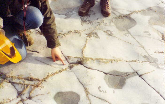
There are repeating sequences of calcareous mudstones, bituminous shales and argillaceous limestone in the Blue Lias cliff sections. A truely cyclical interpretation of these requires that the carbonate bands be at least partly primary in origin. There is, indeed, trace-fossil evidence for this. A problem, though, is how much is the present form of the carbonate of concretionary (diagenetic) origin. Both primary sedimentary differences and secondary diagenesis are, in fact, involved here (see papers of Hallam and of Sellwood and other authors).
Here is some obvious evidence for diagenetic processes involved in the formation of stone bands. The student is looking at an early concretionary carbonate nodule (is it the result of input of carbonate from the sea floor or of unmixing?) in cyclical calcareous shale/ bituminous shale sequences. The carbonate-shale sequences at the top of this image involve both primary differences and secondary concretionary carbonate. Sequences like this elsewhere may not always be correctly interpreted. Here, however, as previously mentioned, there is good evidence for a primary difference from trace-fossils (burrows have carried down carbonate), and good evidence for diagenesis from the lack of lateral continuity seen in the case here.
As shown in this photograph there is, the additional evidence for early lithification shown by the absence of compaction in fossils in Blue Lias limestones. Within the stone bands the ammonites are generally very well-preserved and uncrushed, although there are exceptions as shown below. In the shales they are very compacted and almost flattened. For more examples of uncompacted ammonites from stone bands, go to the ammonite section of the
Lias Fossils Webpage.)

In this unusual specimen there has been failure of the septa, but not the outer ventral wall. The septa have fractured in a brittle manner, with geniculate folds and fractures and some layer-duplication on a small-scale. The details of the processes involved here are not understood. It is not easy because this is probably an oblique section. It is probably from the top of the Top Tape Bed, but this is not proven.
.
BLUE LIAS
Cyclostratigraphy - Cyclicity in the Blue Lias

Close to medium-spaced, apparent cycles are conspicuous in the Blue Lias, as can be seen in various photographs of this webpage. At first sight it might be thought that these are obvious primary cycles rather like those that are familiar in the Cenomanian of southern England. Actually, they are not simple; they show diagenetic features, and they may not correlate well over a significant distance. It is not denied that they may represent some primary difference in carbonate content, but the diagenetic effects are more visible to the eye. Thus at certain horizons where diagenetic cementation has not occurred or not been complete some original cycles may be missed. A further complication is that in places there are bituminous shale - marl cycles without carbonate cemention. Thus the topic is an interesting one for discussion. However, it is only dealt in an incomplete manner here, and the full technical literature should be studied. This website introduces you to the cycles but does not necessarily give the latest and most up-to-date conclusions.

The main features of the Blue Lias cycles are shown schematically. Note particularly the various details of the limestone lithologies, including the bivalves, the burrow etc.; such features are shown in various photographs in this web page and the Lyme Regis to Charmouth webpage.
The origin of this apparent cyclicity is still problematical (see for example - Hallam, 1986). Are these 38 thousand year Obliquity of the Ecliptic or 22 thousand year Precession of the Equinox cycles? See
House (1985; 1986; 1993) . There has been signicant recent new work and discussion by
Weedon et al. who support the 38 ka obliquity cycle as the main one for the Blue Lias etc. (Rhaetian - Sinemurian). They have tried improved methods, with magnetic susceptibility measurements, and using time-series analysis. You will note from the paper that, although, obliquity cycles are favoured, there has been some argument, there are various uncertainties involved and that this seems to represent the best that can be done at present. The cycles may be better understood in the future with improved absolute dating of the Jurassic.
Notice that if the alternations between limestone and clay truely represent Milankovitch cycles, then the sedimentation rate for the lower part of the Blue Lias (the lower part of the cliff) was significantly less than for the upper part. The sequence represents a marine transgression following the deposition of the lagoonal limestones and shales of the Penarth Group ("Rhaetic" - uppermost Trias). Perhaps there was a lower sedimentation rate in the shallower water. Did the water deepen until the organic-rich Shales-with-Beef were deposited? Did the cycles expand, as a consequence of increased sedimentation rate, as deepening occurred? If this happened then why was so much organic matter accumulated at a time when sedimentation rate seemed to be higher?
CYCLOSTRATIGRAPHY
Blue Lias - Comparison with the Watchet Area, Somerset

A similar Blue Lias succession is seen at Watchet in Somerset and also on the South Wales coast.
BLUE LIAS DETAILS:
Bucklandi Sequence

Here is a small extensional fault (with rotation) in the top Hettangian and basal Sinemurian Blue Lias argillaceous limestones and shales. This is an easily found location and so some details of this are provided. The named beds of the Arietites bucklandi are quite easy to recognise just here, both in the cliffs and in the shore ledges. Specketty is almost at the top of the Hettangian (the base of Second Mongrel is a more precse boundary). The Mongrel is easily seen as a ledge nearby and the position can be checked against this very obvious bed. A double check is to find Top Tape (not far above), which has large Coroniceras ammonites. Note that all the "Quicks" are fairly thick, approaching 0.3 m. Notice that the Gumption Shales are very thick 1.27 m and they aid the recognition of a position in the sequence.
BLUE LIAS - DETAILS OF SPECIFIC BEDS
BLUE LIAS BED DETAILS:
31, The Third Quick (31) and Adjacent Strata

To consider cyclicity or rhythmicity in the Blue Lias it is interesting to discuss the sequence just above the Top Tape. Here some stone bands, such as the Third Quick, the Gumption and the Second Quick are very easy to recognise. At a distance these give an initial impression of some simple cylcity between carbonate stone bands and shales. However, closer examination will show that there thin bituminous shales alternating with marl in the major argillaceous units (such as the Third Quick Shales and the Gumption Shales) between the stone bands. In the photograph above members of Reading Geological Society examine the sequence. It is clear that if stone band to marl cyclicity is used it will give a different number of cycles than if bituminous shale to non-bituminous marl cyclicity is used. In the Kimmeridge Clay the cyclicity that is best developed is bituminous shale to non-bituminous marl. Stone bands (which are limited-burial dolomite unlike the Lias non-burial calcite) are not used in search for harmonics. In any case, there are not enough of them.
Incidently, early-cementation by calcite, as in the Blue Lias stone bands is known in the Kimmeridge Clay, but is mostly confined in Dorset to the rotunda Nodules, where the deeper bituminous sequence is phasing out into shallower water. The Lias only just reaches Kimmeridge Clay type conditions in proximity to the birchi Nodules, which originated in similar conditions to the rotunda nodules (however, note that there are differences in detail because the birchi nodules also contain burial dolomite on the outside - i.e. approaching the deeper Kimmeridge source rock facies).
(The Lower Lias does not seem to possess such a good oil source rock potential on the Dorset mainland as does the Kimmeridge Clay, with its Blackstone. However, it might pass offshore, southeast of the Isle of Purbeck into deeper, Kimmeridge Clay type facies. This would explain its apparent value as a source rock for the Wytch Farm Oilfield.)
BLUE LIAS - DETAILS:
The Top Tape (29) (ammonite bed)
[NB: The giant ammonites of the Blue Lias have been referred to in the past as species of "Coroniceras" or as species of "Arietites". This website does not make any claim to be a taxonomic study and it has been written at various dates and modified at various times and labelled photographs have been added at various dates. It should not be relied on with regard to which is the currently correct generic name; this is not really likely to cause any confusion.]
.


.

The Top Tape, bed no.29 is the easiest ammonite bed to find. The ammonites here almost form a pavement. They are dominantly Coroniceras (Metaphioceras) spp., including Coroniceras aff. conybeari Sowerby. The ledge is almost impossible to miss. It crops out on the shore in about the middle of Chippel Bay.
BLUE LIAS BED DETAILS:
25 - The Top Copper

The Top Copper is one of easiest beds to find in the Blue Lias of Lyme Regis. It is very pyritic and has small pyrite nodules and veins aligned along joints. There is, of course, no significant copper present. The name has come from the coppery appearance of the pyrite (iron pyrites, FeS
2
).
The relatively late date of the pyrite is shown by the relationship to the joints. The rock was already lithified (although this was a relatively early and pre-compaction process) and jointed, at least incipiently, before the pyrite was emplaced. This would seem to suggest that hydrogen sulphide was retained at this level to a greater extent than in other beds, although, of course, residual Fe might have been a controlling factor. The details are not known.
The Top Copper is in the basal Sinemurian. There is a Under Copper Bed lower down in the Hettangian.
BLUE LIAS DETAILS:
23 - The Mongrel (and 22 - The Mongrel Shales)

The Mongrel (limestone) is interesting in that it seems to show that the early nucleating centres for carbonate cementation were more closely spaced than was usually the case. Another curious aspect is that this is really a rhychonellid bed, although not generally known as such. The well-known rhynchonellid beds of the Jurassic of the Dorset Coast are the boueti Bed near the top of the Frome Clay and inconstans Bed near the base of the Kimmeridge Clay. These are generally regarded as of relatively shallow water origin, with sufficient oxygen for a good benthic fauna. They do not occur near oil shales in the succession (the Kimmeridge oil shales are much higher). Here we have a rhynchonellid bed just a very short distance above a bituminous shale that probably originated in hypoxic sea water (near the sea floor). This apparent rapidly of change of conditions is suprising. Compare and contrast with the environments of deposition the boueti Bed and the inconstans Bed and search for an explanation for the rapidity of change in the Blue Lias. Local tectonism, epeirogenesis, and eustasy can be discussed, as can major but rapid changes in palaeoclimate.
This is a difficult matter and various people may have different views. It is obvious that the Blue Lias originated in a very sensitive situation. It is a sensitive unit because it was transgressive but with an unusually low clastic input. The Kimmeridge Clay is quite different and does not start or end with closely spaced carbonate-clay cycles. It is Fe-rich at the base and sand-rich at the top. I suspect that the high clastic (and Fe from the rainforests) input later in the Jurassic had a buffering effect that destroyed sensitive cyclicity. The Blue Lias palaeoenvironment was unique because it was flooding a fine-grained argillaceous (Mercia Mudstone) and carbonate (Penarth Group) surface, with little sand. This situation did not last. Higher in the Lias the sand from the Sherwood Sandstone etc was reworked into the basin (Bridport Sands etc).
BLUE LIAS - BED DETAILS:
1. Brick Ledge and Vicinity
(Lang's Bed 1 above the shale H91 and the other H beds)
(Schlotheimia angulata Zone - Hettangian)

.

.

.

Brick Ledge is the lowest bed visible to the east of Lyme Regis, in the Chippel Bay Anticline (and the lowest in the Church Cliff Anticline). The bed is very well exposed to the west of Lyme Regis, as shown above. This and the underlying lower sequence (part of the Hettangian), the H beds, can be seen from the area near Seven Rock Point into Pinhay Bay. Brick Ledge, shown in the photograph here, is at the base of the beds worked for cement at Lyme Regis and thus it is the lowest named bed of the Blue Lias. It consists of several thin, and closely-spaced, beds of argillaceous limestone that are jointed in a brick-like manner (numerous close-spaced joints). Thus it is quite conspicuous and easily found.

.
BLUE LIAS FOSSILS
(See also Lyme Regis Fossils webpage)
BLUE LIAS FOSSILS:
Pentacrinites (Pentacrinus, Isocrinus)
(See also Lyme Regis Fossils webpage).

In certain beds of the Blue Lias succession, Lang (1924) has recorded ossicles of the crinoid - Pentacrinites (Isocrinus or Pentacrinus in the old literature). Beds mentioned as containing the remains of this benthic organism include: 22d (Mongrel Shales), 30a (Third Quick Shales), 32g (middle of the Gumption Shales, with Isocrinus (Pentacrinus) tuberculatus Miller, 41 (B92) Second Bed (a limestone). Of this listed occurrences only one, that in the Second Bed, refers to a limestone, although one without ammonites listed. The photograph above shows abundant coarse-ribbed ammonites (i.e. like Coroniceras). Note that of the above occurrences, Bed 30a (basal Third Quick Shales) is immediately above the Top Tape (29 or B80). Therefore it is quite likely that the photograph shows the top surface of the Top Tape, although this is not proven.
It is interesting to note that Pentacrinites often occurs with Gryphaea arcuata, although the oyster is more widespread than the crinoid. The co-occurrence is presumably the result of sea-floor conditions favourable for benthic faunas.
BLUE LIAS FOSSILS:
Gryphaea arcuata


Gryphaea arcuata Lamarck, a Jurassic oyster which is colloquially known as the "Devil's Toe-nail"
(and once named "Gryphaea incurva"). This asymmetrical oyster-like bivalve lived in the mud on the early Jurassic sea-floor. A set of Gryphaea shells worn through can be seen in some of the ledges, as shown above. Many that are visible in section, but good complete specimens are difficult to find here. For more information on Gryphaea arcuata see the book: Gould, S.J. 1980. The Evolution of Gryphaea (available online).
When considering Blue Lias cycles, a relevant point regarding the Gryphaea shells is that they demonstrate that the basal seawater was not anoxic at the times when these lived. The thin beds of bituminous shale in the Blue Lias need faunal examination to determine to what extent the oxygen-supply conditions were different.
Lang (1924) reported Gryphae arcuata (as Liogryphaea arcuata and Liogryphaea sp.) and related species in the following beds:
49 Grey Ledge
34 Second Quick Shales
31 Third Quick ("full of Gryphaea")
30 Third Quick Shales
27 Second Tape (with a var. striata)
26 Second Tape Shales (several!)
24 Top Copper Shales (under the Top Copper)
21 Second Mongrel
20 Second Mongrel Shales
19 Specketty
18 Specketty Shales
17 Upper White (very bioturbated bed)
16 Upper White Shales
14 Upper Skull Shales
7 Lower Skulls
(It is obviously quite widespread through the upper Hettangian and much of the Sinemurian. This is, of course, not necessarily a complete list of possible occurrences of Gryphaea arcuata etc; generally other oysters, such as Ostrea irregularis appear lower in the Blue Lias sequence)
BLUE LIAS FOSSILS
Ammonite, probably from Grey Ledge

A fine ammonite specimen has been carefully prepared, and the finished ammonite is shown in this photographs. This been identified by Murray Edmunds as Paracoroniceras lyra Hyatt. It is from the lyra Subzone at the base of the Semicostatum Biozone, high in the Blue Lias of Chippel Bay. The specimen was found and excavated by Martin Foster, Mark Hawkes and Ian Troth in the summer of 2001. Dr. Ian Troth, shown with the specimen, is a petroleum and gas exploration geologist, a former student of Southampton University, and is a keen fossil collector.
The original specimen was a grey block of limestone on the shore with just part of an ammonite showing. Preparation by Mark Hawkes from Stone Treasures, has revealed not only the excellent shell of the ammonite but also a nautiloid that was in the same block. Ian Troth considers that the nautiloid was originally beneath and that the ammonite shell fell onto it. Early cementation of the argillaceous limestone bed in the Blue Lias prevented major compaction from taking place. Only some minor breakage of the nautiloid body chamber has taken place from the ammonite pressing down on it. Arnioceras shells are present on the other side of the block and it has almost certainly come from the semicostatum zone, perhaps from Grey Ledge.
It should be stressed that this is a rare specimen. Ammonites of this species are not as well preserved as the above specimen from this locality in general. This is because the umbilicus, the first few whorls, is often missing. Collection is difficult because of the weight Although there are specimens loose on the beach, the majority are waterworn and incomplete. They are perhaps best left for others to see.
Notice the strong, well-spaced ribs which are near rectiradiate (i.e. radial) except for the forward deflection at the venter (the outside). A tricarinate keel (three ridges on the venter) is present.
(Compare to poorly preserved specimens of Coroniceras or Arietites shown elsewhere on this webpage.)
BLUE LIAS FOSSILS:
Ammonites with Impact Damage (Top Tape)


Ammonites of Coroniceras type in the Top Tape are of special interest in sometimes showing post-mortem, penecontemporaneous damage. One example above is unusual in that the dead shell on the sea-floor was hit hard by an impacting narrow object. It was in sense, bayoneted. The force broke and displaced the shell. The nature of the impactor is not known. It might have been the jaw of an ichthyosaur. The force of the impact was quite substantial. These ammonite shells are corrugated with ribs and were probably quite strong. One whorl was torn away to some extent from another by the blow. This could only have happened easily if the body chamber in the outer whorl was already mud-filled. Some attached ?)small oysters suggest that this ammonite, like others in the same bed, was exposed on the sea-floor as part of an ammonite pavement. It has been mentioned to me, by a passing student from Portsmouth University, that squids may have attacked recently fallen ammonites on sea floor.
Another ammonite with a penecontemporanously displaced outer whorl is also shown above. The ammonite pavement seems to be attacked or disturbed in places by some marine creatures.
BLUE LIAS FOSSILS
Nautiloids (Top Tape and Vicinity):
Fill and Cementation
(For more information on fossil remains from the Lias locality see:
Go to - Fossils of the Lias )


Nautiloid specimens in the stone bands are of potential interest regarding the history of the seawater and subsequent interstitial brine. The shell descended to the sea floor in vertical orientation, perhaps because of gas in the chambers. When it settled edge-on into the calcareous mud, some of the mud entered the chambers shown. These were only partial infills and thus geopetal structures are observed, with empty cavities above the carbonate mud.
Subsequently, the aragonite shell of the nautiloid seems to be been largely replaced by neomorphic calcite. However, this has not been complete and there is a cavity (top of photo) where residual aragonite has been dissolved. Some some small bivalves were washed into the chambers with the mud (they also show that the sea floor was not anoxic). The aragonite shells of these have been dissolved away after burial and narrow cavities are now present (i.e. the shells are internal moulds).
There does not seem to be any significant external growth of non-replacive calcite spar on the shell. However, in the unfilled parts of the chambers there
is well-developed scalenohedral calcite spar that grown into cavities. This non-replacive spar might contain a good isotopic record of subsequent interstitial brine chemistry. The specimen has not been collected or studied but this or similar material could probably be found if needed for research purposes.

This particular specimen of a nautiloid in the Top Tape Stone Band reveals information on the early cementation. The main cementation obviously occurred before any significant burial and was within a few metres at most of the sea floor. However limited cementation continued as burial reached about 10 or 20 metres and then stopped. After that there was major compaction and cephalopod shells were crushed to less than about 5% of their original thickness. It is no surprise, of course, that the cementation was very early but it is interesting to observe that the cementation declined so rapidly with only limited burial! (This is different from Kimmeridge Clay dolomite cementation - down to 1 km.).
BLUE LIAS SEDIMENTOLOGY AND SHALE GAS (FRACKING)
BLUE LIAS - SEDIMENTOLOGY:
Expansion Diagenesis


Until about the 1930s it used to be thought that septarian nodules have internal cracks as a result of contraction. It is now well-known now, of course, that such nodules show expansion features on their exteriors, often with burst fossil shells. A rarer process is whole-bed expansion as is well-demonstrated by the diagenetic dolomites of the Kimmeridge Clay. The details of these processes need not be discussed here (see Kimmeridge Bay webpage for more on this). An interesting aspect of the Blue Lias is that expansion evidence is very limited. Of course vertical expansion might not be conspicuous. Lateral expansion may not have been confined, as in the case of the Kimmeridge dolomites. The Blue Lias has not undergone significant burial diagenesis and the carbonate bands are very early. In spite of this an occasional case of expansion diagenesis can be seen, as in the case of the shell of the Plagiostoma giganteum above. It is quite probable that this feature is one of an initial small septarian nodule, containing a Plagiostoma, acting as a nucleus for a Blue Lias carbonate band of normal type. Notice that this not a case of compressional shell collapse because the broken shell has not been pushed out towards the periphery, and the gaps are relatively uniform.
BLUE LIAS SEDIMENTOLOGY:
Pyrite amd Pyritisation - Introduction


Pyrite (ferrous sulphide - FeS2 ) is common in the Lower Lias. In an image above is a fallen blocks containing the uncompacted shell of an arietitid (i.e. large and strongly ribbed) ammonite which has been replaced by pyrite. The shell would have originally been of aragonite, the orthorhombic form of calcium carbonate, and the pyritisation has most likely occurred after burial. The pyrite has not replaced the shell in a neat pseudomorphic manner but is rather irregular and nodular.
In another photograph pyrite is seen as as veins in the Top Copper Bed, just above the Mongrel. Presumably the bed received its name from the abundance of pyrite (but note that this is iron pyrites not copper pyrites or chalcopyrite). The reducing (anoxic) conditions in the sea-floor sediments, and sometimes in the lower water column, were produced by the large supply of organic matter. Sulphate-reducing bacteria reduced the sulphate ions of seawater to sulphide, producing the unpleasant gas - hydrogen sulphide in solution. This would have reacted with any iron available to produce the brassy-looking ferrous sulphide - pyrite (not necessarily directly but, perhaps, via hydrotroilite). Pyrite is easily formed by decomposing organic matter in the presence of iron.
Pyrite is normally abundant in black shales with high organic content. It is frequently present in oil source rocks. An unusual feature is that the pyrite is aligned along some pattern of joints (cracks) but not all the present, open ones. Pyrite is normally produced by hydrogen sulphide gas early after sedimentation. Later when the sediment entered the methane fermentation zone, this precipitation should cease. Note that because of early lithification, the cementstone was already brittle and subject to some fracture at a time when hydrogen sulphide was still present and locally migrating. See more on this subject below.
.
LIAS SHALE GAS PRODUCTION (re: Lias Fracking)
Natural Processes:
(Bacterial Sulphate Reduction and Bacterial Fermentation)

There is obvious field evidence in the "Copper" beds of the Blue Lias that hydrogen sulphide was generated and migrated locally shortly after the initial cementation of the stone bands. There can be little doubt that this was a feature of Diagenetic Zone 2 (Irwin et al. 1977). The obvious question that arises with regard to possibilities of shale gas hydraulic fracturing (fracking),is whether the next stage, Diagenetic Zone 3 (Bacterial Fermentation) produced methane. There is no doubt from diagenetic studies (Bellamy, 1980) that the Lower Lias sequence has been through the Fermentation Zone 3. What is not know is how much, if any gas, has been retained. The matter is of interest because a possible French programme to
obtain gas by "fracking" from Liassic shales.
(to be continued)
.
BLUE LIAS QUARRYING
BLUE LIAS QUARRYING:
Quarrying the Blue Lias Cliffs for Cement
Lyme Regis was once celebrated for its hydraulic lime and cement. This was quick setting in marine conditions (Woodward and Ussher, 1911) and was particularly useful for harbour works. The Lyme Cement Works operated in the Ware Cliffs as shown above, between Devonshire Head and Monmouth Beach, and was established by Mrs Eleanor Coade of Belmont House, Lyme Regis (Legg, 1999). She died about 1820. De la Beche remarked that when Smeaton built the Eddystone Lighthouse he obtained Lias lime from Aberthaw in Glamorgan, but if the geological knowledge had been available at that time he could have got it from Dorset. Relics of a 19th Century cement industry at Lyme Regis are old railway lines on the shore in Chippel Bay, and which are still visible at low tide. The argillaceous limestones of the Blue Lias were used and so also were cementstones in the clays and shales above. The stone was originally collected from the fallen blocks on the beach in the bay, and when this had been used up, the cliffs were blasted to bring down more material. This industry resulted in the naming of individual stone beds, to the benefit of geologists. The quarrying seems to have been done regardless of some concern in the area about this type of human coast erosion (particularly complaints about destruction of ledges near the central part of Lyme Regis). There was a cement factory at Monmouth Beach, west of Lyme Regis from 1850 to 1914 (Thomas, 1993). the kilns here probably gave off the polluting, sulphurous fumes that are associated elsewhere with limekilns burning pyritous limestone! Much material has also been shipped from the Lyme Regis coast in the raw state, at one time about 120 tons a week (Woodward and Ussher, 1911). These authors mentioned that the cementstones, with a higher clay content and more aluminium and soluble silica, made better cement that set somewhat harder and had a higher density.
See also the Charmouth Field Guide, regarding the cement factory at Charmouth.
.
PINHAY BAY AND THE PENARTH GROUP ("RHAETIC")
INTRODUCTION: PINHAY BAY (PINNEY BAY):
Pinhay Bay, west of Lyme Regis.


Langport Member of the Penarth Group (Rhaetic)
Slumping


.
Pinhay Bed is important for the Triassic - Jurassic boundary. It shows an interesting and unusual Penarth Group ("Rhaetic") succession. This has been much studied by Hallam. It is also notable, not only for faunal peculiarities but because of unusual slump features.


A recent paper is that of Wignall (2001) , which provides new sedimentological data and interpretation. The title and abstract of Wignall's paper is given below:
Wignall, P.B. 2001. Sedimentology of the Triassic - Jurassic boundary beds in Pinhay Bay (Devon, SW England). Proceedings of the Geologists' Association, London, 112, 349-360. Abstract: New exposures in Pinhay Bay (SE Devon) of the White Lias (Langport Member of the Lilstock Formation) and basal Blue Lias reveal rapidly changing palaeoenvironments during the Triassic-Jurassic (T-J) boundary interval. During deposition of the topmost White Lias a soft seafloor of micritic mudstone was lithified and bored. The resultant hardground was locally eroded, probably in a shallow marine setting, to form a spectacular intraformational conglomerate that was itself lithified. Brief subaerial emergence then followed and produced a fissured and pitted top surface to the White Lias. The regression was short lived and rapid transgression at the base of the Blue Lias established organic-rich shale deposition with a small framboidal pyrite population and low Th/U ratios indicative of a stable, sulphidic lower water column (euxinic conditions). The White Lias/Blue Lias contact thus records a short duration, high amplitude relative sea-level change. This sea-level oscillation has also been postulated for other J-T boundary sections in Europe, although failure to identify it in regional-scale sequence stratigraphic studies is probably due to its brief duration. Deposition of the basal beds of the Blue Lias was marked by a discrete phase of syn-sedimentary folding and small growth fault activity that may record a regional pulse of extensional tectonic activity.
Langport Member - Mollusc Moulds

PINHAY BAY:
The Triassic-Jurassic Boundary


(preliminary note: Earthquake slumping is obvious in the White Lias. Events here were quite major. Such features are not common in the overlying Jurassic and Cretaceous sequence until the Unio Bed of the Upper Purbeck Formation of Stair Hole is reached. That case of small-scale liquefaction coincides with a phase of the Late Cimmerian Tectonics and is associated with local faulting and erosion.)

(preliminary note: The Sun Bed at the top of the White Lias has desiccation cracks. It would not, therefore be surprising to find moulds of halite crystals in this vicinity. The presence of former evaporites, perhaps dispersed gypsum and halite, in the White Lias might, perhaps, have facilitated tectonically-produced slumping.)


PINHAY BAY:
Upper Greensand - Fossil Wood


Carbonised tree remains were found in fallen blocks of hard, bioturbated, calcite-cemented sandstone in Pinhay Bay. These blocks are predominantly grey rather than green, although probably containing glauconite. Part of the tree remains consist of the root. This is characterised by numerous branching tubules, and has, therefore, some similarity in appearance to the roots of tree ferns (Tempskya). However, the tubules might not be structural features of the wood and might instead by borings of a Teredina-like bivalve (I thank Richard Edmonds and Ramues Gallois for comments on this).
However no detailed study of the fossil wood has yet been made and it is not yet know whether this is a bored tree is of this origin, or whether there really are adventitious roots (as occur in Tempskya, the fossil tree fern).
THE AXMOUTH - LYME REGIS UNDERCLIFFS
LOCALITY:
Axmouth-Lyme Regis Undercliffs - Introduction
(including the Dowlands-Bindon Landslip etc., and
all the collapsed and slipped cliffs between Pinhay Bay and Haven Cliff, Axmouth)

.
[ ]
]


There is a long coastal footpath through the Axmouth-Lyme Regis Undercliffs (or Bindon-Dowlands Landslip). There is not much access to geological exposures from this and it is mainly just a walk through dense forest. The path is easy but with steps up and down at intervals and quite long in total. There is no access to the beach, except private access. In summer the vegetation prevents much view of the beach or cliffs. This is one of the most inaccessible parts of Jurassic Coast, UNESCO World Heritage Coast, and it is a nature reserve. Although to the geologist it may at first seem to be a slightly difficult place, not of easy access. However, it is actually very good and has a very interesting geological and geomorphological history. The landslide history is notable and famous, and it also contains important geological sections relating to the Triassic-Jurassic boundary.

UNDERCLIFF-LOCALITY:
Blue Lias Cliffs Directly West of Pinhay Bay


A major fault runs NNE-SSW through Pinhay Bay, a little to the west of centre (See BGS 1:50,000 Solid and Drift Geological Map - Sidmouth). To the west of this fault there is another cliff section, albeit less impresive, of Blue Lias. This extends for about half a kilometre. In the photograph above students are seen at this section, on the beach between Whitlands and Pinhay Bay, in 1993. They are heading eastward towards Lyme Regis in wintry weather (actually in Spring). The party has descended from the main footpath in the area of the Pumping Station in the Lyme Regis - Axmouth Undercliff.
UNDERCLIFF-LOCALITY:
Humble Point and Humble Rocks (Whitlands)
(headland, beneath the Undercliff, and west of Pinhay Bay)


Humble Rocks, west of Pinhay Bay form a rough headland, Humble Point. This is within the eastern part of the Axmouth - Lyme Regis Undercliff. This is a notable landslide locality, with the landslipped Whitlands above. Here, on the shore, many large, rectangular blocks have fallen from the upper part of the Upper Greensand, including the Chert Beds. On the beach here and elsewhere in the area there are many Cowstones from the lower part of the Upper Greensand. These are ovoid or rounded, grey when unweathered but becoming yellowish-brown on weathering. They consist of very bioturbated, carbonate-cemented sandstone.
LOCALITY:
Charton Bay - General
(South of the Axmouth-Lyme Regis Undercliff)
.

Charton Bay has a private beach, relating to properties at the cliff top. Until 1969 there was a cart road down to the shore (Arber, 1973, p. 129). On the 22nd June 1969 a landslide occurred here, so that the cart road was broken by a sheer drop of about 14 metres, and at that time the only way to the beach was by use of ropes. On the seaward side of this new scarp there were two great ridges of rock resembling masonry. This area is now heavily overgrown with vegetation. Arber noted that there was no complimentary rise of the beach or sea floor, as had happened at Humble Point.
At the present time (2011) there is a narrow private footpath largely composed of railway sleepers and a ladder to the beach. Ladders do not always survive for long on the erodable Jurassic strata of the south coast of England (e.g. the ladder at Freshwater Steps has gone, and a ladder is replaced every two years at St. Gabriel's mouth). The combination of coast erosion steepening the foot of the cliffs and of increase in cliff vegetation in recent years seems to making access to the bases of cliffs more difficult in various places. In the notorious landslip area of the Axmouth - Lyme Regis Undercliffs the future is obviously unpredicable, but the coast is unlikely to remain the same for a long period.
.

.

.
Flint shingle is at present accumulating at the eastern end of Charton Bay. This is shown by a high shingle beach, no cliff erosion behind it, and the growth of sea plants on the top of the shingle. This is a common phenonemon in the down direction of longshore drift, here west to east. It should correspond to erosion in the western part of the bay.
.

.


.
LOCALITY:
Charton Bay - Penarth Group
(Trias - formerly Rhaetic White Lias etc.)


The best section of Penarth Group, or at least the upper part of it, is in Pinhay Bay, described elsewhere in this webpage. The Charton Bay section is not recommended for the general geological visitor except for comparison with the Pinhay section.
It could be useful to specialists. At present, the Charton Bay exposure is in rather degraded condition because of landsliding and growth of vegetation. It can be reached at round about 40 metres above the beach, and about 20 metres east of the Charton Bay side path (from the main route through the Undercliff; use of this is discouraged as shown by the danger and private property sign at the entrance to it. This may not be the only exposure but it can be reached if necessary. It requires scrambling through brambles over fissures and up rock faces and is unsuitable for a party (for which it is best to go to Pinhay Bay). Most of the strata exposed belong to the White Lias or Langport Member of the Penarth Group. There are some small and unsatisfactory exposures of the Westbury Member and Cotham Member.
Penarth Group Sccession - General
The general succession of the Penarth Group is given here for reference purposes. This is the summary succession is partly based on that by Arkell (1933) and partly on Woodward and Ussher (1900), with some updating.
Langport Member (White Lias),
7.6m. generally (Arkell, 1933); 4.57m. at Culverhole Point (Woodward and Ussher, 1900)
Thin beds of white limestone, here and there wedge-beded, with slumped beds, slump balls, convolutions, and "pebble beds" which are slumped micrites containing small subrounded clasts of hard porcellanous limestone. Some thin horizonal layers of porcellanous limestone also occur. The sequence is not highly fossiliferous but the middle and upper portions contain Ostrea liassica, Protocardia, Dimyodon intusstriatus, and a few ill-preserved fragments of other fossils. The fauna is limited and somewhat reminiscent of the lagoonal to near-marine fauna of the Purbeck Formation at the Jurassic-Cretaceous boundary.
Cotham Member
(1.5m generally - Arkell, 1933; 20cm of Cotham Stone at Culverhole Point - Woodward and Ussher, 1900)
The Cotham Marble is an impersistent, pale greenish grey limestone, only 3.8cm. to 20cm thick, and at the top of the Member. It is slightly pyritic and "arborescent". It is recorded as stromatolitic elsewhere. The remainder of the unit, beneath, consists of dark shales with two thin limestone seams. The shales yield ostracods (Darwinula), fish scales, saurian coprolites and Cardium cloacinum.
Westbury Member (Contorta Shales)
(5.2 metres - Arkell (1933); 5.4 metres at Culverhole - Woodward and Ussher (1900).
Black and brown fossiliferous shales with three thin limestone seams. The shales are laminated and contain much selenite (resulting from oxidation of pyrite). They yield the following fossils: Pteria contorta (very abundant), Chlamys valoniensis, Myophoria emmrichi, 'Schizodus' ewaldi, Placunopsis alpina, Protocardia rhaetica, Pleurophorus elongatus; also the fish Acrodus minimus and Gyrolepis alberti. At the base is the Bone Bed, 5 cm. thick, conisting of indurated gritty black shale, full of small bones, scales and teeth of Gyrolepis alberti, Acrodus minimus, Saurichths acuminatus, ?Sargodon, Lepidotus and Hybodus with coprolites.
On eroded surface of the Blue Anchor Formation (Tea Green Marls). The Sully Beds and certain of the lowest beds of the Contorta shales are missing.
At the present little of the lower part of the Penarth Group is clearly seen in Charton Bay. The main exposure is of the Langport Member (White Lias). The base of the Blue Lias, and much fallen debris of Blue Lias cementstone is seen nearby.


The Langport Member of the Penarth Group (the White Lias) is exposed in the collapsing cliffs of Charton Bay. It is not necessarily easily found or of easy access but I was shown it by the kindness of Dr. Ramues Gallois, the expert on this area. An interesting feature is the occurrence of U-shaped burrows in the top bed, the Sun Bed.
Professor Tony Hallam (1960) has described these U-shaped burrows:
"The Sun Bed is riddled with the U-shaped burrows of the trace fossil Rhizocorallium ... which have the characteristic median septum or 'Spreite' [they do not actually seem to resemble the sub-horizontal burrows of Rhizocorallium when seen in the field and, at a glance, more resemble Arenicolites the intertidal worm, but I have not made any detailed study and may be wrong]. They were produced by sediment-feeding organisms, probably some form of worm or crustacean. They are best seen in the Charton Bay section; on the Pinhay Bay foreshore truncation of the tops of the burrows indicates that two inches [5 cm.] of the Sun Bed have been removed by erosion. A striking feature of these structures is they are surrounded by a zone of bleached rock some quarter of an inch [6 mm.] thick which is itself surrounded by a band of dark band up to one twelfth of an inch [2 mm.]. Microscopic examination reveals that these differences are due to the uneven distribution of pyrite granules [framboids?]; they are absent from the bleached zone and concentrated in the dark zone. The suggested explanation is as follows. Perhaps but not necessarily during the decay of the organism sulphurous fluids migrated into the rock. Pyrite granules were dissolved and the solution progressively concentrated until at a certain distance from the burrow the solubility product of FeS2 was exceeded and the mineral rapidly precipitated, giving a dark band. This process is essentially similar to the process of gleying in soils." [Hallam (1960) subsequently commented that the burrows must have been excavated in soft sediment. This does indeed seem very likely; the surface is a burrowed one, not a bored one.]
It may be concluded that the Langport Member largely consisted of sediments which had just slumped and then were exposed at or near to the surface so that conditions were oxidising. This would seem to explain the ferric iron, its increase upward and the local reduction in the burrows.


The Cotham Member of the Penarth Group in Charton Bay contains some interesting ripple marks seen in small loose blocks on the shore. They are probably interference ripples which show upbuilding in cross-section. They seem to be wave ripples from a shallow, shore environment. The cross-sections of the ripples shows other unusual structures in addition to the rapid upbuilding; These include some superficial resemblance to hummocky cross-stratification on a small scale. No serious study has been made, though. The ripple index (L/H) is very low. Like wave ripples on modern intertidal beaches, these ripples contain fine plant debris. This material might be worth checking by a specialist for fossil insects, since it resembles the fine plant debris common in the insect beds of the Purbeck Formation of Dorset.
LOCALITY:
Charton Bay:
Blue Lias

The Blue Lias is not easily accessible in a clean section in Charton Bay but there is some exposure. It is present in the mid-cliffs, above the White Lias. However, these cliffs are very landslipped and much vegetated with brambles etc, so they are not places of easy access. Bed H1 and H2 are seen just above the top of the White Lias or Langport Member. Fallen Blue Lias material is present on the beach.
LOCALITY:
Charton Bay:
Shingle Beach


The beach of Charton Bay is somewhat surprising when encountered after walking from Lyme Regis. It seems to be a mature beach of largely flint pebbles with some chert. These pebbles are mostly subrounded, and give the impression that beach is quite old. They are not as worn, though, as on the Chesil Beach. It is interesting to note the common occurrence of Budleigh Salterton quartzites. It used to be thought that it was difficult for such pebbles to pass eastward of Beer Head. However, they may have been transported in the past when there was a more continuous west to east beach at a time of lower sea level. Beer Head may be a fairly recent feature, in Quaternary terms.
LOCATION:
Dowlands Landslip, Goat Island and Culverhole Point


.
Immediately north of Culverhole Point, a conspicuous headland of landslid Chalk, is the famous Dowlands landslide area. Here the upper part of the cliff collapsed on a large scale at Christmas 1839. A separated block became known as Goat Island. It was a block of formerly cultivated farmland, and the corn was cropped the following year after the landslide. The surrounding area is now heavily forested by the upland of Goat Island still has less trees than the surrounding area. The Chasm at the back of it is now full of large trees.

The illustration above is modified after a drawing by Sir Archibald Geikie (possibly after a photograph), subsequently reproduced by various authors, including Woodward and Ussher (1906) and Arber. It shows Goat Island as an isolated block with fields and field boundaries.
A summary of the landslide activity at Dowlands and Bindon was given by Woodward and Ussher (1906). This is reproduced below:
"The most extensive landslip, however, that occurred in this country during the last century happened in December 1839, in the cliffs between Bindon and Dowlands. The summer and autumn months had been extremely wet and for more than a week before the founder great cracks or clefts had been observed along the brow of the cliffs. The slipping began early on Christmas morning, but the main mass subsided on the following day, when about 40 acres broke away from the cliff and foundered towards the sea. The result was a chasm from 200 to 400 feet broad, from 130 to 210 feet deep, and about half a mile long, and in the midst of a belt of broken ground subsided. It was estimated that about eight million tons of rock subsided. The pressure of the foundering strata upheaved the sea-bottom adjoining the coast producing a reef, nearly three quarters of a mile long and 40 feet high in places, and this was at the time covered with marine organisms.
The consternation in the neighbourhood was great, many persons attributing the occurrence to an earthquake; indeed, "A brief account of the Earthquake" was published in London. This inference is interesting, as there is a record of an earthquake having happened in Lyme Regis in 1869; and we are thus warned not to place implicit reliance on such records.
At the time Buckland was staying in Lyme Regis, and Conybeare was in his vicarage at Axminster. To them and to W. Dawson, Civil Engineer for Exeter, we are indepted for full particulars of this great landslip; while a more handy guide was published in 1840 by George Roberts (the historian of Lyme Regis) and this reached five editions during the year...
[Roberts, G. 1840. An Account of, and a Guide to the Mighty Land-slip of Dowlands and Bindon, in the Parish of Axmouth, near Lyme Regis, December 25th, 1839. (5 editions in 1840). 8vo. Lyme Regis. With the incidents of its progress, the locality, historical particulars, its causes popularly treated, and the claims of being the effect of an Earthquake considered, with mention of more recent movements at Whitlands, February 3, 1840.]
More detailed information has been provided by Arber (1940; 1973 and other papers). Later accounts and surveys with excellent old illustrations are given by
John Pitts (1974; 1982 etc) and this includes much details from old publications, such as that of Conybeare et al. (1840). The slip was observed by two coastguards who saw the land cracking and heard a sound like "the rending of cloth". There was also heaving and disturbance of the beach, the sea being violently agitated while a dark ridge rose in the water. This was accompanied by a "deafening crashing of falling rocks" and "flashes of fire and a strong smell of sulphur".
"One of the parties observed about midnight the very commencement of the fissures, which in their subsequent progress led to the formation of the great chasm more than 300 feet broad, and 150 feet deep and three quarters of a mile long, ranging as a chord across the curve of the upper headland."
"A little after midnight, three hours after the land began to subside to form the chasm, these men were alarmed by the upheaving of the submarine beach, and .. the alteration of the shore, protrusion of the cliff etc."
The remains of the uplifted reef can still be seen on aerial photographs of the Channel Coastal Observatory taken at low tide in 2006 - see image above.
LOCATION:
Culverhole Point - Cliffs
An old account of the cliffs at Culverhole Point has been given by Woodward and Ussher (1900). A field party of about 40 members of the Geologists' Association had been staying at the Royal Clarence Hotel, Seaton (it is still there). On Friday the 30th March 1899 they started at 9am to walk along the esplanade to Axmouth Bridge. They walked via Barn Close and Stony Close Lanes to the top of the Great Landslip of 1839 at Bindon Cliffs where they had a striking view eastward through the Chasm. Note that at this date there was probably still sheep-grazing taking place and there was not the dense vegetation of modern times; old routes are not always feasible now.
"Leaving the chasm, the members proceeded a short distance westward along the brow of the cliffs and descended by a foot-path to the shore a little west of Culverhole Point. Here in the low cliffs fringing the beach a fine section of Rhaetic Beds [Penarth Group] was exposed. On the west side, and indeed from the mouth of the Axe eastwards to near Culverhole, the high cliffs are formed of Chalk and Greensand [Upper Greensand], resting on a foundation of the red and variegated Keuper Marls [Mercia Mudstone and Blue Anchor Formations of the Trias]. These marls are bent into gentle undulations, and they are displaced by several faults which cut the cliffs obliquely and sometimes nearly parallel with the coast. Near Seaton and Branscombe they contain gypsum and pseudomorpous crystals of rock-salt [halite]. Towards the top of the red marls [Mercia Mudstone] there is a layer of hard pale-grey or buff banded marl with dark clayey streaks, which marks the commencement of the gradual change in conditions into the succeeding Rhaetic series [Penarth Group of the top Trias].
The strata dip eastward at an angle of about 5 degrees, and within a short distance the entire Rhaetic series [Westbury Member, Cotham Member and Langport Member of the Penarth Group] is exposed. These beds again are displaced by slight faults, some of which, however, appear to be due to landslipping. Resting on the White Lias [the Langport Member of the Penarth Group] there were some pale grey clays belonging to the base of the Gault, and it is interesting to note that Conybeare had in 1840 [Memoir on Landslips, p.2] referred to a possible trace of Gault near Culverhole.
The section seen at Culverhole was as follows [format modified and updated]:
PENARTH GROUP ["Rhaetic Beds"]
Lilstock Formation
Langport Member (Lilstock Fm.)
["White Lias"]
Thin-bedded white limestones, here and there wedge-bedded, and with concretions or pebbles of compact limestone [porcellanous limestone "pebbles" in a "pebble bed" chaotica debrite]in the lower part.
[i.e. this is a similar slumped sequence to that at Pinhay Bay, where it is 7.8m thick]. - 4.6m (15 feet).
Cotham Member (Lilstock Fm.)
Impersistent masses of rudely arborescent Cotham Stone [stromatolitic limestone], about 0.20 m (8 inches).
[This is given as a very thin unit; it is listed as 1.5 metres at Pinhay with a thin stromatolitic bed at the top (House, 1993). For correlation with Pinhay, some of the underlying shales may be included in the Cotham Member.]
The Westbury Formation
["Black Shales"]
Contorta Shales
Avicula contorta Shales with bone-bed at the base. About 5.5m (18 feet) [compare to 5m at Pinhay Bay].
Blue Anchor Formation
["Tea Green Marls" of the Trias]
[25 to 28 m according to the BGS Sidmouth Sheet, but given as only 9m here, the matter probably dependent on just what is considered the base]
Green Marl - 3m (10 feet)
Alternations of pale greenish and creamy marls with hard bands of marly limestone and dark grey and black clays - 6m (20 feet)
MERCIA MUDSTONE GROUP
Branscombe Mudstone Formation [of BGS, Sidmouth Sheet]
["Keuper" of the Trias]
Dark, light grey, green and red cuboidal marls [mudstones] - above -
Hard layer of pale-grey or buff banded marl with dark clayey streaks. Total thickness for these two Mercia Mudstone units - 4.6m (15 feet).
Green, grey and red marls. (no thickness given)
Red and variegated marls. (no thickness given)
[bottom of short log]
[continuing with the report of the 1899 field trip]
The Bone Bed and Contorta Shales
"The Axmouth Bone-bed lies at or near the base of the Black Shales. The rib of a Reptile was observed by Mr. E.T. Newton near the base of the Shales, while numerous Fish-remains, including Acrodus, Gyrolepis alberti, Agassiz, Hybodus, Lepidotus, and Sargodon? were identified by him from specimens obtained in crevices of the Green Marl [top of the Blue Anchor Formation] at the base of the Black Shales [Contorta Shales of the Westbury Formation].
Numerous fossils were found in the Black Shales, including the characteristic Avicula contorta, Portlock, also Anatina praecursor, Quenstedt, Cardium rhaeticum Mer [Protocardia rhaetica], Hinnites, Modiola, Pecten valoniensis, Defr. and Pleurophorus.
[Note: If there are crevices in the Blue Anchor Formation marls were these already relatively lithified prior to deposition of the Bone Bed?]
LOCATION:
Haven Cliff, near Axmouth (west of Culverhole Point)


From the mouth of River Axe at Axmouth Bridge it is easy to walk eastward on the beach pebbles beneath Haven Cliff in the direction of Culverhole Point. There are good exposures of the upper part of the Mercia Mudstone and of the Blue Anchor Formation.


Nearer to Culverhole Point there is a good section of land-slipped "White Lias" or Langport Member of the Penarth Group. It is very slumped as at Pinhay Bay.

Examine the photograph above of mouldic secondary porosity in the White Lias. You can immediately see something of the early brine history. Notice that the primary sediment was dominantly calcite and not aragonite. Observe that the interstitial brines at the time of slumping were saline, not meteoric. This, of course is what you would expect. Cementation was very early, post-slumping. The peculiar cementation in proximity to this bed is likely to be part of this story. The brines clearly became very carbonate saturated while still retaining a moderately high Na content (i.e non meteoric). These are the simple observations from field study; in reality the diagenesis was probably more complicated because of the possible former presence of other carbonate minerals such as high-Mg calcite, dolomite etc. Local celestite at Pinhay Bay shows that sulphates were also involved, and that some post-depositional interstitial brines were high in Sr. A question that is unresolved from field study is whether gypsum was surviving late in the interstices of the White Lias limestones.
The main point regarding the argument above is that it implies a meteoric water phase in the very late Trias. The main Blue Lias sequence shows no evidence of a meteoric phase (it is pyritic almost throughout). A brief uplift into the meteoric zone (i.e. above sea or lagoon level) presumably took place shortly after slumping (was this the result of local tectonics or Late Triassic eustasy?).
[Question for students: Compare and contrast with the early cementation of the Portland Roach, with its well-known mouldic secondary porosity. In that unit when did salinity-reduction of interstitial brines first take place?]
LOCATION:
Shapwick Grange Chalk Quarry or Uplyme Quarry (west of Lyme Regis)
National Grid reference SY 311912
N50deg,43min,13.44; W2deg,58min,37.92.
Uplyme or Shapwick Quarry is not a particularly conspicuous place. It is important, however, as an exposure of the Upper Greensand and Chalk in the Lyme Regis area. Some special facies are present here. To find it on Google Earth, go to Lyme Regis and then west about 2km. It is an obvious, oblique, white and green, rectangular pit. The quarry is west of Lyme Regis and inland of Pinhay Bay. It lies about two kilometres south-west of the village of Uplyme, about 500 metres north of the A3052 Lyme Regis to Colyton (and Axmouth) Road. The quarry is an SSSI and Natural England have provided a webpage on this locality (see below).
The Upper Greensand sequence in this western region consists of the Foxmould Member, which weathers to soft brown sands, overlain by the Whitecliff Chert and Bindon Sandstone Members. The latter are calcareous sandstones and sandy calcarenites with chert at various levels
( (Gallois, 2004).
The upper part of the quarry consists of Chalk. This is the most easterly occurrence of the Beer Head Limestone Formation according
( Woods, M.A. BGS Memoir, 2011, p. 94.) This formation belongs to the Grey Chalk Subgroup of the Lower Chalk (traditional subdivision) and represents most of the Cenomanian. It is highly condensed with non-sequences in this western area. This is in contrast to the views of
Gallois (2004) who labelled the Chalk in two photographs (C and E) and a diagram (Fig. 3) in his 2004 paper as "Middle Chalk".
.
For more information on this locality go to:
Devon County Minerals, Local Plan, Adopted Plan, Part B, June 2004.
and to:
Natural England - SSSI - Shapwick Grange Quarry. This links to a "Magic Map" which shows the locality on an Ordnance Survey map.
[defra.gov.uk/MagicMap]
Defra Magic Map.
.
ACKNOWLEDGEMENTS
This website, including this webpage and associated webpages, runs from Southampton University and from Southampton University server, although entirely written by Ian West, and containing photographs taken by and copyright of Ian West. I am particularly grateful to the Dean, Associate Dean and Staff of the Faculty of Natural and Environmental Sciences, Southampton University for helpfully continuing to facilitate this geological web publication. I am very much obliged to iSolutions, the computer services of Southampton University for continuing to run it successfully from the server.
I am very much obliged for help from Richard Edmonds, Earth Science Manager of Jurassic Coast and the local expert and local resident at Lyme Regis.
It has also been particularly good of the well-known East Devon (and Kimmeridge) expert, Dr. Ramues Gallois to accompany in the field on the Lyme Regis Landslip (Bindon and Dowlands Landslip) and to benefit from his detailed knowledge of this difficult stretch of coast. I am very grateful to the Geologists' Association for permission to use the old photograph of Pinhay Bay, above. The students and staff both of Southampton University and of the Civil Engineering Department of London South Bank University have generously participated in fieldwork and photography on these cliffs. I am particularly grateful to Dr Paul Sandford, Professor Mike Gunn and other members of staff for their help and cooperation. I thank Brian Lazell for a good photograph of a nautiloid with scalenohedral calcite. I much appreciate the help of members of Reading Geological Society, of Star Energy and of other groups in photographing specific features and discussing various aspects of the Blue Lias. I also thank Richard Edmonds and Ramues Gallois for their comments regarding fossil tree remains at Pinhay Bay. I particularly thank Peter Gill for excellent photographs of the Undercliff area.
Other Webpages on the Lias and Lyme Regis Area
Lyme Regis, East to Charmouth
Lias Fossils
Lyme Regis, Lias Bibliography
Lyme Regis town
|Home and List of Webpages
|
Copyright
© 2019 Ian West, Tonya Loades and Joanna Bentley. All rights reserved. This is a purely academic website and images and text may not be copied for publication or for use on other webpages or for any commercial activity. A reasonable number of images and some text may be used for non-commercial academic purposes, including field trip handouts, lectures, student projects, dissertations etc, providing the source is acknowledged.
Disclaimer:
Geological fieldwork involves some level of risk, which can be reduced by knowledge, experience and appropriate safety precautions. Persons undertaking field work should assess the risk, as far as possible, in accordance with weather, conditions on the day and the type of persons involved. In providing field guides on the Internet no person is advised here to undertake geological field work in any way that might involve them in unreasonable risk from cliffs, ledges, rocks, sea or other causes. Not all places need be visited and the descriptions and photographs here can be used as an alternative to visiting. Individuals and leaders should take appropriate safety precautions, and in bad conditions be prepared to cancel part or all of the field trip if necessary. Permission should be sought for entry into private land and no damage should take place. Attention should be paid to weather warnings, local warnings and danger signs. No liability for death, injury, damage to, or loss of property in connection with a field trip is accepted by providing these websites of geological information. Discussion of geological and geomorphological features, coast erosion, coastal retreat, storm surges etc are given here for academic and educational purposes only. They are not intended for assessment of risk to property or to life. No liability is accepted if this website is used beyond its academic purposes in attempting to determine measures of risk to life or property.

Webpage - written and produced by:
Ian West, M.Sc. Ph.D. F.G.S.
.
at his private address at Romsey, Hampshire, kindly supported by the School of Ocean and Earth Science, Southampton, Southampton University and web-hosted by courtesy of the iSolutions of Southampton University. Field activities shown in this website are not necessarily those of Southampton University, some are of private visits, or of various organisations. The procedures and the safety aspects vary according to weather conditions, cliff state and whether the field trip is an organised one, a tourist trip, or merely a private visit.
.