West, Ian. 2013. Geology of Portland Harbour, Dorset: Geology of the Wessex Coast. Internet site: Portland-Harbour.htm. New version: 19th December, 2013.
 .
.
Ian West,
Romsey, Hampshire
and Visiting Scientist at:
Faculty of Natural and Environmental Sciences,
National Oceanography Centre, Southampton
Southampton University,
Webpage hosted by courtesy of Isolutions, Southampton University
Aerial photographs by courtesy of The Channel Coastal Observatory , National Oceanography Centre, Southampton.
Website archived at the
British Library annually.


|Home and List of Geology Webpages |
|Chesil Beach Field Guide
|Chesil Beach Pebbles |
|Chesil Beach Magnetite Pebbles
|The Fleet Lagoon
|Portland Field Guide - Introduction |
|Portland Bill Field Guide
|Isle of Portland - Dinosaur Footprints
|Portland Harbour Field Guide |
Portland Bibliography |
Bridport Field Guide |
Osmington Mills (Corallian) |
Corallian Fossils |
Kimmeridge Clay Fossils |
Click here for the full LIST OF WEBPAGES
(You can download this educational site to SurfOffline or similar software to keep an offline copy, but note that updating of the live version takes place periodically.)
Chesil Beach and Portland Field Guides ---
Chesil Beach -Introduction Page
Chesil Beach - Storms and Sea Defences
Chesil Beach Pebbles
Chesil Beach - Magnetite Pebbles (lodestone) from a Shipwreck
Isle of Portland - Introduction
Isle of Portland - Portland Bill
Portland Harbour Field Guide (this)
Isle of Portland - Withies Croft Quarry
Isle of Portland - Dinosaur Footprints
Isle of Portland - Bibliography
The Fleet Lagoon
INTRODUCTION:
General


Portland Harbour has been formed in the 19th century by constructing breakwaters to close off part of Portland Roads, originally open sea and as deep as the waters off Weymouth. With a maximum depth of 16m near the South Ship Channel, the harbour is mostly about 12m deep in the outer, eastern part shallowing gently to about 4m off the Chesil Beach and, of course, then shallowing progressively to the land. About three quarters of the harbour is on Kimmeridge Clay, but the northern and northeastern part is on Corallian strata. None of it is on Portland Stone, although Portland Stone debris falls to the shore at the southern side.

INTRODUCTION:
The Harbour Breakwaters

Portland Harbour was originally "Portland Road" or "Portland Roads". This was a sheltered embayment behind the Chesil Beach, but still exposed to southeasterly winds. In the 19th century major breakwaters of Portland Stone were constucted, partly by the labours of prisoners from the Portland Prison. The constuction was for the protection of naval ships at the Admiralty harbour and dockyard, both in terms of waves and of foreign naval attack,.
There are four major breakwaters:
1. The Inner Breakwater, a small one attached to the northeast corner Isle of Portland at Balaclava Bay.
2. The Outer Breakwater, an island, which has a bend in it and has a fort at the northern end. It is separated from the Inner Breakwater by the South Ship Channel. This is also shown in the top left photograph.
3. The Northeastern Breakwater, also an island, and distinctive in having a warning light at the southeastern end. It is separated from the Outer Breakwater by the East Ship Channel. You can see the warning light in the left photograph next to the East Ship Channel.
4. Bincleaves Groyne (shown above), which is attached to the land at Bincleaves (Bencliff) south of Weymouth. This is separated from the Northeastern Breakwater by the North Ship Channel.
The breakwaters were constructed of Portland Roach, the top shelly bed of the Portland stone. They were planned in 1844 to shelter ships of increasing size and to form a strong naval base as a defence against France. By 1855 major progress was being made and 560 men were employed on the breakwater. Stone from the Admiralty quarries on Tophill, worked by convict labour, was deposited at the rate of 10,000 tons per week. The first stage was complete by 1867. There were forts at each end of the two initial sections and at the Nothe (Weymouth). A new section was built from the north side between 1895 and 1903 by civil engineering contractors. Later, in attempt to attempt to prevent submarine incursions the old battleship HMS Hood was sunk in the South Ship Channel. She turned over and now rests on her gunwales. (See Mackenzie, 1993 and some of the other local history publications listed in the Portland Bibliography).
STRATIGRAPHY:
Kimmeridge Clay of Portland Harbour - General
Kimmeridge Clay underlies the southern part of Portland Harbour and it is exposed under the Chesil Beach near Portland when large long-period waves have scoured the lower part of the beach. Bones of Kimmeridge Clay vertebrates have been found by divers both offshore from the Chesil Beach to the southwest and also under Portland Harbour. The Kimmeridge Clay is responsible for much landsliding on Portland. Septaria from the Kimmeridge Clay have been washed up on the shore of Portland Road (as Portland Harbour was known before the breakwater were built) and contain ammonites. (Arkell, 1947) reported that Salfeld had found seven species of Aulacostephanus, Aspidoceras longispinum (J. de C. Sowerby), Ameoboceras anglicum (Salfeld), and Amoeboceras krausei (Salfeld). The oil-shale in Kimmeridge Clay is referred to specifically below.
STRATIGRAPHY:
Kimmeridge Clay continued -
Saurians Remains
Vertebrate fossil remains, particularly of ichthyosaurs and plesiosaurs, are found on seafloor where it is Kimmeridge Clay both east and west of Portland. They should be present on the floor of Portland Harbour and have been found at the western margin in the past. Please see the Kimmeridge Fossil Webpage for more information. Bones of a very large ichthyosaur, Brachypterygius extremus, has been recorded as coming from the Kimmeridge Clay of Small Mouth Sands. It seems to have come from the formerly good exposure of Kimmeridge Clay between Sandsfoot and Ferry Bridge in Portland Harbour, referred to by Damon (1884) and from which a great dinosaur limb bone was found.

In the photograph above is shown the bone of the "giant saurian" from Portland Harbour. It is a left humerus of Ornithopsis humerocristatus (Hulke) and found by Mr R.I. Smith. This huge bone seems to have come from a gritty clay bed in the Lower Kimmeridge Clay between Sandsfoot near Weymouth and Portland Ferry Bridge. The position of the bone in the strata was described by Damon (1884). The preserved specimen is 1.37m in length but probably was originally about 1.6m. It is in the Natural History Museum, London. The specimen was enveloped in large septarian masses, much fissured and cemented by sparry calcite and some parts have been distorted by compaction. The exposures have long been obscured by piling and embankments of the old railway line, but Damon gave a stratigraphical succession so that the horizon of what was then considered to be "Gigantosaurus megalonyx" can be established approximately in relation to other localities. It was quite near the base of the Kimmeridge Clay and near the top of the beds with the oyster Deltoideum delta. The sea was deepening from the oyster-rich shallows at this time. Other saurian, turtle and fish remains were also found at this fossiliferous locality.
STRATIGRAPHY:
Corallian Formation

A significant part of the Corallian succession is exposed in the Sandsfoot area (see details in Location Section, below - scroll down), near Weymouth on northern shore of Portland Harbour. The general succession of the Upper Jurassic, Corallian Formation, for the best exposure at
Osmington Mills is given above. The section at Sandsfoot shows some interesting details and some differences. Note, particularly, that the
Sandsfoot Grit is much thicker here.
STRATIGRAPHY:
Corallian-Kimmeridge Sequence at Sandsfoot and Fleet Lagoon
The uppermost part of the Corallian sequence, particularly the Sandsfoot Grit, has been studied at the Fleet Lagoon and at Sandsfoot by Blake and Hudleston (1877) and further investigated by
Arkell (1936; 1947). The succession based on this work has been updated below, with terminology corrected as far as possible into modern terms and with thicknesses converted to metric. The exposure in the Sandsfoot area is more overgrown now and some cliff exposures have been destroyed by development. Thus only some of the beds listed below may be seen at present.
KIMMERIDGE CLAY FORMATION
13. Blue-grey shaly clay with layers of Deltoideum delta; seen to 1.8m.
12. Nanogyra nana Bed: brown sandy band locally hardened,
crowded with small Nanogyra nana and Exogyra praevirgula - 0.2m.
11. Torquirhynchia inconstans Bed, as at Ringstead - 0.5m.
CORALLIAN FORMATION
Upper Calcareous Grit
"Westbury Iron Ore Beds" and Ringstead Coral Bed:
(Westbury Iron Ore Beds according to Arkell (1947))
10. Prominent band of red siderite nodules - 0.08m.
9. Ironshot oolite: dark ferruginous ooids in a cream- coloured, rubbly argillaceous limestone matrix; the ammonite Ringsteadia anglica, many large serpulae, Ctenostreon proboscideum, Nanogyra nana, Goniomya literata (once known as "Goniomya v-scripta"), etc. (equivalent of the Ringstead Coral Bed) - 0.3m.
8. Ringstead Clay Member (Ringstead Waxy Clays):
Brown and red waxy clay, seen to 0.9m. Below this is an unmeasurable gap of perhaps 0.9m. to 1.5m., and then 1.8m. of blue-grey clay with a few red siderite nodules. Total according to Blake and Hudleston (1877) - 4.6m.
Sandsfoot Grit Member
7. Sand, yellow and ferruginous, bioturbated by Thalassinoides. With Pleuromya and many broken Deltoideum delta - 1.37m.
6. Sand, more consolidated, with some prominent hard bands containing Pinna sandsfootensis and full of Thalassinoides burrows - 0.9m.
5. Clay, blue and brown (passing down transitionally into the underlying bed) - 1.5m.
4. Sand, impure, ferruginous, with Pleuromya and Deltoideum delta and impersistent hard coarse sandstone bands full of Thalassinoides. Ringsteadia cf. pseudo-yo found in situ at Sandsfoot - 2.6m.
3. Clay, sandy, passing into sand under Sandsfoot Castle - 0.45m.
2. Fossil Bed: hard ferruginous, coarse sandstone, a mass of Chlamys midas, Ctenostreon proboscideum, Deltoideum delta, etc. Large Ringsteadia seen in situ - 0.6m.
Sandsfoot Clay Member
1. Sandsfoot Clay; much concealed by slips and vegetation, Arkell saw about 3.6m; total according to earlier authors - 11.6m. to 12m.
[the succession continues down with the Trigonia clavellata exposed in the foot of the cliffs of Castle Cove and part of the Osmington Oolite sequence exposed as the Western Ledges.]
LOCATIONS:
Nothe Fort

Nothe Point has been used as a defensive location and Nothe Fort has been built on top of it. The headland is formed by the Nothe Grit (Nothe Member or Lower Calcareous Grit) of the Corallian Formation. This is a marine, fossiliferous, carbonate-cemented sandstone. The exposure at Nothe Point is not good now, and it is best seen on the shore near the Smugglers Inn at Osmington Mills.
There is a great contrast in resistance to erosion between the soft Oxford Clay which underlies much of the low ground of Weymouth and the Nothe Grit. Thus it crops out as a hill and a headland and is the southern boundary of the entrance to Weymouth Harbour.
LOCATION:
Sandsfoot Castle and Castle Cove Area
(NW coast of Portland Harbour)


Sandsfoot Castle is easily found by branching south off the A354 road between Weymouth and Portland. The branch road is at an obvious bend near Rodwell and it is signposted. Near the Castle, which is in ornamental gardens, there is a footpath to the shore at Castle Cove, just northeast of the Castle. You can also reach the shore by continuing down the road to the southwest. At low tide you can walk between these localities.
The upper cliffs were once active, but for the most part now they are heavily forested. These cliffs were cut into Kimmeridge Clay with the Corallian strata at the foot of the cliff. The harbour walls, built in the late 19th century generally prevent large waves from attaching the cliff. Nevertheless the cliff foot does have quite good exposures of Corallian limestones and sandstone. Probably because of the frequently wet weather of recent years the upper cliffs have starting moving in places. There is a substantial landslide, shown above, which is near the Western Ledges. This has cut the coastal footpath along the northern coast of Portland Harbour, and brought down many trees.
The Western Ledges provide good exposures of the Osmington Oolite (Corallian). To the southwest, stratigraphically above these strata, the Trigonia clavellata Beds can be easily recognised in the lowermost part of the cliff. They contain numerous examples of Myophorella clavellata (J. Sowerby), the correct name for the familiar "Trigonia clavellata". The elongate bivalve Gervillella is also abundant.


The Sandsfoot Clay is present on the south side of the cove and the Sandsfoot Grits crop out around the promontory with the Castle above. These "grits" are brown, carbonate-cemented sandstones full of the ichnofossil (trace-fossil) Thalassinoides.
It is interesting to note that the remains of a crocodile jaw of unknown genus were obtained from the Sandsfoot Grits, west of Sandsfoot Castle by Mr. E.T. Newton in late Victorian times (Strahan, 1898). The jaw was found in a block with Goniomya literata and Pinna sandsfootensis. Comparison with stratigraphical sequence listed above would suggest that this came from high in the Sandsfoot Grits and not far from the Ringstead Coral Bed. Crocodile remains, particular those of Teleosaurus and Steneosaurus occur in the Kimmeridge Clay and Oxford Clay of Dorset (Delair, 1958).
LOCATION:
Sandsfoot Area, Old Castle Road
Coast Erosion


Further to the southwest there have been some past problems of coast erosion southwest of Sandsfoot Castle and some private sea walls have been built. There was a report in the press about landslides in the Sandsfoot area in August 2008. The BBC (BBC News Channel on the Internet) gave the following comments, under the heading "Coastal Erosion Threatens Homes", together with some photographs.
"The view from Reg Bratt's garden Reg Bratt's garden is protected by a sea wall he built 30 years ago. The owners of about 40 homes perched on a cliff top in Dorset have been told their houses are at risk of falling into the sea over the next 20 years. The residents, in the Old Castle Road area of Weymouth, have already had part of their gardens fall into the sea. A survey to assess the risk was carried out by coastal engineers from the local authority following recent landslips. Because the cliff is part of the World Heritage Jurassic Coast, the government policy is for no intervention. A further 30 homes are at risk over the next 150 years, the report said.
"In 1978, I started building a wall, with no plans of what I was going to do, I just knew that I had to build a wall" - said .... 90-year-old Reg Bratt .. "I built massive buttresses, supporting the cliff and the wall just went up." Mr Bratt said he had not had any problems since, but some of his neighbours had. David Webber had to buy his home outright when he moved to the road three years ago because he could not get a mortgage for the property. He thought the problem would not affect him during his lifetime. "About two years ago we had very very heavy rainfall, and that completely saturated the earth and we had some drop off - about a foot dropped off, which was alarming," he said. However, the residents said house sales had not yet been affected and people had not had problems getting their homes insured.
A Weymouth and Portland Borough Council spokesperson said councillors were trying to change the government's policy of no intervention. Councillor Doug Hollings said: "I think we must try and protect, obviously, the areas where the most valued assets are. And that's obviously people's properties." The residents will have the chance to study the survey in-depth next month. Meanwhile the council has applied to the Environment Agency for money to carry out another, even more detailed, survey."
It is of course, very regrettable if the residents' houses are situated in a place of landslide risk, and particularly if there is real risk of movement in the near future. Unfortunately, it is a common problem on the coasts of England for houses to be situated near cliff edges and for there to be threat of landslides or erosion. In many cases the building were originally constructed many years ago and were at that time well away from the cliff edges; coast erosion has subsequently brought the cliff near to the houses. This has happened particularly at Barton-on-Sea, Hampshire. In other cases there has been some recent increase in coast erosion or landsliding or as a result of rising sea-level or some increase in rainfall. Sea-flooding is a separate problem, and one that is very relevant to the low ground of the Weymouth sand and shingle spit.
Portland Harbour has already had major coastal protection since Victorian times in the form of the Portland Breakwaters. Thus the margins have not changed greatly and is no bad record for erosion and landslides. Some small loss of the seaward side of Sandsfoot Castle has occurred since the days of King Henry VIII, but this is almost insignificant compared to what has happened elsewhere on the Wessex Coast.
Periods of heavy rainfall may be a main problem where there are clay strata present which might slide. Potential problems produced by a rising sea-level should be recognised. Although the exact rate is uncertain, the mean sea-level could, perhaps, rise about 60 cm at least in relative terms in this region during n the next century. In addition to the world rising sea level there is a small addition resulting from the local subsidence caused by isostatic rebound. For the Wessex region, the figure of a present sea-level rise of about 6mm. per annum has been given, and the rate at Weymouth should not be very different from this. In general, the high tide mark cannot move much inland because of cliffs, embankments or sea defences. However the low tide mark is generally moving closer up the shelving beaches to the foot of cliffs, thoughout the Wessex region. Thus, by this widespread process of "Coastal Squeeze" the beaches are becoming narrower. Thus, with gradual loss of beaches the coast erosion on the cliffs is slowly increasing. This is quite general around southern and eastern English coasts. It may be happening in Portland Harbour. The matter of sand in the the Sandsfoot area is considered briefly below.
The potential for disagreement between geologists and house-owners will not be entered into here. Obviously, though, there is also a major conservation problem here if new sea defences are built. They could further obscure the Corallian sections of the UNESCO Dorset and East Devon World Heritage Coast. They are hardly likely to be welcomed by geologists and conservationists. The problem at the moment is just how major is the risk to the buildings in this area. The recent surveys organised by the council will presumably clarify this.
LOCATION:
Western Ledges and Cliffs near Belle Vue Road
Landslide


There has been a recent landslide in the area of the Western Ledge, south of Rodwell (seaward of Belle Vue Road). This has cut the coast path between Bincleaves and Castle Cove. The strata which have slipped seem to be the Sandsfoot Clay. The top of the cliff, occupied by housing is mostly an outlier of Sandsfoot Grit forming a plateau (see the geological map). The forested and sloping nature of the cliff away from the landslide suggests that there has long been some degradation and slumping of the clay slopes (as is normal in such circumstances). The extent of forest and lack of large scars, though, suggest that there have been relatively few large landslides in recent years, though, prior to the present slip.
LOCATION:
Sandsfoot to Small Mouth
Loss of Beach Sand?
Near Small Mouth, the original entrance of the Fleet Lagoon there was originally much accumulation of sand. Sand is still present there, but probably there is a much smaller extent exposed at low tide. For more information on this see the excellent website (Hollings, 1993):
Home Page of the Village of Wyke Regis, Weymouth, . Go to the section on "The Old Road to Portland".
This mentions that "before 1811 the main route to Portland from Weymouth was up Boot Lane (Boot Hill), along Castle Lane (Rodwell Road and Old Castle Road) and then down onto the wide sands that stretched Tom Sandsfoot Castle to Smallmouth. There, at low tide in settled weather, a sand bar enabled travellers to ford the "Passage". The whole area was a great attraction for locals and visitors alike. In August 1842 it was described thus:
"Smallmouth Sands, beyond the old castle ruins on the way to Portland are much resorted to by our visitors. At low water there is a fine extent of firm sands which cannot be equalled on the Western coast ... "
According to (Hollings, 1993) another writer from the same period stated that "The sands at low water are a quarter of a mile in width. Pedestrians, horsemen and carriages all move over them so noiselessly and they are reflected in the still-moist and smooth surface of the sand so correctly that one can hardly imagine moving on terra firma. Many of the humbler classes of inhabitants take these sands in their route fTom Portland to Weymouth or vica-versa, as being more pleasant and expeditious than the coach road".
LOCATION:
Small Mouth and Wyke Regis - Kimmeridge Clay and Entrance to the Fleet Lagoon

There are some slumped but very interesting exposures of the Kimmeridge Clay from Small Mouth at Wyke Regis northeastward towards Sandsfoot. More details will be added later.
LOCATION:
Portland Harbour Beach


A remarkable aspect of the geomorphology of the Portland Harbour area is that there is not just one spit, the Chesil Beach, but also another, the Portland Harbour Beach. The two form a "double tombolo" (Arkell, 1947).
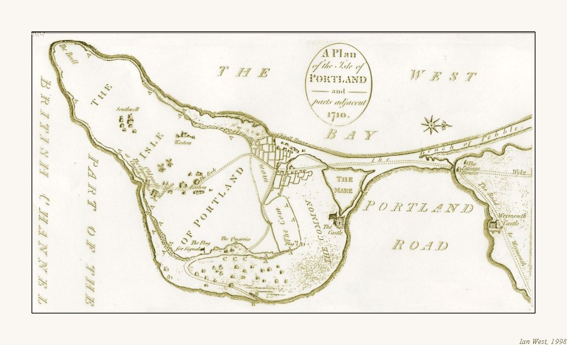
The small but interesting Portland Harbour Beach starts at the ancient Portland Castle, at Castleton, and its original form is shown in on the 18th century map and the 19th century sketch, above. The beach was originally separated from the Chesil Beach at the Portland end by the Mere, a triangular space occupied by a lagoon which became a mud-flat. It is now reclaimed and has been used in the past for oil-storage tanks and as a helicopter port. This lagoon had a small entrance through which the tide gained access. Arkell (1947), referred to some earlier work, (Black, 1878) , who in turn quoted observations of Leland. It appears that early in the 16th century the Mere was continuous with the Fleet, but that the eastward advance of the Chesil Beach has severed the connection and forced the Fleet to find a new outlet at Small Mouth. At a rate of retreat of the order of 15cm per annum, this is reasonably likely since there would have been about another 75 metres between the two beaches and space for a narrow channel from the Fleet to the Mere. At the end of the reclaimed area or former Mere the Portland Harbour beach runs northward separated from the Chesil Beach by the road (and in the past - the railway). It diverges northward and ends at Small Mouth.
It is surprising that the composition of the beach is in contrast to that of the Chesil Beach (Arkell, 1947) and they never mingle. The stones composing it are almost entirely subangular or angular pieces of Portland and Purbeck limestones and cherts from the east cliffs of the Island. Relatively recently there has been much contamination by human activities and the supply material from the east coast of Portland has been cut off by the construction of the breakwater.
TOPIC:
Kimmeridge Oil Shale Fire - the ancient "Portland Volcano"

The Kimmeridge Coal or oil shale crops out beneath loose stone and rubble between tide marks off Castleton (Strahan, 1898) . The bed was recorded as 25cm (10 inches) thick and used to be dug for fuel at one time. It was dug
"especially eastwardes of Her Majesties Castill"
in 1594 (Arkell, 1947) .
Later, in the 19th century, it was quarried for chemical treatment
(Damon, 1884)
There seems to have been a major oil-shale fire in the past in this material, somewhere on the west side of Portland Harbour. Red-burnt shale, appearing like red tiles, can still be found in Portland Harbour Beach south of Small Mouth in the region near the Chesil Beach Centre. It was originally reported to be present at Small Mouth by Buckland and De la Beche in 1836 (or 1837?).
"At a point near Portland Ferry, extending over many yards of the shore, Dr Buckland remembers to have seen, several years ago, a portion of the Kimmeridge clay, which is now covered up with sand, and which at that time presented the appearance of slate burnt to the condition of red tiles; we have now strong reason to presume that such combustion may have taken place, since we have at this moment before our eyes the pseudovolcanic phenomena that are exhibiting themselves in the same stratum of Kimmeridge Clay near the east extremity of Ringstead Bay, at Holworth Cliff, adjacent to the promontory of White Nore..."
[continues re Burning Cliff, Ringstead].
An outcrop on the shore of Portland Harbour was reported by Damon (1884). He stated (p. 78) that:
"A bed of the shale presenting the appearance of burnt tile is exposed at extreme low water on the shore at Portland, near the Castle and extending to the north side of the Chesil Beach from which the bituminous parts have been exhausted or burnt out. This altered character resembles the condition which was presented in the cliff at Ringstead, after the memorable combustion that occurred in the year 1826. As the shale could not have ignited without oxygen, no explanation appears more probable than that the bed in question must at one time have been above the level of the sea. The fossils found in this singular bed are similar to those of the paper-shales at Ringstead, compressed Ammonites, Discina, Cardium, Astarte, Lucina, Pecten etc., though not always distinguishable."
A problem here is that, although the descriptions of the burnt shale resemble that which is visible at present near the Chesil Beach Centre, the two locations given seem to be different. Does "near Portland Ferry" (of Buckland and De La Beche) mean near Ferry Bridge or does it refer to the present landing point at Portland Castle for the boat from Weymouth. If the latter is the case the two descriptions agree. If not there were two separate locations of oil-shale fires on Portland Harbour. It should be noted that a northern locality near Ferry Bridge seems too far north for the oil shale outcrop, which was actually worked at one time on the Isle of Portland. I am inclined to think that Damon's description is valid, and Buckland had once seen a part of this relatively large outcrop.
The outcrop extending from the Castle to the Chesil Beach, desribed by Damon seems to have been the remains of a much larger natural fire than that at Burning Cliff, or Kimmeridge more recently. It was probably the largest oil shale fire on the Dorset coast of which there is any trace. It is a pity that the date of the fire is not known. Apart, of course, from being above sea-level, they are normally in a cliff with some landsliding or collapse. To have had a sufficiently low sea-level for this to have been the case, the fire could hardly have been much younger than Neolithic (round about 4000 years ago) and could even have been late Pleistocene (Devensian - before 10,000 years BP).

.
Where exactly was the ancient oil shale fire of Portland?
Perhaps the fire was connected with landslipping on an old cliff-line on the northwest end of the Isle of Portland. Did the burnt shale extend from near the Castle towards Chiswell? Borehole information might shed more light on this.
A further topic is possible Roman use of the burnt Kimmeridge shale and mudstone in Portland Harbour. The Romans made much use of Kimmeridge oil shale of Kimmeridge for armlets and various ornamental use. They also used the Kimmeridge dolomite beds of Kimmeridge (see the Kimeridge Bay webpage for more information. Whether they worked oil shale at Portland is not known but it is quite possible (it was exposed in the area of the former naval port and a sea-level more than 2 metres lower than today and a small natural cliff would have facilitated quarrying).
At the top of this section is an image showing a comparison with red-burnt Kimmeridge mudstone much used by the Romans for Opus Sectile (a type of ornamental flooring tile in mosaics, and usually cut into triangles) at Fishbourne Roman Palace. The Roman material is remarkably similar and with similar fossil content. It does not so closely resemble the cliff-fire material which is visible at present at Clavell's Hard east of Kimmeridge Bay. It seems probable that the Romans used the burnt mudstone associated with the oil shale here at the Isle of Portland. More work on this is being undertaken by my geoarchaeological friend Pari White. She is preparing a report for Birkbeck College.
Not far from Portland, on the other side of Weymouth, is a Roman Villa at Preston, adjacent to the Roman Temple at Jordan Hill. Here Damon (1884, p. 62) noted that "portions of a chequered pavement formed of black and white tesserae were found, the former being apparently derived from the Kimeridge [old spelling] Shale, the latter from the limestone of the District." It is most likely that this oil shale came from Kimmeridge itself, but a source at Ringstead or even Portland is possible.
For more information on oil shale fires please see the Burning Cliff website .
Acknowledgements
I am very grateful to Pari White for help with geoarchaeological matters. David Rudkin, Director of the Fishbourne Roman Palace, was very helpful and kindly provided access to Roman Opus Sectile and other material.
|Home and List of Geology Webpages
|
Copyright
© 2013 Ian West, Catherine West, Tonya Loades and Joanna Bentley. All rights reserved. This is a purely academic website and images and text may not be copied for publication or for use on other webpages or for any commercial activity. A reasonable number of images and some text may be used for non-commercial academic purposes, including field trip handouts, lectures, student projects, dissertations etc, providing source is acknowledged.
Disclaimer:
Geological fieldwork involves some level of risk, which can be reduced by knowledge, experience and appropriate safety precautions. Persons undertaking field work should assess the risk, as far as possible, in accordance with weather, conditions on the day and the type of persons involved. In providing field guides on the Internet no person is advised here to undertake geological field work in any way that might involve them in unreasonable risk from cliffs, ledges, rocks, sea or other causes. Not all places need be visited and the descriptions and photographs here can be used as an alternative to visiting. Individuals and leaders should take appropriate safety precautions, and in bad conditions be prepared to cancell part or all of the field trip if necessary. Permission should be sought for entry into private land and no damage should take place. Attention should be paid to weather warnings, local warnings and danger signs. No liability for death, injury, damage to, or loss of property in connection with a field trip is accepted by providing these websites of geological information. Discussion of geological and geomorphological features, coast erosion, coastal retreat, storm surges etc are given here for academic and educational purposes only. They are not intended for assessment of risk to property or to life. No liability is accepted if this website is used beyond its academic purposes in attempting to determine measures of risk to life or property.

Webpage - written and produced by:
Ian West, M.Sc. Ph.D. F.G.S.
.
at his private address, Romsey, Hampshire, kindly supported by Southampton University,and web-hosted by courtesy of iSolutions of Southampton University. The website does not necessarily represent the views of Southampton University. The website is written privately from home in Romsey, unfunded and with no staff other than the author, but generously and freely published by Southampton University. Field trips shown in photographs do not necessarily have any connection with Southampton University and may have been private or have been run by various organisations.