

and Visiting Scientist at:
Website hosted by courtesy of iSolutions, Southampton University
Faculty of Natural and Environmental Sciences,
Southampton University,
Aerial photographs by courtesy of The Channel Coastal Observatory
Website archived at the
British Library
(You can download this educational site to SurfOffline, WebCopier or similar software to keep a safe permanent offline copy, but note that at present there is periodic updating of the live version.)
.
The Portland Group (Portland Stone etc.)

This is a view eastward from St. Oswald's Bay to Dungy Head, the best place to see the Portland strata in the Lulworth area. The lowest part, the Portland Sand (actually siltstones, shales and dolomite with some sandstone beds) can be seen further on, at the base of the cliffs, round the corner to the east of Dungy Head. It is an interesting place and some ammonites can be found. The location of the image is at the eastern end of St Oswald's Bay with the small Pinion Rocks on the right and larger rocks, including Ball Stone at Dungy Head. The succession at Dungy Head is described below.
Dungy Head - Portland Group
(awaiting additional material)
Dungy Head, is a good location to see the Portland strata. The lowest part, the Portland Sand (actually siltstones, shales and dolomite with some sandstone beds) can be seen further on, at the base of the cliffs, round the corner to the east of Dungy Head. Some ammonites can be found.
The Portland succession in the Lulworth area, particularly with regard to Dungy Head has been described by Arkell (1947), Townson (1975) and House (1993). It can be summarised as follows - in descending sequence:
The Portland Freestone
The Portland Stone (or Winspit Member) is mostly an oolite or ooid grainstone at Dungy Head becoming an ooid packstone east of Lulworth Cove (Townson, 1975).
Portland Cherty Series
The Portland Cherty Series is well seen at Dungy Head and both the upper part or Dancing Ledge Member of Townson (1975) and the lower part, the Dungy Head Member, contains much sponge spicule (Rhaxella ) wackestone, the silica from which has given rise to the chert. Most of the chert is early, as is usually the case; some is late and related to faulting. The conspicuous thin marker bed know as Puffin Ledge (Puffins used to nest on in the Isle of Purbeck) is easily recognised as a thin bed in the middle and is usually characterised by Thallassinoides burrows. Giant ammonites, Titanites occur at about this level.
Portland Sand
(At the top) Fine grained dolomites known as the Black Sandstones and part of the Gad Cliff Member. These contain the ammonite Glaucolithites . (4.1 m)
The Cast Bed with abundant bivalves, also part of the Gad Cliff Member. Glaucolithites occurs here too. (1.4 m).
The Exogyra Beds with Nanogyra nana, the serpulid Glomerula gordialis and Plicatula boisdini . (1.2m). (Notice how similar the facies is to the Upper Greensand facies seen a short distance to the northwest!)
Black siltstones and shales , the Black Nore Member (21.3 m)
For more information on the Portland strata see Arkell (1947) and Townson (1975a). Purbeck Formation of the Lulworth Cove Area - Introduction

Stair Hole, discussed below, provides a sequence throught the Purbeck Formation. It is only about half as thick here as at the type-section at Durlston Bay. Some of the major marker beds are shown here and details of some are discussed further. Abbreviations are as follows: HC - Hard Cockle Member, SC - a pair of beds within the Soft Cockle Member just above a bed of rip-up clasts, CF - Cherty Freshwater Member, CB - the Cinder Bed of the Middle Purbeck Formation. (Phillips' 1964 diagrams are useful and can be compared with this image).


Left: A simplified cross-section through the Purbeck Formation is shown here for the east side of Lulworth Cove. This is based with modifications on a section in Damon (1884) and shows some of the major features of the Purbeck succession. The area south of the fault needs modification now there is a good exposure of a small monocline, one of the Lulworth Crumples in the back of the cliff. The correct interpretation of this would make a good small project for a visiting student party.
Right: Part of this cliff section to the south of the East Over promontory is shown in the photograph. Unfortunately, the southern part of it should be avoided, especially in wet weather. This is because of an accident having happened at the Hard Cockle Overhang in steady rain and particularly now because there is loose rock up on the cliff to the south (a fissure in the Hard Cockle Member high on the cliff that was just visible in 1892 and more obvious in 1910 had opened to about half a metre by 1979. Recently (1997), there has been major movement resulting in a supply of loose rock on the cliff south of the beach ). The northern part, at East Over, could be used for study with caution if weather and tide conditions were appropriate but no one should venture southeast of the Overhang (and particularly not under the overhang or adjacent to southernmost cliff). This should not be a problem from an educational point of view because the basal Purbeck strata which occur here, consisting of the Caps (limestones , so-called because they cap the Portland buildings stones), the Great Dirt Bed and the Broken Beds (evaporite breccia, since calcitised), and are best seen at the Fossil Forest , a short distance further east. At that ledge the cliff slopes back and rock falls are much less of a threat.
(It must be stressed that the cliffs of the cove are in general no more hazardous that usual rock and shale cliffs. It is simply that they are much more studied, much more well-known and much more visited than those of anywhere else elsewhere! It is appropriate, therefore, to inform geologists of cliff details and then from their own experience and knowledge of cliff and weather conditions they should be able to make their own judgements regarding safety and minimise risks.)
The Hard Cockle Member here consists of pelletal and sandy hypersaline lagoonal limestones with Protocardia purbeckensis , a euryhaline cockle. The limestones of the overhang mark the top and beneath are calcareous shales with sand lenses (sand linsen of ripple origin) and some lignitic debris. The Soft Cockle Member, next above largely consists of marls which elsewhere (Worbarrow, Durlston and the Isle of Portland) have evaporites. Insects remains occur in this unit. Higher in the cliff come the Marly Freshwater Member and the obvious Flint Bed of the Cherty Freshwater Member - limestones with chert. The oyster-bearing Cinder Bed in involved in small folds. The Intermarine Member, brackish water Neomiodon limestones are much thinner here than in the Swanage area where they are extensively quarried. Look for the Corbula member; you should see the small bivalve. The Chief Beef Member is obvious from the large veins of fibrous calcite. You will clearly see the brown stained and green Unio Member with a large slab dipping north. This can be a little awkward to scramble along in the tide is in but it is good for student parties to practise taking dip and strike readings. To the north east on the beach look for Unio in the Upper Purbeck strata and for Purbeck marble with Viviparus. With the Unio you will find fish teeth. This is not surprising since the larval forms of Unio live on fish and since the teeth are in some cases those of mollusc-eating fish ( Lepidotus ).
Purbeck Fossils

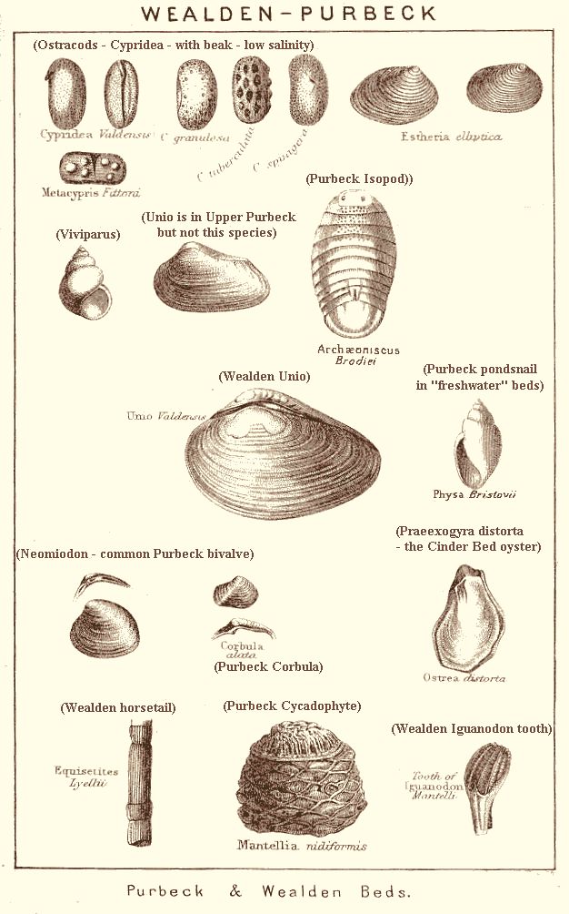
The images here show various common Purbeck invertebrate fossils. The left hand one is modified after Arkell (1947) and the right hand one after Woodward (1907b). For more information on Purbeck fossils see Durlston Bay field guide .
Purbeck Succession in More Detail
The Purbeck Formation at Lulworth Cove is only about 54 m. thick (Bristow in Damon, 1884 and Arkell, 1947 ), compared with about 120 m. at the type section at Durlston Bay, Swanage. The reason for this is that Lulworth Cove is on the edge of the English Channel Inversion (basin that was later uplifted) and the Purbeck facies here is the condensed facies of a branch of the swell or high, not of the basin as at Durlston Bay. This is also the reason why the Fossil Forest and soils are developed here (but note that the same swell facies occurs on northern Portland, a topic it is not necessary to discuss in detail here). The relativfe uplift has resulted in certain parts of the Purbeck succession being absent at Lulworth Cove, particularly the gypsum beds in the Soft Cockle Member.
The Purbeck succession on the east side of Lulworth Cove is summarised below. This is a general introduction, not a bed by bed account, but simply a summary of the main members with some details and some interpretion. It is based on personal observation, a section in Damon (1884), and other sources (some parts of it, particularly the Unio Member need some improvement and modification which will be provided in due course). The Purbeck Formation is divided into a number of easily recognised lithological units (e.g. Cherty Freshwater Beds) which have well-known traditional names dating from the 19th Century. These units are members in modern terminology (divisions of a formation) but the old names, well-established in the literature, are retained with some minor modifications and with the ending " Member " (e.g. Cherty Freshwater Member).
For Purbeck fossils please see Purbeck Fossil Section in the Durlston Bay Web Site
.
Upper Purbeck
UPPER OSTRACOD SHALES MEMBER
(formerly " Upper Cypris Clays and Shales ")
Shales, often pyritic and with some siderite and with glauconitic Viviparus limestone - Purbeck marble, as shown here (but from Peveril Point). This gastropod limestone (a biomicrite with glauconite) was quarried further east and extensively used for carvings in churches before alabaster was used as a replacement. Look for it as narrow projecting beds of rock on the foreshore at the top of the Purbeck succession. Do not be confused by the fact that the Unio Bed occurs within this unit and that Unio is also abundant in the Unio Member beneath. The Unio Bed is a conspicuous greenish bed with " Unio " occurs in association with pyritic shales.contains remarkable liquefaction structures in limestone. Reworked Portland and Kimmeridge detritus occurs in the region at this level and earthquake activity associated with the Late Kimmerian movements may be responsible for the liquefaction (this is very well seen in Stair Hole but it extends to Mupe Bay).The pond-snail Viviparus , the freshwater bivalve Unio ,fish remains( Pycnodus, Lepidotus ) and ostracods such as the beaked freshwater form Cypridea are common in these beds. These beds are of freshwater lacustrine (lake) origin.
4.8 m.

UNIO MEMBER (as used by Damon, 1884)
(Unio Beds) Soft green, glauconitic shale full of Unio porrectus . Viviparus .Bands of hard limestone. " Beef " , shelly limestone and dark grey shales. Damon (based on Bristow) gives too great a thickness for this unit at Lulworth Cove (east side). It is less than 1 metre and directly on top of the Broken Shell Limestone (more detail will be provided on this to resolve the problem and the Lulworth sections compared with those elsewhere). These strata originated in low salinity, lacustrine conditions. The bones of turtles and crocodiles from this lake are preserved at Swanage.
1.14 m.
Middle Purbeck
BROKEN SHELL LIMESTONE MEMBER
Limestone, a biosparrudite probably mainly consisting of Neomiodon debris, with fish teeth, palates and scales (Pycnodus). Gastropods include Viviparus . This is probably mostly of brackish-water origin but the gastropods indicate some very low salinities at times. Limestone (the Burr) from this horizon has been used for the construction of Corfe Castle.
1.06 m.
CHIEF BEEF MEMBER
Dark soft shale with bands of hard shell-limestone (biosparrudite) with Neomiodon. Beef is diagenetic fibrous calcite formed under burial. As usual it is associated with lines of white, disintegrating, aragonitic Neomiodon shells. The organic rich shale here has preserved the aragonite to some extent, although elsewhere in the Purbeck Formation it has mostly been lost quite early. This is a brackish-water lagoon sediment.
2.51 m.
CORBULA MEMBER
Hard limestone covered with fish-spines (Asteracanthus ) - 0.53 m. Shells include Neomiodon , a common bivalve of the Middle Purbeck Formation. The oyster of the Cinder Bed, Praeexogyra distorta also occurs in this unit as does a " Pecten ". This originated in nearly marine salinities.
4.57 m.
SCALLOP MEMBER
Hard shell limestone (biosparrudite?). Usually sandy with Chlamys , a bivalve which probably suggests near-marine salinities. This unit indicates a significant marine incursion. Seawater entered the lagoon on a scale almost like that at the time of deposition of the Cinder Bed.
0.59 m.
INTERMARINE MEMBER
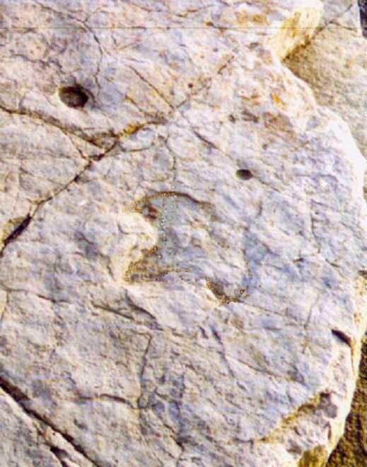 Beds of hard shell-debris (biosparrudite) limestones with about 1 metre of pyritic shales with some beef and jarosite in the central part (" mid-intermarine shales "). The clays are smectite-rich. This is one of the main parts of the Purbeck Formation where dinosaur footprints (shown here with, the image slightly retouched, in the Intermarine Member at Worbarrow) are preserved in extensive damp lagoon-margin flats of shell sediments. In the Swanage area the biosparrudite limestones (El-Shahat and West, 1983) of this form most of the Upper Building Stones, although they do not seem to have been much quarried at Lulworth where they are thinner. The shell beds are composed of debris from the brackish water bivalve Neomiodon . The shells were originally aragonite but have been replaced by calcite now.
This unit originated in a lagoon that had some influx of freshwater but generally remained brackish. The climate was less arid than that in which beds lower in the sequence were formed. This accounts for generally more sand, kaolinite clay, pyrite, plant debris and lower salinities than those indicated for the lower members. The subhumid conditions seem to have been favourable to dinosaurs, crocodiles and turtles.
2.29 m.
CINDER MEMBER

Beds of bluish-grey shelly limestone with small oysters - Praeexogyra distorta (example in image is from Stair Hole). The Soft Cinder, 0.46 m., is more argillaceous and overlies the Hard Cinder (0.76 m.). This conspicuous unit is easily distinguished by its colour and its relative lack of jointing and a tendency to erode to a roughly rounded surface (unlike the blocky Flint Bed a little further down). Look for rare echinoid spines ( Hemicidaris purbeckensis ) in the Hard Cinder which show that conditions were normal marine for a short time. Difficult to see are bivalves which unlike the calcitic oyster were originally aragonitic. Diagenesis has rendered part of the original shell content almost invisible.
This bed has been taken as the Jurassic-Cretaceous boundary (in some older text-books you may find this listed as the boundary)but there are problems with this. It may well correlate with the Jurassic-Cretaceous boundary in the Boreal Realm, that is the northern and Russian region, but not with the (now official) Jurassic-Cretaceous boundary of the south of France. The boundary is now believed to be near the base of the Purbeck Formation which is regarded as mostly Cretaceous. Nevertheless, the Cinder Bed is a very extensive and useful marker for the middle part of the Purbeck Formation.
This bed indicates an incursion of the sea into the lagoon. It is the result of a brief marine transgression. In the shallow environment the water became just about marine enough for echinoids ( Hemicidaris purbeckensis ), but not for long. The marine conditions were not stable for long enough for ammonites to live in this area. The small oyster could tolerate lower salinities than truely marine and still flourished when the water became rather brackish. This was not the only marine incursion; there were about 37 others at least during deposition of the Purbeck Formation.
1.22 m.
CHERTY FRESHWATER MEMBER


Dark sandy shales 0.6 m. at the top overlie the Flint Bed, a conspicuous, creamy white, blocky, micritic limestone with chert nodule. It is shown here on the left at the type section at Durlston Bay and on the right at Stair Hole (with the Cinder Bed) where it is thinner. Three distinct layers of chert occur in this. Further east the upper shales contain mammal remains and fragments of dinosaur eggs. The Flint Bed (0.68 m. thick at Stair Hole) contains freshwater gastropods, ostracods and charophyte algae. Although the fauna is of very low salinity origin, drying out of the sediment in summer has resulted in the formation of salt cubes within it which have been replaced by silica. Look for well-preserved ostracods, including " Cypridea " in the shales. These are the deposits of an isolated lake rather than a lagoon.
1.75 m.
MARLY FRESHWATER MEMBER
Bluish shales with beds of marlstone and argillaceous limestone, 0.6 m. Towards the centre a bed , 0.76 m. thick, of pale pink and variegated compact limestone, rather abundant in scales etc. of fish - Lepidotus ; shells - Hydrobia, Physa, Viviparus etc. The Mammal Bed occurs in this unit at Durlston Bay.
3.81 m.
Lower Purbeck
SOFT COCKLE MEMBER
The Soft Cockle Member consists predominantly of soft marls and marlstones, usually with signs of evaporites and with the common Purbeck cockle shell - Protocardia purbeckensis . Protocardia was a euryhaline bivalve occupying the ecological niche of the modern euryhaline cockle - Cardium glaucum or Cerastoderma glaucum. As the very tolerant modern cockle does in Egypt (West, 1985) it could live in hypersaline lakes and lagoons if salinities were not too extreme.
At the top hard and soft marls occasionally becoming hard enough to form argillaceous limestones - 2.13 m. Pale grey limestone or dolomite with shaly partings. Pseudomorphs and moulds after halite are found in this. Equivalent beds to the east usually prove to be dolomite although the bed has not been investigated here, as yet. Thickness of this unit 1.06 m. Dark shales and limestone beds with alternating shaly limestone and clay at the base. Damon refers to the lower part covered with small pebbles (mudclasts?). Two species of ostracods and fish remains are present and there are more pseudomorphs after halite. Thickness of this unit - 3.96 m. Hard and soft marls; grey shales and limestone beds. At the base hard marlstone with cavities lined with silica and calcite. These are the relics of evaporites.
 Note that the main secondary gypsum bed of Worbarrow Tout (Ensom, 1985), the enterolithic veins of which are shown here, and which also occurs at Durlston Bay (Clements, 1993) is absent at Lulworth Cove in the thinned sequence. It normally occurs near the base of the Soft Cockle Member. Insect remains occur in fine-grained dolomites with pseudomorphs after halite and are probably present here too.
Thickness - 11.89 m.
HARD COCKLE MEMBER
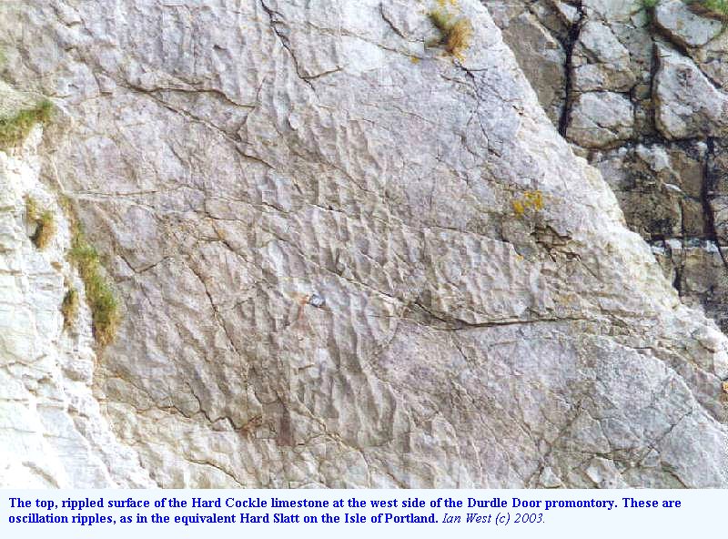 This consists of hard, sandy, yellowish limestone above dark sandy shales. It contain abundant Protocardia purbeckensis in some cases forming shelly limestone. It is often ripple-marked (as seen here at Durdle Cove) with oscillation ripples and ripple bedded and contains pseudomorphs after halite. The limestone in the upper part is always conspicuous in the cliffs forming a projecting ledge. The contrast with the Soft Cockle Member is great so that this unit is easy to find. The base is not so obvious because the rather similar " Cypris " Freestone Member lies beneath.
Details: At the top is hard fissile limestone with thin layers of coarsely-crystalline, honeycombed limestone and a shaly parting, 1.21 m. Yellow sandy limestone, very conspicuous from its colour, and mode of weathering; ripple marks on under surface, 0.6 m. Shelly limestones (Protocardia biosparrudites) 1.83 m. Dark sandy shale, usually with sand linsen structures, 0.60 m.
This is a hypersaline lagoonal deposit. Salinities were probably about twice seawater for much of the time. There was significant small wave activity and accumulation of lagoonal shell banks and sand in the shallows of the Lulworth area. At time minor evaporites were precipitated.
4.26 m.
" CYPRIS " FREESTONES MEMBER
Soft, ripple-laminated, pelletal limestone with abundant ostracods and minute fragments of plant debris. Usually pale yellowish weathering and with ripple-bedding. Ostracods include Mantelliana purbeckensis . Gastropods including Hydrobia and Valvata and the isopod Archaeoniscus brodiei occur in this unit elsewhere and should be looked for. There are minor evaporites.
Details:
At the top: Soft laminated limestone. Faecal pellet and other sediment moulds of halite crystals. Ostracods and gastropods (reported by Damon, 1884). ).76 m.
Very sandy limestones with casts of fossils. ) 0.91 m.
Shales and limestones with cream-coloured laminated limestone at the bottom. The exact base is variable as the Broken Beds breccia below incorporates the basal part of this unit to varying extents. 1.52 m.
The " Cypris " Freestone Member has a fauna and evaporitic sediments compatible with an origin in a moderately hypersaline lagoon, probably mostly about twice seawater salinity (about 50 to 70 parts per thousand, but variable from winter to summer in the very seasonal Purbeck climate). The water was very shallow, with carbonate sand flats often drying out. Winds from various directions rippled the shallow salty water and sediments. In spite of the shallow conditions footprints are rare. Dinosaurs did not often walk over this, probably because the saline water was unattractive to them.
6.40 m.
THE BROKEN BEDS MEMBER


This is a conspicuous limestone breccia of varying thickness, usually divisible into two distinct parts, the upper of angular limestone blocks, the lower of limestone blocks in soft calcitised anhydrite matrix.
The Upper Broken Beds are easily recognised by consisting of angular blocks of ripple-laminated limestone with no significant matrix (other than small broken blocks) between them. No chert occurs in this and there is no evidence that major evaporites were present in this part.
The Lower Broken Beds have much of the soft matrix which superficially resembles soft sandstone. It is porous calcitised anyhyrite which under the microscope shows pseudomorphs after anhydrite and the form of silica so often associated with evaporites - lutecite. Euhedral quartz crystals occur in places but some of the best evidence of evaporites comes from the chert. This consists of pseudomorphs after primary lenticular crystals of gypsum (if not immediately visible in a thin-section try a light etching with hydrofluoric acid - with care!). More lithified blocks of calcitised anhydrite occur in a matrix of soft calcitised anhydrite, indicating more than one date of calcitisation. For more details see West (1964; 1975). Calcitisation has been studied in term of stable isotopes and meteoric water seems to have been involved in this western area of the Broken Beds, whereas further east hydrocarbons were involved in the diagenesis.
This evaporite horizon thickens eastward and continues under southeast England. Anydrite, for example, occur in the Arreton Borehole in the Isle of Wight and is also present at this horizon at Portsdown, in the Southampton area (Hoe No. 1) and elsewhere. Where the anhydrite is hydrated back to secondary gypsum near the surface at Brightling and Mountfield in Sussed, there is mining of it by British Gypsum for plaster and plasterboard.
The breccia has been brecciated tectonically, frequently fracturing the chert. The date of movement of the overlying strata to the north (the direction is shown by folds within the Broken Beds) is either intra-Cretaceous or Tertiary but not yet firmly established.
The lower Broken Beds originated as gypsum in a hypersaline lagoon at salinities of about 124 parts per thousand. The environment was semi-arid at a latitute of about 37 degrees north.
3m (but variable)
(For further information see the Broken Beds section of the Fossil Forest Field Guide. ) .
SOFT CAP BED (PART OF CAPS MEMBER)
 Limestone mostly unbrecciated above the fossil trees in the Great Dirt Bed. It consist of two parts. The upper bed is of calcitised anhydrite, showing some features of the primary gypsum bed, including algal and ripple lamination. The lower part, which still have some association with evaporites, consists of stromatolitic limestone with small tubes, encrusting tree remains. Like the modern stromatolites of Shark Bay, Western Australia it was presumably formed by cyanobacteria. Carbonate precipitated on these occurs below, as well as above, projecting tree remains. There is no freshwater fauna associated but evaporites can be found in thin-section under the microscope showing that this limestone originated in hypersaline conditions.
1.52 m.
. THE GREAT DIRT BED
Rendzina (carbonate-rich) soil with limestone pebbles. The fossil trees are rooted in this. You might think that this would be a good place to find late Jurassic spores and pollen but this is not the case. The soil was significantly weathered but not in acid conditions so as to destroy the limestone pebbles. The pebbles are from limestone like that underneath and not from a distant origin (there is a record of one granite pebble having been found and preserved in the British Geological Survey Museum!). The pebbles are not even from the Portland Stone, although the Portland Group contributes detritus to the Wealden strata, higher in the sequence. The soil contains anomalously high strontium and has other peculiarities, including black pebbles (see papers of Francis for further details).
0.15 m. (but variable)
. HARD CAP (PART OF THE CAPS MEMBER)
Fine grained, laminated, oolitic and pelletoidal limestone with large stromatolites (2 to 3 metres). Gypsum crystals have formed the nuclei of some ooids, showing that the water was saturated for gypsum (about 124 parts per thousand salinity). As in Shark Bay the stromatolites have formed in hypersaline water that was preventing their destruction by browsing gastropods. The top of the Hard Cap has Tepee structures, polygonal cracks containing pisolites. This bed was, of course, lithified before formation of the Great Dirt Bed so that pebbles of it are incorporated in that deposit.
A thin lower dirt bed separates this from the top of the Portland Stone. Strangely, halite pseudomorphs occur in the top Portland Stone at Bacon Hole, nearby. There has been some erosion of the Portland limestone in the Lulworth area and minor development of caliche at the top.
1.37 m. (Hard Cap and Lower Dirt Bed)
.
Some Specific Purbeck Features

Here at East Over on the east side of Lulworth Cove is a small syncline and anticline in the Middle Purbeck Formation. You can examine this well on the shore at low tide (but be careful of slippery algal-covered rocks!). The marker horizon here is the Purbeck Cinder Bed, blue grey in colour with small, bluish-black oysters.
Under the Cinder Bed, find the white Cherty Freshwater Limestone. It is important for containing pulmoniferous (air-breathing) gastropods (pond-snails). The best place to find these is not here but on the coast between Durlston Head and St Albans Head.
The gastropods caused some interest in the 19th Century because arguments about special creation rather than evolution were still taking place in Europe. Professor Edward Forbes, a famous geologist, conchologist and botanist and researcher on the Purbecks wrote the following humorous verses:
"Down among the Purbecks deep enough,
A Physa and Planorbis
Were grubbed last year out of fresh-water stuff,
By Bristow and E. Forbes
(Agassiz has just given his bail,
'Twas adverse to creation,
That there should live pulmoniferous snail,
Before the chalk formation.) "
In the Middle Purbecks, below the Cinder Bed in the low cliff of the promontory just here is a good ostracod-bearing shale with the low-salinity, beaked ostracod Cypridea, a genus used for zoning the Purbeck Formation.


In the Unio Bed of the Upper Purbeck Formation freshwater gastropods (Viviparus)and the freshwater bivalve Unio porrectus are common in glauconitic limestone of lacustrine origin. On the right are modern analogues. The presence of glauconite in the freshwater Upper Purbecks has long been discussed (informally) as something of a mystery. It normally occurs in marine strata. The difficulty of understanding it here is that there is reworked glauconite and other material from the marine Portland Group at this horizon. There is also authigenic glauconite that colours the carbonate and occurs within shells. Separating the two is difficult and conclusions cannot simply be drawn on study of the bulk glauconite that can be obtained by acid-digestion of the limestone.

Beef is a form of fibrous calcite that is common in organic-rich shales (El-Shahat and West, 1983 ). It is a diagenetic product with cone-in-cone structure. It has usually formed by the dissolution of aragonitic shells in the presence of organic matters under a kilometre or more of burial (Marshall, 1982 ). The calcite grow against the maximum stress. It has a similarity to satin-spar in gypsum (you can see this at Worbarrow Tout, further east) but, of course, you cannot scratch the harder beef with the finger nail. This example is from the Chief Beef Member of Dungy Head and is in grey, organic-rich, shale (see El-Shahat, 1977 for analyses of similar material at Durlston Bay). The name is a quarryman's' term for the thinner veins which resemble the cut slices of muscle.
Beef is usually present as thin veins, half a centimetre thick or less, and parallel to bedding, but with fibres normal to bedding. It can be seen in the Chief Beef Member of the Purbeck Formation at many localities. It also occurs in the organic-rich Shales with Beef in the Dorset Lias and also in the Carboniferous Coal Measures of Britain. A remarkable feature of the Lulworth Cove area is that veins of beef in the Middle Purbeck Formation can attain 15 cm in thickness, very unusual elsewhere. This is presumably related in some way to the high stress that this area, near the foresyncline of the Purbeck Monocline, has been subjected.

A shoot from a Purbeck tree. The specimen, from the Day Collection at Southampton University, is from a sandy limestone of the Purbeck Formation of Lulworth Cove. It is not known from which part of the formation or where, exactly, it was found in the cove.
The small block of limestone contains bivalve shells, possibly Neomiodon and a minute vertebrate tooth. Dispersed through the limestone is quartz sand, and this is visible in the photograph. The horizon is not known but I would expect it to have been Middle or Upper Purbeck, rather than lower (which has finer-grained limestones usually lacking in teeth). Francis (1983) has described a rather similar shoot from the basal Purbeck of the Isle of Portland, and some similar features can be seen in this. ' Branches arise alternately at every node on the main stem and minor branchlets, but appear to be arranged in opposition on the ultimate shoots. Alternate branchlets are either straight or slightly curved. The main laterals subtend an angle of about 45 degrees to the main stem and subsequent branches subtend an angle of about 55 degrees. The whole shoot is now strongly compressed and bears small leaves in an opposite and decussate arrangement strongly reminiscent of modern Cupressaceae, such as for example, Thuja plicata D. Don.'
.
WEALDEN GROUP - Lulworth Cove
The Wealden strata consist of mottled clays, reddish, pink, yellow, purple and brown with some beds of sandstone. Lignite, fossil wood, occurs quite commonly. The Wealden strata are famous for dinosaur remains, most of which are found on the Isle of Wight .
The Wealden succession has been drastically reduced in thickness in the Lulworth area. Only 48 m. are left at Dungy Head from a succession that measures 701 m. at Swanage and 428 m. at Worbarrow Bay. Thinning and unconformity are probably major factors in this area which was structurally high in Cretaceous times, before the formation of the English Channel Inversion. Strike faulting is probably a major factor and the Wealden strata at Dungy Head are very much sheared.
At Lulworth Cove the Wealden succession is 166 m. thick. The Coarse Quartz Grit, 4.3 m. thick at the cove is a conspicuous marker horizon in about the middle of the Wealden succession. It projects in the cliff and forms a ridge in the Wealden valley between the Purbecks and the Chalk .


Left: The Wealden Group consists of red, yellow, purple and brown clays with beds of sandstone, in some cases very coarse. The clays have been used for brick-making, here, on the east side of Lulworth Cove.
Right: Jarosite on pyritic Wealden argillaceous sand near Dungy Head. Oxidation of the iron sulphide pyrite can produce sulphuric acid and iron oxides. Reactions lead to the formation of the hydrated iron-bearing sulphate jarosite (with either sodium, potassium or ammonium). This yellow surface encrustation is often mistakenly referred to in old literature as " sulphur ". It is slowly soluble in water and is washed away to some extent by heavy rain but develops again in fairly dry weather. An interesting curiosity of the Lulworth area is that potassium jarosite has been found on a Wealden oil-sand from the east side of the cove (Parker, 1972). Whereas natrojarosite, which contains sodium, is common on the coast as a result of sea-spray supplying sodium, the source of the potassium is rather puzzling. Parker attributed it to alteration of orthoclase within the Wealden, although this is not a mineral likely to have been transported here in any abundance.
.
The Lower Greensand
The Lower Greensand is very poorly developed at Lulworth Cove partly because of general westward overstepping and because this was a swell or relative uplift area in mid Cretaceous times (because of Late Kimmerian movements). Arkell (1947) noted that on the east of Lulworth Cove, about 30 cm below the pebble bed at the base of the Gault, from which it is separated by a sandy clay, is a 15 cm band of impersistent ironstone. He referred to this as a limestone when unweathered (siderite?), containing badly preserved fossils. Strahan (1898) recorded " Cyrena, Exogyra, and a few gastropods " and assigned these beds to the Wealden. The Exogyra may be Exogyra tuberculifera common in the Lower Greensand at Punfield Cove near Swanage. The shelly stone band resembles fossiliferous ironstones of Worbarrow Bay Arkell (1947). Below the fossil bed are about 1.5 metres of dark grey shaly clay, resting on white and sand (5 metres). The age of these is uncertain. The Lower Greensand is overstepped to the west of here but eastward it thickens to 25 metres at Worbarrow Bay and 61 metres at Swanage.
.
Gault Clay


The Gault is a blue-grey clay which is of marine origin and contain marine gastropods, bivalves and ammonite. Unfortunately, it is prone to cause landslides and because of this is known as the "Blue Slipper" in the Isle of Wight, where it causes serious problems. Here, in the Lulworth area it causes small landslides and not large ones because the strata are almost vertical and it does not lie under large units of Upper Greensand and Chalk. In the cliffs it is usually much weathered and good fossils are difficult to find as a consequence. It has a distinctive pebble bed at its base and at its top it becomes sandy and passes transitionally up into the Upper Greensand.
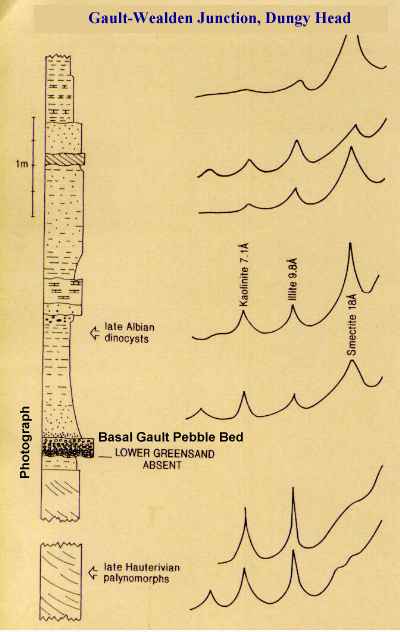
The Gault - Wealden junction at Dungy Head is shown in the photograph, with alongside it a section also showing a drastic change in clay mineralogy. The pebbles are subrounded and consist of resistant material such as lydite (black Palaeozoic chert) and vein quartz. They represent a marine beach which was the start of a marine transgression over the fluvial Wealden sediments. The smectite clays are common features of marine sediments in this region but the Wealden sediments beneath usually lack such clays because of acid soil conditions but kaolinite and illite are stable. The plastic, expandible smectite clays are a major factor in the behaviour of this unit as a cause of landslides.
In terms of palaeoenvironments the marine transgression which the Gault represents is a major one, over the Wealden fluvial clastics. There is a major unconformity at the base of the Gault. It is not clearly visible here but it is at White Nothe, not far to the west. The compositions of the pebbles reflect the rocks eroded by the Gault sea.


The Upper Greensand, about 40 metres thick in this area, consists of calcite-cemented glauconitic sand and sandstone with marine fossils, like those shown here. Molluscs are common. It has undergone some diagenesis and as a result ammonites with their aragonitic shells are mostly preserved as either internal moulds of sandstone or more frequently as phosphate moulds in certain phosphatic horizons. Chert beds (brown chert nodules in sandstone) occur in the upper part of the sequence. The silica for the chert has come from abundant sponges on the fairly shallow sea floor. At the top is an obvious and very peculiar boulder bed of clasts with glauconite coatings. The Upper Greensand facies are unusual here because of a swell, condensed sequences and penecontemporaneous erosion (Drummond, 1970). The lithological unit is mostly Albian in age.

Calcite-cemented glauconitic sandstone of the Exogyra Rock which occurs in the middle of the succession. This bed is conspicuous because it projects in the cliffs and is full of fossils, particularly Exogyra obliquata (Pulteney). In older literature this is referred to as Exogyra conica (J. Sowerby). Although elsewhere in Dorset it is almost 3 metres thick, in the Lulworth area it only about a metre It contains Pecten (scallop) bivalves of which you can see a part in the image. Small echinoids ( Caratomus, Salenia, Hyposalenia, Discoidea ) are fairly common in good exposures where there has not been too heavy collecting. This bed occurs near the entrance to Lulworth Cove and easily accessible fossils have gone. You can look up, though, and see the Exogyras (Palaeontological specialists should look at other sections , which I will not name here for obvious reasons!). There are three argillaceous beds above each of about a metre thickness, of which the top one is the Ammonite Bed (see Arkell, 1947, p. 190 for summary faunal list). Large nautili occur in the bed beneath it.
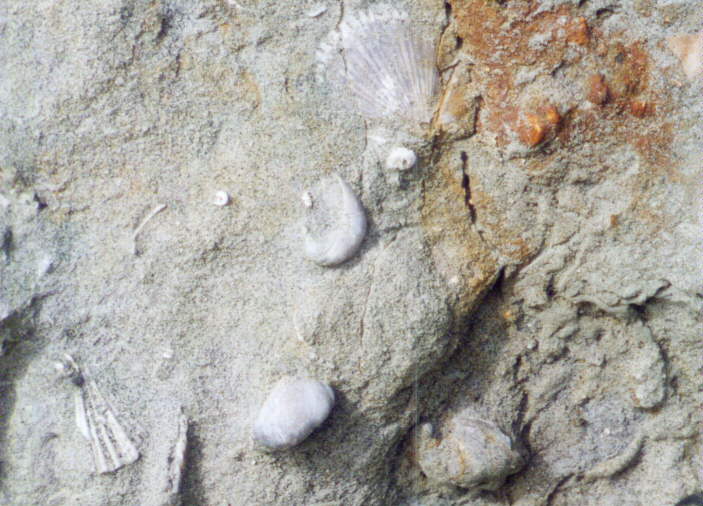
Aequipecten aspera (Lamarck) (Pecten asper in older books), a very common scallop (a " sea-butterfly " because of the behaviour mentioned below) of the Upper Greensand with Exogyra obliquata (Pulteney) and some other shell material including serpulid worm tubes Rotularia concava (J. Sowerby).

Entolium orbiculare (J. Sowerby), another common member of the Pecten family in the Upper Greensand. This small specimen (about 5 cm) is not perfect because the " ears " are not visible. Perhaps, this small scallop and Aequipecten asper were able to swim as many modern scallops do by flapping their valves and thus avoiding being buried in the sand (until final fossilisation!). Relatives of this mollusc at the present day have a number of small eyes in the edge of the mantle, useful for these more active members of the Bivalvia.
The dark dots in the image are glauconite grains. These are sand-sized, ovoid or spherical aggregates of dark green, iron-bearing clay minerals there are smectite, illite and mixed-layer varieties so the broad term " glaucony " is sometimes used by specialists to refer to a green glauconite-type mineral of unspecified clay mineral composition ). The mineral contains both ferrous and ferric iron in glauconite and the implication of this is that it has been formed at the oxic/anoxic boundary (i.e. with normal oxygenated water above reduced sediments). The rounding of the grains is a result of current or wave activity, also shown by the presence of quartz sand. Sea-floor conditions were probably rather like those of the current swept English Channel at the present day, but warmer.
It is puzzling as to exactly why glauconite was so abundant in southern England at this time, although the shallow current-swept sea-floor was clearly a factor. The same facies reappears in the Middle Eocene Bracklesham Group of Hampshire and Isle of Wight, where there are greensands with similar bivalve shells Amusium corneum.
The Lower Chalk
The Lower Chalk, of Cenomanian age, consists of cyclical, alternating marly chalk and harder purer chalk. It is shown in the illustration looking east (along strike) on the eastern side of Man-o'-War Head (near Man-o'-War Rock, east of the Durdle Door promontory). Note that flint is generally absent and the bedding is very clearly visible. The softer marly beds, much burrowed, have been eroded out by the sea. The area covered by shallow water on the landward side to the left (to the north) consists partly of the relatively soft Plenus Marl, 2 or 3 metres thick. This is a conspicuous marker and useful line of division between Lower and Middle Chalk in the cliffs but its characteristic belemnite, Actinocamax plenus, is not often seen. You might find the echinoderm remains (Crateraster quinqueloba ) which can occur in this bed in Dorset (Arkell, 1947). Usually, though, it seems rather barren.
This part of the Chalk is easily recognised at Lulworth Cove and elsewhere in the region. It can attain a thickness of 57 metres in Dorset but in the Lulworth area it is greatly reduced by strike faulting, although this may not be obvious at first sight. It is only 10 metres thick in Lulworth Cove and even less in the Durdle Door area. Look for the basement bed with small brown phosphate nodules and some glauconite grains and then note above this clearly banded and burrowed chalk. It can be clearly seen on the foreshore at Lulworth Cove when the tide is out. Ammonites ( Calycoceras and Mantelliceras ) and sponge remains occur in the Lower Chalk but good examples are not commonly found in this particular (much tectonised) area.

Fossils from the basement bed of the Lower Chalk. These specimens come from White Nothe but imperfect examples of some of these might be found in the less favourable exposures of the Lulworth Cove area. A - Holaster subglobosus Dixon, B - Scaphites aequalis Sowerby, C - Turrilites costatus Lamarck, D - Schloenbachia varians (J. Sowerby). This basement bed has a rich fauna with other cephalopods such Mantelliceras, Calycoceras and Cyrtocheilus and many other fossils, including numerous terebratulids. The Holaster pavement for which it is notable elsewhere is not usually seen near Lulworth Cove but broken examples of Holaster can be found.

Above is a selection of some more Chalk fossils. Only certain of these can found in the main sequence of Chalk in the Lulworth Cove area and they are rarely good specimens. Because of the shearing and lithification it is not usual to find complete echinoids. Careful search may reveal remains of some of the specimens shown, especially if they are small or preserved as fragments.
.
MIDDLE CHALK

The Middle Chalk in this area is very nodular. This is the result of early cementation on the sea floor. The example of nodular chalk shown here is a sea-eroded fallen block from St. Oswalds Bay. It is grey and marly and contains some flint. This may suggest, however, that it does not come not from the Middle Chalk but from the Holaster planus zone of the Turonian Stage, that is the lowermost part of the Upper Chalk. The Middle Chalk nodules are similar to these, though. For a very interesting and informative paper on nodular chalk and hardgrounds see Kennedy and Garrison (1975).
The Upper Chalk
The Upper Chalk is relatively pure calcium carbonate and is characterised by containing flints. It forms the greatest part of the Chalk succession. In this area, though erosion may have removed more than is usual from the top before deposition of the Tertiary strata. The Upper Chalk is more lithified and harder than usual in this region because of tectonic action.
Copyright
© 2013 Ian West, Catherine West, Tonya Loades and Joanna Bentley. All rights reserved. This is a purely academic website and images and text may not be copied for publication or for use on other webpages or for any commercial activity. A reasonable number of images and some text may be used for non-commercial academic purposes, including field trip handouts, lectures, student projects, dissertations etc, providing source is acknowledged. No permission can be given for reproduction of any images of the Lulworth Cove area in books or in other websites, for special reasons.
Disclaimer:
Geological fieldwork involves some level of risk, which can be reduced by knowledge, experience and appropriate safety precautions. Persons undertaking field work should assess the risk, as far as possible, in accordance with weather, conditions on the day and the type of persons involved. In providing field guides on the Internet no person is advised here to undertake geological field work in any way that might involve them in unreasonable risk from cliffs, ledges, rocks, sea or other causes. Not all places need be visited and the descriptions and photographs here can be used as an alternative to visiting. Individuals and leaders should take appropriate safety precautions, and in bad conditions be prepared to cancell part or all of the field trip if necessary. Permission should be sought for entry into private land and no damage should take place. Attention should be paid to weather warnings, local warnings and danger signs. No liability for death, injury, damage to, or loss of property in connection with a field trip is accepted by providing these websites of geological information. Discussion of geological and geomorphological features, coast erosion, coastal retreat, storm surges etc are given here for academic and educational purposes only. They are not intended for assessment of risk to property or to life. No liability is accepted if this website is used beyond its academic purposes in attempting to determine measures of risk to life or property.

Webpage - written and produced by:
.
Ian West, M.Sc. Ph.D. F.G.S.