
Website hosted by courtesy of Information Systems Services, Southampton University
Southampton Water with Hythe Pier and the Hythe Ferry seen from the new marina northwest of Hythe. Here Bracklesham (Eocene) glauconitic sands and carbonaceous clays, together with Pleistocene gravel and Holocene mud have been dredged from the main channel of the estuary, in the 1960s, and dumped here to reclaim the mudflats for housing. The artificial shore is protected by blocks of shelly and oolitic Portland Stone and stromatolitic limestone from the Purbeck Formation.
School of Ocean and Earth Science ,
National Oceanography Centre, Southampton
Southampton University,
|Home & Contents
|Field Guide Maps and Introduction
|Solent Geology Bibliography - General, Undivided
|Solent Geology Bibliography - Topics, Alphabetically
|Isle of Wight Introduction
|Isle of Wight Bibliography
|Solent - Lepe Beach and Stone Point
|Whitecliff Bay, Isle of Wight
|Alum Bay, Isle of Wight
|Neolithic Peat at Fawley
.

.
This is an old field trip guide. Please go to newer versions
|
Browndown
Cowes Gilkicker Point Hill Head |
Lee-on-the-Solent
Lymington Newtown Estuary Osborne House Pennington Marshes |
West Solent
Wootton Creek |


.
Coast Northwest of Hill Head
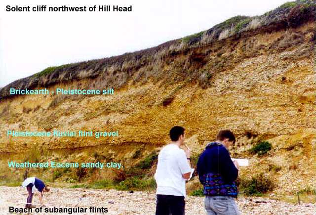
Low cliffs have been eroded on some north-eastern shores of the estuarine system where there is much exposure to waves driven by the prevailing south-westerly winds. Here is a good section in the Pleistocene periglacial river gravels northwest of Hill Head near Lee-on-the-Solent.
The gravels overlie Middle Eocene, Bracklesham Group (Selsey Formation). This consists here of marine sandy clays with abundant glauconite weathered to brown at the surface. It is much bioturbated, with some poorly preserved moulds of marine molluscs. Large fossiliferous calcareous nodules occur in the Bracklesham strata in the subsurface and weathered rotted examples can be found in the cliffs here.
The Pleistocene gravels are similar to others at higher levels and to gravels occurring under the estuary. Subangular flint pebbles are dominant but there are also present some rounded pebbles with percussion marks that are derived from the Eocene strata. Scattered reddened flint pebbles are probably the result of fires on the tundra (or human activity). Occasional sarsen stones occur. The gravels, which are of seasonal braided river origin, show scours and cross-bedding and the effects of cryoturbation and there are ice-wedge casts. Brickearth at the top is a silt deposit which in this area has clay minerals suggesting at least partial derivation from nearby Chalk outcrops.
.
Browndown
 Browndown and Gilkicker Point where the southeast end of Southampton Water meets the Solent. The relatively bare ground of Browndown consists of accumulations of gravel transported by longshore drift from the low cliffs of Pleistocene gravel around this area. Gilkicker Point further southeast (bottom) is underlain by a thick Quaternary gravel deposit on Bracklesham Group. There is a line of boreholes from here across to the Isle of Wight at Ryde, providing a good cross-section of the eastern Solent.
.
Cowes
 Part of the Solent seen from above the Isle of Wight, looking northwestward. East and west Cowes are separated by the estuary of the river Medina which is on the line of a fault. The promontory south (to the left) of the ship consists of Solent Group with a capping of Pleistocene gravel. Queen Victoria's residence, Osborne House, is situated on the hill here. The low cliffs around this part of the Solent contain fresh and brackish water gastropods and bivalves in the Solent Group clays and sands and also charophyte oogonia (freshwater alga). Wootton Creek is the small estuary in the lower part of the image.
.
West Solent
 The western Solent is the valley of the Solent river, which flowed from west to east, flooded in the Flandrian Transgression. This view is towards the west. Near the left of the image is the coast of Christchurch Bay, ending to the southeast at Hurst Castle Spit. The conspicuous dark feature near the bottom of the image is Parkhurst Forest. Appearing rather murky in the middle distance is the Newtown estuary where Pleistocene vertebrate remains occur. Bison bones are particularly numerous near the mouth of the estuary and mammoth remains occur too.

Go to webpage on: Solent - Lepe Beach and Stone Point ?
Lepe Beach and Stone Points are localities of special interest for periglacial flint gravels of the Pleistocene, with an interglacial peat and mud deposit. Elephant remains have been found in this. There are small exposures of the Headon Hill Formation in this area. A dinosaur footprint in Purbeck stone from Dorset has been found here, and there are blocks of Purbeck Marble which have transported from the Isle of Purbeck and wrecked on the beach here.
Quaternary Deposits of Lymington

Beneath the salt-marshes of the Lymington area there is an interesting sequence of Pleistocene Gravel of the Solent River, overlain by Holocene alluvial muds with the Neololithic Peat. The sequence was originally revealed in old borehole investigations for a proposed railway tunnel from Lymington across to the Isle of Wight. Fortunately, the tunnel has never been excavated, allowing the Isle of Wight to retain its relative isolation. As a result the natural western coast of the Isle of Wight has not been destroyed by the development of major holiday resorts. (Literature references and a partial cross-section will be given later. )
Bibliography of the Geology of the Solent - General Section - Undivided This is a list of Solent Estuarine System references, not separated under topics. It is not comprehensive and the user is referred to the continuation - the alphabetical section below for more complete coverage .
This is divided into sections such as Bracklesham Group, Radionuclides, Saltmarshes etc. and is more complete. Some topics such as material relating to the Isle of Wight are only covered briefly and full lists are in other bibliographies (although not necessarily available here).
This is just a small scale map showing the general features of the Pleistocene valley under the Solent Estuarine System based on the borehole data referred to below and geophysical work. The original Pleistocene map for Southampton Water is much more detailed with contours at 10 feet (3m.) intervals and is on the scale of 1:10,000. A structure contour map of the Bracklesham strata , based on the variolarius Bed, has also been produced for Southampton Water.
Records of more than 1,400 boreholes
|Field Guide Maps and Introduction |Isle of Wight Introduction |Isle of Wight Bibliography |Solent - Lepe Beach and Stone Point |Whitecliff Bay |Alum Bay |Solent Bibliography, General - Undivided |Solent Geology Bibliography - Topics, Alphabetically |Neolithic Peat at Fawley
Copyright
© (old version 2007) 2017. Ian West and Tonya West. All rights reserved. This is a purely academic website and images and text may not be copied for publication or for use on other webpages or for any commercial activity. A reasonable number of images and some text may be used for non-commercial academic purposes, including field trip handouts, lectures, student projects, dissertations etc, providing source is acknowledged. No permission can be given for reproduction of any images of the Lulworth Cove area in books or in other websites, for special reasons.
Disclaimer:
Geological fieldwork involves some level of risk, which can be reduced by knowledge, experience and appropriate safety precautions. Persons undertaking field work should assess the risk, as far as possible, in accordance with weather, conditions on the day and the type of persons involved. In providing field guides on the Internet no person is advised here to undertake geological field work in any way that might involve them in unreasonable risk from cliffs, ledges, rocks, sea or other causes. Not all places need be visited and the descriptions and photographs here can be used as an alternative to visiting. Individuals and leaders should take appropriate safety precautions, and in bad conditions be prepared to cancell part or all of the field trip if necessary. Permission should be sought for entry into private land and no damage should take place. Attention should be paid to weather warnings, local warnings and danger signs. No liability for death, injury, damage to, or loss of property in connection with a field trip is accepted by providing these websites of geological information. Discussion of geological and geomorphological features, coast erosion, coastal retreat, storm surges etc are given here for academic and educational purposes only. They are not intended for assessment of risk to property or to life. No liability is accepted if this website is used beyond its academic purposes in attempting to determine measures of risk to life or property.

Webpage - written and produced by:
.
Ian West, M.Sc. Ph.D. F.G.S.