
By Dr. Ian West,
Romsey, Hampshire
and:
Visiting Scientist at:
Faculty of Natural and Environmental Sciences,
Southampton University,
Website hosted by iSolutions, Southampton University
Website archived at the
British Library
With some aerial photographs provided by Alan Holiday
Click here for the full LIST OF WEBPAGES
This is a general Isle of Wight webpage;
SEE ALSO - OTHER, SPECIFIC, ISLE OF WIGHT WEBPAGES
Alum Bay, near the Needles
The Needles, western Isle of Wight
Colwell Bay, northwestern Isle of Wight, Eocene
Whitecliff Bay, northeastern Isle of Wight, Eocene
Brighstone-Bay, Wealden, southwestern Isle of Wight
Isle of Wight Geological Bibliography


[A CONTENTS SECTION IS BEING ADDED - NOT IN USE YET - PLEASE IGNORE UNTIL FINISHED]
CONTENTS OF THIS WEBPAGE - ISLE OF WIGHT GEOLOGY - INTRODUCTION
IOW -1 INTRODUCTION
IOW-1-1. INTRODUCTION - General
IOW-1-2. INTRODUCTION - Safety and Risk Assessment
IOW-1-3. INTRODUCTION - Purpose and Terms of Use
IOW-1-4. INTRODUCTION - Topographic Maps
IOW-1-5. INTRODUCTION - Geological Maps
IOW-1-6. INTRODUCTION - Aerial Photographs
IOW-1-7. INTRODUCTION - Stratal Succession
IOW-2 STRATIGRAPHY
IOW-2-1. STRATIGRAPHY - Introduction
IOW-2-2. STRATIGRAPHY - General
IOW-2-3. STRATIGRAPHY - Wealden
IOW-2-4. STRATIGRAPHY - Wealden
IOW-2-5. STRATIGRAPHY - Lower Greensand
IOW-2-6. STRATIGRAPHY - Gault and Upper Greensand
IOW-2-7. STRATIGRAPHY - Chalk
IOW-2-8. STRATIGRAPHY - Reading Formation
IOW-2-9. STRATIGRAPHY - London Clay Formation
IOW-2-10. STRATIGRAPHY - Bracklesham Group
IOW-2-11. STRATIGRAPHY - Barton Clay
IOW-2-12. STRATIGRAPHY - Headon Hill Formation
IOW-2-12. STRATIGRAPHY - Bembridge Limestone and Marls
IOW-2-12. STRATIGRAPHY - Pleistocene
IOW-2-12. STRATIGRAPHY - Holocene
IOW-3 SEDIMENTOLOGY OF THE STRATA
IOW-3-1. Sedimentology - Introduction
IOW-3-2. Sedimentology -
IOW-3-3. Sedimentology -
IOW-4 STRUCTURE
IOW-4-1. STRUCTURE - Introduction
IOW-4-2. STRUCTURE - Faulting
IOW-4-3. STRUCTURE - Cretaceous Overstep (and Late Cimmerian Movements)
IOW-4-3. STRUCTURE - Tertiary Folding
IOW-5 COAST EROSION AND LANDSLIDES
IOW-5-1. Introduction
IOW-5-2. History (brief)
IOW-5-3. The Undercliff (landslide area)
IOW-5-4. Ventnor.
IOW-5-5. .
IOW-5-6. .
IOW-6 GEOLOGICAL LOCATIONS
IOW-6-1. LOCATIONS - Introduction
IOW-6-2. LOCATIONS -
IOW-6-3. LOCATIONS -
IOW-6-4. LOCATIONS -
IOW-6-5. LOCATIONS -
IOW-6-6. LOCATIONS -
IOW-6-7. LOCATIONS - Whale Chine
IOW-6-8. LOCATIONS -
IOW-6-9. LOCATIONS -
IOW-6-10 LOCATIONS -
IOW-6-11 LOCATIONS -
IOW-6-12 LOCATIONS -
IOW-6-13 LOCATIONS -
IOW-6-14 LOCATIONS - Sandown -General
IOW-6-15 LOCATIONS - Sandown - Museum
IOW-6-16 LOCATIONS - Sandown- Northern
IOW-6-17 LOCATIONS -
REFERENCES:
[END OF CONTENTS]
.
FOR FURTHER CONTENT ON ISLE OF WIGHT SEE: - OTHER ISLE OF WIGHT WEBPAGES:
.
Alum Bay, near the Needles
The Needles, western Isle of Wight
Colwell Bay, northwestern Isle of Wight, Eocene
Whitecliff Bay, northeastern Isle of Wight, Eocene
Brighstone-Bay, Wealden, southwestern Isle of Wight
Isle of Wight Geological Bibliography
Introduction - Isle of Wight - Historic View - in 1849.
"In examining the natural productions of a country or district, one of the first objects that strikes the attention is that of the geological structure of its surface. What a field this opens for enquiry! What can exceed the interest naturally excited in the mind when it reverts back to ages which have no place in this world's history? Thought itself becomes bewildered by the speculation which oppresses it...
Few spots in Britain of similar size contain more objects of geological interest than the Isle of Wight. It presents the characters of the tertiary formations (the Eocenic period of Lyell), consisting of depositions partly derived from the sea, and containing detritus of various kinds, such as shells and plants, the bones of fish and turtles, of saurians, or animals of the lizard tribe, and also of some extinct mammalia. Teeth of the crocodile and shark are also found in this division, as well as wood and the fruit of some former species of the Cycadeae or Pine tribe.
Immediately below the Tertiary Eocene lies the Cretaceous group, which consists of the marine deposits of former oceans, many of them highly fossiliferous. This series is made up of the two beds of Chalk, Upper and Lower, superimposed on Chalk Marl; then follows the Upper Greensand, with its various strata of Chert, Firestone, Limestone, Freestone etc.; and to this succeeds the argillaceous bedsd of Gault, which again rest upon the Lower Greensand, or Ferruginous sand, as it was formerly called; below which we find the Wealden or Hastings sand, which crops out at various parts of the Island, as at Sandown Bay, and along portions of the south-western coast from Atherfield Bay westward, forming as it were a transition-series between the last-named and the Oolitic formation. "
"The Country of the Iguanodon. .. Whether that country was an Island or a Continent cannot be determined; but that it was diversified by hills and valleys, and irrigated by streams and rivers and enjoyed a climate of a higher temperature than any part of modern Europe, is most evident..."
( Martin, 1849).
( Mantell)
Introduction - Isle of Wight - Modern View - in 2014 - Dinosaurs and Oil Prospects
The Isle of Wight is sometimes informally known as "Dinosaur Island". It is very similar, regarding Cretaceous strata to the Weald of Sussex and Kent. Both are places that are notable for dinosaur remains. However the first dinosaurs found were not from here but from the same strata, the Wealden, in a similar region, near, Balcombe in the Weald (Whitemans Green and Tilgate Forest). The Wealden deposits containing the dinosaurs are most thickly developed above Jurassic oil shale in the Weald and Isle of Wight basins. These sands and clays with trees and dinosaurs are the washed-in Cretaceous fills to the oil basins. In the northern Isle of Wight, though, there are no mature oil shales and no dinosaurs. In the southwestern Isle of Wight, (in the Portland - Isle of Wight Basin or English Channel Inversion Structure) the Jurassic is thick, and the Kimmeridge oil shale is thermally mature ("cooked" to oil generation level as at Balcombe). The situation is very similar, although not identical, to that at Balcombe (Weald Inversion Structure). The deepest part of the Isle of Wight oil shale basin, though, is offshore, southwest of Atherfield Point. If the dinosaur country of Balcombe etc proves to be good for shale oil, then the dinosaur island may also be good for shale oil. The similarity between the oil basins of Isle of Wight and the Weald is obvious. It should be emphasised that neither locality has oil shale that is known to be thermally mature enough for shale-gas. Thus shale-gas fracking unlikely at either locality, in spite of some initial misunderstanding on this matter (unless ther is a small and unusual offshore site of extremely deep burial for Jurassic shales). Oil is possible or probable, and this might obtained by conventional methods or by hydraulic fracking, but shale-gas fracking is something which takes place in the Carboniferous of Lancashire. Although true shale gas is unlikely to be present because of insufficient burial, there may be "associated petroleum gas" or APG. This is more limited quantities gas associated with oil. There is a gas field to the east at Durlston Head.
INTRODUCTION:
Location Maps and Geological Maps


INTRODUCTION CONTINUED:
General Introduction
The Isle of Wight is often described as being lozenge or diamond shaped with concave sides (White, 1921) , (Bird, 1997) . Its long axis runs approximately east-west and is 23 and a half miles. It is nearly 14 miles at right angles. The island is fairly evenly divided into two parts by the roughly north-south Medina River. A more prominant feature is the range of Chalk downs extending east-west from the Needles (shown above) in the west to Culver Cliff in the east.
The Isle of Wight in its southern half is mostly of Cretaceous strata, whereas north of the Chalk ridge it is of Tertiary sands, clays and some limestones. The oldest Cretaceous strata is Wealden, a continental, fluvial deposit of mudstones and sandstones that is famous for its dinosaur remains. The coast near Brook is of particular interest. The Lower Greensand above has a good assemblage of marine fossils and has ferruginous sands (with chamosite or berthierine oolites partly oxidised to limonite). The Gault and Upper Greensand are fossiliferous and well-seen in coastal exposures such as Compton Bay (see above). The Chalk is fossiliferous and very well-exposed in the west of the island in the region of Freshwater, the Needles and Alum Bay and in the east at Whitecliff Bay and Culver Cliff, as shown below (left photograph).
Above the Chalk come the Tertiary strata which include fossiliferous, marine, Eocene sands and clays, seen in the right-hand photograph above at Whitecliff Bay in the east of the island. This is an excellent reference section but they are also well-seen at Alum Bay in the west. Whereas the Bracklesham Group of the Middle Eocene is most fossiliferous at Whitecliff Bay, it is the overlying Barton Clay which is better exposed and more fossiliferous at Alum Bay. At both the eastern and western ends of the Island the lacustrine and lagoonal Solent Formation is well-exposed north of these marine Eocene cliff sections, particularly at Headon Hill just north of Alum Bay and in the northern part of Whitecliff Bay.

The marls, clays and limestones of the Solent Group are also exposed at various places, mostly coastal sections, around the northern part of the Island. In particular, the Bembridge Limestone of the Solent Group is a prominant freshwater limestone with ancient pondsnails and there are several places like west Cowes and Gurnard where it forms a natural sea-wall. In the Bembridge area it forms extensive ledges. The Bouldnor Formation includes the strata referred to in the older publications as the Bembridge Marls and Hamstead Beds. An insect bed occurs in the Bembridge Marls and there is a variety of mollusc shells to be found and occasional remains of turtles. Salinity conditions varied from fresh to brackish to marine. At Hamstead and Bouldnor Cliff some of the youngest of these Oligocene strata contain abundant remains of the small marine bivalve Corbula .
There are no strata on the island of late Oligocene or of Miocene age. In the Eocene succession of the northern part of the Isle of Wight there is evidence of early folding. This would have intensified in the late Oligocene. By the Miocene Epoch there was uplift and major folding associated with the Alpine Orogeny, and the effects of this are clearly visible. In the photographs above you will notice that the Chalk is steeply dipping towards the north. There is a continuation of this Chalk outcrop eastward under the seafloor to the Isle of Purbeck, and there, as Ballard Cliff, Swanage and at Lulworth Cove, the Chalk is vertical or overturned. This steeply north-dipping or vertical Chalk is within the middle limb of the Purbeck - Isle of Wight Monocline (or "Purbeck - Isle of Wight Disturbance" in some oil-industry and structural publications). The structure is easily understood in the Isle of Wight because the south limb of the fold is seen as gently south-dipping Chalk at St. Catherine's Down. To the north the Chalk descends deeply beneath the Solent and the New Forest, eventually coming to the surface again in Salisbury Plain. The nature of the folding is somewhat more complicated than it first appears. It is due to compression from the south, but not in a simple manner. Deep-seated thrust faults, of Hercynian origin (Hercynian - of the Carboniferous-Permian Hercynian Orogeny or mountain-building movements, about 300 million years ago), in the Palaeozoic basement have been reactivated as an effect of the distant impact of the African Plate on the European Plate (i.e. northward movement of Africa and collision with Europe). Although this was distant it still had some effect in southern England. The thrust faults are not seen at the surface here but the visible monoclinal folding is above them and results from uplift and northward movement of the block under the southern half of the Isle of Wight. The Inversion Structure and the Late Cimmerian (or Late Kimmerian or Intra-Cretaceous movements will be considered in more detail below.
STRUCTURE
The English Channel Inversion Structure

By Barremian (Cretacous, top Wealden) times the Blue Lias and Shales-with-Beef, the source rocks for the Wytch Farm oilfield had been buried, WSW of the Isle of Wight, to more than 2250 metres, as shown by the map above. This seems marginal for oil generation, although an additional minor factor was that this was at about the time of the Cretaceous thermal maximum. Thus the average surface temperature was higher than normal. The Lias source rocks are believed to thermally mature in the dark blue area of the map, but not so to any signficant distance beyond this. The Kimmeridge Clay was probably not, in general, thermally mature.

An interesting feature related to the Inversion Structure, partly explained in the diagram above, is the occurrence of reworked Jurassic (Kimmeridge Clay) ammonites in the Cretaceous strata of Redcliff, Sandown. Beneath the southern Isle of Wight, concealed and known only from boreholes and seismic is a thick sequence of Lower Cretaceous and Jurassic strata; in the northern part of the island, however, about a kilometre of this is missing. This large gap is the result previous extensional movements on the same faults producing depression to the south and uplift to the north. The northern uplifted area, similar to the structure at Wytch Farm Oilfield, was eroded in Cretaceous times. The southern area is part of the English Channel Basin and this was uplifted, thus becoming an inversion structure during the Tertiary tectonism.
If the middle Tertiary uplift had happened as a sudden brief event after deposition of the Tertiary strata, then these poorly consolidated sands and clays would have been uplifted as a mountain of more than 600m in height in the southern part of the Isle of Wight. There probably never was much of a "soft mountain of Wight", a topic I discussed briefly in print as far back as in the 1960s West, 196 ? . The uplift probably started in the Eocene Epoch and the Tertiary strata almost certainly thinned or disappeared because of non-deposition or progressive erosion over the slowly rising anticline. Creechbarrow Hill in Dorset provides evidence of angular unconformity between Tertiary strata and the Chalk in the similar Purbeck Monocline. As in the case of the older (Bartonian) Creechbarrow Limestone, the Bembridge Limestone is probably the result of a lacustrine deposition in proximity to eroded Chalk (on the anticline to the south) providing very carbonate-rich water for the pondsnail limestones (cf. the Holocene "shell marls" of the Test Valley in Hampshire). It is of interest, though, that the large quantity of reworked subangular flint that would be expected to be present in the Upper Eocene and Oligocene has not been found.
An interesting sideline to the history of folding is origin of the coloured sands of parts of the Bracklesham Group at Alum Bay and Redend Point, Studland in Dorset. Both of these localities are close to the middle limb of the monocline. At Studland previously vertical, cylindrical pipes of limonitic sandstone in the Redend Sandstone have been tilted from the vertical ( Arkell, 1947). This suggest that there, at least, some weathering and oxidation took place quite early, before the folding was completed. Probably there was some limited early uplift on the northern margin of the anticline at Studland and Alum Bay and this resulted in the oxidation that gives the reds and yellows of these sands. It was followed later by the main folding, the effects of which were slight at Studland Bay, but major (vertical) at Alum Bay. The coloured sands are not developed at Whitecliff Bay because the anticlines plunge eastward and there was probably insufficient early uplift in this lower eastern region. The Bracklesham (including "Bagshot Beds") are not brightly coloured elsewhere and are largely grey or green and glauconitic; there is much iron but it is mostly not in ferric condition.
-----------------------------------------------------------------------------------------------------------------------------------------------------------------------------------
Usually, as at Alum Bay, the uppermost zone of the Chalk is that of Belemnitella mucronata. Rowe (1908) considered that in certain places Tertiary strata either rest directly on the next zone down, that of Actinocamax quadratus and in some others only a thin representative of the mucronata Zone separates the quadratus zone from the Tertiary. White (1908) did not agree with this and considered that the mucronata Chalk is continuous from Alum Bay to Whitecliff Bay. He recognised, however, that there has been drastic thinning due to Pre-Tertiary erosion with the mucronata Zone being 145m at Alum Bay and only 46m at Whitecliff Bay. It would be interesting to know whether there is a marked topographic unconformity beneath the Tertiary, rather than just a gradational change due to regional uplift over some distance, and whether there is any truth in the old theory of a rather deep sub-Tertiary valley at Freshwater Gate. This data, however, does not see, to help a theory of the Alum Bay coloured sands being oxidised by fairly early Tertiary uplift because the greater thickness of the last Chalk zone here, seems to oppose uplift at the very beginning of the Tertiary here.
After the Miocene folding there is no record of deposition on the Isle of Wight until Pleistocene times. Obviously much major erosion took place over several million years. It is possible that, at a time of relatively high sea-level, there was some Pliocene marine deposition, as the products of it are known elsewhere in the southern part of Britain (in East Anglia and at St. Erth in Cornwall), but no Isle of Wight Pliocene sediments have been discovered. By comparision with other regions Pliocene deposits, had they existed, would probably have been present on the Chalk downs, such as St. Catherine's Down, perhaps 130m or more above sea-level.
Pleistocene deposits include a raised beach of the Foreland near Bembridge, and this was formed by an Interglacial sea-level that was a little higher than that at present. During the many glacial phases, which severely affected northern Britain, the Isle of Wight area was not glaciated but was in periglacial tundra conditions. During the melting of the snow each Spring the flooded rivers transported much flint downstream from the source areas of the Chalk uplands. As in nearby areas, such as the New Forest, there are, as a result, various subangular flint gravels that originated as braided river deposits of flood origin. Some of these are associated with the Solent River, a major Pleistocene river that once flowed on what is now the bed of the Solent eastward round the Isle of Wight and then southwestward down the English Channel. This was, of course, at a time of lower sea-level during glacial advance. Other gravels have originated on the flood plains of local northward-flowing tributaries to the Solent River.
There has been a suggestion that during the Pleistocene there was an English Channel Glacier approaching the area of the Isle of Wight from the west and blocking river inflow to so as to form a glacial Lake Solent ( Kellaway, 1975 ). This seems unlikely, at least partly because of lack of a sufficiently high ice source area in the west. Erratics at low levels on the Hampshire-Sussex coast can be adequately explained by the presence of pack-ice in the sea at times and needed no glacier for their transport. Elephants, particularly mammoths, and other large mammals lived in the periglacial tundra of the Isle of Wight (not at that time an island). Their remains are found in Pleistocene chalky gravel and loam on both sides of Freshwater Bay, in brickearth near Shide in the Medina Valley, and in old river gravels at Grange Chine near Brighstone and at Brook Chine. See White (1921).
STRATIGRAPHY - INTRODUCTION:
Strata of the Isle of Wight
Footnote: How deep has been the Pre-Tertiary erosion?
-----------------------------------------------------------------------------------------------------------------------------------------------------------------------------------
- Holocene (Recent)
Blown Sand
Tufa
Alluvium and Peat
- Pleistocene
Valley Gravel
Plateau Gravel
Angular Flint Gravel
(Tertiary)
Barton Sand Formation
Barton Clay Formation
Bracklesham Group
"Bagshot Sands"
Thames Group
Reading Formation
Bembridge Limestone Fmt.
Headon Hill Fmt. (Headon & Osborne)
Elmore Formation
Selsey Formation
Marsh Farm Formation
Earnley Formation
Wittering Formation
London Clay Formation
(Oldhaven Formation)
Middle Chalk
Lower Chalk
Upper Greensand
Gault
Lower Greensand
Wealden Group
(Purbeck Fm. - in boreholes)
Carstone
Sandrock
Ferruginous Sands
Atherfield Clay
Vectis Formation ("Wealden Shales")
Wessex Formation ("Wealden Marls")

Some Fossils of the Isle of Wight
PALAEONTOLOGY:


Silicified remains of the tree-fern Tempskya are widespread in the British Wealden (Watson and Alvin (1996). Radley (2005) reported a gastrolith of Tempskya from a Wealden plant bed at Yaverland, near Sandown, Isle of Wight. Examples from elsewhere on the south coast of England are shown for comparison.
A gastrolith from an overlying plant debris bed comprises a fragment of the tree-fern Tempskya schimperi Corda (M. Munt, pers. comm.). Portions of silicified Tempskya, some preserving lignitized �bark�, are widespread in the southern English Wealden (White, 1928 and Watson and Alvin, 1996). This suggests an intrabasinal, early Cretaceous source for the gastrolith.


.
STRATIGRAPHY - EOCENE
Eocene Fossils


.
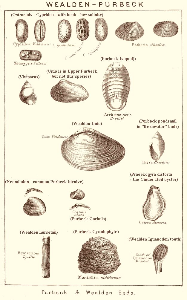
Various fossils from the Cretaceous and Tertiary strata of the Isle of Wight (and other regions) are shown here. Note the lagoonal Purbeck Formation is underground and is not present in the cliff, but known from the Arreton Boreholes. The mainly fluvial Wealden consists of mottled marls, yellowish sandstone beds, some shales and thin limestones. It has some very interesting non-marine faunas, including remains of Unio-like bivalves, ostracods and gastropods (Viviparus) It is particularly notable for dinosaur remains and such creatures as Polacanthus, Brachiosaurus, Iguandodon and Hypsilophodon have left their bones in these strata. The main exposures are near Brook in the southwest and around Sandown in the southeast. The Lower Greensand is a notable fossiliferous formation in the Isle of Wight with remains of marine organisms such as lobsters and various molluscs, including the robust Mulletia mulleti, formerly known as Perna. The unit can be seen at Compton Bay, Atherfield area (where it is particularly well-developed) and at Sandown. The Gault Clay is fossiliferous in places, but because this "Blue Slipper" is often associated with landslides it is not usually cleanly exposed. The Upper Greensand forms prominant cliffs and is particularly fossiliferous. Some examples of Upper Greensand fossils are shown here. They are of marine origin. Chalk fossils are present at Compton Bay, Culver Cliff, the St. Catherine's Down area and at many other places.
Fossils of the Tertiary strata include the Eocene fossils of Alum Bay and Whitecliff Bay. The London Clay, the Bracklesham Group and the Barton Clay contain fossils (although Bracklesham fossils are rare at Alum Bay).
PALAEONTOLOGY:
Fossils of the Solent Group


A selection of just some of the many species of Solent Group (Upper Eocene to Oligocene) fossils are shown here. Most, but not all, of the common ones are included, together with a few rarer species. Some of the diagrams are very old, with a few names updated. The nomenclature on the figures should be treated with caution.
The molluscan fossils of the Solent Group are generally different from those of the marine Eocene strata beneath. They are most frequently found to be fairly small, white and thin-shelled and occur, often in abundance, in thin-bedded strata. They are preserved as aragonite, but usually without any preservation of shell colour. Most of them lived in lacustrine conditions or brackish, lagoonal water. Gastropords such as Galba ( Lymnaea ) or Viviparusare common in freshwater strata such as the Bembridge Limestone. Planorbis - type gastropods are also typical of freshwater strata, and charophyte algae may be present with them. Brackish water molluscs include Corbicula and various cerithid (ornamented and turreted) gastropods. There are some truely marine horizons, usually fairly thin and particularly recognised by the presence of oyster shells or "Barton Clay - type" gastropods such as Athleta.
The Solent Group is very well exposed on the Isle of Wight and this is the best place in the country to see fossils of Upper Eocene to Oligocene age. The Group includes the Headon Hill Formation, particular well seen at Headon Hill, near Alum Bay in the west of the Isle of Wight. It is also present at Colwell Bay, Totland Bay and elsewhere. There are freshwater lacustrine, brackish water and some marine fossils. The Bembridge Limestone Formation is present around the shores of much of the northern (Solent) coast of the island. It contains various freshwater pondsnails. The Bouldnor Formation contains freshwater to marine molluscs. It also contain fossil insects, not shown here. Remains of crocodile (rare) and turtle (fairly common) are present in the Solent Group.
Younger strata than the Solent Group are Pleistocene and Holocene. These Quaternary deposits contain remains of elephants (as at Freshwater Bay), bison (as at Newtown Estuary), hazelnuts (near Brook) and other fossils.
LOCATIONS:
Headon Hill and Totland Bay


LOCATION:
Freshwater Bay (Southwestern I.O.W.) - Introduction


The Upper Chalk is well exposed in Freshwater Bay. It dips steeply towards the north. There is little evidence of faulting. Brown Pleistocene deposits, in which mammoth teeth have been found, lie above the eroded surface of the Chalk. They are from the lower valley slopes of the old Western Yar, now truncated by coast erosion at Freshwater Bay.
LOCATION:
FRESHWATER BAY, Western Side
(beneath Fort Redoubt)


The western side of Freshwater Bay is easily reached by a very short walk from the car park. After the sea defences are passed, there is a cliff of south-dipping, Micraster Zones Chalk, with reddish-brown Quaternary
deposits cutting down toward the centre of the bay. The exposure is beneath a mid-Victorian fort, now a private residence. The place is Fort Redoubt. The name "Redoubt" refers, according to Wikipedia, to:
"a fort or fort system usually consisting of an enclosed defensive emplacement outside a larger fort, usually relying on earthworks, though others are constructed of stone or brick. It is meant to protect soldiers outside the main defensive line and can be a permanent structure or a hastily-constructed temporary fortification..."
This redoubt has a deep cutting on the landward side which descends through the thin edge of brown Quaternary deposits into the steeply-dipping Chalk.
LOCATION:
Freshwater Bay - Eastern Chalk Stacks


LOCATION:
Freshwater Bay - Quaternary Deposits


Pleistocene River Gravel at Freshwater Bay
Pleistocene river gravel, Valley Gravel, occurs at the Freshwater gap. Osborne White (1921), pp 166-167, commented on this:
"Much of the superficial material mapped as Valley Gravel on the sides of Freshwater Gap is of a different character from any of the deposits in that class described in the preceding pages. Valley gravel, consisting of partly-worn flints with chert and ironstone, in places cemented by iron oxide, is seen low down on the sides of the gap; the bulk of it is probably derived from older gravels in the country that once existed to the south; but the superficial deposit most in evidence in the cliff section is a banded chalky wash, or rubble drift which overlies parts of the gravel and was formed under different conditions."
Pleistocene Head at Freshwater Bay
Here are some comments of Osborne White (1921), p. 167, on the Head deposits at Freshwater Bay.
"On the eastern side of Freshwater Bay, a sheet of the chalky gravel and loam, mentioned in connection with the Valley Gravel, occurs on the top of the cliff, and a little outlier of it, which has long seemed in imminent danger of destruction, clings with remarkable tenacityto the apex of the Stag Rock. The deposit thickens as it descends into the valley at Freshwater Gate, and is well seen in the cliff near the protective fascines. A tooth of Elephas primigenius has been obtained from it on both sides of the valley, and Godwin Austen, by whom these finds were recorded, observed numerous shells of the land molluscs, "Pupa muscorum" and "Succinea oblonga" in the wash on the eastern slope. The deposit belongs to the widely-represented class of late Pleistocene "heads" of which the well-known Elephant Bed, overlying the Brighton raised beach at Kemp Town, is a type."
More on Freshwater Quaternary - Forbes
(The following is from p.2 et seq. of Forbes (1856), edited by Godwin-Austen.)
" II. 1. The Gravel of Freshwater Gate, with Elephant's Remains
"These gravels are well exhibited in the cliff sections of Freshwater Bay, and are interesting and instructive, as they show most clearly that the superficial accumulations such as those which cover so large a portion of the surface of the Isle of Wight, and which to the casual observer would hardly seem capable of subdivision, are yet separable into groups referabletro very distinct periods of past time.
Freshwater Gate is situated in the most western of the several transverse depressions which the range of the highly inclined chalk strata presents in its course through the Isle of Wight; and the only difference is to be remarked upon is this, - that the Freshwater depression is the deepest of these, extending down to the present sea level. The highest portion of the chalk range, as Beacon Down on the West and Afton Down on the east, present only a thin coating of angular flints, the residue of that portion of chalk which has been dissolved away. Thes downs are good illustrations of the rate of waste over calcareous surfaces from the action of rain-water alone. Detritus and gravel beds occupy the lower slopes, as shown in woodcuts Nos. II and III.
On the west side of the valley (Vignette III [- shown as an illustration above, re stacks]) the superficial beds reach a considerable elevation, descending thence continuously to sea level. Starting from this lower line, it will be seen that the gravel beds which rest immediately on and against the chalk are composed of coarse sub-angular and water-worn flints, with chert and ironstone from the lower cretaceous beds; the whole coloured and somewhat cemented by iron.
[Sequence on the West Side of Freshwater Bay.
1. West Side; Older Gravel, Red: Basal, Horizontal, Dark Gravel Beds, without Chalk Pebbles - channel deposits up to about 4m thick]
The lower gravel beds conform to the irregular surface of the chalk, but higher up the mass has a marked horizontal arrangement with occasional bands of coarse sand. These lines of successive accumulation, when traced out toward the valley, end abruptly along a line which slopes at an angle of 30 degrees, and which is distinctly marked through a vertical height of 14 feet (4.26m).
[2. West Side; The Diagonal Bed on an Erosional Slope]
The bed which follows next on this slope is rather more than an a foot (0.3m) in thickness, and agrees so completely with the gravels against which it rests, that it could not be distinguished from it but for the arrangement of the materials which is in accordance with the slope.
[3. West Side; Newer Gravel: Younger Horizontal, Cross-Bedded, Sandy Gravel, Valley Fill with Chalk Pebbles (lighter-coloured gravel)]
The diagonal bed here described separates the dark gravel from another horizontal series, which is very distinguishable both by colour and composition. The materials are generally finer, and the thickness and number of sand beds greater. These last, more particularly in the lower portion, show the cross bedding which is produced by drifting currents having opposite sets at different times. There occur throughout this newer gravel a considerable admixture of small rounded detritus of white chalk, which is wholly wanting in the older gravel.
[4. West Side; Late Transgressive Phase - Coarser Gravel]
After the newer series had been raised to the level of the older one, it appears to have spread out [transgressed] over it. This portion, which is not thick, resembles the older gravel in coarseness and the newer in colour, and consists, in fact, of the re-arranged surface of the older gravel beds.
[5. West Side; Brickearth with angular flint - near the top]
These accumulation are overlain by the brick-earth deposit, which contains here, as elsewhere, the usual disseminated fragments of angular flint.
[6. West Side; Top Chalk Talus
The newest bed to be noticed here is that which occurs in superposition on the foregoing, along a line at the base of the chalk hills. It consists largely of chalk rubble and detritus with angular flints. It has a marked banded arrangement, conforming to the slopes above it, all of which is talus. It must not be confounded with the underlying gravel beds, and considered portion of them as has sometimes been done elsewhere.
[end of West Side Quaternary Sequence]
.
[Freshwater Bay Quaternary - East Side]
The Newer Gravel series has been cut out along the central line of the valley, just as the older ones had been in some earlier time. The superficial deposits on the east side of the valley (Woodcut II) do not correspond exactly with those on the west. The removal of the Older or Red-Gravel series has taken place to a much greater extent and the bulk of the mass consists of the Newer Gravel and brick-earth.
LOCATION:
Freshwater Bay
Shear Planes and Fracture of the Chalk

Freshwater Bay has unusual Chalk cliffs in which the bedding planes are not clearly conspicuous in much of the Bay. They are best seen in the southern part of the eastern cliffs, as in the photograph above. Even there, in the Micraster coranguinum Chalk (Seaford Chalk Formation), were it not for the flint (enhanced in the photograph) the bedding would be much less conspicuous than the shear planes or joints. There are numerous fractures, especially ones dipping at a low angle to the north, but displacement on them is minute or zero.

At some other parts of the bay it is difficult to see the bedding at all. The sequence of Chalk from the Marsupites testudinarius Zone up to the Actinocamax quadratus Zone (Newhaven Chalk Formation) consists of white chalk that has few flint bands and therefore does not show the bedding very clearly. The junction with the Newer Gravel (rather sandy) is clearly seen. There is not much Brickearth just here.
Freshwater Bay is an interesting locality because the overlying land surface has not been appreciably eroded down here since the late Pleistocene glacial phase. Solifluction has not removed the uppermost exposed Chalk. In addition the cliff erosion provides good sections through the fractured Chalk.
(Problem: In the stacks (see photographs above) the shear planes or fractures clearly dip south at low angles, whereas here in the coranguinum Zone in the eastern cliffs the dominant dip of fracture planes is northward at low angles. More study is needed!)
LOCATION:
Chalk Road Cutting, Compton Down and Afton Down (between Freshwater Bay and Compton Bay)
There is a road cutting in the Chalk on the A3055 (Military Road) above Freshwater Cliff. The cutting is into Afton Down and Compton Down between Freshwater Bay and Compton Bay (near Brook). It is on the main route southwestward from Freshwater Bay. The road, just here, has been threatened by cliff falls of chalk. The exposure is not particularly impressive and gradually becoming weathered and overgrown. Note that there is risk of accident due to passing vehicles. However, the cutting may be of interest to specialists working on the Chalk.


The cutting in the Lewes Nodular Chalk Formation exposes chalk of the St. Margaret's Member (Sternotaxis planus and Micraster cortestudinarium, and adjacent. This is approximately Turonian to Coniacian; in old terminology this would be the top part of the Middle Chalk to the lower part of the Upper Chalk. See: Insole et al. (1998) for more details. They mentioned (see p.100) that at the eastern (Brook) end of the cutting the St. Margaret's Member is visible (or was visible) just above the scree. 3.5 m above the top of the hardground lies the "Black Band", a thin marl correlatable with the Southerham Marl in Sussex, and that 4.5m higher there is a bed rich in the bryozoan Bicavea.
Go to the Compton Bay, Hanover Point and Brighstone Bay Webpage for more information. Click the link below:
Brighstone-Bay, Wealden, southwestern Isle of Wight
.

Brook Chine is in a low and gentle valley descending from the village of Brook. Thus, although coastal erosion is very rapid here, the valley is not left as hanging, high above the shore. It is likely to be still accessible when all the other chines on this southwest coast have been eroded back and rendered too steep for easy access to the beach.
LOCATION:
CHALE BAY AND ATHERFIELD POINT
(southern Isle of Wight)
.

.

.

.

.

.
LOCATION:
ATHERFIELD AREA, SOUTHWEST ISLE OF WIGHT - SHALE GAS, FRACKING PROSPECTS
Introduction
.


.
The great thickness of the Cretaceous Lower Greensand in the Atherfield Point area is a useful surface indication of the Portland-Wight Basin, or English Channel Inversion. The Lower Greensand (excluding the Carstone) was the last unit to be deposited before the deep basin in the English Channel and southern Isle of Wight, before the basin downwarping ceased, with the Late Cimmerian Unconformity. It was subsequently uplifted into the anticline of the southern Isle of Wight. This is why it is termed an inversion structure. There was a reversal of the direction of movement, particularly in the Tertiary.
Thus the southern Isle of Wight is situated over the eastern end of the English Channel Inversion which, with its great sediment thickness, generated oil from the Jurassic shales. The Portland-Wight Basin is well-known as the source area of the great Wytch Farm oilfield, the largest known onshore oil field in northwest Europe. So Atherfield Point or Chale Bay might possibly be of potential hydraulic fracturing ("fracking") interest. The Arreton Borehole has already proven that thermal maturity is at or near the critical level. However, Durlston Head, Swanage, Dorset might be closer to the appropriately mature Liassic Shales. Examine the example cross section above, which is based on a section quite close to the Dorset coast but very distant from the Isle of Wight.
Whether this ever happens depends on successful exploitation at Balcombe, Fernhurst or Wisborough Green. If those wells fail to be economically successful then the Isle of Wight is rather unlikely to be used. If, however, fracking works successfully there in the Weald, then it could probably work successfully from drilling derricks a short distance back the Atherfield cliffs. The wells would probably be deviated or horizontally extended out to the west. The strata on the southwest Island are very similar and are very similarly thermally mature (in the catagenic zone). The shales of interest are also beneath the 600m. depth safety zone. There is a shortage of forests (for concealment) reasonable close to the Military Road (probably needed for vehicle transport). There are several small woods in the area (examine the Ordnance Survey map). None are large but more could be planted, as happened at Wytch Farm Oilfield in Dorset. There is no large freshwater supply in the area for water injection, but seawater could easily be pumped up one of the chines (in a buried pipeline) in large quantities. Wytch Farm (completely hidden in planted forests) has for many years injected vast quantities of seawater from Poole Harbour, and there has been discussion of greater amounts at even higher pressure. It is possible that exploration from the southwest Isle of Wight would follow successful production from the same strata and same maturity as in the Weald Basin. However, this is not the only possibility and already there is borehole exploration planned for gas at Durlston Head, Swanage (by Infrastrata from California Quarry). Long Extended Reach Borehole could theoretically reach the deep areas of the offshore Portland-Wight basin from the Dorset coast. The good, thick cover of Cretaceous strata near Atherfield is a safety advantage of drilling from the Isle of Wight.
IOW-6-7 WHALE CHINE
.

.

.

.

.

.

.

.

.

.

.

.

.

.

.

.

.
Whale Chine is Chale Bay, near Chale in the southwestern Isle of Wight. It is about one and half kilometres southwest of Atherfield Point and formerly was a key place of access to this part of the coast The chine is narrow ravine eroded by a stream and cut into Lower Greensand (the Ferruginous Sands in the broad sense). The cliff top is at a height of about 43m. The name is supposed to come from the Wavell family rather than the sea mammal (Wikipedia). There were steep wooden steps but periodically these are damaged by coastal erosion. The council is not prepared to make a permanent access structure, so Whale Chine access from the cliff top is quite often closed. The steps down were closed when some photographs, shown here, were taken in December 2014.
Safety matters are in general dealt with elsewhere. There are a few points to note, specifically, with regard to the Whale Chine area. At the foot of the cliff in this region there can be risk of being cut off by a rising tide, at least in storm conditions. There is risk from blocks falling from the cliffs. There is considerable risk on the cliff slopes or undercliff of being stuck in soft mud. On the cliff top, there can be a hazard of an overhanging cliff edge, so keep back. During storm conditions with a strong wind blowing from the sea, there can be a seaward backdraft on the grass top near the cliff edge.
The strata here are all part of the Lower Greensand. The cliffs are very brown because the main unit is the Ferruginous Sands Formation. These are 500 feet or 152m. to 510 feet or 155m. thick. These deposits are brown and sandy and in best condition very rich in oxidised berthierine ooids. In other words the deposit is a sandy oolitic iron ore, like the Middle Jurassic, Northampton Sand Ironstone Formation. The berthierine ooids underground are probably greenish and the brown appearance is the result of recent surface oxidation. It is probably the result of intense weathering on the land in moist warm conditions and the transport of iron into the nearby sea. The northern part of the Isle of Wight was uplifted in the Cretaceous. There is a marked unconformity, the Late Cimmerian Unconformity, which is developed in the northern Isle of Wight. Details of this will be explained in other sections of this account.
[Note. If you are unable to access the coast at Whale Chine, the Ferruginous Sands Formation is quite accessible at Compton Bay, and can even be seen in the road cutting of the Military Road as it ascends towards the Chalk Down. The details are different}
IOW-6-7a WHALE CHINE continued
- The Ferruginous Sands Formation. - Subdivisions in the Old Memoirs.
.
The following text is to give historic information regarding the geology of Whale Chine, and is selected for the that purpose. Some modern translation is also give.
The old subdivisions of the Ferruginous Sands Formation have been given by Bristow (1889, a very old Isle of Wight Memoir) and by White (H.J. Osborne White), 1921 Memoir and other editions of the British Geological Survey Memoir. A summary of the old accounts in relation to Whale Chine, and from White (1921, p. 26), follows here.
"The Lower Crioceras Group, VI (16ft - 4.9m) contains several bands of Crioceras? bowerbanki (d'Orb.) in sand.
[Correction note: Actually this ammonite is - Tropaeum bowerbanki (J. de C. Sowerby, 1837) and is the index fossil for the highest zone of the Lower Aptian. It is a heteromorph and a giant uncoiled ammonite of up to 40cm or more in diameter. Regard further old statements here, and elsewhere in the text, to "Crioceras" as referring in fact to Tropaeum.]
The lowest band (said to have yielded the best specimens to the early collectors) declines to the beach west [presumably NW] of Whale Chine; the highest crosses the bottom [the bottom in the past] of that chine.
The Walpen (and Ladder) Sands and Clays VII (57 feet - 17.4m.) comprise:
Clayey, passing down into sandy, beds; with Panopaea mandibula, Pinna, Dentalium etc. .. 33 feet or 10m.
Dark green clay with nodules containing Exogyra sinuata and
Douvilleiceras martini (d'Orb.). .. 24 feet or 7.3 m.
The clayey beds of this group [the Walpen and Ladder Sands and Clays, VII], throwing out water, form the undercliff upon which Ladder Chine opens. They come to the beach about 200 yards (200m. approx) east [i.e. southeast] of that Chine [Ladder Chine is southeast of Whale Chine and does not descend to the beach, going about halfway down the cliff].
[It is important to note that the Walpen and Ladder Sands and Clay are apparently the major source of springs and landsliding and the development of an undercliff in the vicinity of Whale Chine; see the photographs above of the cliffs just southwest of the Chine.]
The Upper Crioceras Group VIII (46 feet or 14m.) contains four or more courses of Crioceras ? bowerbanki [i.e. Tropaeum bowerbanki] with Douvilleiceras martini, Gervillia forbesiana d'Orb. Trigonia vectiana Lyc. Terebratula, etc. It is upper limit falls to the beach east of Walpen Chine."
[the text continues with description of the Walpen and Ladder Sand, IX etc., but is not given here.]
LOCATION:
BLACKGANG CHINE
(southern Isle of Wight)

.

.

.


Blackgang Chine is a famous locality on the Isle of Wight and once used to be a major chine or valley giving access by a path to the beach. It was a place for fisherman, and also for smugglers to land their goods and get them up the cliffs. A sad event here was the wrecking of the East Indiaman, Clarendon during a storm in October, 1836. An old etching, modified and shown above reveals something of the coastal geomorphology at the time.

The original chine was natural, undeveloped and scenically very attractive. Landsliding and cliff retreat in recent years has caused loss of the original chine. The area on the cliff top has been changed into Blackgang Chine Theme Park, a good place for children to enjoy.
Blackgang area is one of the most notable places for landslides on the Isle of Wight. The Upper Cretaceous Gault Clay underlies a well-developed sequence of porous and permeable Upper Greensand, with Chalk above. The Sandrock of the Lower Greensand forms the lower part of the cliff with some Ferruginous Sands at the base. Most the strata low in the cliff, though are covered by landslide debris that has slipped down from above. Because of the landslides the area is quite complex to explore because original roads and paths have been cut or destroyed.
A major landslide in January 1994 has been well-described by Mark Davies (1994), who was at that time an Environmental Science student at Southampton University. Shown above are the remains of Gore Cliff Cottage, adversely affected by the landslide of 1994. For another photograph of this building (at a slightly earlier stage) see the document Understanding Demolition Costs for Properties Affected by Coastal Erosion, March 2010 (Final Report by Scott Wilson).
See particularly the detailed map of the landslides of Blackgang and Gore Cliff provided by Bromhead et al. (1991). A modified version of this map can be seen as Fig. 19 on page 74 of Insole et al., 1998 (The Isle of Wight, GA Guide).
LOCATION:
Blackgang Chine - Landslip of 6th March 1978
.

.
[The following is from a report in the Southern Evening Echo, Monday, March 6th 1978, with photographs.]
"Island Landslip"
"The Beauty Spot that Crumbled"
By Echo Staff Reporter, Peter Hall.
The landslip scene near Blackgang on the Island's southern coast resembled an earthquake disaster area as parts of houses, a road, trees and a car slipped down the cliff towards the beach 200ft below.
Two cottages were wrecked, a big family house was left with rooms open to a huge drop, and a holiday camp for naturists was left damaged, marooned and almost certainly doomed. The slide happened almost exactly 50 years after the massive landslip of 1920 which took away the Blackgang-Ventnor road that once ran a short distance away.
The slip gave an early warning and residents were able to get to safety before the first big drop came. Risking life and limb as the earth trembled beneath them, they went back repeatedly to rescue precious possessions. Helped by friends, neighbours and a team of volunteers, some from the South Wight Council, they carried furniture, clothing and household goods across three-quarters of a mile of rugged ground to the nearest road.
The slip is at the section of the coast between the Blackgang side of Cliff Cottage to Southview naturist camp, an area already partly "subdivided" by earlier falls. Heavy snow and rain in recent weeks is thought to have undermined the unstable blue slipper clay [See notes elsewhere on the well-known "Blue Slipper" clay of the Isle of Wight, i.e. the Gault Clay]. Heavy snow and and rain in recent weeks is thought to have undermined the already unstable blue slipper clay and sand in the cliff.
The area here has been so notorious for landslips that none of the properties was insurable for the risk. Owner of Cliff Cottage, Mr. Rex Watson, a Wootton Bridge garage owner, who had been living in a caravan in his garden because of the instability, described the scene as the first slip came. "It was a bit like an earthquake. I moved out as soon as the first tremor started and got to the safety of the Blackgang road. His cottage collapsed.
Further along, Sandrock Spring, home of Mr. Richard Young (73), his wife Mrs. Dorothy Young and their son Christopher for 30 years was devastated. Parts had already gone over the cliff and the rest stands there on borrowed time.
Across the road a cottage owned by the Youngs for summer letting collapsed, leaving �2,000 worth of furniture buried beneath rubble. Mr Young estimates his loss at $50,000 but an even bigger loss in cash terms may be suffered by Mr. Bert Wrate, proprietor of Southview holiday centre for naturists for the last ten years. His estate is marooned and could slip away at any time. A dozen of the 18 chalets have already been wrecked. Mr Wrate said: "If it happened abroad there would be an aid programme, but I don't suppose we will get anything. Local councillor Mr. Malcolm Dyer organised a work gang and helped the salvage. He provided storage for furniture at his nearby farm and said he would do all that he could for those who made homeless.
A geologist, Mr. John Perkins [is this John W. Perkins author of the well-known geology guide books?], who visited the scene explained the cause. "Snowfall on the plateau above was extremely heavy, and when it melted water ran through to the clay and sand beneath. The weight of the water had undermined the base of the cliff. He said there could be further movement of the cliff before it settled and some sections at the top of the plateau could also fall.
[There is another article in the "Echo" entitled "More Landslips Fear". It mentions that "By last night, a three quarter of a mile long, 300 yard wide strip of cliff-top beauty spot at Blackgang Chine had disappeared. "Mr Rex Watson told me: "I could see the whole cliff moving, hear all the tree cracking and there were terrific blue flashes as the electricity cables parted.". A car ended up half way to the beach and was lost. In a previous landslip a car had been rescued by Royal Navy helicopter.]
The Cretaceous, Gault Clay of the Isle of Wight is know locally as the "Blue Slipper" for obvious reasons. It is from time to time the cause of IOW landslides, and may well be responsible for one at St. Lawrence recently, 2013-4. It is an impervious and impermeable clay underlying the permeable and pervious Upper Greensand and the contains the expandible and "slippery" clay mineral - smectite. It will, of course, cause more landslides from time to time in the southern part of the Isle of Wight.
A BGS technical report on the Gault Clay contain useful data, a very little of which is summarised briefly here. See [available online as a pdf file] - British Geological Survey: Engineering Geology of British Rocks and Soils - Gault Clay. Engineering Geology and Geophysics Group. Technical Report: WN/94/31. Here are some brief extracts:
"Gault Clay contains both clay and non-clay minerals.
The major non-clay minerals are quartz and calcite.
Quartz usually makes up about 20% or more of the Gault
and its distribution is fairly uniform. Calcite is present as
fossil debris and as a cementing agent. The Gault is more
calcareous in the north east than the south and west.
The major clay minerals present are kaolinite, illite and
smectite. Two main clay mineral assemblages have been
identified 'Kaolinite-illite' and 'Smectite-illite' . Higher
concentrations of smectite have been found in fissures and
in the zones around shear surfaces in landslips....
Where Gault clay is part of a major, inland escarpment or coastal cliff, large, deep seated, landslide complexes have developed as at ... Ventnor on the Isle of Wight. The Gault .. contains significant amounts of expansive clays .. and is in the "Very High Expansive Potential Category". It may also contain significant quantities of sulphate or sulphuric acid."]
For more detailed information read the online report. .
LOCATION:
Gore Cliff and Sandrock Road
(Southeast of Blackgang Chine)


Originally, the Victorian coast road, the Military Road (now the A3055) extended the western Undercliff slopes to Blackgang Chine (it still extends along the Undercliff from Ventor in the east to Niton in the west, and it has not yet been broken through). In part of Knowles Farm (now National Trust), at the southern end of Gore Cliff (Windy Corner), it was broken through by a major rock fall and landslide in September 1928. In spite of the name "Sandrock Road" the road is largely on Gault rather than Lower Greensand Sandrock.
The photographs above show the same location at Windy Corner and Sandrock Road (part of Knowles Farm) and Gore Cliff in 1928, 1992 and 2011. Rock debris from the upper part of the landslide can be seen in front of what is now the car park, but to some extent it seems to have subsided. This presumably the result of continued movement on the the underlying landslide.
LOCATION:
Rocken End (Southwestern End of the Isle of Wight)


Rocken End is a promontory almost at the southern end of the Isle of Wight. It is less than a kilometre from St. Catherine's Lighthouse at St. Catherine's Point, the southernmost part of the island. Rocken End is composed of fallen debris from landslides. Beneath the debris Gault Clay is above Sandrock (Lower Greensand).
.
.
Undercliff-Introduction">
THE UNDERCLIFF LANDSLIDE AREA
Introduction
.
A simple introduction is given in the 1898 edition (by Reid and Strahan) of the Isle of Wight Geological Survey Memoir. 2nd edition. [the extract is reproduced in the 1921 Edition by Osborne White]. Here is an introduction description from the old publication:
"The beautiful and romantic scenery of the Undercliff or 'Back' of the Island has been mainly caused by the sliding of the Chalk and Upper Greensand over the unctuous surface of the Gault clay, the tendency to slide being principally due to a rather pronounced seaward dip, and to the outburst of springs at the junction of the porous Upper Greensand and impervious Gault.
Through the greater part of the Undercliff the slipped materials assumed a position of rest before the Historic period [i.e. there is no historic record of the landslide and it presumably originated as a result of cliff erosion during the later stages of the Flandrian Transgression, the flooding of the English Channel]. It seems likely that in the belt of ground occupied by the slip, the southerly dip was steeper than it is in the existing cliff, and that the strata now forming this cliff will never be in a position to slide so readily as those portions have already gone. Still, as the sea, in the course of centuries removes the fallen debris which forms the coast the movements will doubtless be renewned from time to time. Indeed at Blackgang and Bonchurch, the west and east ends respectively of the Undercliff, there have been great slips within the [last 120 years]."
At the western end of the Undercliff, below Gore Cliff, a great founder occurred in 1799, and the movement has been renewned at intervals ever since. A description of the East End landslip which took place in Bonchurch and Luccomb in 1810, will be found in Sir Henry Englefield's "Isle of Wight" [p. 131].
The most striking feature in the central part of the Undercliff is the succession of short escarpments produced by the fall of slices of Upper Greensand cliff. These portions range in size from mere blocks up to slices of half a mile in length. They have broken off along the vertical joints by which the sandstone is traversed, and as their bases slid forward over the Gault, have acquired a steep landward (northerly) dip. The process has been repeated several times, thus producing at different levels in the Undercliff a series of Upper Greensand escarpments, separated by deep hollows, which have been not uncommonly occupied by natural lakes. The distance to which they have descended varies indefinately. Above Bonchurch a very long but narrow slice has moved a few feet only, and still forms the principal face of the cliff. But many others, with a portion of the Chalk above them, have descended to the beach some 300 feet (91m.) below, and from a quarter to a half mile distant.
Such wholesale slipping is, generally speaking, confined to the coast, but some large masses of Greensand have slid down on all sides of St. Catherine's Down, and from the shoulder which separates Shanklin and Luccombe.
In some places the clay has flowed down in the form of mud-rivers [mud-slides], keeping usually to the lines of hollows in its descent, but overspreading also many of the higher parts of the Carstone [Lower Greensand] feature. The course and limits of these mud-rivers or gutters may be distinguished, for many years after they have ceased to move, by the large sods of turf which have been torn off and heaped in a little irregular bank along their edges, and by the lines which still serve to indicate where the mass of moving clay was traversed by long curving cracks, convex in the direction of movement. These mud-rivers [mudslides] extend sometimes to distance of a quarter of a mile or more beyond the base of the Gault.
At Winstone, a fine example of a mud-slide is crossed by the railway cutting, now grassed over. Another a little to the east has travelled down a hollow in the hillside and is now [1889] being dug for bricks."
LOCATION - VENTNOR
Ventnor Area (Eastern Part of the Undercliff)

.

.

.

.

.

.

.

.

.
Ventnor is a remarkable place. It is a largely Victorian, holiday town constructed almost entirely on a landslide that was originally as wild and unstable as the Lyme Regis to Axmouth Undercliff (an undeveloped area). Climatic factors were largely responsible for the development of the town; in such a southerly coastal area with south-facing slopes, there is a mild maritime climate.
.

.
Rather closer to Ventnor Bay, about half a kilometre east of it, is "Tetrapod Bay" (not an official name), a small embayment with concrete sea walls and a large number of the peculiar structures known as tetrapods. These are concrete, four-armed objects meant to slow wave action. Apparently they are used on a huge scale in some countries, and can prevent access to sea. They look very conspicuous and cannot be climbed over, even in an emergency. Although rock armour consists of rocks which are foreign to the site, they do have a fairly natural look, especially if they are of limestone (rather than larvikite). Rock armour is always conspicuous but it can fit in with the scenery to some extent.
.

.

.
At Wheelers Bay on the ENE side of Ventnor, there is a very resistant sea wall and much rock armour. This is the result of sea defence work in the early 1990s, that cost 1.6 million pounds. It may hold back sea erosion but, of course, it may be only of minor relevance if major landslide activity takes place again on this part of the landslipped "Undercliff". Of course, this is not necessarily likely to happen soon, but the whole southern coast here is a landslide area and liable to move from time to time in the long-term (in 2014 there have been problems further west and the main A3055 road has been closed in part).
.

.
LOCATION - BONCHURCH
Northeast of Ventnor
.

.

.

.

.

.

.
At Bonchurch, as at Ventnor, there are cliffs of landward-rotated Chalk, within the Undercliff Landslide. These result from movement on an underground, curved slip plane, when the landslide initially developed. This is a small part of the Bonchurch Landslips, probably active over the last two centuries.
.
.
IOW-5-3. LOCATION - UNDERCLIFF, SOUTHERN ISLE OF WIGHT:
St. Lawrence Landslide Area (Central Part)
.
There had been been major storms and very heavy rainfall in early 2014. Meteorological Office statistics for Winter 2014 show that England and Wales has had its wettest winter in almost 250 years. From the 1st December 2013 to 19th February 2014, there was a rainfall of 486.8 mm.; for records dating to 1910 this was the wettest winter. There was much flooding in England, and on the coast there were many cliff falls and landslides. The Lyme Regis to Axmouth Landslide area was affected with new movement taking place. There was local re-activation of slide planes and debris was falling over the cliffs. The southern part of the Isle of Wight was affected and the Undercliff Drive was cut by a small landslide or mudslide. This was reported in the press. An extract is given below, and further down are photographs of the slipped and fractured part of the road in December 2014.
.
For an early report of a landslide affecting the Undercliff Drive, St. Lawrence, go to the news article of the 18th February 2014:
Isle of Wight Landslip: Remaining Homes Evacuated.
"Residents remaining on a crumbling road on the Isle of Wight are to evacuate their properties as the land there is becoming increasingly unstable. Occupants of nine homes in Undercliff Drive, between Niton and St Lawrence, were advised to leave on Friday after a landslip caused the road to collapse. A handful initially refused to leave but those remaining are expected to leave in the next 24 hours. One evacuated bungalow has already suffered serious structural damage. Some residents had told the council they were reluctant to leave because their insurers said moving out would invalidate their insurance. Council deputy leader Steve Stubbings said: "We can't tell them they've got to leave but we have advised them to leave because we are concerned about continuing movement in the area. "I understand the rationale behind them staying for the time being and we are doing every we can to give them sound advice in terms of what their best movement would be from now until we can get this situation sorted out." ........... [continues]
They [the residents] appear to be very stoic. It is an area which is recognised as being particularly unstable and has been for a number of years. Historically it has seen slides and with this unprecedented rainfall, I don't think it has helped the situation." ..... [continues]
The road, on the southern tip of the island, began to show signs of movement on Wednesday but Friday's storm accelerated the landslip and residents were told to move out for their own safety. Isle of Wight Council said the decision was made to evacuate homes because of safety concerns, a lack of access and uncertainty about utility supplies.
.

.

.

.

.

.

.

.

.

.
As shown above, in 2014, there were some problems with a small landslide breaking through the coast road on the southern Isle of Wight Undercliff at St. Lawrence. The whole Undercliff has at some time in the past, and as is well-known, collapsed from the upland area of Chalk Downs to the north. It is very similar to the long stretch of the Lyme Regis - Axmouth Undercliffs. See the lower part of the webpage (scan down):
Lyme Regis Westward.
Both Undercliffs have permeable Cretaceous strata, including Upper Greensand and Chalk, above clays. In the Undercliff area west of Lyme Regis the main clay responsible for movement is the Liassic clay. In the Undercliff area of the Isle of Wight the main clay involved is the Gault Clay (in the past known as the "Blue Slipper"). The Lyme Regis - Axmouth Undercliff had a few houses on it, but with continuing slipping they have been destroyed. In contrast the Isle of Wight Undercliff has been much developed in places, even with built-up areas of St. Lawrence and Ventnor within the landslide belt. The Isle of Wight Undercliff does not seem to have moved as much in the 250 years as has the Lyme Regis - Axmouth Undercliff. This western landslide locality has no road through it but it has a footpath which moves with minor landslides and it is closed from time to time.
The Isle of Wight Undercliff is more dormant, but it shows some movement from time to time, here and there, but not recently on a large scale. The main road, the A3055, has been necessariy diverted at Niton, because it once went round seaward of Gore Cliff (near Blackgang Chine) but was destroyed by landslides there. What is happening now at St. Lawrence has already led to a road diversion, and it remains to be seen whether this is permanent.
The present small landslide seems at present only to be on the scale of the mudslides (although it seems not to be a simple mudslide) in the cliffs of Barton-on-Sea. It is, of course, not known whether it will remain just very limited or whether it will extend seaward. It is quite likely to extend seaward. What is obvious is that it will extend laterally along the road to the east. This is shown by extensive cracks in the road, roughly parallel with the road direction, and these cracks show small-scale subsidence on the seaward side. This is very similar to the start of failure at Sea Road Gap, Barton-on-Sea. This was a narrow road giving Council vehicle access to the Barton undercliff (for sea defence work). The cracking of the tarmac was the first sign, (resembling that at St. Lawrence east of the present collapse) and was it seen in 2009, when you could still walk over it. By 2014 it had become a major mudslide extending down to the beach. There was no further question of vehicle access here and it is now no longer possible to even walk down. The path or old road leads to a cliff edge with soft mud at the base.
Obviously, wet weather increases the chances of movement. The mudslides at Barton usually develop over several years, with increased movements in the Winters and Springs, especially after very wet weather. Eventually they become relatively stable and in due course (some years later), another one commences elsewhere.
The situation at St. Lawrence is very different in terms of the age of the geological stratal units. However, with nearly horizontal strata (actually a small dip) of clays and weak sandstones the Barton cliffs are not so different, on a much smaller scale, from the collapsed coastline of the southern Isle of Wight. However, the true analogue elsewhere is the
Lyme Regis to Axmouth Undercliff, famous for its landslides, and still moving in places this year (2014).
.
Further Comments on the St. Lawrence Landslide
As mentioned above, the visible (or at least behind the screens!) landslide is small with vertical displacement of about 5 to 10 metres. However, the shear plane or slip-plane is likely to be curved, as normal, and to run beneath the surface southward from the main road. Large boulder which seem to have been excavated from the site appear to be of the Upper Greensand, as would expected here. Of course, there were unlikely to have been in situ because of the original large-scale movement of the landslide. The relevance is this. If the Upper Greensand (especially the lower part with concretions) is beneath the road here, then a short distance further down is the Gault Clay, the famous "Blue Slipper" of the Isle of Wight. In other words if these preliminary view are correct then the curved slip plane would probably go through the Gault with a seaward inclination. Theoretically for every ten metres the ground goes down at the road then the land to the south should move ten metres horizontally in a seaward direction - but note this a simple generalisation and there may be exceptional circumstances which prevent this.
The landslide is not too different from Barton-on-Sea mudslides if it is based in the Gault clay (cf. Barton Sand above Barton Clay). Because the road is fissured a short distance further east, then the landslide will widen appreciably. This appears to be the situation, but the writer is not aware of proof of this, and this should only be regarded as preliminary guesswork. It is not known to the writer whether there are any open fissures up-slope of the road. Landslide specialists will know very much more about this and would able to confirm or correct the comments above!
.
Shanklin Chine to Luccombe Chine - Knock Cliff
.

.

.

.

.

.
(Details to be added)
.
LOCATION:
Luccombe Chine and Adjacent Cliffs

.

Shanklin is characterised by vertical cliffs of only moderate height of Lower Greensand. The main part, north of Shanklin Chine, is not subject to severe erosion. The sea wall is low and the promenade is relatively low in relation to sea-level (contrast with the sandstone cliffs and high sea wall of Dawlish, Devon). The beach does not show signs of rapid depletion. It consists of sand (some of it dark) mostly derived from the Lower Greensand and with subangular flint and chert pebbles.
The cliffs are not retreating because of the sea-wall and promenade and yet, as at adjacent Lake, are suprising vertical and lacking vegetation. They contrast greatly with the sandy cliffs of Bournemouth, at a sloping angle, and now almost completely overgrown.
.
LOCATION:
Lake - Between Sandown and Shanklin
Cliffs of Ferruginous Sands of the Lower Greensand

.

.

.

.
Lake was once a small village, that took its name from a small stream running through. "Lake" is an old name sometimes used for streams or watercourses in the region (e.g. Rope Lake Head, Kimmeridge, Dorset). The village is now much built up in a continous stretch of housing from Sandown to Shanklin. There are good cliff sections of the Ferruginous Sands Formation of the Lower Greensand in the cliffs at Lake.
LOCATION:
IOW-6-14 - SANDOWN - General
.

.

.

.
[text to be added]
.
LOCATION:
IOW-6-15 - SANDOWN - Dinosaur Museum
(Dinosaur Isle)
See the Dinosaur Isle Website.


For study of the dinosaurs of the Isle of Wight the key work is that of Martill and Naish (2001). This may be on sale at the Dinosaur Isle Museum. It is an excellent book, published by the Palaeontological Association.
.
LOCATION:
IOW-6-15 SANDOWN, NORTHERN AND YAVERLAND -
(i.e. towards Culver Cliff)
.
The following photographs are from the cliffs at Yaverland, the northern part of Sandown Bay. They include the area of the Dinosaur Museum and the cliffs of Wealden and Lower Greensand and higher strata up to the Chalk in Culver Cliff. [more detail will be added]
.

.

.

.

.
Sandown Bay and Culver Cliff provide excellent sections through the Cretaceous strata at the eastern side of the Isle of Wight. These are comparable, but different in detail to the sections at Brighstone Bay and Compton Bay at the western side of the island. The cliff exposures seen from the beach are north-east of the Dinosaur Museum.
.
LOCATION:
CULVER CLIFF OF CHALK
.

.

.

.

.

.

.
[Risks - Some photographs above are from the Chalk with flints at a stratigraphically higher level than can be seen in Culver. These are views of recesses in the cliff which can be seen from the cliff edge at the southeastern end of Culver Down. Do not approach the edge. In addition, the uppermost Chalk can be accessed quite easily at low tide in Whitecliff Bay. Beware of falling rocks. It is possible at a good low tide, with a calm sea, to scramble round from Culver Cliff northeastwards into Whitecliff Bay (and the author has done this) but it is not recommended because it involves some wading and is not a safe procedure.]

For more on Whitecliff Bay see the separate Whitecliff Bay webpage.
LOCATION:
Hamstead Cliff and Hamstead Ledge


The geology of Hamstead Ledge and its vicinity is described in the Geologists' Association Guide, No. 60, The Isle of Wight, by Insole, Daley and Gale (1998) . This guide is essential for reference. It shows possible places to park a car and footpaths to the cliff. It then contains good descriptions of the Bembridge Marls Member and the Hamstead Member of the Bouldnor Formation.

LOCATION:
Thorness Bay (Southwest of Cowes)

Thorness Bay is on the northwestern coast of the Isle of Wight, on the coast of the West Solent. There is a Thorness Bay Holiday Park on the coast near Great Thorness. The bay is cut into Bembridge Marls, which are easily eroded and there are no high cliffs, just coastal slopes. Exposures are present in ledges at low tide. As the photograph above shows, there is not much visible at high tide.
See
Insole et al. (1998), particularly the map (Fig. 32) on page 120.
White (1921) in the Geological Survey Memoir, and referring to an older edition (1889) quotes as follows:
"In Thorness Bay the Limestone [the Bembridge Limestone] rises again, showing the same three divisions. The bottom block forms Gurnard Ledge, and the thin upper block makes a minor ledge opposite Sticelett Farm [Sticelett Ledge]. From Gurnard Ledge the Limestone runs as a marked feature in the cliff as far as Gurnard Bridge... [continues]"
See publications on the Bembridge Limestone and Bembridge Marls by Daley and co-workers, such as:
Daley (1972) and also Daley, Edwards and Armenteros (2000).
See particularly Daley (1999) - Palaeogene Sections in the Isle of Wight: a revision of their description and significance in the light of research undertaken over recent decades.
On page 55 and 56 there are specific references to Thorness Bay. Some brief extracts follow:
"Thorness Bay and Gurnard.
From Gurnard (SZ 467 953) southwestward to beyond Burnt Wood (SZ 437 927), intemittent cliff and foreshore sections occur on both limbs of the shallow Thorness Bay Syncline. The main focus of interest in the section is on the Bembridge Limestone and the lower part of the overlying Bembridge Marls Member of the Bouldnor Formation. The main focus of interest in the section is on the Bembridge Limestone and the lower part of the Bembridge Marls Member of the Bouldnor Formation....
Thorness Bay and the section near Gurnard Ledge in particular, has interested geologists since the mid nineteenth century and various aspects of the geology have been described in the Memoirs of the Geological Survey (Bristow et al. 1889; White 1921). Much early interest was palaeontological, with considerable attention being focussed on the "Insect Limestone", from which a large collection of fossil plants and insects was made by Smith (1874). Subsequently, a detailed study of the plant macrofossils led to the description of the "Bembridge Flora" by Reid and Chandler, 1926)....
More recently, the sucession has been redescribed (Edwards, 1967; Daley, 1969, 1973) and various aspects of the palaeontology researched in some detail. Isopods from the Insect Limestone were described by Martini (1972) whilst a major account of the insect fauna was undertaken by Jarzembowski (1980). Machin (1971) found that the Insect Limestone was the richest microfloral horizon in the local Palaeogene succession, although work by Collinson (1978) has indicated that plant macrofossils from it are now less common than in Smith's time. The macroinvertebrate fauna from the Bembridge Marls Member as a whole was described by Daley (1972, 1973).
Other references to Thorness Bay include Daley (1972, 1974), Curry et al. (1972), Daley and Edwards (1974, 1990), Jarzembowski (1976), Daley and Insole (1984, pp. 30-31) and Daley (1989)."
Some further notes from Daley (1999):
In Thorness Bay, mudcracks in a red clay 7m. below the top of the Headon Hill Formation contain elements of a wetland fauna (Brasenia, Aldrovanda, Caricoidea)
On the southern side of Thorness Bay Syncline the lower limestone has a markedly brecciated top, while the base of the Bembridge Marls is conglomeratic (Daley and Edwards, 1990). .. This is attributed to upwarping of the Porchfield Anticline prior to the deposition of the overlying Bembridge Marls Member. [There is much further information and sections etc in pages 56 to 60. This work by Daley (1999) is a key publication regarding Thorness Bay and Gurnard Bay, and should be consulted.]
PETROLEUM GEOLOGY - ISLE OF WIGHT
The Arreton Borehole (old studies)
Several exploratory boreholes for oil have been drilled in the Isle of Wight. Before 1960 the exploration commenced at Arreton (Falcon and Kent, 1960). The structure was a closed, east-west elongate dome south of the Chalk Ridge. The strata at the surface is Lower Greensand and the borehole extended down to the Inferior Oolite at 5161 feet (1573 metres). This is not as deep as most modern petroleum boreholes in the region, and therefore did not test Bridport Sands or Sherwood Sandstone (the reservoirs at Wytch Farm).
The first exploratory wells in the Wessex region in 1936 in obvious anticlines at Portsdown and Poxwell were disappointing and proved dry. Unlike Iran, where the geologists had been exploring, there was no significant oil in these anticlines. None was found in other similar folds in the area. Already, in 1960, Falcon and Kent (1960), both very notable petroleum geologists, realised that most of the Tertiary structures investigated (Poxwell Pericline, Portsdown Anticline, Chaldon Anticline etc) had developed too late to act as traps for oil migrating towards the edge of the Wessex Basin. Without enormous quantity of seismic data that exists today they did not have a good knowledge of the Cretaceous structure at depth, and the English Channel Inversion theory so familiar now, was not well-understood at the time (although intra-Cretaceous tectonism had been recognised since well before the 1930s).
Of course, it well-known now that oil did migrate towards the margin of the English Channel (Wessex in part) Basin. The Wytch Farm Oilfield is proof of this. Similarly oil migrated towards the margins in the Weald Basin (or Inversion). The Middle Jurassic oilfields of West Sussex and East Hampshire are proof of this. Now it is known that the migration was Cretaceous in age and was into Cretaceous fault traps (the intra-Cretaceous or Late Cimmerian structure are largely extensional faults, unlike the compressional folds of the Tertiary). Thus, although the Arreton Borehole was not targeted at Cretaceous traps, it was planned in the 1950s to find oil that had migrated to the edge of the basin. The general theory was correct but the exact location was not. Oil had not accumulated in the Corallian (as seen in small quantities at Osmington Mills) or the Cornbrash (as at Kimmeridge), and nothing seems to have been found in Middle Jurassic limestones, the reservoirs of the West Sussex and East Hampshire fields. These Middle Jurassic limestones were found to be more muddy and less suitable as reservoirs than in Portsdown and Henfield (Weald Basin).
Of general geological interest, it was noted that the Wealden had a thickness of 2010 feet (612 metres) and thus was like the thick succession at Swanage, Dorset. Only the upper part of the Wealden is exposed in the Isle of Wight cliff sections. The Purbeck was found to be 343 feet (104 metres), only a little thinner than in the type section at Durlston Bay. Data for depth of formation tops will found in Falcon and Kent (1960), Table 1. There is not a detailed log in this report though.

Most of the recent exploratory wells of the 1980s and 90s etc seem to have been targeted at fault structures north of the main Purbeck-Isle of Wight Disturbance (i.e. north of the line of the re-activated Variscan faults). There are major unconfomities beneath the Albian, as shown in a sub-Albian map above. The structural similarity with the Wytch Farm area is obvious, and the hope of finding another highly-successful Wytch Farm Oilfield has clearly been a driving force. Most boreholes seems to have been concentrated in the western part of the island, and thus closer to Wytch Farm. Theories of migration from an area with mature source rocks southwest of the Isle of Wight is a factor. Surprisingly the wells have proved dry so far. The problem might be one of migration. Even in the area south or southeast of Wytch Farm there are problems about a migration fairway. Appropriate juxtaposition of permeable strata at the right time was essential.
Another possible complication might be the regional easterly tilt during Aptian-Albian times. This is seen in the coast from Dorset to Devon as the westerly overstep of the Albian. If migration coincided with this movement, then there may have been not just a tilt up towards the high north of the basin, but also a tilt up westwards. In simple terms there could have been migration in the Cretaceous towards the northwest, rather than just northward. Undoubtedly though there is no simple pattern and the details have to be established.
The state of the reservoirs or potential reservoirs is not considered in any detail here. The Isle of Wight is fairly close to the eastern margins of the Triassic Basin and thus Triassic reservoir facies may be different from Wytch Farm (i.e. more marginal in facies). The Bridport Sand facies is finer-grained and a less satisfactory potential reservoir at the Marchwood Borehole, compared to the Dorset area. The Middle Jurassic is "muddy" according to the records of the Arreton Borehole. There are only very general comments here though, without technical detail and without conclusions. Obviously those who have studied the Isle of Wight boreholes will have a much clearer knowledge not only of the reservoir aspect but also of the possible migration aspect.
PETROLEUM GEOLOGY - ISLE OF WIGHT:
Borehole Details:
Sandhills - 2 Borehole

A exploratory borehole Sandhills No. 2 has been sited at Sandhills near Porchfield, in the northern part of the Isle of Wight, not far from Newport (A Sandhills No.1 Borehole had been drilled before 2001). The licences here had exploration targets for Sandhills No. 2 in both the Middle Jurassic Great Oolite (a major reservoir rock in the western Weald area such as Horndean and Singleton) and in the Triassic Sherwood Sandstone formations (the major and lower reservoir of the Wytch Farm oilfield). Before drilling the estimated potential recoverable reserves at Sandhills-2 were believed to be 10-15 million barrels in the Great Oolite and 20-80 millions barrels in the Sherwood Sandstone. Before the drilling the structure was well-established from seismic and the formations which could be oil-bearing were expected to be present.
In 2005, Northern Petroleum began exploratory drilling for oil, with its Sandhills-2 borehole at Porchfield. However, there was no success in finding useful oil reserves, even though the prospect initially seemed very promising. Northern Petroleum ceased operations at Sandhills in October 2005.
Please go to Isle of Wight Bibliography .
I am particularly grateful to Southampton University for running of this website from the Southampton University Server. Alan Holiday is acknowledged with thanks for providing excellent aerial photographs taken by him of the Isle of Wight. My daughter Tonya Loades has kindly assisted wiht phogographs of the Isle of Wight and I am very grateful for those images. I am very grateful to the members of various field trips over the years to parts of the Isle of Wight who have cooperated with field discussion and photography. Student parties from Southampton University and oil company groups have been particularly helpful. I am very much obliged to Mark Davies, who as an Environmental Science student in 1994 wrote an excellent project on landsliding at Blackgang Chine. I thank Sarah Glaccum for arranging a photograph to be taken of the specimen of Tempskya which she discovered. David Gaunt kindly provided a good photograph of the stacks at Freshwater Bay. Acknowledgement is made to Wikipedia Commons for a photograph of part of the cliffs of Sandown, Isle of Wight. An excellent photograph of Atherfield Point comes from Nicholas Turland, via Flickr, and the use of this is much appreciated. I am particularly grateful to our daughter Tonya Loades who has driven me to various localities in the Isle of Wight; this is very much appreciated.
| Home and List of Webpages
|Isle of Wight Introduction
|Isle of Wight Bibliography
|Whitecliff Bay
Brighstone-Bay, Isle of Wight
|Solent Bibliography
Copyright
© 2015 Ian West, Catherine West, Tonya Loades and Joanna Bentley. All rights reserved. This is a private, academic website intended to be useful for research, reference and educational purposes. Images and text may not be copied for publication or for use on other websites without permission or for any commercial activity. A reasonable number of images and some text may be used for non-commercial, non-charged, non-online and non- published academic purposes, including field trip handouts, student projects, dissertations etc, providing the source is acknowledged. All images so used must contain the original caption, including the copyright statement. Some images are not those of the author and the copyright is that of the original photographer and these are not for any use without specific permission from the source photographer. This particularly applies to aerial photographs, but also to some sets of field photographs.
Disclaimer:
Geological fieldwork involves some level of risk, which can be reduced by knowledge, experience and appropriate safety precautions. Persons undertaking field work should assess the risk, as far as possible, in accordance with weather, conditions on the day and the type of persons involved. In providing field guides on the Internet no person is advised here to undertake geological field work in any way that might involve them in unreasonable risk from cliffs, ledges, rocks, sea or other causes. Not all places need be visited and the descriptions and photographs here can be used as an alternative to visiting. Individuals and leaders should take appropriate safety precautions, and in bad conditions be prepared to cancell part or all of the field trip if necessary. Permission should be sought for entry into private land and no damage should take place. Attention should be paid to weather warnings, local warnings and danger signs. No liability for death, injury, damage to, or loss of property in connection with a field trip is accepted by providing these websites of geological information. Discussion of geological and geomorphological features, coast erosion, coastal retreat, storm surges etc are given here for academic and educational purposes only. They are not intended for assessment of risk to property or to life. No liability is accepted if this website is used beyond its academic purposes in attempting to determine measures of risk to life or property.

Webpage - written and produced by:
.
Written and produced by:
Ian West, M.Sc. Ph.D. F.G.S.
Romsey, Hampshire
Ian West, M.Sc. Ph.D. F.G.S.
