West, Ian M. 2018. Petroleum Geology of the Weald - Introduction. Petroleum-Geology-Weald-Shale.htm. Version: Update 30th March 2018.

Ian West,
Romsey, Hampshire
and Visiting Scientist at:
Faculty of Natural and Environmental Sciences,
Southampton University,
Webpage hosted by courtesy of iSolutions, Southampton University
Aerial photographs by courtesy of The Channel Coastal Observatory , National Oceanography Centre, Southampton.
Website archived at the
British Library
..|
Home and List of Webpages
|The Petroleum Geology of the Portland - Isle of Wight Offshore Basin
|Petroleum Geology of the South of England
|The Petroleum Geology of the Portland - Isle of Wight Offshore Basin
|Bibliography of Petroleum Geology of Southern England
|Kimmeridge Bay
|
Kimmeridge - Oil Shale
|Kimmeridge Bibliography.
|Lyme Regis
|West Bay, Bridport|
Osmington - Oil Sand |
Durlston Head Geology.
|Stair Hole, Lulworth
|Poxwell Quarry.
Click here for the full LIST OF WEBPAGES
(You can download this educational site to SurfOffline or similar software to keep an offline copy, but note that updating of the live version takes place periodically.)
See also associated webpage:
Petroleum Geology of the South of England
Petroleum Geology - Portland - Isle of Wight Offshore Basin (Inversion)
Bibliography of Petroleum Geology of the South of England.

"Oil could have been generated from .. the shales. .. in the current model even the deepest Jurassic unit is not considered to have been sufficiently deeply buried to to have generated significant quantities of gas" [BGS report - Andrews, 2014]
Therefore the Weald is not a major area for shale-gas, but for large quantities of oil - two to four billion barrels (with some associated gas).
.
.
CONTENTS [25th May 2017]:
INTRODUCTION [25th May 2017]
PGSB-1-1. INTRODUCTION - Inversion Structures
PGSB-1-2. INTRODUCTION - General
PGSB-1-3. INTRODUCTION - Related Oilfields - Around Western Weald
PGSB-1-4. INTRODUCTION - Safety
PGSB-1-5. INTRODUCTION - Liability
PGSB-1-6. INTRODUCTION - Hydraulic Fracturing
PGSB-1-8. INTRODUCTION - Topographic Maps
PGSB-1-9. INTRODUCTION - Stratal Succession
PGSB-1-10. INTRODUCTION - Geological Maps
PGSB-1-11. INTRODUCTION - Exploration History
PGSB-1-12 INTRODUCTION - Central Weald Basin
PGSB-1-13. INTRODUCTION - Hydrocarbons - Introductory
SOURCE ROCKS - INTRODUCTION [25th May 2017]
PGSB-2-1. ... for future use
LIAS - BITUMINOUS SHALES [25th May 2017]
[PGSB-3-1. .
PGSB-3-2. Lias at the Old Portsdown and Henfield Boreholes
OXFORD CLAY - BITUMINOUS SHALES [25th May 2017]
PGSB-4-1. ... for future use
KIMMERIDGE CLAY - BITUMINOUS SHALES [25th May 2017]
PGSB-5-1. KIMMERIDGE CLAY - Kimmeridge Webpages
PGSB-5-2. KIMMERIDGE CLAY - Horizontal Drilling into a Micrite
PGSB-5-3. KIMMERIDGE CLAY - Portsdown and Henfield Boreholes
PGSB-5-4. KIMMERIDGE OIL SHALE - Properties, General
PGSB-5-5. KIMMERIDGE CLAY - Argillaceous Limestones
PGSB-5-6. KIMMERIDGE CLAY - Coccolith Micrites
PGSB-5-7. KIMMERIDGE CLAY - Coccolith Micrites continued
PGSB-5-8. KIMMERIDGE CLAY - Porosities and Permeabilities - Basic Principles
PGSB-5-9 KIMMERIDGE CLAY - Porosities and Permeabilities Continued - Permeability.
.
5. RESERVOIR ROCKS (in preparation) [25th May 2017]
5. PGSB-5-10 SHERWOOD SANDSTONE
5. PGSB-5-11 INFERIOR OOLITE
5. PGSB-5-12 GREAT OOLITE
5. PGSB-5-13 CORALLIAN
5. PGSB-5-14 PORTLAND GROUP
5. PGSB-5-15 PURBECK GROUP
5. PGSB-5-16 WEALDEN GROUP
5. PGSB-5-17 HIGHER RESERVOIRS
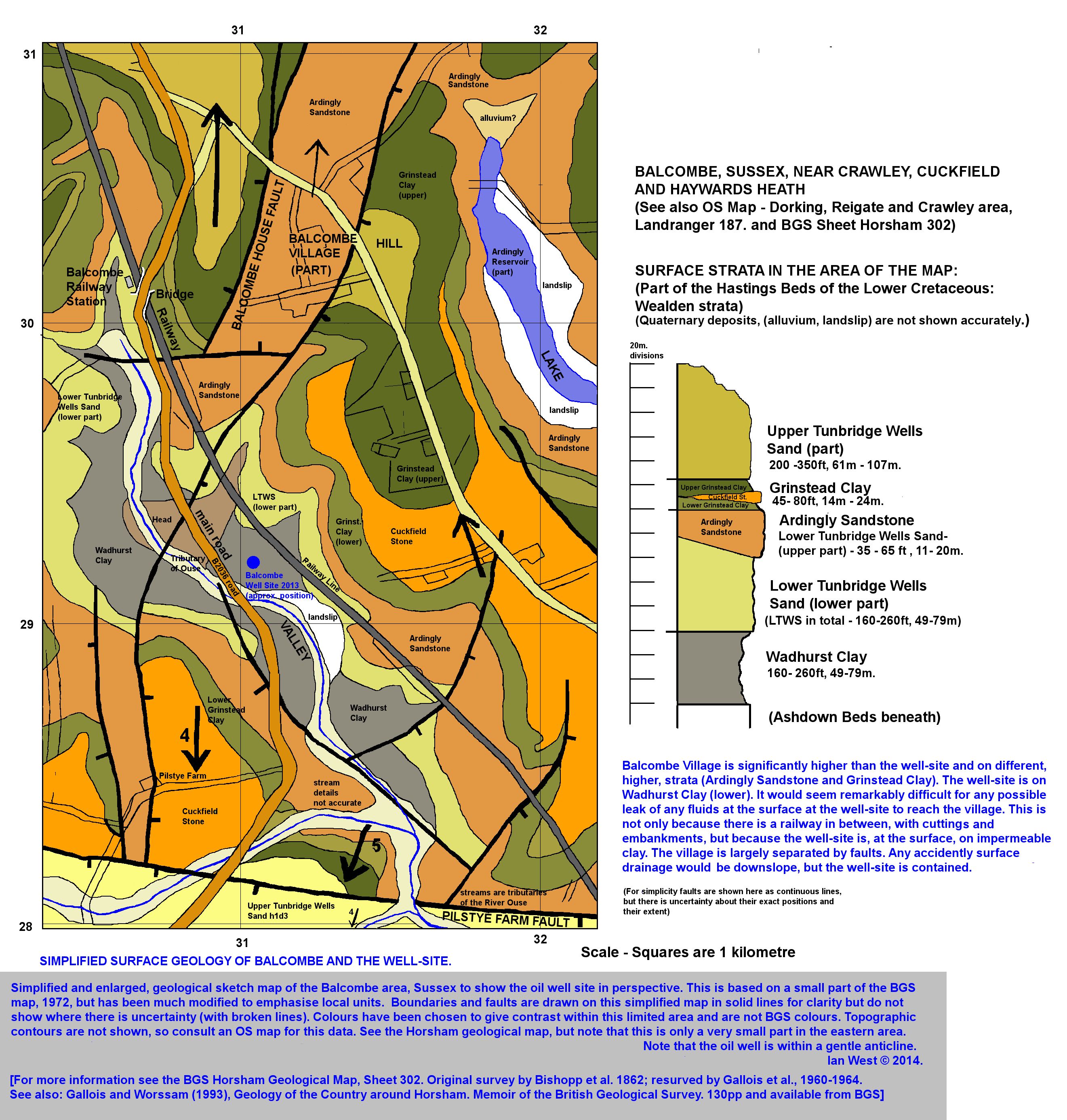
6. LOCATIONS - BALCOMBE [25th May 2017]
PGSB-6-1. Balcombe - The Unconventional Hybrid
PGSB-6-2. Balcombe - Oil and Dinosaurs
PGSB-6-3. Balcombe Location
PGSB-6-4. Balcombe - the General Scene
PGSB-6-5. Balcombe No. 1 Conoco 1986
PGSB-6-6. Balcombe - No. 2 - Near-Vertical Broehole
PGSB-6-7. Balcombe - No. 2Z - Horizontal Borehole
PGSB-6-8. Balcombe - Borehole Techniques
PGSB-6-9. Balcombe - Unconventional Hybrid Classification
PGSB-6-10. Balcombe - Expansion of Joints
PGSB-6-11. Balcombe - Acid Flushing
PGSB-6-12. Balcombe - Faulting
PGSB-6-13 Balcombe - Kimmeridge Clay - Stratigraphy and Sedimentation
PGSB-6-14. Balcombe - Kimmeridge Clay - Comparison with Dorset Coast
PGSB-6-15 Balcombe - Oil and Gas - Unconventional Hybrid Plays - More Details
PGSB-6-16 Balcombe - Oil and Gas - Additional Notes
--------------
7. LOCATIONS - HORSE HILL (NORTH OF GATWICK AIRPORT) - 6bb
PGSB-7-1. Horse Hill - Oil and Gas
8. LOCATIONS - BROCKHAM (NEAR DORKING)
PGSB-8-1. Brockham - Oil and Gas
9. LOCATIONS - FERNHURST
PGSB-9-1. FERNHURST - Kimmeridge Clay - Introduction
10. LOCATIONS - WISBOROUGH GREEN
PGSB-10-1. Wisborough Green
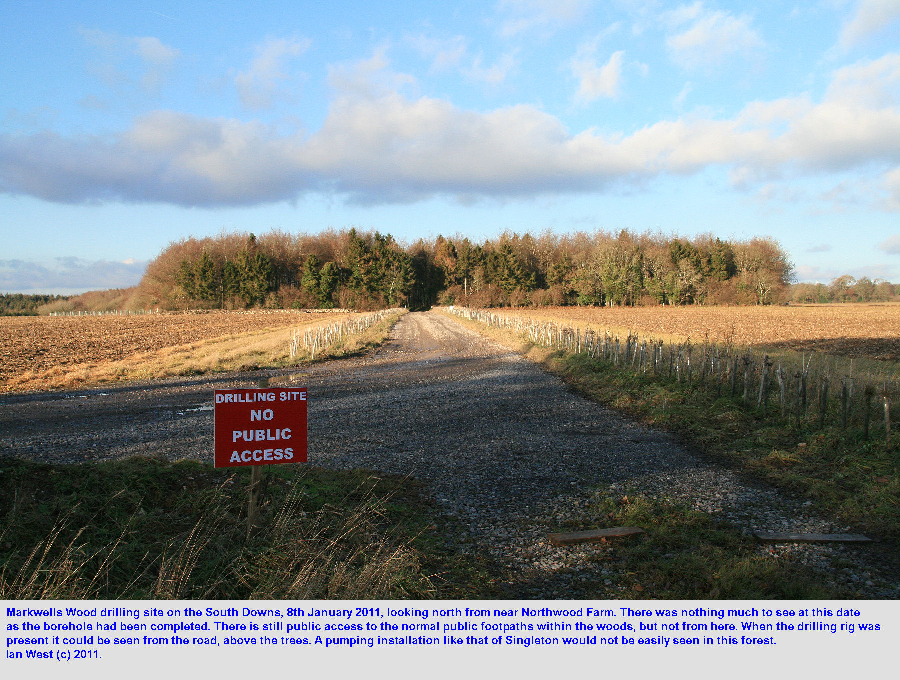
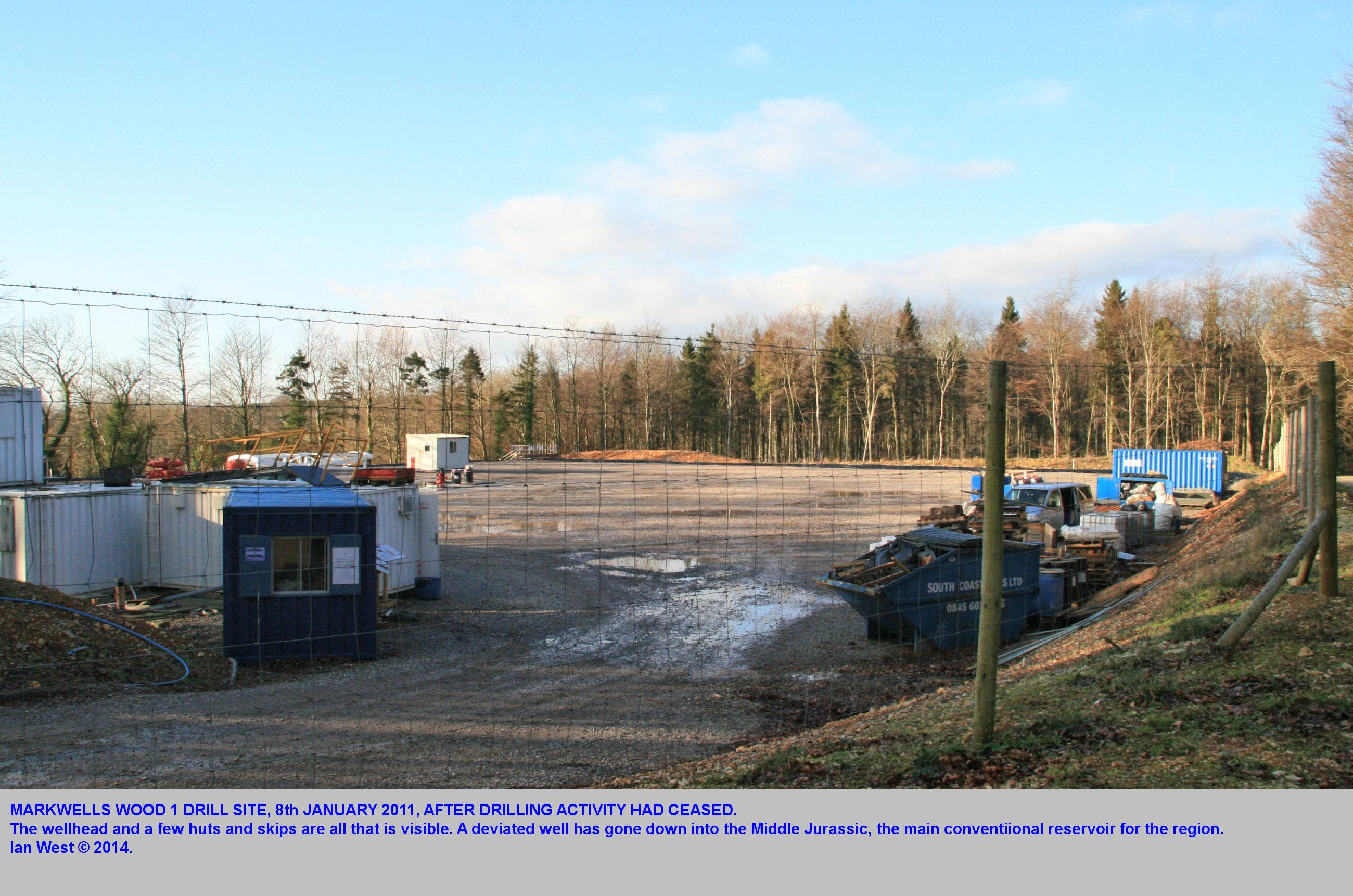
LOCATIONS - MARKWELLS WOOD
PGSB-11-1. Markwells Wood
LOCATIONS - STORRINGTON
PGSB-12-3. Storrington
LOCATIONS - BROADFORD BRIDGE
PGSB-9-1. Broadford Bridge
LOCATIONS - MIDHURST
PGSB-9-2. Midhurst, Sussex
LOCATIONS - PALMERS WOOD
PGSB-9-3. Palmers Wood, Godstone, Surrey, RH 9
LOCATIONS - LIDSEY GREAT OOLITE, OIL FIELD
PGSB-9-3a. Lidsey, Sussex, north of Bognor
LOCATIONS - MIDDLETON, SUSSEX, EXPLORATORY BOREHOLE
PGSB-9-3b. Middleton, Sussex, east of Bognor
LOCATIONS - SINGLETON
PGSB-9-4 Singleton Oilfield, West Sussex
LOCATIONS - STOCKBRIDGE OIL FIELD
PGSB-10-1 Stockbridge Oilfield, near Winchester Hampshire
LOCATIONS - WINCHESTER - MINOR EARTHQUAKE 2015
PGSB-10-2 Winchester Earthquake, Hampshire
LOCATIONS - HUMBLY GROVE OIL FIELD
PGSB-10-3 Humbly Grove Oilfied and Gathering Station, Hampshire
FOR REFERENCES:
Go to the separate website:
Bibliography and References on Petroleum Geology of the South of England, including the Weald Area.
.

.

.

0-1 INTRODUCTION - INVERSION STRUCTURES - OIL MIGRATION
Oil Migration History in Southern England summarised
.

.
1. INTRODUCTION - GENERAL
BGS REPORT ON JURASSIC SHALES IN THE WEALD
This particular webpage is merely an introduction to the petroleum geology of the western to central Weald, with particular reference to bituminous shales. It is not a research study and simply assembles some available, public information. For more detailed data, the reader should see the BGS publications on the Weald and its oil resources. See particularly the recent, quantitative account by the British Geological Survey, which is available free online. The major publication, discussed further below is freely available. It is a large report and in several parts, including extensive Appendices.
Because the oil present has presumably originated within the Weald and migrated westward, the Stockbridge Oil Field (and associated western areas) is included in this webpage.
.
ANDREWS, I.J. ET AL. (2014) THE JURASSIC SHALES OF THE WEALD BASIN: GEOLOGY AND SHALE OIL AND SHALE GAS RESOURCE ESTIMATION. 79 pp. BGS and DECC.
British Geological Survey Publication; Department of Energy and Climate Change. With 52 figures and 12 tables.

This important report is available online as a pdf file.
Search for: Jurassic Shales Weald Basin
(also if necessary add Andrews and BGS)
Or go to:
BGS_DECC_JurassicWealdShale_study_2014_MAIN_REPORT.pdf
.
[The main volume is in normal geological language and requires no technical knowledge beyond a passing aquaintance with Rock-Eval Analysis, TOC and Vitrinite Reflectance. The reader should have at least one degree in geology but this main report does not need a specialist knowledge of petroleum geology. It is suitable for the general geological public (except possibly the statistics). Non-geologists might find the text and diagrams heavy-going, but can obtain valuable conclusions from it, without difficulty.
Parts of the the Appendices, referred to below, are not so simple and require some understanding of various equations and conversions. A higher degree in petroleum geology or equivalent experience is perhaps a better qualification for the reader of this part. The general public are unlikely to read the Appendices.
.
Summary of the main report: The Jurassic Shales of the Weald Basin report: geology and shale oil and shale gas resource estimation. Page 1 et seq.
Following the publication of shale gas resource estimates for the Carboniferous Bowland-Hodder shales (Andrews 2013), this report is the second to address the potential distribution and in-place resources of unconventional oil and gas contained in the shales beneath the UK. It summarises the background geological knowledge and methodology that have enabled a preliminary in-place oil resource calculation to be undertaken for the Weald Basin and adjacent areas in southern Britain (Figure 1). No significant shale gas resource is recognised in the Jurassic of the Weald Basin.
Marine shales were deposited in the Weald Basin at several intervals during the Jurassic (c. 145-200 Ma). The basin is composed of several fault-controlled sub-basins, which form part of a wider basin that extended into northern France. It is geologically distinct from the Wessex Basin which lies to the southwest, outside of the study area.
Five units within the Jurassic of the Weald Basin contain organic-rich, marine shale: the Mid and Upper Lias Clays (Lower Jurassic) and the Oxford Clay, Corallian Clay and Kimmeridge Clay (Upper Jurassic). These attain gross shale thicknesses of up to 300 ft. ( 90 m.), 220 ft. (67 m.), 500 ft. (150 m.), 260 ft. (80 m.) and 1,800 ft (550 m.) respectively in the Weald Basin depocentre, and they contain varying amounts of organic matter. Coventional oil and gas fields in the basin attest to the capability of some of these units to produce hydrocarbons. It is possible that oil could have been generated from any or all of the five shales, but in the current model even the deepest Jurassic unit is not considered to have been sufficiently buried to have generated significant amounts of gas. Some gas has been generated in association with oil and shallow biogenic gas may also be present.
Organic-rich shales occur at two levels in the Lias (Lower Jurassic) of the Weald; these have direct equivalents in the Paris Basin, although in the Weald they fail to reach the richness found in France. In a third Lias unit, the Blue Lias (Lower Lias), total organic carbon (TOC) reaches 8% further west in the shales of the Wessex Basin, where it sources the Wytch Farm oilfield, but organic carbon contents are typically well below 2% in the equivalent limestones and shales of the study area. This contrast in organic content may result from differences in palaeogeography and organic input or preservation between the basins. The most significant organic-rich shales in the Weald Basin occur in the lowermost Oxford Clay (TOC up to 7.8%) and middle Kimmeridge Clay (TOC up to 21.3%) and these represent potential 'sweet-spots' worthy of further investigation.
None of the Jurassic shales analysed by Rock-Eval methodology has an 'oil saturation index' (SI*100/TOC) of greater than 50, i.e. much of the "oil" may be physically associated with kerogen, rather than present in pore space. This is low in comparison to shale oil producing areas in North America, so it may be tha only limited amounts of shale within the Jurassic of the Weald Basin have any potential to produce oil in commercial quantities. However, after correcting fro the evaporation of light hydrocarbons since the sample was taken, it may be that some horizons within the Mid and Upper Lias, lower Oxford Clay and Kimmeridge Clay exceed the 100 required for the oil to be 'producible'. Also the fact that oil has migrated inot conventional reservoirs suggests that optimum conditions are reached at least locally within the basin. Interpreting the presence of producible oil in the organic-rich shales allows for an in-place resource volume to be calculated wth a broad range of probabilities.
The maturity of the shales is a function of burial depth, heat flow and time. In this study, the Jurassic shales are considered mature for oil generation (vitrinite reflectance, Ro values between 0.6% and 1.1%) at depths between approximately 7,000 - 8,000 ft. (2130m. - 2440m.) and 12,000 - 13,000 ft. (3660m. - 3960m.)(where there has been minimal uplift). However, southern Britain experienced a phase of significant uplift in Cenozoic times, due to basin inversion, that has raised the mature shales by up to 6,750 ft (2060m.) to shallower present day depths than would otherwise be expected. Howver, even the Lias shales are unlikely to have attained sufficient maturity to allow for significant gas generation.
Where they have been buried to a sufficient depth for the organic material to generate oil, all five prospective shales are considered to to have some potential to form a shale oil resource analogous, but on a smaller scale, to the producing shale oil provinces of North America (e.g. Barnett, Woodford and Tuscaloosa).
Hybrid conventional/shale oil plays, with low porosity and impermeable rocks juxtaposed against mature shales may also represent favourable exploration target in the Weald Basin; these have also proven successful in the the North America (e.g. the Bakken oil system). The oil resources potentially present in these plays are not included in the in-place oil volumes in this report.
The total volume of potentially productive shale in the Weald Basin was estimated using a 3D geological model generated using seismic mapping, integrated with borehole information. This gross volume was then reduced to a net mature organic-rich shale volumen using a maximum, pre-uplift burial depth corresponding to a vitrinite reflectance cut-off of 0.6% (modelled at 7,000 ft./ 2130m., and 8,000 ft/ 2440m. The volume was further truncated upwards at two alternative levels - firstly at a depth of c. 3,300 ft. (1000m.) (as proposed by USEIA 2013) and secondly at a depth of c. 5,000 ft. (1,500m.) below land surface (as proposed by Charpentier and Cook, 2011 for shale gas). This is a regionally applied cut-off; the depth to which shale oil (or shale gas) productivity because an issue in terms of pressure and hydrogeology will need to be addressed locally.
The volumes of potentially productive shale and average oil yields were used as the input parameters for a statistical calculation (using a Monte Carlo simulation) of the in-place oil resource (see Appendix A). Two scenarios were modelled for each shale unit (Table 1).
[Table 1 follows, but it is not shown here. See the original.]
[Most optimistic estimate for the Kimmeridge Clay is 4.77 billion barrels using top of oil window at 7,000 ft. (2130m) or a much lower figure of 1.44 billion barrels using top of oil window at 8,000 ft. (2440 m) maximum burial depth. These figures are remarkably different.
The Mid Liassic Clay figures for most optimistic estimates is fairly uniform with 1.43 and 1.15 billion barrels. There is obviously much uncertainly about the Kimmeridge Clay.
Figures for all Jurassic clay are 2.2 - 4.4 - 8.6 billion barrels, with the last figure being the most optimistic.]
This study offers a range of total in-place oil resource estimates for the various Jurassic shales of the Weald Basin of 2.2 - 4.4 - 8.6 billion bbl 0.29 - 0.59 - 1.14 billion tonnes) (P90 - P50 - P10) (Table 1). It should be emphasised that these 'oil in place' figures refer to an estimate for the entire volume of oil contained in the rock formation, not how much can be recovered. It is still too early to use a more refined methodology, like the USGS's Technically Recoverable Resource "top down" estimates, which require production data from wells. In time, the drilling and testing of new wells will give an understanding of achievable, sustained production rates. The combined with other non-geological factors such as oil price, operating costs and the scale of development agreed by the local planning system, will allow estimates of the UK's producible oil reserves to be made.
There is a high degree of uncertainty in these figures. Indeed, there is a chance that there may be little or no 'free oil', given that the 'oil saturation index' is considerably less than 100 (see Jarvie 2012b) and what oil there is could be located entirely within the kerogen particles and would heating/retorting to extract it. In these circumstances, the resource could no longer be categorised in terms of 'shale oil'. The potential for hybrid plays in which oil might have migrated into tight reservoirs adjacent to mature shale is acknowledged, but the potential volumes of oil trapped in such plays in not addressed in this report.
Introduction to shale gas, shale oil and resource estimation:
Shales have long been recognised as the source rocks from which most oil has been generated. This mechanism allows for a proportion of the generated oil and gas to be expelled and to migrate into conventional reservoirs over geological time. The fact that some hydrocarbons, particularly oil, are retained in the fine-grained lithologies has now taken on a new significance. Some of these hydrocarbons occur as free oil in the shale, whilst some remain bound with the kerogen and require the shale to be retorted (i.e. heated to >350 degrees C) to extract it. This is the basic distinction between shale oil and oil shale (see Section 2.2 below).
The terms 'shale oil' and 'oil shale' are both applied to organic-rich source rocks, but the hydrocarbons are present in very different scenarios. Shale oil is mature and can be found in association with shale gas plays if the source rocks have been buried to sufficient depths. On the other hand, oil shale is immature and can either be mined at or near the surface or retorted in situ at depth. Such oil shale extraction techniques make it very unlikley that it might be exploited at depth in the Weald Basin. [bottom of p.4, continues with a table]
[end of example extract from the main report]
.
See also the associated Appendices by
Andrews, I.J., Sankey, M.J. and McCormac, M. 2014. Appendix A to F:
The Jurassic Shales of the Weald Basin: Geology and Shale Oil and Shale Gas Resource Estimation. DECC 2014. Appendix A: Estimation of the total in-place oil resource in Jurassic shales.
.
Example text from the Introduction.
"The aim of this study is to estimate the P90-P50-P101
This analysis forms an appendix to the main Weald report, which provides the detailed geological background to this shale oil play. This specific study applies a Monte Carlo simulation to a suite of input parameters, some of which come from the geology-based methodology described in the main report, and others which are based on information from published analogues. range of potential total oil-in-place volumes
for the main Jurassic shale units across the Weald area of southern Britain.
2. Introduction:
In the case of the Weald Basin, the paucity of geochemical data precludes a full understanding of free oil contents that should be necessary to estimate in-place resources. However, with regards to the use of S1 to estimate oil-in-place, it is reasonable to model two end members:
1. Use Jarvie (2012b) and as '(S1/TOC) x 100' is less than 100, assume that most/all of the measured S1 is associated with kerogen. In this scenario, the free oil density will be negligible.
2. Assume that the sorbed oil is restricted to S2 and that all the S1 is free oil. It is then possible to correct the S1 for evaporative loss (see Michael et al. 2013) and use this as the free oil density.
3. Equations 2. This report converts the S1 data from Rock-Eval analyses to an estimation of free oil yield to determine oil in-place (see Section 9.2), using Michael et al.'s (2013) equation: [continues in this style].
1.1 INTRODUCTION - AN IMPORTANT OVERVIEW FROM PROFESSOR UNDERHILL, AUGUST 2017 - REPORTED IN BBC NEWS (BY ROGER HARRABIN)
Reference: Harrabin, R. 2017. BBC NEWS ARTICLE - Business section.
Available online:
Fracking: Shale rock professor says UK gas reserves 'hyped'.
[This is an important statement from the top expert on the Petroleum Geology of south and southeastern England. See his various research papers and for background information do read, from cover to cover, the book he contributed to and edited some years back (this will enable you to see new and later developments in broad perspective;):
Underhill, J.R. 1998. Development, Evolution and Petroleum Geology of the Wessex Basin. Geological Society, Special Publication, No. 133. 420pp.
.
The BBC Article by Roger Harrabin, 2017 (17th August).
[just some brief extracts - see the full article]
.
Fracking: Shale Rock Professor says UK Gas Reserves 'Hyped'
"The gas reserves in shale rock in the UK have been "hyped", a geology professor has warned. Professor John Underhill from Herriot-Watt Universit said UK shale deposits were formed 55 million years too late to trap substantial amounts of gas."
[presumably this is a reference to Upper Jurassic, Kimmeridge Clay oil shale and it really means - actually too late, not like the Lower Jurassic and not sufficiently deeply buried to produce by burial heat substantial amounts of gas. The general implication here is obvious. Not discussed here and not likely at present is pyrolysis - which means setting the oil shale on fire - there is work in China on this method, but it is very unlikely to be used in the UK].
"He said the government would be wise to formulate a Plan B to fracking for future gas supplies."
"But the fracking firm Cuadrilla said it would determine how much gas was present from its test drilling" [there have already been numerous boreholes through the Kimmeridge Clay in the Weald!]
"Hydraulic fracturing, or fracking, is a technique designed to recover gas and oil from oil shale, a sedimentary rock found worldwide. The amount of shale gas available in the UK is acknowledged to be a great unknown. Cuadrilla said estimates from the British Geological Survey (BGS) indicated a large potential gas reserve.
Reference, below, to a British Geological Survey Statement of Andrews, I.J. 2014
The Jurassic shales of the Weald Basin: geology and shale oil and shale gas resource. British Geological Survey (this is the main report, but there is also a large Appendix.)
p.54. "This study concludes that there is no significant Jurassic shale gas potential in the Weald Basin. Even the deepest Lias shales are unlikely to have attained sufficient maturity to allow for significant gas generation. However, gas is encountered in many wells in the basin and there are several significant gas fields, some not associated with oil ----"
(go to the original for further discussion on possible sources of gas in the Weald - yes, there is gas in the Weald but it may not necessarily be directly associated with Jurassic oil shale; the gas might even be of Carboniferous origin; there is a gas question. BGS did not conclude that the gas had come from the oil shales.).
[this topic warrants further study but will left here until the full report of John Underhill is available.]
.
1.1 INTRODUCTION - GEOLOGICAL:
General
The Weald area is geologically an Inversion Structure, originally a basin that was subsequently uplifted into an anticline or elongate dome. It is of economic importance because it contains oil shales or bituminous shales at certain horizons within the Jurassic sequence. These are particularly developed within the Kimmeridge Clay Formation, but may also be present in the Lias and possibly the Oxford Clay. The Kimmeridge Clay is most important in terms of economic potential and the emphasis is on this well-known Formation. The Kimmeridge oil shale in Dorset has been used for armlets and other ornaments since the Iron Age and the Romans has a type of factory at Kimmeridge. It was much later, in the 17th century that it became used as a fuel for manufacturing alum, glass and salt. A furnace for example, burning Kimmeridge oil shale, was built in 1618. In Victorian times it was mined and Shale Oil and Shale Gas was manufactured from the Kimmeridge Blackstone. The present exploration for Shale Oil and Shale Gas in the Weald is therefore not a new procedure in southern England, although the technique of hydraulic fracturing was not available to the Victorian shale industry.
For information on the Dorset coastal exposures and the history of industrial use of Kimmeridge oil shale see the associated webpage on the Dorset coast cliff exposures and mines:
Kimmeridge - Blackstone, Oil Shale at Clavell's Hard
In the 20th century the Kimmeridge oil shale was investigated more than once for economic use. Plans to use it as fuel for the British Navy were not successful because the very high sulphur content caused an odour stink, that could not be tolerated by the crew of warships.
In 2013 and 2014 there was a new flurry of interest in once again using again this valuable but difficult mineral resource, more than 100 years after production had ceased. This time it will be hydraulically fractured and not be burnt. No doubt modern techniques will be extract the sulphur content of the oil. The location is not Dorset, where the oil shale is not thermally mature (i.e. not naturally "cooked"), but some central parts of the Weald (Balcombe, Fernhurst, Wisborough Green etc) where it has been so deeply buried (prior to uplift) that it is thermally mature.
This webpage is concerned only with the geology, so there is no serious discussion here about whether this is satisfactory from an environmental or local point of view. There is just geology for geologists and nothing more.
Incidently, the Kimmeridge Oil Shale of southern England is also of approximately the same age as the Kimmeridgian Haynesville Shale, a major hydraulic fracturing shale of the USA, where there are hundreds of wells. The Kimmeridge strata are the major source rocks of Saudi Arabia. Now an almost Kimmeridge oil shale to that of southern England has been found in Yemen and it has a very similar, hydrocarbon potential (see
Hakami et al. 2013). So parts of the Weald may be comparable in some respects to some Middle Eastern in possessing similar Jurassic source rocks.
This educational webpage discusses some aspects of the petroleum geology of the central part of the western Weald area mainly of Sussex (rather than Kent), southeast England. It is very limited in scope and very brief for such important region. It is intended to expand progressively with regard to geological information on the Kimmeridge Clay, Oxford Clay and Lias and related subject areas. This webpage and associated webpages are concerned only with the geology and are of a geological educational nature at intermediate level. The objective is to provide more information on the Jurassic shales of the Weald Basin. This webpage is related to other Kimmeridge Clay webpages, which are listed further below
This webpage is involved at all with local or environmental issues or disputes. It is purely geological and it takes use of new data which comes from the welcome new studies of the Kimmeridge oil shale both on the coast at Kimmeridge and underground in Sussex and elsewhere.
1.1a INTRODUCTION - GEOLOGICAL:
The mud diagenetic zones are shown in the diagram below, together with the general oil and gas setting regarding the western Weald area. This also applies to the southwest Isle of Wight and the adjacent offshore area between there and Durlston Head Dorset.

It is very easy to understand the generation of oil and gas in southern England, mostly in terms of an increase in temperature downwards (but do not forget the fermentation gas!). The simplified and modified diagram provided above is based partly on the work of Irwin and Curtis in the 1970s and clearly shown by Leeder (but technical data on stable isotopes has been omitted). In the cliff sections of Dorset and the Isle of Wight the younger strata, Tertiary etc (e.g. Barton Clay Formation) are mostly in the late Fermentation Zone. In the field, as in the Lower Liassic strata with the Birchi Nodules at Lyme Regis, for example, you will see the results of the 3 Fermentation Zone diagenesis (i.e. the Birchi Nodule), but with a coating of Decarboxylation beef. This fibrous calcite has been formed the nodules and probably in the lower part of the Decarboxylation Zone. The exposed strata has not in the past descended below the base of Decarboxylation and not entered the Hydrocarbon Generation Zone - 5. However, at depth in the central part of the Western Weald and also just offshore, southwest of Atherfield, Isle of Wight, the Liassic Shales and also the Kimmeridge Clay are probably in the Hydrocarbon Generation Zone. Oil and gas may migrate to various traps, often at higher levels, but mature oil shale for "fracking" (hydraulic fracturing) normally has to be in the Hydrocarbon Generation Zone - 5.
1.1a INTRODUCTION
Related Oilfield - Around Outside of the Western Weald
For information on the Middle Jurassic oilfields of the western Weald, which are in Sussex and extend into Hampshire, please see the related webpage:
Petroleum Geology of the South of England
Go specifically to sections on: Storrington, Singleton, Markwell's Wood, Horndean, Stockbridge, Winchester etc.
Those oilfields contain oil and gas which has migrated marginally and westward out of the main Weald Basin during Cretaceous times. There are similarities to the Wytch Farm and other oilfields of Dorset which are the result of Cretaceous migration of oil from the English Channel Inversion or the Portland - Isle of Wight Basin. That is rather similar to the Weald Basin but is offshore.
1.2 INTRODUCTION:
Safety
Most of this webpage is concerned with discusssing aspects of the general geology and petroleum geology of the Sussex, central Weald, region. The eastern part of the Weald into Kent is not discussed in any detail. This brief and partial account is descriptive. It is not an itinerary, and it does not suggest or recommend field trips or visits of any type to specific places. No advice is given to go to any particular place and no liability for accidents or incidents is assumed. There is no recommendation here to visit drilling sites, even if that was possible. Safety matters regarding drilling sites are not discussed here, other than that safety regulations in force at such places must be followed. Road safety in the vicinity of well-sites needs consideration, especially if heavy vehicles are entering and leaving. If geological exposures or cliffs are visited then the normal safety procedures should be observed. The Kimmeridge Clay reference section at Kimmeridge has risks of rock-fall and tidal cut-off and precautions must be taken, but they are discussed in webpages that relate to the cliffs.
1.2a INTRODUCTION:
Non-Liability
This webpage is only for student and educational use and it is not professional. It does not recommend any visiting of well sites or borehole locations, any exploration, any trespass onto private land or any hazardous activity. It is simply descriptive, as far as is feasible from available literature, maps, aerial photographs and visits to locations. Information that is obtained in one year may be superseded by later information that may or may not be included in this webpage. It makes no claims to be complete or anywhere near complete. It does not contain confidential information. It is not suitable nor intended for any use at all in connection with the value of property, land, companies etc. Do not use this website beyond its simple educational purpose and do not use it in any way commercially or in connection with financial matters or land value. No liability is assumed for misuse of this webpage or of wrong deduction having been made on the basis of any limited information here. This is not an official website representing the views of any organisation, any company or any university. The text content may change from day to day as more information becomes available, and corrections or modifications can be made at any time.
1.2b INTRODUCTION - GENERAL COMMENTS:
Hydraulic Fracturing
This webpage does not deal with hydraulic fracturing in any detail, and there is no viewpoint either for or against this technical process. It has been used in the past for many years in southern England without trouble (although in an existing well-known, "conventional" reservoir). There has been some mistaken idea that the proposed use of hydraulic fracturing at Balcombe would be the first use in the region. It may, however, be the place where this well-established technique is first used in a southern England oil shale.
The main uses and intended uses of hydraulic fracturing in southern England can be summarised as follows, in a purposely simplistic and brief explanation, intended for the non-geologist:
1. Quarrying and mining use of hydraulic fracturing by pumping water into expandible steel pillows.
This has been used in Dorset for several years and this type of hydraulic fracturing is conventional in the quarrying industry. It does not need large volumes of liquid, large trucks or large machines and it is inoccuous. It probably produces less noise than hammers and chisels. It is not easy to see if it is taking place and it is not likely to cause any objection.
2. Shale Gas Fracturing .
This is fracturing oil shales for gas. It is undertaken in oil shales that are thermally mature. These shale have been "cooked" to well above about 100 degrees centigrade by deep burial (temperature rising roughly at about 30 degrees centigrade per kilometre down). This seems to cause public objection, partly because of huge quantities of fluids required that have to be brought in by trucks, and the various chemicals and propants (that prop the fractured rock open). The recent BGS report (by Andrews et al. - see details above) suggests that there is no large gas resource in shale in the Weald. This may well be right but it is not yet proven by practical underground testing yet.
3. Shale Oil Fracturing (Important for the western Weald Inversion).
This is similar to shale gas fracturing, but from the fracturing oil can be released in rocks (e.g. Kimmeridge oil shale) that have not been so deeply buried and thus heated to a lesser extent. Two to three kilometres of burial is needed (although not necessarly now; this could be in the past). The oil may become available with or without much gas. This might be used for the western central Weald (Balcombe, Fernhurst etc.) but has not yet been fully tested.
The recent BGS report suggests that there may be in-place estimates of about 4 billion barrels of shale oil in the Jurassic rocks of the Weald. This is just an estimate, but it is quite substantial (about 8 times as much oil as in the Wytch Farm Oilfield, the largest known onshore oilfield in northwest Europe). Many oilwells and many horizontal wells and much fluid injection will be needed to get this. Transport in of fluids is a major factor, and a good road network and proximity to motorways would be useful (e.g. Balcombe). As in the environmentally successful Dorset oilfield (BP received an award for this), careful concealment of wells in forests is almost certain. It is hoped that when all this happens in Sussex too it is undertaken in the most environmentally appropriate manner. However, it must be stressed that this website is primarily concerned with geological matters, not environmental issues.
4. Oil or Gas Reservoir Improvement by Hydraulic Fracturing.
This is a case of going to a conventional oilfield, like those around the western Weald (see them from the maps), not a place with "cooked" oil shale. The reservoir rock (the Great Oolite limestones and dolomites), which is already providing some oil, is further fractured by high pressure fluids to greatly improve the porosity and permeability. Thus much more oil and gas can come out. The well sites are already there, very concealed and apparently operating normally. It is unlikely to cause environmental problems, but it can involve a very large increase in water-injection. In the future this may be so commonplace as to be a "conventional" procedure. It could happen at almost any wellsite on a small scale or on a large scale. It is not confined to the area of heated rocks in the western Weald.
5. Horizontal drilling.
This is now common, with horizontal wells of more than 11km length extending under such places as the expensive Sandbanks Peninsula in Dorset, without trouble or objection. It has been taking place for many years in Dorset, but not commonly in the western Weald area. There is already short horizontal well at the inconspicuous oilfield at Storrington, but this has no environmental relevance. For a long time a deviated well or wells at Singleton have abstracted oil or gas under the region of the village from about a mile away; this is normal procedure though, and not a truely horizontal well. It has caused no objection and there is no reason why it should.
In the future, horizontal drilling in Sussex is bound to happen on an appreciable scale, whether for conventional reservoirs or for shale oil. The Kimmeridge oil shale at Balcombe and elsewhere in the region is at surprisingly shallow depth, at least compared to many American well sites. The horizontal drilling may be at only 600 or 700 metres deep (not several kilometres). The reason for this is that the oil shale was deeply buried in Cretaceous times and has since been uplifted to fairly shallow levels in the western central Weald. The shale is rather cool now, but it has undergone the "cooking" in the past. This uplift of a former basin is known as an "Inversion Structure". There are two in the south of England. The other one is offshore, southwest of the Isle of Wight (the Portland - Wight Basin or English Channel Inversion Structure). This will not be developed as an oil or gas field under after success in Sussex.
6. The Kimmeridge Micrites.
These are very clayey (argillaceous) limestones above the Kimmeridge oil shale. The subject is a specific and interesting one and will be discussed separately in this web page. Information on the Kimmeridge micrites is fairly limited at the moment. Hydraulic fracturing of the micrites is not technically "oil shale fracking".
7. Coal Bed Methane (Carboniferous).
This is only relevant to the area of the Kent Coalfield and is not seriously discussed here. The South Wales Coalfield and the Somerset Coalfield are other places where there might be exploration for this.
8. Supplementary Note: Chichester Earthquakes.
Of relevance to hydraulic fracturing boreholes, it should not be forgotten that the Chichester area has a historic record of small earthquakes. Generally they are not of much significance to the public. There is apparently an old unconfirmed record on one of about 6 (on the old Richter Scale) that brought down chimneys. Most though are only small and might rattle a few ornaments and not cause any major damage. However the Horndean, Rowlands Castle etc boreholes are fairly close to this old epicentre. Cementation procedures in wells nowadays are of high quality, and although a minor earthquake damage has affected a fracking well in Lancashire, this is not necessarily a major issue in the Sussex-Hampshire. Perhaps it is just worth consideration, though.
It is already proven that a small earthquake of the Chichester area can affect a borehole in the region, although it is obviously a rare event. The Hunter Hill, Colbury, borehole (for water supply) in the New Forest seems to have been damaged during a local earthquake. In May 1889 there was a small earthquake, this time not at Chichester itself, but nearby at Portsmouth.
A comment was received by the hydrogeologist Mr. William Whitaker:
"Mr. T. Lloyd told me that after the slight earthquake-shock felt here on May 31st, 1889, large quantities of sand came up with the water, so as to cut out the leathers, which had to be replaced, and then to stop the supply. Before this the water had been free from clay for months."
There is no implication here that possible damage from small local earthquakes is likely to be a major issue in hydraulic fracturing, but precautions should be taken. There are probably special geological reasons (a major strike-slip fault?) for the occasional slight instability of the Chichester area, but the details will not be discussed here. Chichester Cathedral has survived for quite a long time!
1.3 INTRODUCTION:
Topographic Maps

1.4 INTRODUCTION:
Stratal Succession

The diagram above is only introductory and based on the nearby Wessex Basin rather than the Weald Basin. For the most part the sequence is similar. The vertical section is very simplified and not accurately to scale. However, it shows the general positions of the important stratigraphical units. More detail is provided in other associated webpages with regard to details of parts of the stratigraphical column. Further information will also be given below, in due course.
.
1.5 INTRODUCTION:
Geological Maps

.

.

.
It is strongly recommended that the reader with serious interest obtains the British Geological Survey Map, Horsham Sheet, No. 302, Solid and Drift. The key memoir of the BGS is Gallois and Worssam (1993), Geology of the Country around Horsham. London HMSO, 1993. 130pp. Both these can be purchased at low cost.
1.6 INTRODUCTION:
Exploration History
[contents to be added - Tait and Kent, BP etc]
1.7 INTRODUCTION:
Central Weald Basin

Kimmeridge Clay in the Central Weald Basin
1. The depocentre of the Weald Basin, the thick central area of deposition with maximum thicknesses of Jurassic strata is in East Sussex between Haywards Heath and Crawley. Balcombe, Bolney and Cowden have similar substantial thicknesses. The Kimmeridge Clay is at maximum thickness at Balcombe, with 654 metres. This compares to the section at Kimmeridge, still in fact basinal, of about 505 metres. 3. In Dorset the thickness of the main oil shale, the Blackstone, varies roughly in relation to the total thickness of the formation. Thus thick Kimmeridge Clay in the central Weald Basin may mean more oil shale.
4. There is an equivalent location in the Portland - Isle of Wight Basin (particulaly southwest of the Isle of Wight and between the Isle of Wight and the Isle of Purbeck, i.e. Swanage). A similar thickness and thermal maturity of the Kimmeridge Clay is possible, and thermal maturity would be even better in the Lias further down. Thus good discoveries on land at Balcombe might be matched in the future by similar finds offshore. 5.
1.8 INTRODUCTION:
Hydrocarbons - Introductory
Burial Diagenesis and Downward Heating in the Wessex and Weald Basins
.
It is very easy to understand the generation of oil and gas in southern England, mostly in terms of an increase in temperature downwards (but do not forget the fermentation gas!). The simplified and modified diagram provided above is based partly on the work of Irwin and Curtis in the 1970s and clearly shown by Leeder (but technical data on stable isotopes has been omitted). In the cliff sections of Dorset and the Isle of Wight the younger strata, Tertiary etc (e.g. Barton Clay Formation) are mostly in the late Fermentation Zone. In the field, as in the Lower Liassic strata with the Birchi Nodules at Lyme Regis, for example, you will see the results of the 3 Fermentation Zone diagenesis (i.e. the Birchi Nodule), but with a coating of Decarboxylation beef. This fibrous calcite has been formed the nodules and probably in the lower part of the Decarboxylation Zone. The exposed strata has not in the past descended below the base of Decarboxylation and not entered the Hydrocarbon Generation Zone - 5. However, at depth in the central part of the Western Weald and also just offshore, southwest of Atherfield, Isle of Wight, the Liassic Shales and also the Kimmeridge Clay are probably in the Hydrocarbon Generation Zone. Oil and gas may migrate to various traps, often at higher levels, but mature oil shale for "fracking" (hydraulic fracturing) normally has to be in the Hydrocarbon Generation Zone - 5.
.
.
See the following key papers:
.
Gallois, R.W. 1979. Oil Shale Resources in Great Britain. Institute of Geological Sciences [now British Geological Survey]. Southern England and South Wales, Land Survey Division. 158 pp.
British Geological Survey. 2014. A new report of shale oil resources etc in southeast England is due to be published. It has not been seen at the date of writing (31st May 2014), but information will be added later. This will be important and should be read.
Butler, M., and Pullan, C.P. 1990. Tertiary structures and hydrocarbon entrapment in the Weald Basin of southern England. In: Hardman, R.F.P. and Brooks, J. (eds), Tectonic Events Responsible for Britain's Oil and Gas Reserves, Geological Society, London, Special Publications, vol. 55, 371-391. The publication is available from the Geological Society.
The abstract of the Butler and Pullan work is given below as a brief summary of Weald structures and their relationships to hydrocarbon exploration:
The Weald Basin of southeast England was formed by rapid subsidence associated with thermal relaxation following early Mesozoic extensional block faulting. The basin appears initially to have taken the form of an easterly extension of the Wessex Basin but became the major depocentre during the Upper Jurassic and Lower Cretaceous, with associated active faulting. These movements appear to have ceased prior to Albian times and a full Upper Cretaceous cover is believed to have been deposited in a gentle downwarp which extended far beyond the confines of the Weald and Wessex Basins. Major inversion of the Weald Basin took place in the Tertiary, with both gentle regional uplift, which in the eastern part of the basin is estimated to have exceeded 5000 feet (1525 metres), and intense local uplift along pre-existing zones of weakness, which led to the formation of compressional features such as tight folds and reverse faults. Zones of Tertiary deformation appear to have been strongly influenced by underlying, particularly Hercynian, structural trends.
Lower Jurassic source rocks reached maturity in the early Cretaceous and initial migration occurred at this time, often over long distances, into traps closed by pre-Aptian faults. Tertiary tilting and uplift led to the breaching of many of these pre-existing traps and the formation of large folded closures. A second phase of hydrocarbon migration, particularly of gas, took place at this time, with significant vertical migration along fault zones. Major reservoirs located to date occur in Middle Jurassic carbonates and Upper Jurassic sandstones, but deep burial in the basin has caused considerable destruction of primary reservoir characteristics; changes in the temperature and pressure regimes and the mobilization of fluids within the basin resulting from the Tertiary uplift caused further diagenetic changes, particularly in the carbonate reservoirs.
Exploration of the Weald Basin remains at a very early stage, with a low drilling density to date. The more recent drilling has focussed on earlier structures, but traps formed or modified during the Tertiary movements represent important exploration objectives, although general deterioration in reservoir quality towards the centre and east of the basin makes large fold closures in these areas less attractive.
3.1 LIAS
Introduction
The Lower Jurassic, Lias Group is very well-known because of the classic coastal exposures at Lyme Regis and adjacent coast in Dorset, where it is 320m thick (Cope, 2012) . The Lower Lias is mostly in shale facies with alternating cementstones and shales in the Blue Lias at the base. In the cliff section there are bituminous shales in particularly in the Shales-with-Beef, well-known for a cliff fire in 1908 (the Lyme Volcano - see:
Kimmeridge and Lias Oil Shale Fires).
The Upper Lias is in sandstone facies, the
Bridport Sand Formation, and is an important reservoir rock in the Wytch Farm Oilfield.
3.2 LIAS AT THE PORTSDOWN AND HENFIELD BOREHOLES
Lower and Middle Lias (unusually thick at Portsdown)
A redrawn version of an old borehole log given further down.
Go to:
Petroleum-Geology-Weald-Shale - Portsdown and Henfield
This is an account of strata penetrated in 1936-7 by the D'Arcy Exploration Company. These are two of the oldest boreholes for petroleum exploration that took place in the south of England. No oil was discovered in either borehole. The sequence of Middle and Lower Lias at Portsdown seems fairly complete and comparable to the famous coastal sequence at Lyme Regis and adjacent Dorset coast.
The thicknesses are as follows:
Middle Lias
Portsdown - 5386 - 5672 ft (286 ft or 87m.)
Henfield - 4388 - 4500 ft (112 ft or 34m.)
Lower Lias
Portsdown - 5672 - 6474 ft (802 ft or 244m.)
Henfield - 4500 - 4890 ft (only 390 ft or 119m - about half that at Portsdown)
The authors, Taitt and Kent, commented:
"The Lower Lias shows a great difference in thickness at the two localities. At Portsdown the formation was remarkably thick, and showed an expansion of the Blue Lias beds paralleled at the time of drilling only in a borehole at Mickleton, Gloucestershire (Woodward, H.B. 1893, [The Jurassic Rocks of Britain, Vols 3,4 and 5,] p. 196). At Henfield the uppermost beds are normally developed, but the lower part of the formation is attenuated."
Lower Lias - Portsdown
[After Taitt and Kent, p. 31]
The uppermost part of the Lower Lias at Portsdown consists of grey clays, with bituminous and silty bands in the upper part [the grey bituminous clay is just beneath the base of the Middle Lias].[Compare the stratigraphical location of near the Lower Lias - Middle Lias boundary to the stratigraphical location of bituminous shales in the Posidonienschiefer (Lias Epsilon) of the Jura Mountains: see:
Bitterli (1960).]
Beneath is a hard dark calcareous clay, or marl, with thin argillaceous limestones which predominate above (5846 -6000 ft.) but subordinate below (6000 - 6100). These beds yielded Hemimicroceras aff. subplanicosta (5958 ft) and an indeterminable ammonite which may be Crucilobus (5970 ft) indicating the level of the Upper Black Ven Marls (circa raricostatum Zone). The two subdivisions which form the upper part of the Lower Lias of Dorset here measure over 400 ft (122 m.) compared with a maximum of of 170 ft. (52 m.) at outcrop.
From this level down to the Rhaetic the formation consists of a series of very argillaceous locally shelly grey limestones, in thin bands separated by subordinate dark calcareous clays. When the cores were first extracted there appeared to be no sharp line of demarcation between the limestones and clays, suggesting a gradual passage from one to the other. After exposure to the atmosphere for some time, however, the limestones became separate from the shale, and it was noticed that in many cases the boundaries crossed the bedding planes, indicating concretionary origin. Arnioceras sp. at 6122 ft. (1866 m.) indicates the semicostatum Zone, at a level approximating to the that of the Blue Lias/ Shales-with-Beef junction. The Blue Lias limestones therefore measure at least 350 ft. (107 m.) as compared with less than 100 ft. (30 m.) at Lyme Regis. Among the other fossils Spiriferina sp. and Gryphaea were obtained at 5971 ft (1820 m.); Gryphaea, Ostrea cf. liassica and Calcirhynichia ? at 6116 ft. (1864 m.) - 6132 ft (1869 m.); Gryphaea and ? Hippopodium at 6270 ft. (1911 m.); Cardinia, Modiola, Gryphaea and crinoid collumnals at 6388 ft
(1947 m.)- 6395 (1949 m.) and abundant Ostrea sp. at 6397 ft (1950 m.)
Lower Lias - Henfield
[After Taitt and Kent, p. 33]
4.1 OXFORD CLAY - BITUMINOUS SHALES
[ready for additions]
5. KIMMERIDGE CLAY - BITUMINOUS SHALES
[Notes to be added]
5.1 - KIMMERIDGE WEBPAGES
Kimmeridge Bay and Introduction
Kimmeridge - Fossils
Kimmeridge - Kimmeridge Bay to Brandy Bay and Gad Cliff
Kimmeridge - Kimmeridge Bay to Gad Cliff
Kimmeridge - East - Hen Cliff, Yellow Ledge and Cuddle
Kimmeridge Bay - Westward
Kimmeridge - BLACKSTONE, OIL SHALE at Clavell's Hard
Kimmeridge - Burning Beach, Burning Cliffs
Kimmeridge - Rope Lake Head to Freshwater Steps
Kimmeridge - Egmont Bight, Houns-tout Cliff and Chapman's
Pool
Kimmeridge - Kimmeridge Bay to Gad Cliff
Kimmeridge Clay Boreholes at Swanworth Quarry
Kimmeridge - Bibliography - Start
Kimmeridge - Bibliography Continued
Petroleum Geology of the South of England
.
5.2 KIMMERIDGE CLAY - Horizontal Drilling into a Micrite

The diagram above, based on a Cuadrilla publication, shows the general nature of the proposed borehole. Note, though, that the details of the geology in the simplified diagram (following the Cuadrilla diagram) are not necessarily precisely accurate. The thickness of the Purbeck anhydrite seems greater than usual for the area, but the stratigraphical details of the diagram are estimated, not proven. See the diagram below for stratigraphical information from previous boreholes in the area. For proven thicknesses and references to previous literature see the source publication -
Taylor et al. (2001).


.
Horizontal Drilling to 518m. [1,700 ft]
On the 23rd September 2013, Cuadrilla provided a press release, and this has been published by Professor David Smythe in:
Smythe, D. 2014. Critique of Cuadrilla's Plans and Proposals for Drilling near Balcombe, West Sussex. 19th July 2014 Update, Version 2. This is a PDF slideshow, 15pp including the title page, previously used for a lecture at Lewes and since updated. It can be downloaded from the Website given below:
David Smythe - Fracking and Faulting: the Weald .
Cuadrilla: Press Release 23 September 2013.
"On site operations involved the drilling of a vertical exploration well to an approximate depth of 2,700ft [823 m], collecting 294ft [90 m] of rock samples ("core") on the way. We also carried out a set of advanced petrophysical logs provide valuable data about the characteristics of the underground rock and the fluids contained in those rocks.
...
In addition to the vertical well a horizontal well was drilled through the middle Kimmeridge Micrite which is a band of limestone rock within the Kimmeridge Clay Formation. A total distance of some 1700ft [518 m] was achieved, drilling in a direction of just south of due west under the Balcombe estate. Using geo-steering technology, the entire 1700ft [518 m] was successfully drilled within the target limestone.
Along with the operational drilling success achieved at Balcombe the well also confirmed the presence of hydrocarbons."
5.3 KIMMERIDGE OIL SHALE AND KIMMERIDGE CLAY
- PORTSDOWN AND HENFIELD BOREHOLES
Described by Taitt and Kent (1958), the Portsdown and Henfield Boreholes, both very old, have a new interest because of oil discoveries in the Weald and the search for shale-oil. The Portsdown Borehole of 1936 was on Portsdown Hill (south side), which is north of Portsmouth. The Henfield Borehole was north of Shoreham-by-Sea and northwest of Brighton. It is almost on a line between the Storrington Borehole and the Balcombe Borehole. The Portsdown Borehole was purposely situated between the basins of Wessex to the southwest and the Weald to the east. It was placed on a Tertiary anticline because in those days comparison was being made with Tertiary, oil-bearing anticlines in Iran. BP has come from the British Persian oil company or the Anglo-Iranian Oil Company, and the geologists involved in the D'Arcy Exploration Company work in southern England had experience in Persia or Iran as it is now. Obviously the Portsdown Anticline looked particularly attractive and the geophysical techniques were not available so as to find fault traps. In addition it was not known at that time that the main oil migration was Cretaceous, and Inversion Structures, so familiar now, were not well-understood. Thus the Portsdown and Henfield Boreholes were very informative, geologically, but they did not become oil production localities. The old borehole logs are useful, once more though, now there
have been major oil discoveries around the western Weald Basin and as close to Portsdown Hill as Horndean. They provide information, too, on the oil shale horizons in the Jurassic of the Weald Basin.

The logs shown above are redrawn, with minor modifications, after
Taitt and Kent (1958). They mostly show the sequences of Kimmeridge Clay at both localities, but with a thin succession of Portland Group strata at top in both cases. A Purbeck group succession (with anhydrite at the base) is present above the Portland
sequence. The significance of this is that the basin was not showing major thinning or unconformities in the Late Jurassic to Early Cretaceous sequence. It was all relatively normal for the southern England basinal facies, but there is a differences between the Henfield section and typical Dorset basinal sequence. In particular, the Kimmeridge Clay is more sandy in parts, and it has more "limestones" (it is not known which of these are really limestones and which, if any, are dolostones. The carbonates in the Kimmeridge Clay at Kimmeride are mostly dolostones, except for the coccolith limestones in the Pectinatites pectinatus Zone of the Upper Kimmeridge Clay.
Portsdown No. 1 Borehole
This borehole penetrated 1102 feet or 336 m. of Kimmeridge Clay. This is a moderate figure, less than the 505m. in the thick Kimmeridge Clay type section at Kimmeridge on the Dorset coast, but thicker than some British inland sections.
Taitt and Kent (1958) commented, on the Kimmeridge Clay of the Portsdown Borehole. Some notes based, on their comments, but with additions and some updating, are given below.
The upper 200 feet or 61m. of the Kimmeridge is predominantly silty, and represents the slow oncoming of the Portland Sand conditions. A core at 2,757 ft. (840m.) to 2762 ft. (842m.), fairly high in the sequence and above the Blackstone and associated oil shales, yielded a number of fossils. These included the Upper Kimmeridge Clay ammonite Pectinatites sp. This is not surprising since the core would have been high in the Pectinatites Zones (P. hudlestoni or P. pectinatus). The well-known Kimmeridge Clay brachiopod Discinisca latissima (J. Sowerby) was found. This was a low-level, stationary, epifaunal suspension feeder. It it is found in the Kimmeridge cliff section in the Blackstone and elsewhere. It is a fairly common and distinctive Kimmeridge Clay fossil. Bivalves found included the mussel Musculus autissiodorensis Rding. This was a suspension feeder attached to the substrate by a byssus (and obviously when this was living the sea-floor was oxygenated). The very common, Kimmeridge Clay bivalve Protocardia morinica was found.
Beneath this was about 100 ft. (about 30m.) of calcareous clay (calcareous mudstone). Under this tough brown bituminous shale with Saccocoma was found. This meets the description of typical Kimmeridge Blackstone or oil shale, although at Kimmeridge the Bubbicum a little lower down and some other oil shales also contain the remains of the pelagic crinoid.
"Beneath is a series of dark grey calcareous clays [calcareous mudstones], with occasional thin bands of bituminous shale above and argillaceous limestone in the lower part [dolostones rather than limestones are more common at Kimmeridge in this stratigraphical part, and they were mistaken for limestones in the past - so this could be either]. (Details can be seen in the graphic log). Specimens of Rasenia cf. mutabilis, indicating the mutabilis Zone of the Lower Kimmeridge were recovered from the interval 3290 to 3307 feet. In the course of drilling at a lower level, a fallen mass of shale yielded [the ammonite] Aulacostephanus aff. pseudomutabilis and A. cf. eudoxus, indicative of the pseudomutabilis Zone. The shale was caved from an unknown level above, but is interesting in demonstrating the presence and faunal characteristics of the higher zone."
In general the Portsdown sequence is broadly similar to, but a little thinner than, that of the Kimmeridge type section. The Portsdown Anticline was active later and has not appreciably affected the Kimmeridge Clay succession here.
.
Henfield No. 1 Borehole
The Kimmeridge Clay succession in the Hencliff Borehole differs in that there is more limestone and calcareous mudstone and there is also more sand present in places. The bituminous beds are well-developed and not very different from those of the Kimmeridge coast section. The bituminous part of the sequence is in the Pectinatites Zones of the Upper Kimmeridge Clay. There is some carbonate above the Blackstone. It is not clear as to whether this is a correlative of the so-called Kimmeridge Micrite 2 (the upper one), although it seems too close to the Blackstone.
There follows a copy of the report by Taitt and Kent (1958) on the Kimmeridge Clay of the Henfield Borehole.
"The lithological succession through the Henfield Kimeridge is shown on the accompanying graphic section, and it is not necessary to detail it here. The faunal succession is largely complimentary to that at Portdown, as different levels were cored at the two localities. The uppermost 70 feet was a dark grey calcareous clay, a core from which yielded six specimens of [the ammonite] Pavlovia sp. identifiable as from the pallasioides and rotunda Zones [high, Upper Kimmeridge Clay, as seen at Chapman's Pool, near Kimmeridge, Dorset]. These fossils were only 50 - 60 feet beneath the Portland and tend to confirm the placing of the formation boundary at 1538 ft. In the later stages of drilling small brown limestone nodule casts of "Pavlovia rotunda" were noticed on several occasions. These are probably caved material from about this level, and show the presence of "rotunda nodules" like those of Dorset. A little below this level is a fine sandstone which passes down into a sandy marl. Beneath this is a series of dark clays, brown bituminous limestones [or are they brown dolostones?], sandy clay and rich rich bands of bituminous shale, the latter being particularly noticeable between 1928 and 1964 feet. A specimen of Saccocoma was obtained in cuttings sample 1956 - 1960 feet, establishing a correlation with the Dorset "Blackstone" and with the bituminous shale of Portsdown. The remainder of the series consists predominantly of dark calcareous clay [mudstone] with limestone bands which seem to be more numerous than at Portsdown. It may be noticed that at Portsdown and Henfield the limestones of the lower Kimmeridge occur in three groups in about the same position in each case. A core taken at 2094 feet yielded a perisphinctid fragment suggestive of the Subplanites Zone [Pectinatites Zones]. No cores were taken in the lower Kimmeridge, but
iridescent [i.e. aragonitic with the aragonite still preserved] ammonite fragments (suggestive of a low horizon) were observed at 2450 feet and possible mutabilis [Aulacostephanus pseudomutabilis?] zone ammonite fragments were found from 2500 feet onwards [i.e. downwards]."
[A short discussion on an unsuccessful attempt to use foraminifera for correlation follows (Lenticula, Hemicrystellaria, Rotalia etc).]
[At Portsdown there is some slightly bituminous calcareous clay in the lower part of the Oxford Clay. At Henfield in the Oxford Clay there is a thin bed of brown and richly bituminous shale near the base. The thicknesses of bituminous shale in the Portsdown and Henfield Boreholes do not look promising. There just seem to be some rare, thin units.]
5.4 KIMMERIDGE OIL SHALE - PROPERTIES
Go to Kimmeridge Oil Shale webpage (Clavell's Hard, Kimmeridge coast, Dorset) for more information on this topic.
5.4a Sulphur [Sulfur] Content of Oil Shale
The Blackstone is an unusually sulphurous rock. This is the cause of its very objectionable smell when burnt. In 1912 the British Navy, with risk of war, raised the sulphur tolerance for use of oil in naval ships from 0.75% to 3%. This seems to have been an emergency measure. However the oil produced from the Kimmeridge oil shale was found to have about twice this, at about 6 to 7% of sulphur
(Strahan, 1918). This strongly smelling oil could not be tolerated by the Navy. It was therefore unusable for naval purposes, although efforts were made to mix the sulphurous Kimmeridge shale oil with another lower-sulphur oil to bring the level down to an acceptable amount.
Later the high sulphur content of oil from Kimmeridge oil shale was confirmed by
(Gallois, 1978, Table 7, p.14). He found the sulphur in oil from six Kimmeridge oil shale samples to range from 4.3 to 8.5 per cent. There is no question that oil from Kimmeridge Oil Shale is extremely sulphurous, much more so than that from other oil shales. Probably one reason is that the oil shale is a marinite deposited from seawater as opposed to fresh, lake water, and it was deposited in reducing conditions and in contact with an abundance of calcium sulphate. The abundance of pyrite confirms the surplus of sulphide ions in the oil shale sediments.
When the Kimmeridge oil shale is heated, hydrogen sulphide is produced. A preliminary experiment recorded by
(Gallois, 1978, p. 16) reported that hydrogen sulphide is evolved from the Kimmeridge oil shale at 200 degrees C.
It was shown in
(Gallois, 1978, p. 97) that although pyrite is present as discrete crystals and as large nodules in Kimmeridge oil shale, it not, as one might expect, the major source of sulphur in shale oil from this rock. A large proportion of the sulphur was found to be within the kerogen. Studies by
Pearson et al. (1996) have shown that in Kimmeridgian strata in the Cleveland Basin, the kerogen sulphur is closely correlated with TOC [Total Organic Carbon - i.e. the proportion of organic matter] and it was found to be highest in laminated mudrocks [i.e. oil shales] consistent with most effective sulphurization of kerogen under anoxic conditions. If this is applicable to the bituminous Kimmeridge Clay of the Dorset coast then it accords with the very sulphurous nature of the Kimmeridge Blackstone which has the highest TOC in the formation. This confirms the earlier work, and again indictes that the sulphurous smell of heated Kimmeridge oil shale may be coming, at least in large part, from sulphurous kerogen, and not necessarily from pyrite.
.
5.4b Clay Mineralogy
Some clay mineralogy of the Kimmeridge oil shales and Kimmeridge Clay in general for the North Runcton (Norfolk) and Donington on Bain (Lincolnshire) boreholes has been given by Merriman in
Gallois (1978). Illite and kaolinite were found to be the major components with illite dominant. Smaller amounts of mixed-layer clay was also found. These results are unremarkable. Aragonite (from ammonite shells etc.) was frequently present and so too was pyrite.
Dolomite was also recorded from some of the Kimmeridge strata of these boreholes. This is not surprising because in Dorset, ferroan dolomite is an important constituent of the stone bands (
Bellamy (1980)). This is particularly the case in the sequence down from, and including, the Basalt Stone (Pectinatites hudlestoni Zone) is very Mg-rich. The occurrence of palygorskite in one sample from the Donington on Bain Borehole 2 is compatible with this. Palygorskite is a magnesium aluminium phyllosilicate; it occurs with dolomites and evaporites in the Lulworth Formation, Purbeck Group. There is no reason to believe that its occurrence in the Kimmeridge as a minor constituent has any connection with evaporite, but is obviously associated with the excess of Mg in much of the Kimmeridgian strata.
More specific information regarding the clay mineralogy of the Kimmeridge cliff section (Kimmeridge Bay to Encombe) was given by
Gallois (1979), p. 113. Illite was dominant, ranging from 44 to 70% (average 53%) of the less than 2 microns clay fraction. Kaolinite ranged from 15 to 27% (average 22%). Expandible (mixed layer)clay minerals ranged from 10 to 39% (average 25%). Overall this is a fairly unremarkable mix of clay minerals, and not in any way unusual for a British Jurassic clay.
5.4c Carcinogens
The Kimmeridge Blackstone and its products have no reputation for causing cancers and there is no reason to be particularly concerned. Refined oil and petrol does not seem to be any major cause for concern, but there has been discussion about shale oil obtained by heating. The topic may worth consideration because workers involved with other oil shales have suffered from this. Thus the British Geological Survey, then the Institute of Geological Sciences, considered in the publication of
Gallois (1979), p. 100 et seq the possible occurrence of carcinogens in early-stage products of the Kimmeridge oil shale. See pp. 100 et seq. in the pdf available from the Geologists's Association online (page 104 is missing) is not present. The comments on page 103 are as follows:
"The present work [i.e in 1979] suggests that carcinogenic PAHs [polycondensed aromatic hydrocarbons] may be present in Kimmeridge Clay shale oil. The concentration of these potentially harmful chemicals, if present, is likely to be small..."
Cases of skin cancer were reported from the Scottish (Carboniferous) oil shale industry. Users of shale oil in the textile industry seem to have been at risk. Apparently "615 fatal cases of scrotal cancer, a proportion of which were believed to have resulted from mineral oils were recorded in the industry between 1911 and 1938 (Henry, 1946). The Mule Spinning Regulations of 1952 therefore introduced a restriction on the use of lubricating oils to those which had been drastically refined with sulphuric acid to remove the known carcinogens."
The carcinogens are apparently not present in the natural oil shale, but they were formed during pyrolysis. They may be destroyed during refining. See the full carcinogen section in Gallois (1979) for more information on this topic. (See also Wikipedia on "Mule Spinners' Cancer).
See also:
International Agency for Research on Cancer (IARC) - Summaries & Evaluations - SHALE-OILS.
[Extract: "Inhalation of either raw oil shale or spent oil shale produced lung tumours in rats. Application of an extract of spent oil shale produced skin tumours in mice [ref: 1].
[PGSB-5-4 Kimmeridge Oil Shale - Properties contin.]
Skin application of crude oils from both low- and high-temperature retorting induced skin tumours in mice and rabbits; the high-temperature retorted oils had greater carcinogenic activity. A low-temperature crude oil produced lung tumours in mice after intratracheal instillation [ref: 1].Various fractions of shale-oils were carcinogenic when applied to the skin of mice and rabbits [ref: 1]. Shale-oil distillates, residues, blends, and commercial products of the oil-shale industry were tested in mice by skin application, producing skin tumours. Distillation fractions from less highly refined shale-oils were more carcinogenic than the more highly refined products [ref: 1]." ]
[PGSB-5-4 Kimmeridge Oil Shale - Properties contin.]
As far as is known there are no plans for pyrolysis (heating or burning of oil shale) of the Kimmeridge oil shale in the Weald, so therefore there is no reason for high temperatures to be involved. Thus there is no particular reason to believe that carcinogens might be formed. There seems to be no report of injury from carcinogens in the case of Kimmeridge oil shale. Further information on this topic with regard to other shale oils can be found on the internet.
5.5 KIMMERIDGE ARGILLACEOUS LIMESTONES - PROPERTIES


The limestones of the Upper Kimmeridge Clay (Hudlestoni Zone) are present in thick development only in the Weald Basin, and apart from some thin coccolith limestones (the White Band etc) and The Little Stone Band are not seen in the Dorset cliff sections or in boreholes of the Isle of Wight. However, there is a sequence near the base of the hudlestoni Zone which is generally fairly rich in carbonate. See the photograph above.
In the Weald they are only present in boreholes so they are not available to the field geologist in quarries or other exposures at the surface. In contrast the thin Dorset carbonates of the Kimmeridge Clay are well-known, but even there most of them are dolostones and were wrongly listed as limestones back in the past (and some of them still are!). Apart from the coccolith limestones most of the Dorset coastal Kimmeridge carbonates are ferroan microsparite dolomites, in some cases almost approaching ankerite. The well-known Basalt Stone of the Hudlestoni Zone is not a limestone but it an argillaceous dolostone. Petrographic and geochemical characteristics have been given by Bellamy (1977; 1980).
The details of the brown argillaceous limestones in the Huddlestoni Zone above the oil shale in the central Weald Basin are not know to the author at present [2013]. It is quite possible that they have affinities with the Short Joint Coal of the Kimmeridge type section (with coccoliths and elongate calcite) and particularly the dolomitic elongate-calcite limestones of the western Kimmeridge Clay section at Ringstead. The calcite of this is distinctive. It is of spindle shaped calcite crystals of microsparite size (not micrite) which can range from ferroan to non-ferroan. These distinctive crystals are associated with some dolomite crystals and with coccoliths. A similar lithology is also known from elsewhere in the Kimmeridge Clay, including Yorkshire, and it is also present in the Oxford Clay. It is not known to the author whether the Kimmeridge Clay limestone above the oil shale is similar to this or not, but it might well be so. This will be corrected if further information proves that it not of this type.
Bellamy (1980) has described bed R11 of the Upper Kimmeridge Clay of Ringstead as a typical example. He subjected this bed to detailed petrographic and geochemical analysis. It is a discontinuous, argillaceous carbonate bed outcropping above the Kimmeridge Blackstone or oil shale and below the coccolith limestone, the White Band (Huddlestoni) at Ringstead. It is stratigraphically from the appropriate part of the sequence.
5.6 KIMMERIDGE COCCOLITH MICRITES
Introduction
Micrite (i.e. microcrystalline limestone) is a limestone consists of minute calcite crystals generally less than 4 microns (4µ). This is less than 4 x a thousanth of a millimetre. A common example, although, in fact of a special type, is chalk. Micrites are lithified carbonate muds. Although initially a soft, fine-grained white mud, the calcite of micrites can become compacted, lithified and in some cases partly recrystallised into a coarser calcitic fabric. In other words the initial white mud can be converted with burial and time into chalk, or with deeper burial and/or tectonic activity into hard, practically non-porous limestone.
Carbonate muds accumulate in various modern environments. They are mostly formed in warm or fairly warm sea or lagoon areas, with tropical, subtropical or Mediterranean climates. The Kimmeridge Clay environment was a fairly deep, but not oceanic, sea at about 34 degrees N (the equator has been slowly moving away to the south, and the Weald area was fairly warm in Jurassic times). The particular type of micrite present in the Kimmeridge Clay of Balcombe and other parts of the Weald is a lithified coccolith ooze, that is probably quite argillaceous (clayey). It is slightly unusual because it is similar to a deep ocean ooze, but was formed in only a local (Weald-wide) sea depression, not in a deep ocean.
Its composition is believed to be broadly similar to that of the White Stone Bands of the Kimmeridge coast cliff sections. These, too are coccolith micrites. The most notable of them, the White Stone Band of the Pectinatus Zone is present not only in Dorset but also in the Weald area, and it can be recognised from the gamma ray and sonic log at Balcombe. The White Stone Band is a useful marker about the upper Kimmeridge Clay Micrite.
5.7 KIMMERIDGE COCCOLITH MICRITES - CONTINUED
Lithology of the Upper Micrite - a Coccolith Micrite Possibility.
The possibility that the limestones are elongate-calcite limestone has been briefly discussed above. Another possibility is that they are coccolith micrites (or some intermediate) which occur in the Huddlestoni Zone in the Kimmeridge type section. Thus the coccolith micrites of the Kimmeridge Clay are briefly discussed.
According to the Non-Technical Summary of the Cuadrilla Environmental Permit Application (June, 2013) "the wellbore is planned to drill through the Micrite which is [here] an argillaceous carbonate. The Celtique Energie project report on the proposed Fernhurst Borehole makes it clear that it is an argillaceous coccolith micrite, as might be expected.
This micrite is the upper of the two micrites in the Huddlestoni Zone of the Upper Kimmeridge Clay at Balcombe (and the same at Fernhurst). This is "Middle Kimmeridge Micrite 2" or in Cuadrilla terms "Kimmeridge Micrite I" above the "Kimmeridge Micrite J" (Middle Kimmeridge Micrite 1).Now Kimmeridge micrites can be coccolith micrites and usually are. An SEM photomicrograph of the most well-known one of these, the White Stone Band of the Pectinatus Zone at Kimmeridge is shown below. This is not a surprising lithofacies for the Kimmeridge Clay, but the special feature of the Weald Upper Micrite is not only that it is extremely fine-grained but also it is argillaceous. Argillaceous coccolith micrites are not used as conventional reservoir rocks in general in southern England. Even if they have adequate porosity, the permeability in such a fine-grained rock would be remarkably low and unsatisfactory for normal reservoir purposes.

The example shown above is a very pure micrite of coccoliths, i.e. almost pure calcium carbonate. It is not argillaceous, but is associated with thin oil shales. It is thus organic-rich. Notice that the porosity is relatively high, but because of the very small size of the pores the permeability may be very low. This situation applies to the thin coccolith micrites of the Pectinatus Zone of the Kimmeridge Cliffs.

Shown above for comparison and contrast is a Jurassic coccolith micrite with well-developed, micritic-scale, cementation. This shows coccolith shields rather than coccospheres (both are present in the Kimmeridge coccolith micrites). This example has very low porosity and permeability and is not a good reservoir rock, even with hydraulic fracturing. Notice that it also lack clay minerals and obvious kerogen.
(Further Note: On page 5 of the Non-Technical Summary of the Cuadrilla Environmental Permit Application, it states that "the well is planned to be drilled through the Micrite which is an argillaceous carbonate". So this clearly states that it is not a pure calcium carbonate micrite. It differs from the photograph above in containing clay minerals. This is what those familiar with the Kimmeridge cliff sections would expect. The gamma ray and sonic logs and for the very similar Bolney Borehole, shown in
Gallois and Worssam (1993) seem to confirm this, and in the Bolney Borehole the "Micrites" are labelled as "Calcareous Mudstone".)
5.8 KIMMERIDGE CLAY - POROSITIES AND PERMEABILITIES
Basic Principles

The porosity of a rock is simply the percentage of pore space. Obviously this is very high in a poorly-cemented sandstone. It could hold water like a sponge. A solid, almost non-porous rock such as granite can hardly hold any water. The same principle applies to oil and to gas. The matter is not really entirely simple though, because in practice many oil reservoir rocks also have films of water around the grains, so the oil does not fill all the available space.
The practical value of an oil or gas reservoir depends on trapping of the hydrocarbons in a dome or fault structure. In conventional oil or gas production suitable closed structures have to be found. In these the oil or gas can move upward above water and be pumped out (or it may flow out) from the top.
In unconventional oil or gas exploration the oil or gas is in minute pores and will not flow out easily. In other words the porosity might be as high as in a conventional reservoir, but the permeability, the extent to which the fluid can flow, may be extremely low. Fine-grained rocks with minute pores, often partially blocks by flakes of clay were not used in the past as reservoir rocks. Now there are methods such as using hydraulic fracturing to open up fissures so that the fluids can flow out of the minute pores and travel to the oil well.
To understand this further the nature of the miniature pores needs investigating. In the case of Balcombe, it is known that the rock, part of the Kimmeridge Clay succession, is a micrite. It is very unlikely to be a pure micrite but the percentage of clay minerals present is not yet publicly known. The rock is probably an argillaceous (clayey) coccolith micrite (i.e. very fine-grained limestone). A further complication is the probable presence of kerogen, a brown waxy organic substance, and a potential source of oil. This substance can block pores.
5.9 KIMMERIDGE CLAY - POROSITIES AND PERMEABILITIES continued
Permeability
Permeability in oil-bearing rocks indicates the relative ease with which oil will flow through the rock. Most sandstones are very permeable; granites have extremely low permeabilities and may be impermeable for practical purposes. Limestones can vary greatly from low permeability in a hard, well-cemented limestone without much porosity (like some of the British Carboniferous Limestone) to high permeability in a porous oolite (such as the Portland Stone).
In terms of petroleum geology, permeability is is usually measured in millidarcies. A millidarcy is the permeability unit "darcy" divided by a thousand. The term "darcy" comes from water supply or hydrogeological studies based on the work of Henry Darcy. This French Engineer, lived from 1803 to 1858. He built a pressurised water distribution system for Dijon, France, that was very advanced and successful for its time. His principles can be applied to rocks with regard to water and they can also be applied to rocks containing oil.
Technically, a darcy is "the permeability that will allow a flow of 1 cubic centimeter per second of a fluid with 1 centipoise viscosity (resistance to flow) through a distance of 1 centimeter through an area of 1 square centimeter under a differential pressure of 1 atmosphere".

Darcy's Law can be written in several different ways but a simple version, is given below. In petroleum geology the permeability in millidarcies is a measure of the relative ease of oil flow through a rock. A millidarcy (mD) is equal to 0.001 darcy and a microdarcy (µD) equals 0.000001 darcy.
The nanodarcy is a minute unit that is only 1 x 10⁻⁹ of a darcy. In some places parts of the Kimmeridge Clay can have porosity values of about 20%, quiet substantial, but with permeabilities of only about 5 nannodarcys. This is normal for shales. It is not noted though that the Upper Micrite of the Kimmeridge Clay is a actually a limestone of very small particle size but probably with clay and kerogen. Thus the permeability, although low, may be higher than in the pure shales.
.
RESERVOIR ROCKS OF THE WEALD AREA
RESERVOIR ROCKS (in preparation)
5-10 SHERWOOD SANDSTONE RESERVOIRS
5-11 INFERIOR OOLITE RESERVOIRS
5-12 GREAT OOLITE RESERVOIRS
Thickness of Great Oolite and Oil Well Locations

The White Carbonate Shoal Sands (Middle Jurassic, Western Weald)

Many factors are involved in the presence of oil fields in the western Weald area of West Sussex and East Hampshire. One of these factors is the existence of a good reservoir rock. This is the Great Oolite of the Middle Jurassic, the major oolitic limestone of the Cotswold and Bath area. The distribution of the white sands of the ooid shoal in the warm blue water of about 165 million years ago is shown above in a modified version of a palaeogeographic map by Sellwood et al. (1989).
(If it existed today it would be a holiday resort, but rather dangerous with ichthyosaurs and plesiosaurs in addition to sharks and crocodiles.) There are obvious similarities to the modern Florida - Bahamas area (also to the southern Arabian Gulf but that is too arid for good comparison). At this time, of course, the southern British region was still attached to America, and was part of Pangaea (stretched, pulled apart a little and soon to open!).
.
5-13 CORALLIAN RESERVOIRS
This is a potential minor reservoir. Further information will be added.
.
5-14 PORTLAND GROUP RESERVOIRS
The Portland Group contains gas in places. Further details will be added.
5-15 PURBECK GROUP RESERVOIRS
The Purbeck Group contains gas in places in parts of the Weald. Further details will be provided.
.
5-16 WEALDEN GROUP RESERVOIRS
The Wealden strata of the Weald and of Dorset contain oil seeps, because these non-marine strata were deposited at the main time of migration of oil from the source rocks to the reservoirs. The Wealden does not usually contain quantities of economic value.

Lees and Taitt (1945).
Reeves (1949).
.
5-17 HIGHER RESERVOIRS
[This heading is retained for possible future use, but no higher reservoirs are known or discussed here.]
.
LOCATIONS - SPECIFIC BOREHOLE LOCALITIES
6.0 BALCOMBE, - AN UNCONVENTIONAL HYBRID
(With a naturally fractured reservoir above Kimmeridge oil shale)
The Balcombe, Sussex, hydrocarbon exploration has in the past (2013) received great publicity but it may have been misunderstood to some extent by the public. It has wrongly been regarded by some as a shale-gas fracking locality. The Jurassic shales, particularly the Kimmeridge Clay (relatively high in the sequence), are not thermally mature for substantial shale-gas. They have never been very deeply buried. However, in the central Western Weald (Balcombe and adjacent) they have been in the depth zone for generation of oil. This has to some extent migrated in the Cretaceous from the centre out to the western fringes of the Weald region (e.g. Horndean, Winchester-Stockbridge, Humbly Grove, Singleton etc.).
Oil should be present within the Kimmeridge Clay oil shale in the western central zone of the Weald Basin. It has been fairly deeply buried. How much is kerogen and how much is liquid oil is not known at present. The oil exploration in 2014 is directed towards the Kimmeridge Micrite 2. It is a fine-grained, argillaceous limestone with some porosity, but perhaps not particularly good permeability within the rock. However, the matter is complicated because of the presence of joints, which can be conduits, and it may be classified as an NFR, a naturally fractured reservoir. The details are not publicly known though. Some simplified diagrams and relevant photographs follow:


Upper Kimmeridge Clay, Micrite 2 is in the Hudlestoni Zone. It is a short distance above the main Kimmeridge Oil Shale or Blackstone (top of the Wheatleyensis Zone). Above, for illustration, a part of the Hudlestone Zone at Rope Lake Head, east of Kimmeridge, Dorset, is shown. This includes the Little Stone Band and, this, although very thin, is the nearest equivalent on the Dorset coast to the Kimmeridge Micrite 2 of Sussex. The unconventional hybrid scheme of oil production at Balcombe is based on opening joints in a Hudlestoni carbonate. Here at Rope Lake Head, Kimmeridge, there are rectilear joints. They are almost square. On a limited scale, they are not stratabound because they continue from shale through a thin limestone into shale again. However, on a larger scale there are considerable stratal differences in jointing; it is very close-spaced in shales and much wider spaced in well-cemented, hard, dolostones.
For more information on stratabound and non-stratabound joints, see the very useful paper:
Bratton et al., 2006. The Nature of Naturally Fractured Reservoirs. This paper does not deal directly with the strata in question. However its description and discussion seems to suggest that Kimmeridge Micrite 2, with its joint system, is a naturally fractured reservoir or an NFR. Tectonism has not been severe and thus Sigma One, the maximum principal stress direction, has probably been near-vertical. This is the case at Kimmeridge on the coast in most beds, but excluding some dolostones with diagenetic expansion features (e.g. The Flats Dolostone Bed).

The Kimmeridge Micrite 2 at Balcombe is above the main Kimmeridge oil shale. Oil generated in the early to mid-Cretaceous may have to some extent migrated into the overlying Kimmeridge Micrite 2. It is very likely that jointing had taken place before maximum burial. Thus it was probably a potential NFR or potential a naturally fractured reservoir before oil generation. Note, incidently, that while most joint development will occurred under deep burial, note that some opening of the joints might have occurred in the post-Early Cretaceous uplift; this is a discussion of oil migration, though, rather than oil recovery.]
Thus the current exploration (2014) is now in this limestone, rather than the oil shale. Producing from a low-permeability reservoir above oil shale is know as hybrid production. The effective permeability of the micrites has to be improved. Theoretically this could be done by full hydraulic fracturing. However, a more modest plan is apparently to open up joints, as shown in the illustration above. These are closely spaced in Kimmeridge strata in general, usually occurring at intervals of about half a metre. They are likely to be present in the Micrite 2. High water pressure may be able to open these up without the more severe process of full hydraulic fracturing. This more moderate process has been referred to as an unconventional hybrid. There has been reference to this in relation to the Kimmeridge oil shale of southern England, as at Balcombe. The procedures so far at Balcombe include a 600 metre long, horizontal borehole which extends WSW from the Lower Stumble Well site. It is situated on the axis of a gentle anticline, with some faults in the general vicinity.
The Balcombe hybrid play seems to have been been mentioned in the BGS report on the Weald Area and in an American paper, but without specifically naming the village. See the following:
"The potential for hybrid plays in which oil might have migrated into tight reservoirs adjacent to mature shale is acknowledged, but the potential volumes of oil trapped in such plays is not addressed in this report." (P. 4 in: Andrews, I. J. 2014. The Jurassic Shales of the Weald Basin: geology and shale oil and shale gas resource. DECC and British Geological Survey.)
Jarvie, D. M. 2011. Unconventional Oil Petroleum Systems: Shales and Shale Hybrids. By Daniel M. Jarvie. This also refers briefly to unconventional hybrid plays in the Kimmeridge Clay of southern England..
[See also:
Balcombe - Oil and Gas - Unconventional Hybrid Plays - More Details]
6.0a BALCOMBE, - OIL AND DINOSAURS
Balcombe and the well-site is between two places (Whitemans Green and Tilgate Forest) where dinosaur remains were first found (Mantell). In southern England (Weald and Isle of Wight) dinosaur remains are abundant above the general locations of thermally mature oil shale. There is a connection.
The reason for this are probably as follows. Above the Permo-Trias the first phase of an Inversion Structure such as that of the Weald Basin (Weald Inversion Structure) or the Portland - Isle of Wight Basin (English Channel Inversion Stucture)is one of Jurassic marine sediment accumulation. This takes about 55 million years. In the Inversion Structure the sediment thickness accumulated very much more than on the shelf. The central basin Kimmeridge oil shale thickness for example is about two or three times as thick as that on the shelf. This thickness variations is fairly consistant throughout the Jurassic.
In the Lower Cretaceous up-faulting on the northern margins of the Inversions started to increase (with minor seismites). This leads to erosion and reworking on the shelf with a feed of reworked pebbles of Kimmeridge phosphates etc, and older material into the basin as thin pebble beds. At about this time the major Wealden clastic sedimentation started. Burial depths began to cause thermal maturity in deeper Jurassic shales (and this continues with Kimmeridge maturity rather later than Lias). Also, because the faulting started, oil and gas seeps became active and there was probably some loss from the early oil reserves.
With marginal faults now well-defined and with active downwarping, the basins are now filled with fluvial sediments. This was derived partly from a distance in the west and partly from the nearer upfaulted margins. As is very well-known, the pebbles from the London-Brabant upland to the north have been much studied by Allen. Into the basin come large quantities of coniferous trees and other vegetational debris. Numerous remains of land animals were also washed towards the subsiding basin centre. One such area is the Weald around Balcombe. Another is the southwest Isle of Wight. Both are characterised by a great thickness of Wealden clastics and both are over thick Jurassics, with the consequence of thermally mature Jurassic oil shales.
So dinosaur remains are found in greatest number in the basin centres, and at the same places the bituminous shales have been deepest buried and therefore most thermally mature. This is why Mantell and his wife made the early finds near Balcombe.
The later history, the compressional Alpine phase, of the Inversion Structures is well-known, but not discussed in detail here. It followed a quiet phase of steady subsidence continued from 113 million years to 41 million BP. In the Tertiary, the Balcombe region has been uplifted by more than a kilometre (although it seems static now). Because of the uplift, the oil shales were brought up to within a kilometre of the surface. That is why the drilling for shale oil in the Weald is very shallow compared to American fracking.
6.1 BALCOMBE, MID-SUSSEX VILLAGE - WELL SITE LOCATION (AND INTRODUCTORY GEOLOGICAL MAPS)
.

.

.

.

The reason for the apparent simplicity of the Balcombe area is because is in the centre of an Inversion Structure. Because of the major uplift in the Tertiary (Eocene to Miocene) the Lower Cretaceous is exposed at the surface and there is no late Cretaceous or Tertiary overburden. Everything is below the basal Aptian unconformity (the Late Cimmerian Unconformity). Thus the Lower Cretaceous strata are broadly parallel in terms of structure to the underlying Jurassic. There is no late Cretaceous or Tertiary overburden producing complications.
(For some additional information on the details of Balcombe petroleum geology etc, including faults, see:
David Smythe - Faulting and Fracking: the Weald. )
6.2 BALCOMBE, MID-SUSSEX VILLAGE - THE GENERAL LOCATION

.

.

.

.

.

.

.
Balcombe has become a famous name in England, because it is the first place in the Weald area of the south of England where, supposedly, hydraulic fracturing was planned. However, this has not taken place. Balcombe has received much publicity in the press, particularly in the year 2013. The wellsite is down a road through forest and fairly close to a busy railway line. It is not close to most of the houses of the village.
The site has strata thermally mature for oil, but not for gas, which requires deeper burial. There is hydrocarbon source rock potential in the area regarding the Lias, the Oxford Clay and the Kimmeridge Clay within the deep Weald Basin. The oil shale of the Kimmeridge Clay is particularly important. The deepest and most mature of the Jurassic source rocks is the Lower Lias.

.
Also:
SEE AERIAL PHOTOGRAPHS IN EXTERNAL WEBSITE
Visit external website - Capital Bay 2013:
See:
Balcombe - aerial photographs of the Balcombe fracking wellsite when in use in 2013.
There are excellent aerial photographs in that website and they are copyright of Jim Bennett. They shown the number of trucks, huts and machines needed in addition to the drilling rig.
.
Balcombe is, of course, the most well-known locality for exploration for shale oil in the south of England. The environmental dispute here is well-known and is not discussed in any detail in this webpage. Records of activities and problems are in the press, particularly for the year 2013. Part of an example article is shown above. Search online for more information. There has been in early 2014 a local protest and a very thorough and detailed objection from residents of Balcombe. This objection has been over-ruled by the authorities and drilling will go ahead again here in the near future.
6.3 BALCOMBE No. 1 WELL - Conoco 1986
19th September 1986, PL 244, 49.800W, 49.200N, Balcombe, West Sussex, Conoco.

This Balcombe No.1 borehole was drilled by Conoco to 1724m before finally being plugged and abandoned. Dr. Tony Grindrod tells me that two cores were taken in the Great Oolite from 4717 feet (1437m.) to 4834 feet (1473m.); see photograph above. The new Balcombe No.2 borehole is to go only 900m. In other words the new one is a rather shallow borehole of only about half the depth of the previous borehole and not deep enough to reach the main oil reservoirs of the Weald in the Great Oolite. The No.2 borehole, contrasts with No. 1 in that it is targeting a Kimmeridge argillaceous micrite (not very deep), probably of low porosity and permeability, and not something of interest in any of the previous oil exploration in the region. The Kimmeridge Clay has not been considered as a potential reservoir with regard to any previous borehole in Britain. Many boreholes have gone through it. Balcombe No.1 borehole has actually penetrated the "Kimmeridge micrite" or "Kimmeridge Limestone". Balcome No. 2 is going through the same strata as did Balcombe No. 1. Obviously it is difficult to understand the purpose in drilling a new borehole at the same site but to a shallower depth, unless some different technique to improve porosity and permeability is used (hydraulic fracturing or acidizing or both?).
However, Cuadrilla have apparently stated as follows, from papers quoted on the:
Bishop Hill website .
"Balcombe-2 in PEDL-244 is planned as essentially a re-evaluation of the upper section of the Balcombe-1 well, drilled some 10m away on the same site in 1986. Balcombe-1 was drilled to a total depth of 5560ft into the Upper Lias, and was plugged and abandoned. The plan now is to drill a vertical pilot hole termed 'Balcombe-2' followed by a planned sidetrack to horizontal for non-hydraulically fractured completion and production testing."
6.2a BALCOMBE No. 2 WELL
2nd August, 2013, PEDL244, 50.350W, 49.340N, Balcombe, West Sussex, Cuadrilla Resources Limited.
This was a near-vertical well.
[further notes will be added]
6.2b BALCOMBE No. 2Z WELL
5th September, 2013, PEDL244, 50.353W, 49.3360N, Balcombe, West Sussex, Cuadrilla Balcombe Limited.
This was a well a long horizontal section in the Kimmeridge Micrite 2.
[further notes will be added.]
6.3 BALCOMBE - Borehole Technique
Possible Techniques for Obtaining Oil and/or Gas in the Central Weald Basin
.
Below is a simple outline, introductory classification of the main methods for obtaining oil and gas from rocks. This is show the Balcombe Kimmeridge Micrite source within broad perspective.
1. Conventional oil reservoirs in traps, mostly sandstones and
limestones with good porosity and permeability. Examples - Structures
in Sherwood Sandstone and Bridport Sands in Dorset and offshore,
also Middle Jurassic limestones and dolomites in the western Weald (lower than the Kimmeridge Clay of Balcombe).
2. Unconventional - Thermally mature (i.e. naturally heated) oil
shales or shaley limestones with a high organic content. Presumably the aim is to produce oil and gas from these at Balcombe and Fernhurst and other places in between and around the area. Only in certain areas such as the central Weald Basin (Balcombe etc) and offshore from Dorset and Hampshire and the Isle of Wight are such rocks available. Thermally mature micrite (a type of limestone) in the Upper Jurassic Kimmeridge Clay is the subject of discussion in this webpage.
2a. Unconventional Hybrid - the scheme for Balcombe. More complicated systems of various types. In this case there is use of a micrite reservoir that is above the Kimmeridge oil shale source rock. High water pressures, perhaps with injection of acid or other chemical fluids. Joints may be opened by high pressure, but true hydraulic fracturing is not apparently to take place (as in September 2014). No plans have been announced to deal with the Kimmeridge oil shale source rock, and this may not necessarily be hydraulically fractured or treated in any other way.
3. Unconventional - Thermally immature oil shales. These may have
biogenic gas in some cases but details are not known. This is not discussed in any detail here.
4. Unconventional - Pyrolysis (effectively setting oil shale on fire
underground to use the heat to release gas). This is very hazardous with many problems; it is not planned for the Weald area and it is not discussed here.
.
Progress in 2014
.
A fairly shallow borehole has been drilled to only 900m vertically at Balcombe. This is only to the Kimmeridge Clay in the Upper Jurassic and is to only about half the depth of a normal Sherwood Sandstone Borehole in Dorset. It has been extended horizontally as Balcombe 2Z. See a simplified comparison diagram below.

The large-scale operations which have proceeding without any appreciable problems at Wytch Farm Dorset for a very long time (starting in the 1970s). At one stage the very successful environmental concealment of the with the drilling and production in Dorset resulted in BP being awarded a prize. Thus although the scale of oil industry work in Dorset is that of the world's largest known onshore oilfield it has had public approval. The much smaller scale work at Balcombe in Sussex seems to have been less welcomed , probably because hydraulic fracturing of a limestone (not shale) is thought to be a process which might take place. Environmental may be mentioned in passing but are not discussed here in detail as the emphasis and objective in this webpage is new information on geology.
[For some limited information on the highly successful Wytch Farm oilfield go to:
Petroleum Geology, South of England.]
.
6.3a BALCOMBE - Borehole Technique - Unconventional Hybrid
Casing and Cementation
The following comments regarding Pennsylvania wells provide some interesting background, but there is no suggestion that these risks are at this level in the probably more regulated, UK. The situation may be much safer here.[Note that the Devonian Marcellus Shale is at about 2km depth, compared with the Kimmeridge oil shale at Balcombe which near 1km depth; the organic rich Utica Shale of Ordovician age is at about 3.5 km below the surface. With much greater depths than at Balcombe, wells will be much longer and water pressures much higher. Thus a very close comparison should not be made.]
For a discussion of casing and cementation risk associated with conventional and unconventional wells in Pennsylvania, see:
Ingraffea et al. (2014) Assessment and risk analysis of casing and cement impairment in oil and gas wells in Pennsylvania, 2000-2012 .
Note the rather surprising conclusions regarding Pennsylvanian wells on p. 8 of this paper, although there is no reason to believe that the situation would be so unsatisfactory in the UK. This interesting paper is available free on the internet. Go to:
Ingraffea et al. 2014.
"Pennsylvania state inspection records show compromised cement and/or casing integrity in 0.7 - 9.1% of the active oil and gas wells drilled since 2000, with 1.6 to 2.7 fold higher risk in unconventional wells spudded since 2009 relative to conventional well types. Hazard modelling suggests that the cumulative loss of structural integrity in wells across the state may be actually be slightly higher than this, and upward of 12% for unconventional wells drilled since January 2009. The wide range of estimates is influenced by significantly higher rates of impairment in wells spudded in the NE of the state (average of 12.5%, range 2.2 - 50%), with predicted cumulative hazards exceeding 40% (Fig. 5 and 6)."
See also:
Osborn et al. 2011. Methane contamination of drinking water accompanying gas-well drilling and hydraulic fracturing. .
and also:
Davies, et al., 2014. Oil and gas wellls and their integrity: implications for shale and unconventional resource exploitation.
The above papers provide clear and helpful information for the geological reader.
See also the various popular, press reports on these topic, intended for the general public. For example:
McGrath, M. 2014. Weak wells not fracking caused US gas leaks into water. BBC News, Science and Environment, 15th September 2014.
Weak wells not fracking caused US gas leaks into water.]
6.3aa BALCOMBE - Borehole Technique - Expansion of Joints
The Kimmeridge Micrite 2 reservoir at Balcombe may have some similarities to Chalk reservoirs. It is a micrite and it comes from the part of the Upper Kimmeridge Clay, the Hudlestoni Zone where true coccolith micrites such as the White Stone Band, effectively laminated chalks, occur in the Dorset sequence. The White Stone Band actually contains a small amount of liquid oil at the surface in the Dorset cliffs, even though, there there the Kimmeridge oil shale is not thermally mature.
Because of a possible similarity to Chalk reservoirs, it is of interest to consider the case where oil from the Kimmeridge Clay is present in Chalk. This happens in the North Sea. See
Hardman (1962), for example. For the unusual reservoirs with very small pores, a high entry pressure may be needed for the oil to saturate the reservoir. Details of the Kimmeridge Micrite 2 are not know to the writer here, though. At Balcombe the emphasis on extraction of the oil is on the joints. This topic is discussed briefly and very incompletely below.
A procedure reported to be planned for the Balcombe Borehole work is the expansion of joints. The details of the jointing system in the Upper Kimmeridge Clay Micrite 2 (of the Hudlestoni Zone) is not yet known. Some introductory information about jointing and use of joints is given here.

The diagram above has been redrawn but it is based on
Bratton et al. (2006). It shows the principal stresses in a buried rock and the relationship of joint and shear fractures. This is a version of a diagram well-known to geology students, and shows the simple theoretical situation. It does not shown the complications of more than one direction of jointing, and the changes resulting from injection of fluids are not shown. The joint is a tension fracture parallel to sigma 1 and sigma 2. The tension is an indirect result of the maximum compressive principal stress sigma, in plain language, the effect of the weight of overburden. At Balcombe this is in round figures a kilometre of rock of density about 2 (allowing for the porosity). However, the Micrite 2 has been under two kilometres or more of overburden before the Tertiary (i.e. late Inversion) uplift.
Notice that the simple diagram only shows one joint direction. Commonly there is a long and continuous set of joints, termed systematic joints, which are joined by a perpendicular array of cross joints that abut the systematic joints
Bratton et al. (2006). Consider the above as an illustration of the formation of systematic joints. This theoretical. A visit to the Kimmeridge cliff sections in Dorset will show an apparent equality of systematic joints and cross-joints, in other words an apparently square pattern. Illustrations of this are shown elsewhere in this web page. Note also that although diagenetic expansion structure are not developed in the Hudlestoni Zone at Kimmeridge, they are well-developed in the Flats Dolostone Bed (Aulacostephanus eudoxus Zone of the LKC Formation) and are present to some extent in the Yellow Ledge Dolostone Bed (basal Pectinatites scitulus, Upper Kimmeridge Clay). Diagenetic expansion is explained in webpages on the Kimmeridge cliff section. See
Kimmeridge Bay webpage. It may not necessarily be of relevance to the Kimmeridge Clay Micrite 2 at Balcombe, although the details of this bed are now known. It should jut be noted that compressive stresses of diagenetic origin leading to shear fractures are possible within the Kimmeridge Clay. There has been some mention of carbonate diagenesis in Micrite 2 so some effect just could be a complication.
6.3b BALCOMBE - Borehole Technique - Acid Flushing (Acidizing)
Flow testing is planned at the Lower Stumble Well, Balcombe in 2014. There is a proposed acid (hydrochloric acid) flushing process or acidizing involving high pressure injection over a period of seven days, followed by 60 days of pressure monitoring. There has been objection to this by
Warren, 2014. on the grounds that it might contaminate the Balcombe Aquifer, and there would be risk to the River Ouse and there may be implications for the Ardingly Reservoir. The same brief article contains some discussion of methane.
For more information on acidizing see:
Hydraulic Fracturing: The Process. . Note the following brief comment, below, in this article about an acid stage, a common procedure, but it is not known whether this is the exact process intended. Of course the reservoir rock, the Kimmeridge Micrite 2 is about 50% carbonate, so it is likely to be improved with the use of acid.
"1. An acid stage, consisting of several thousand gallons of water mixed with a dilute acid such as hydrochloric or muriatic acid: This serves to clear cement debris in the wellbore and provide an open conduit for other frac fluids by dissolving carbonate minerals and opening fractures near the wellbore."
Different hydrochloric acid concentrations are used in different cases, and other acids, such as acetic acid, may or may not be present. About 15% HCl seems to have been commonly used, but other concentrations may be applicable. The writer is unaware of any details and is not predicting any specific procedure.
6.3c BALCOMBE - Faulting
For more information on faulting in the Kimmeridge Clay, see the details on this subject with regard to the Kimmeridge Clay type section at Kimmeridge. Go to:
Kimmeridge Oil Shale webpage and see the section on Faulting. A negative power law distribution has been proposed, and an extract relating to the relevent paper is given below.
"In order to gain some understanding of the faulting in the Kimmeridge cliff section is useful to refer to
Hunsdale and Sanderson (1998) - Fault Size Distribution Analysis - an Example from Kimmeridge Bay, Dorset. [note: for the non-specialist geologist the first part of the paper is easily readable; the part on analysis of data is more technical]. The authors note that faults in the cliffs of Kimmeridge have relative small displacements, mostly just a few metres. It is not entirely easy to compare these small faults with seismic data. At the time when the paper was written faults with less than 30 - 50 metres displacements were not resolved on seismic sections. Thus, these Kimmeridge faults are smaller than those studied by such techniques. In practical terms the Kimmeridge faults are small and extensional (i.e. normal) and occur quite frequently (at something like a quarter of half kilometre intervals along the cliffs, but not regularly). The paper attempts to investigate these in term of the Power Law [in plain language - there are many small ones but few large ones - i.e. like earthquakes!."
It is not necessarily implied that the faulting in the western Weald and South Downs area, in places such as Balcombe, is of the same type as at Kimmeridge, Dorset. However, it might be. The type-section Dorset Kimmeridge Clay has many small, extensional faults, often with synthetic and antithetic associated minor shears. Some of the faults only have throws of a few metres.
.
As a separate matter, see below, part of a discussion by a geophysicist of of faulting in relation to the proposed drilling at Balcombe. No comment is made here as to whether this critique is a valid criticism or not. It is merely provided for information.
N.B. This website does not necessarily support any individual view on the
Balcombe Petroleum Exploration. It is certainly not opposed to it. The interest here, regarding Balcombe, is that it will provide new and interesting information on petroleum geology and geology in general. From that point of view the petroleum exploration is beneficial and the new information coming from it will be valuable.
"CRITIQUE OF CUADRILLA'S PLANS AND PROPOSALS FOR DRILLING NEAR BALCOMBE, WEST SUSSEX."
By Professor David Smythe, Emeritus Professor of Geophysics, University of Glasgow, August 2013. - a Presentation
To see the full PDF:
Search for: "Cuadrilla Smythe Balcombe";
Available as a pdf file which you can download. cuadrilla sussex critique.pdf
Provided here is the contents of slide 2 which summarises the main points of the critique (it is not known whether these criticisms are valid or not).
Cuadrilla’s planning application (and subsequent significant changes to it) contain a number of flaws [according to Smythe]:
The boundaries of its licence (PEDL244) are misplaced by up to 1200 m.
The interpretation of the geological structure is insecure, as it seems to have taken no account of the published maps of the British Geological Survey (BGS).
As a result, some of the interpreted major faults run in the wrong direction.
The interpretation omits the faults near the well site, some of which cut through the existing well.
(A relevant example slide from Professor Smythe's pdf is shown below. Go to his pdf file to see the others.)

Cuadrilla was targeting the 570 m thick Kimmeridge Clay for shale gas, but is now targeting a micrite (muddy impure limestone) layer within the Kimmeridge Clay, supposedly for oil.
The only subsurface data available, 2D seismic profiles of 1990s vintage, are inadequate for the purpose required.
The micrite is only 33 m thick, and it is not known how the horizontal drilling can be constrained to keep within this thin layer at 700-760 m below the surface.
Horizontal drilling cannot reasonably be carried out without a 3D seismic survey of the district having first been obtained.
In consequence, horizontal drilling will probably stray into the Kimmeridge Clay, which has been identified by DECC as the most important shale gas resource in the UK, after the Bowland Shale of NW England.
If horizontal fracking is carried out at a later stage in the programme, any faults intersected may act as fast-track conduits to the surface for contaminated frack water and released methane.
It is not yet known whether fracking in an earthquake-free area like the Weald could induce shocks.
(The presentation continues with set of slides on specific points within the critique. Study the full pdf file.)
6.4 BALCOMBE - Kimmeridge Clay Stratigraphy
Although the main objective of the
Taylor et al. (2001) paper was sequence stratigraphy, it does provides useful general stratigraphic information, as used in the diagram above, relating to the Kimmeridge Clay in the south of England. Of particular interest is the Kimmeridge Clay summary log for Balcombe 1 borehole. The occurrence in the well of the two limestones, the "Middle Kimmeridge Micrites" 1 and 2 is shown. The Kimmeridge logs for the wells at Bolney 1 and Cowden 1 are very similar to the the sequence at Balcombe and represent a similar situation in some respects. Storrington and Chilgrove have thinner sequences and with regard to the Kimmeridge Clay are less promising. However, their objectives were different.
6.5 BALCOMBE - Kimmeridge Clay - Comparison with Dorset Coast
Thus, the Kimmeridge Clay at Balcombe is at the moment a unit of particular interest. See also the details of the well-known Kimmeridge Clay succesion on on the Dorset coast. Webpages are provided in this website on the coastal sections. See particularly:
Kimmeridge - BLACKSTONE, OIL SHALE at Clavell's Hard
and associated field guides.
At Balcombe, drilling horizontally into a micrite, a fine grained limestone is planned and should started (or have started) soon [seems to have been postoned - November 2013]. The use of acidizing with 10% or 15% hydrochloric acid is a major part of the process. Micrite beds in the Kimmeridge Clay at Kimmeridge on the Dorset coast are shown below. There are at least three bands, but one of these, the White Stone Band is the thickest and most well-known.


Above is shown a thin coccolith micrite, limestone band within the Kimmeridge Clay on the Dorset Coast (Jurassic Coast). Presumably the target horizon at Balcombe is rather similar to this. These thin limestone at Kimmeridge are formed of the calcareous remains of planktonic algae. These are coccoliths. It is interesting that in the Kimmeridge cliffs thin oil shales occur in association with these fine-grained limestones. The deposition of these is related to the deposition of bituminous shales or oil shales. The organic matter and the coccoliths were preserved in the deep stagnant sea conditions like those of the Black Sea at the present day.
6.6 BALCOMBE - Oil and Gas Prospects - Unconventional Hybrid Play
.
In September 2014, there are plans to investigate oil production from the Kimmeridge micrite (fine-grained limestone) using natural fractures, i.e. joints. Presumably these will be opened by very high water pressures. The horizontal borehole is already present and it extends WSW from the well-site at Balcombe. This procedue will presumbly seek to obtain from the Kimmeridge micrite which is above the Kimmeridge oil shale, rather than from the oil shale itself.
This Hybrid Play has already been mentioned briefly in the BGS report of 2014 on the Weald Area.
"The potential for hybrid plays in which oil might have migrated into tight reservoirs adjacent to mature shale is acknowledged, but the potential volumes of oil trapped in such plays is not addressed in this report."
Page 4 in: Andrews, I. J. 2014. The Jurassic Shales of the Weald Basin: geology and shale oil and shale gas resource. DECC and British Geological Survey. 79 pp.
.
See this paper, available online as a pdf:
Jarvie, D. M. 2011. Unconventional Oil Petroleum Systems: Shales and Shale Hybrids. By Daniel M. Jarvie
Search and Discovery Article No. 80131 (2011)
Abstract - Extracts only
..... it makes political and economic sense for further work to be undertaken to enhance the development of difficult resources such as those categorized as unconventional. Shale oil and shale oil hybrids
are one such resource that already have had an impact on energy resources in North America. Shale oil plays vary considerably from tight mudstones to shales with interbedded conventional
reservoir lithofacies.
Three basic play types are known that include ..... and the shale hybrid play, the Upper Devonian-Lower Mississippian Bakken Formation. Each system is comprised of a marine shale source rock
with differences being in permeability and nearby associated lithofacies consisting of carbonates, ....
Differences in shale permeability and lithofacies play key roles in ultimate producibility from these systems. ...... Hybrid systems flow large volumes of oil from onventional lithofacies due to increased storage capacity and certainly due to lower adsorption affinities in these rock types. ........
On the other hand interbedded lithofacies often carbonates, but also sand or silt beds have little or no association with organic matter and adsorption does not restrict and ultimately occlude flow rates. In addition these lithofacies often have increased storage capacities due to increased matrix porosities, in carbonates thought to be derived from organic acids from kerogen that partially dissolve carbonates creating secondary porosity. There are a variety of examples of shale oil systems including those listed above as well as with the following source rocks from various parts of the world: for example, .... Jurassic Kimmeridge Shale (U.K.)..... .
.
Testing the Hybrid Play
[The following are shortened extracts from an article in Guardian, online in January 2013]
Harvey, F. 2014. Cuadrilla scraps plan to frack at Balcombe site.
The Guardian [newspaper and online], theguardian.com, Thursday 23 January 2014. By Fiona Harvey, Environment Correspondent.
"Natural fractures in shale rock rules out need for hydraulic fracking, company says. Cuadrilla is to scrap plans to use controversial fracking technology near the village of Balcombe in Sussex – but only because the rocks at its site already contain natural fractures...
... the company ... released a statement saying that it was applying for an extension to its planning permission for an exploratory well, but added: "The analysis of the samples we obtained from the exploration well confirmed that the target rock underneath Lower Stumble is naturally fractured. The presence of these natural fractures and the nature of the rock means that we do not intend to hydraulically fracture the exploration well at Lower Stumble now or in the future."
Cuadrilla's statement said: "In 2013, Cuadrilla drilled a conventional exploration well at the Lower Stumble site, drilling horizontally for some 1,700 feet through the Micrite formation (a type of limestone) at a depth of approximately 2,350 feet below ground level. The company was expecting to and did indeed find oil in the Micrite. However, without flow testing Cuadrilla cannot be sure at what rate the oil may flow to the surface. The new application to flow test includes revised planning boundary lines showing the extent of the horizontal well being tested, and will effectively cover the same well testing work scope that was permitted activity in Cuadrilla's previous planning permission. These proposed flow testing operations are significantly smaller in scope than drilling operations. The main testing operations would last some three to five weeks after which the well would be closed in and monitored for up to 60 days."
6.6a BALCOMBE - Oil and Gas Prospects - Additional Notes
In particular study the further details in:
Andrews, I.J. et al. (2014) The Jurassic Shales of the Weald Basin: Geology and Shale Oil and Shale Gas Resource Estimation. 79 pp. Bgs and decc.
See the Summary on page 1 (with more details in following pages and the Appendices):
"Five units within the Jurassic of the Weald Basin contain organic rich, marine shale: the Mid and Upper Lias Clays (Lower Jurassic) and the Oxford Clay, Corallian Clay and Kimmeridge Clay (Upper Jurassic). ...
Conventional oil and gas fields in the basin attest to the capability of some of these units to produce hydrocarbons.
It is possible that oil could have been generated from any or all of the five shales, but in the current model even the deepest Jurassic unit is not considered to have been sufficiently deeply buried to have generated significant amounts of gas. Some gas has been generated in association with oil (associated gas) and shallow biogenic gas may also be present."
So Cuadrilla have reported that oil was found in the half-kilometre horizontal borehole that penetrated the Kimmeridge Micrite 2. As discussed elsewhere in this webpage at Balcombe there is an "Unconventional Hybrid Play", i.e. the Kimmeridge Micrite.
LOCATIONS - BROCKHAM (NEAR DORKING)
PGSB-8-1. Brockham - Oil and Gas

LOCATION:
9.1 FERNHURST, SUSSEX - KIMMERIDGE CLAY
Introduction
Celtique Energie, Nine Acre Copse, Fernhurst, PEDL 231.


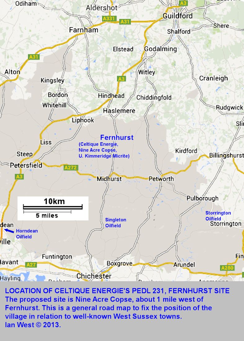
Celtique Energie intend to drill into the Kimmeridge Clay Formation at Fernhurst in Sussex. They have provided much useful information in a brochure, and have given a public presentation. From their publications the scheme would seem to be broadly similar to that planned by Cuadrilla for Balcombe. There is the Kimmeridge oil shale, with bituminous, argillaceous limestone above at a rather similar depth. Fernhurst is in part of the same western Weald Basin as is Balcombe.
LOCATION
8.1 WISBOROUGH GREEN AND KIRDFORD (SITE REJECTED)
Kimmeridge Clay and Great Oolite
An announcement was made on the 28th July 2014 that Wisborough Green no longer had permission for a "fracking" borehole to take place. The objection was primarily with regard to the roads of the village being unsuitable for truck traffic. This is probably true; note, however, that the formerly proposed site is much closer to an "A Road", than is the Balcombe site, for example (about 5km away from an A Road). I do not know whether it is simplistic to assume that now a new, alternative Wisborough Green site next to the A272 will emerge sooner or later. A rather similar problem to that at Wisborough exists at Fernhurst where the present proposed site is hidden in woodland down minor roads and not next to the main A286. In the longterm perhaps the "Wytch Farm System" will be used with one large site in a region, about 20 horizontal boreholes extending for 10km or more into the region around. The Wytch Farm Oilfield has been in operation very successfully (although initially on a smaller scale) for about 40 years. Has the Wisborough Green decision now sent the Weald area in the direction of a few major borehole centres? Each of these could have major operations long into the future (decades), continuing major truck traffic, and long horizontal boreholes extending out under the villages? Wisborough Green (Kirdford) is, for example, within reach of a horizontal borehole from Broadford Bridge Fernhurst, theoretically, can be reached by a horizontal borehole from the A286 near Midhurst, although this probably not likely to happen. (The above is not a criticism, just a discussion point).
.
See BBC webpage:
Oil and gas drill site turned down in West Sussex
The test drilling site The proposal was for test drilling between Kirdford and Wisborough Green. An application for exploratory oil and gas drilling in West Sussex has been turned down. The company behind the application, Celtique Energie, wanted to drill on land between Wisborough Green and Kirdford. However, West Sussex County Council's planning committee unanimously voted to refuse the application.
Planners said the villages' roads would not be able to cope with the extra traffic from lorries at the site. Heidi Brunsdon, chairwoman of the committee, said: "There were simply too many highways issues and other issues of concern for any decision other than refusal in this instance. We have noted the objections of the local community and I felt that the debate today was a full and robust one.Andrew Jackson, from Wisborough Green parish council, said: "A benchmark needs to be set for the whole region. If this was to be allowed today, it sets a benchmark for all other villages like ourselves. It's clear that earlier applications that have been approved have all had direct access to the major lorry routes. This one does not and it is not an appropriate location."
.


.
[Previous notes follow:]
At Wisborough Green an application was made for only for an exploration borehole. This will determine the characteristics and prospects of the strata beneath, including the Kimmeridge Limestone or Kimmeridge Micrite.
"Celtique Energie" (Celtique Energie Weald Ltd., the oil and gas exploration company with its joint investment partner Magellan Petroleum (UK) Ltd.) has applied to set up a temporary well site near the villages of Kirdford and Wisborough Green, Sussex. The proposal is to use a screened area of land.
The test is for the presence of commercial oil or gas in the:
Kimmeridge Limestone (the "Kimmeridge Micrite") and in
the Middle Jurassic Great Oolite (at greater depth). The latter is a commercially valuable reservoir rock at various localities in the region, and to the west. It is a conventional oil reservoir at Storrington and elsewhere. However, improvement of the reservoir porosity and permeability by hydraulic fracturing is a possibility, since this seems to be being applied elsewhere in the Sussex, Hampshire, Wiltshire area.
LOCATION
8.2 MARKWELLS WOOD No.1,
Location of wellsite:
Location: West Sussex, near the Hampshire Boundary. Map reference SU758133. Six kilometres east of Horndean (and about 4km ENE of the Horndean Oilfield). North of Emsworth. Nearest village West Mardens. In the southeastern part of Markwells Wood, near Forestside and Northwood Farm.
Summary Data:
Well completed: December 2010 or early January 2011.
Reservoir: Great Oolite - vertical thickness 44.5 m (thinner than expected - 73m.)
Reservoir porosity: 12 to 13 percent, normal for Great Oolite in this region.
.


More Summarised Information:
[Notes, partly general and partly from:
Energy Pedia News - Northern Petroleum confirms oil in Markwells Wood 1. With additional comments based on: P. McDowell, in: Hampshire Rambler, July 2014.]
1. Well is in licence PEDL 126, West Sussex.
2. The Licence Partners in the Markwells Wood-1 well are: Northern Petroleum (GB) (operator) 50%; Magellan Petroleum (UK) 40%; Egdon Resources U.K. 10%.
3. Location: About half a kilometre north of Forestside.
4. Map Reference: SU 758133. North of the road between Rowland's Castle and West Marden (closer to West Marden). It is not as close to the A3(M) major road, as Horndean and Rowland's Castle wells, and perhaps less suited to major vehicle activity, should that be ever needed.
5. Access. There is no access from the road, but a public footpath from West Marden passes just north of it. It is not conspicuous unless a drilling rig is present.
6. Oil bearing. Oil-water contact in the Great Oolite at 4446 feet (1355 metres) sub sea-level.
7. Gross hydrocarbon-bearing interval - 275 feet with calculated net reservoir of 192 feet, with porosity 13 to 14%.
8. Similar to the conventional wells of Horndean and Roland's Castle, about 4 km. east.
9. The well was very deviated - 56 degrees (off the vertical?), but not horizontal.
10. Wells of this type in the Great Oolite reservoir of western Sussex and eastern Hampshire could in theory now be much improved by horizontal drilling and hydraulic fracturing (i.e. "fracking") and/or acidizing (with hydrochloric acid). Note that this is not "shale-fracking" because it is a means of improving the porosity and permeability of limestone, known to contain oil, and not shale. There seems to be no suggestion that hydraulic fracturing will happen here in the near future, if at all.
.
Great Oolite Reservoir
This seems to be a small to medium oilfield in the Great Oolite Reservoir and in some respects rather like Singleton, but at an early stage of development. There has been several articles in the press regarding this in January 2011, at a time when the first borehole has been completed and the drilling rig removed. The notes below come mainly from press reports. The depth to the oil-water contact is similar and the reservoir, the Great Oolite, is the same. The first well has been drilled by Northern Petroleum. Live oil has been found in a cored portion of the reservoir. Apparently the mean potential is between 35 million barrels of oil in place and 61 million barrels of oil in place (compare to Singleton with 70 million barrels of oil in place). However full information is not yet available and a programme of testing for production is to take place.
The well is interesting from more than one aspect. It is a very deviated well, at 56 degrees according to Stockopedia. This means the location at which the oil reservoir was drilled into is not under the well site at Markwells Wood and may be about about a kilometre or a mile away. A future production well-site may be at the same place, but it does not have to be now that horizontal drilling is common (Wytch Farm, Dorset, oilwells have been producing for years from locations 11 kilometres away from the drill site).
Because the well was very oblique to the reservoir the thickness recorded in the borehole is much greater than the true vertical thickness. The gross hydrocarbon-bearing interval intersected in this sloping borehole was 83.8 metres (275 ft). However the calculated true thickness is only 44.5 m (146 ft), compared to an expected estimate of 73 m (240 ft). The original estimate would have been compatible with Horndean Oilfield, not far away. See also the isopach map of
Sellwood et al. (1985). It is not clear as to why the Great Oolite is apparently thinner in the Markwells Wood borehole than in adjacent areas. This might be the result of local faulting, possibly the intersection of a fault by the borehole, or perhaps, less likely, the presence of a local penecontemporaneous high in Middle Jurassic times. No doubt more information will be available on this later.
Although the reservoir thickness is different, the porosity is of about the same as for other oilfields in the region in the same reservoir Stockopedia.
Environmental Aspects
Because this well is in the South Downs National Park, there are environmental issues. At present, as shown by photographs included here it is very inconspicuous, and at the present (January 2011) there is just a square area of concrete or tarmac with a single well-head in the centre, and one or two huts. There is no direct public access from the road. However, if you go to the nearby village of West Mardon and walk westward through the woods on the footpaths you can probably find it within about an hour. Unless there is a drilling rig on site, you will not see it until you are within about 100 or 200 yards.
Addendum, 2014 - See also
Markwells Wood Enquiries Online in 2014
Enquiries about oil and gas exploration at Markwells wood, West Sussex.
Questions are asked on this website (which should be visited).
"Dear Environment Agency,
I would be grateful if you could answer the following questions
about the oil and gas exploration site in Markwells wood, West
Sussex (most recent planning application SDNP/13/01347/CND). I
refer to Northern Petroleum/iGAS as 'the developers' during this
request.
1. What permits are currently held by the developers for this site?
2. Please provide a list of all chemicals that will be used (or may
be used if felt necessary) during testing, drilling or fracturing
if applicable.
............ further questions ........
[This continues regarding waste, methane, NORM etc. - Go to the website.
The relevance of this is that the questions are good and quite thorough.
It is not easy to see from the webpage as whether they have been answered.]
Markwells Wood Reference:
.
Stockopedia. 2011. Northern Petroleum and Egdon Resources boosted by Markwells Wood oil success. www.stockopedia.co.uk/content/northern petroleum and egdon....
[note this is old reference, find 2016 data about horizontal drilling.]
Online at:
Stockopedia - Northern Petroleum and Egdon Resources boosted by Markwells Wood oil success.
"The presence of live oil was observed when the 30 feet of core was extracted from the well. Initial analysis of the logs indicates the well, which was deviated at an an inclination of approximately 56 degrees through the Great Oolite penetrated a gross hydrocarbon bearing interval of 275 feet with a calculated net reservoir of 192 feet with an average porosity of 13 - 14 percent, a typical porosity value for this reservoir in the nearby fields in the same formation. The top of the Great Oolite was encountered 51 feet low to prognosis and the Great Oolite vertical thickness was 146 feet compared to a prognosis of 240 feet."
[Notes: Drilling logs had confirmed that the entire Great Oolite drilled reservoir sequence in the well is oil-bearing. Nine metres (30ft) of core was extracted. The gross hydrocarbon-bearing interval in the well was 83.8 metres (275 ft) but the well was deviated at approximately 56 degrees. Net reservoir was 58 m (192 ft), but remember that this is in the very deviated well. Of broader significance it should be noted that the vertical thickness of the Great Oolite was found to be 44.5 m (146 ft), compared to a prognosis of 73 m (240 ft). This is low for the area. See the Great Oolite isopach map in
Sellwood et al., 1985. The average porosity was found to be 12 to 13 percent which is typical for this reservoir in the nearby fields in the same formation. Expected production rates will be determined in a future test programme.]
.
.
UKOG. UK Oil and Gas Investments PLC. 2016. Markwells Wood. Licence No. PEDL126. UKOG interest 100%.
Go to website:
Markwells Wood.
"The Markwells Wood-1 discovery well was drilled in 2010. It is operated by UKOG's fully-owned subsidiary UKOG (GB) Limited. The discovery is a conventional Jurassic Great Oolite limestone reservoir, the same as in the Horndean producing oil field (UKOG 10%), which is located 3 km to the west. The well was tested over a 6-month period in 2011-12, producing 3,931 bbl of oil. UKOG has applied to extend the Markwells Wood planning permission to 30 September 2016. Approval is expected shortly." [continues - go to UKOG webpage]
[This brief but informative webpage includes a colour map of the top Cornbrash, showing the structure, the traps and the faults. The production estimates and the intended locations of development wells are shown. The webpage is very open and informative. It is has similarity to the nearby Horndean field, except for the suggested horizontal wells at Markwells Wood.]
LOCATION
8.2a - MARKWELLS WOOD CONTINUED - DIAGENESIS, POROSITY, PERMEABILITY ETC.
.
The Great Oolite Diagenesis and Burial History in General.
See particularly, this summary and the full paper (if you have access to it)
.
The paper below relates to the Storrington Borehole into the Great Oolite but can be applied to the proposed Markwells Wood Borehole.
McLimans, R.K. and Videtich, P.E. 1989. Diagenesis and Burial History of Great Oolite Limestone, Southern England. AAPG, American Association of Petroleum Geologists, vol. 73, Issue 10 (October), pp. 1195-1205, ten pages. By Roger K. McLimans and Patricia Videtech. [An open, pay for view, PDF can be purchased for 24 dollars. The full text is available to Members of the AAPG].
Abstract: Oil is produced from the Middle Jurassic Great Oolite Limestone in he western Weald basin, England. Additional production was discovered (150 STBOPD [BOPD - barrels of oil per day], 42 API [American Petroleum Institute gravity, - Light Oil > 31.1 ] at the Conoco No.1 Well at Storrington, Sussex. The Storrington discovery is of note because the porosity in reservoir grainstones and packstones is largely primary and averages 19.4 percent, the highest value yet found for the Great Oolite. Secondary porosity is of little signficance. For all the wells studied, porosity in Great Oolite grainstones and packstones ranges between 3 and 20 percent, and there is no relationship between porosity and lithology. Locally, porosity may be largely occluded by coarse calcite spar, which fluid inclusion studies show precipitated in the deep burial environment. Exploration in the Great Oolite, therefore must seek diagenetic fairways where primary porosity has been preserved.
Limestones in the producing interval of the Great Oolite at 1 Storrington contain zoned syntaxial cements, are generally high in magnesium content, and have stable isotope composition that indicate the involvement of marine waters (relatively heavy oxygen 18 isotope). Our interpretation is that the limestones were stabilized early in a mixing zone between freshwater and marine phreatic environments.
Coarse calcite spar in the Great Oolite contains aqueous and oil inclusions. The results of geothermometry studies show that the precipitation of calcite cements occurred at depth, near maximum burial and, at certain locations, was synchronous with oil migration. Inversion of the basin was a later event. The construction of burial history diagrams that incorporate fluid inclusion and maturation data shows that oil migration was during the Late Cretaceous. A distribution pattern for oil inclusions in the Great Oolite indicates migration was mainly in the western part of the basin and initially into pre-Late Cretaceous traps.
.

[Note that the diagram is subject both to general editing and to minor changes in relation to recent work. Please regard the present version as preliminary and explanations will be given in due course about modifications. Mixing-zone dolomite, has, for example, been the subject of later investigations. The diagram has been simplified and redrawn in colour and it now serves its purpose as a useful starting point for further discussion. [further material is to be addded].
Some more aspects of the Great Oolite are discussed here. For a summary see:
Great Oolite Group; BGS Lexicon of Named Rock Units. The Inferior Oolite Group is beneath. The Kellaways Formation is above. It is up to 100 to 200 metres thick in the Weald Subcrop, with which this particular webpage is concerned.
The diagram, above, has been completely redrawn in colour with modifications. Although it is primarly concerned with dolomite and dedolomitisation it also provides information on the general diagenetic history of the Great Oolite. It is based on: Sellwood, B.W., Scott, J., James, B., Evans, R. and Marshall, J. 1987. Regional significance of "dedolomitization" [or dedolomitisation] in Great Oolite reservoir facies of Southern England. For more information go to:
Sellwood et al., (1987) and who made, detailed studies. See the original paper. Much of this early work was on the Humbly Grove Oilfield, one of the first areas in which the oil and gas target rock was the Middle Jurassic, Great Oolite Group.
.
.
LOCATION
8.3 STORRINGTON (Sussex)
IGAS - Island Gas Ltd. Site.
Estimates of reserves from a Celtique Energie publication:
OOIP 11mmbbl = Original Oil in Place - 11 million barrels
(1 bbl = 42 US Gallons or 159 litres approx.)
GIP 11 bcf - Gas in place - 11 billion cubic feet.


The site shown above is Storrington Oilwell Site, Pulborough Road, Cootham, Storrington RH20 4HP. It is at present a small oil field.
The company owning this field in 2014 is Island Gas Company - Igas.
[See:
Macalister report regarding IGas exploration for shale gas in Surrey and Sussex.
"He said that IGas had for many years been quietly operating 100 onshore oil wells around the UK, including in Surrey and Sussex, where there could be potential for shale extraction" [i.e in the Central Weald where the Lias, Oxford Clay and Kimmeridge Clay are thermally mature, as at Balcombe].
The site is located on the eastern side of the A283 north of Storrington, in Horsham District, with the road separating the site from South Downs National Park. It was the subject of a retrospective planning applications (a copy is available online as a pdf):
"This report relates to an application by IGAS for planning permission to allow the continuation of hydrocarbon (oil) production at their site near Storrington for a further five years. No physical works are proposed. The application is retrospective as the company has continued to operate at the site since the expiry of its previous application (SR/68/96) in December 2012." ...
"Conclusion: It is not considered that the proposed continuation of the use of the site for oil production for a further five years would result in any significant impacts on people, the environment or the highway network, and no objections to the proposal have been received from either consultees or the public. The site is well screened from view, and results in few off-site impacts in terms of noise or other emissions. The site is located on the A283, allowing good access to the highway network for the limited number of tankers accessing the site."
Further notes:
At present, 80 barrels of oil per day is produced at the site. This results in up to two tankers of oil being taken from the site each week.
The site contains a sealed, impermeable platform containing three wells with 'nodding donkeys' and one well for the re-injection of water. There is a five metre high flare.
The Storrington field was discovered in March 1986 and its reservoir is the Great Oolite (DECC, 2010). It lies on the southern margin of the Weald Basin in West Sussex, on the trend of the nearby Horndean and Singleton oilfields. The trap is located on an E-W trending horst with closure to the east and West (Trueman, 2003).
.
For more information on the Storrington Well, see:
Andrews, I.J. 2014. Appendices to the Jurassic Shales of the Weald basin: Geology and Shale Oil and Shale Gas Resource Estimation: BGS, DECC. In particular, within this, see: Appendix D: Gent, C.M.A., Hannis, S.D. and Andrews, I.J. 2014. Appendix D. Estimation of total organic carbon in the Jurassic shales of the Weald area by log analysis. 76 pp. Go to Figure 16, Storrington 1 TOO1SE/27.
The report referred to above, gives a part of the Storrington 1 well, from depth 2199.9 ft to 6499.98 ft. It does not give the whole well record. The Kimmeridge Clay thickness is 1289.8 ft (393 m.). This is quite thick, in fact it is thicker than the basinal, type-section sequence at Kimmeridge, where it is 508 m. (Cox and Gallois (1981)). A thick sequence is more favourable for relatively thick oil shale and improves the chances of good thermal maturity. So these are favourable factors.
The Kimmeridge Clay has a fairly good calculated TOC in the middle part of the sequence, at round about 2,900 feet. The TOC figure is the Total Organic Carbon, a measure of potential oil and gas source content. A high TOC means a content of oil shales. There is almost 250 feet of good oil shale. Particularly notable is that the base of the Oxford Clay has an even higher TOC of about 10%. The organic-rich interval is of about 100 ft thick, although in part the calculated TOC is down to about 4%. The Middle and Upper Lias is not very promising, with a calculated TOC of about 2% (although over a thickness of about 650 ft.)
Now Storrington is just south of the area of good thermal maturity as estimated by BGS. Broadford Bridge site is about 7 km away to the northeast. That is within the zone of thermal maturity of Jurassic shales. If there is similarity between Broadford Bridge and Storrington in terms of distribution of organic-rich shales, then parts of the Oxford Clay and the Kimmeridge Clay might be suitable for hydraulic fracturing there. Depending upon what happens at Broadford Bridge, and if part of the sequence is sufficiently thermally mature, then it is just possible that hydraulic fracturing could take place at the latter at some time in the future. The site is away from buildings. It is not wooded but it probably could be concealed by trees, should that ever by necessary. At the moment there is no reason to believe that anything special may happen.
.
The following paper is very relevant to the Storrington Borehole into the Great Oolite Petroleum Reservoir. The reservoir rock retains much primary porosity here, but this is not true everywhere. See the following paper.
McLimans, R.K. and Videtich, P.E. 1989. Diagenesis and Burial History of Great Oolite Limestone, Southern England. AAPG, American Association of Petroleum Geologists, vol. 73, Issue 10 (October), pp. 1195-1205, ten pages. By Roger K. McLimans and Patricia Videtich. [An open, pay for view, PDF can be purchased for 24 dollars. The full text is available to Members of the AAPG].
Abstract: Oil is produced from the Middle Jurassic Great Oolite Limestone in he western Weald basin, England. Additional production was discovered (150 STBOPD [BOPD - barrels of oil per day], 42 API [American Petroleum Institute gravity, - Light Oil > 31.1 ] at the Conoco No.1 Well at Storrington, Sussex. The Storrington discovery is of note because the porosity in reservoir grainstones and packstones is largely primary and averages 19.4 percent, the highest value yet found for the Great Oolite. Secondary porosity is of little signficance. For all the wells studied, porosity in Great Oolite grainstones and packstones ranges between 3 and 20 percent, and there is no relationship between porosity and lithology. Locally, porosity may be largely occluded by coarse calcite spar, which fluid inclusion studies show precipitated in the deep burial environment. Exploration in the Great Oolite, therefore must seek diagenetic fairways where primary porosity has been preserved.
Limestones in the producing interval of the Great Oolite at 1 Storrington contain zoned syntaxial cements, are generally high in magnesium content, and have stable isotope composition that indicate the involvement of marine waters (relatively heavy oxygen 18 isotope). Our interpretation is that the limestones were stabilized early in a mixing zone between freshwater and marine phreatic environments.
Coarse calcite spar in the Great Oolite contains aqueous and oil inclusions. The results of geothermometry studies show that the precipitation of calcite cements occurred at depth, near maximum burial and, at certain locations, was synchronous with oil migration. Inversion of the basin was a later event. The construction of burial history diagrams that incorporate fluid inclusion and maturation data shows that oil migration was during the Late Cretaceous. A distribution pattern for oil inclusions in the Great Oolite indicates migration was mainly in the western part of the basin and initially into pre-Late Cretaceous traps.
LOCATION
9.1 BROADFORD BRIDGE, SUSSEX
There is information available online about the Woodbarn Farm site, near Broadford Bridge, in West Sussex. This is almost between Wisborough Green and the Storrington oil field. It may be a conventional well to be targeted on the Triassic (the Triassic Sherwood Sandstone is the lower and main reservoir of the Wytch Farm oilfield, Dorset and as a conventional oilfield holds the greatest oil and gas reserves in southern England).
For more detailed information, see the Website of Celtique Energie on the Broadford Bridge project. This is available online as a pdf file.
Extract from the beginning:
"Celtique Energie Exploring responsibly for oil and gas in Europe
This region of Sussex is covered by Celtique’s exploration licence PEDL 234 which provides the company with exploratory drilling rights, subject to planning approval. Celtique has 20 exploration licences in six untries
within onshore Europe and is the operator of 13 of
these licences. The company is led by a highly experienced team who
have worked in energy exploration and production for many years and employs 30 dedicated members of staff and specialist consultants.
In 2008 the Department of Energy and Climate Change
(DECC) awarded Celtique four licences to explore for oil
and gas in southern England along with its partner
Magellan Petroleum (UK), a separate company that holds
a 50% interest. Petroleum Exploration and Development Licences
(PEDLs) 231, 234 and 243 are located in the central Weald
Basin and these form the core area of the company’s
exploration effort in this region. Geological and geophysical studies indicate that there could be significant untapped reserves of oil and gas in this region. ... {continues]
Celtique Energie Exploring responsibly for oil and gas in Europe
This region of Sussex is covered by Celtique’s exploration licence PEDL 234 which provides the company with exploratory drilling rights, subject to planning approval. Celtique has identified a structure beneath the surface at Woodbarn Farm, near the village of Broadford Bridge that
may contain a large oil or gas accumulation and are keen
to investigate it by drilling an exploration well. Celtique is submitting a planning application to West Sussex County Council (WSCC) to construct a temporary well site and drill an exploration well. The proposed site at Woodbarn Farm is about one mile west of Broadford Bridge. The well
would be drilled to a depth of approximately 3km (10,000 feet) below ground level. Celtique has undertaken an Environmental Impact
Assessment (EIA) to better understand the site and its surroundings, and will take all steps needed to ensure the protection of wildlife and the
natural environment.
[continues - go to this website pdf]
LOCATION
9-2 MIDHURST, SUSSEX
(Important town in oil-producing region, but without oil wells)


Midhurst is not, at present, a locality for oil wells. However, it almost exactly half way between the Singleton Oilfield (Middle Jurassic, conventional) in the south and Fernhurst (planned for shale oil-gas exploration) in the north. Singleton is already successful, and Fernhurst proves to be good for shale hydrocarbons, then more wells, closer to Midhurst are quite likely, sooner or later. The Rogate No. 1 well is about 15km to the west. It is out of the thermally mature zone, but it means that there is, or will be, good subsurface data around the Midhurst area.
In addition, Midhurst is an important place in West Sussex, because the South Downs National Park Authority has its offices at the South Downs Centre here. Planning decisions regarding oil and gas exploration may be made here.
Geologically, Midhurst is on Lower Greensand, which occupies a substantial area of the western Weald.
LOCATIONS -
9.3 PALMERS WOOD, GODSTONE, SURREY, RH 9
"Star Energy, owns three wells at its Palmers Wood oilfield, which passes under land owned by Mohamed Al Fayed in Oxted, Surrey. Production began in 1990 and by the end of 2007 the company had extracted oil worth 10 million pounds." (Newspaper report, November 2010).
"The above ground hydrocarbon development at Palmers Wood Oilfield is made up of two wellsites, Rooks Nest and Coney Hill linked by an underground pipeline. Oil is produced at both wellsites but is gathered and exported from Rooks Nest the site closest to the A22 which links to
the M25 motorway. Palmers Wood Oilfield has been developed over the past 28 years and has been in production for 21 years." (Extract from Minerals and Waste Application: TA11/1484, 12 Dec. 2012. Star Energy Weald Basin Ltd.)
The Palmers Wood Oilfield, can be seen next to the motorway, on Google Earth. There is one "nodding donkey", beam pump in the centre, and much piping.
.
Sun, S.Q. and Wright, P.V. 1998. Controls on Reservoir Quality of an Upper Jurassic Reef Mound in the Palmers Wood Field Area, Weald Basin, Southern England. By S. Qing Sun and V. Paul Wright. AAPG Bulletin, V. 82 (1998), No. 3 (March 1998), P. 497-515.
Abstract:
An Upper Jurassic (Oxfordian) reef mound in the Palmers Wood field area of the Weald basin, southern England, clearly shows the relationship of facies, diagenesis, and porosity development to relative sea level changes. The coral-microbial reef mound was initiated over a drowned oolite shoal during a third-order marine transgression and exhibits changes in coral morphology from base to top as the reef mound caught up with sea level during the subsequent highstand. During the highstand, extensive encrustation of the reef mound took place by microbial, stromatolitic cements, with subsequent porosity loss. During the following lowstand of relative sea level, extensive leaching of the aragonitic corals took place, and a lowstand wedge accumulated down-ramp. Porosity was lost during burial-related cementation and compaction. Coral-microbial reef mounds of this type have moderate potential for porosity formation, unlike tighter, deeper ramp reefs in the Jurassic, which are less prone to subaerial leaching and have less potential for secondary porosity development because they are less rich in aragonitic components. Although the Upper Jurassic reef mound is only a minor contributor to reservoirs in the Palmers Wood field, it may provide a model for other Upper Jurassic reef plays.
See also:
Andrews, I.J. et al. (2014) The Jurassic Shales of the Weald Basin: Geology and Shale Oil and Shale Gas Resource Estimation. 79 pp. BGS and DECC. With Appendices
Appendix E. p. 2. (table)
Palmers Wood 1.
Elevation: 459 ft. above MSL.
Top Kimmeridge Clay 1696 ft below MSL
(Top Corallian 2590)
(also data for Top Oxford Clay, Top Upper Lias Clay and Top Mid Lias Clay.)
LOCATIONS -
9.3a LIDSEY OILFIELD, WEST SUSSEX
.

.

.

.
Lidsey is a small village, north of Bognor. It is shown on Google Earth and on the Ordnance Survey map, Chichester and the South Downs, 1:50,000 scale map. From Bognor head north on A29 main road to Westergate. Go a couple of kilometres, past Shripney and at Lidsey, a small village, turn right (east) up a track or lane to where the map marks "works". On Google Earth you will see a conspicuous holiday camp of caravans at Lidsey. Turn right just at the northern end of these and head for the "works". There is a track adjacent to an old canal and the well site is just to the north of the track (there are other work to the south). The grid reference is SU 944650339.
Oil was discovered by Carless Exploration in a well at Lidsey in 1987. There is one vertical producing well in Great Oolite Reservoir. The Majority Partner is Angus Energy Plc. The licence is PL241. Angus has a 50 percent licence interest. The licence area is 5.3 km.
"A new Lidsey-2 Well will be drilled up-dip to target optimal flow conditions", according to an Angus Investor Presentation in July 2016.
.
Go to:
Angus Energy - Lidsey Oil Field.
.
Doriemus PLC has a participating interest in the Lidsey Oilfield of 20 percent. They reported that the Lidsey Field contains 9.2 mmbbls (gross) of P50 or best case Oil-in-Place (see the Doriemus website - www.doriemus.co.uk/lidsey-oil-field). The Lidsey surface facilities have an onsite oil storage of 2,000 barrels.
The locality is very interesting because the oil-bearing sequence deep beneath the Intra-Cretaceous Unconformity. The reservoir is the Middle Jurassic, Great Oolite Group with a top round about 3250 feet [990m.] and a base near 3450 [1052m.]. The thickness of the Great Oolite limestone in Lidsey 1 is 183 feet or 55.7 metres. The site is southeast of Singleton Oilfield (in the Great Oolite reservoir) and southwest of Storrington Oilfield (also in the Great Oolite Reservoir.
These figure are very similar to those at Markwells Wood and Horndean and fairly usual for this area of West Sussex. The structure (like that at Markwells Wood) is a north-dipping half dome, closed to the south by Intra-Cretaceous (Late-Cimmerian or Biscayan) fault. The interesting aspect is that this is a continuation of the same line of faults but is a parallel fault structure to the south. The village of Lidsey is almost exactly over the culmination of the structure with the well-site and pumps a short distance to the east.
[There is no obvious reason why this interesting structure should have any significant effect on the village of Lidsey. It has been worked for a long time without any trouble, and the oil well site seem to be particularly well-hidden and probably hardly noticed. Notes and diagrams here are only provided for educational purposes. They show nothing that is not already publicly known. This is just another Late Cimmerian, extensional type, oilfield of the Western Weald, with structural development in the Early Cretaceous and probably oil migration in early to mid Cretaceous times. There many others like it and they all have an interesting geological history (of Inversion Structure type).]
[Lidsey Oilfield Update Note online: 9th December 2013. Old and may be out-of-date now. Published and available online from Doriemus PLC. In Trustnet.com Investments.
"Doriemus Plc announces that the operator of the Lidsey-1 well, Angus Energy logged a total of 28ft. of virgin unperforated Great Oolite reservoir from 3,320ft down hole MD(measured depth) to 3,348ft M.D. The top 15 feet of the Great Oolite Formation was perforated yesterday from 3,200 ft. MD. down to 3,335 ft. MD.
In order to maximise flow rates from Lidsey-1 well, a more detailed logging programme will be undertaken to determine the exact location of the current producing interval, the oil water contact point and the potentially to isolate this water. A further perforation programme may be undertaken in the coming days on the additional virgin zones prior to putting the well back into production. The well is being re-completed for anticipated increased production levels with updated downhole equipment."
[The Lidsey Oilfield is owned by Angus Energy Weald Basin No.e 3 Limited (80 percent interest and Operator) and Doriemus (20 percent interest) and is held under UK Production Licence PL241. Lidsey has one vertical producing well (Lidsey-1) in the Jurassic, Great Oolite reservoir producing 38 API oil. The Lidsey surface facilities are fully permitted and operational with onsite oil storage of 2,000 barrels. All production is currently sold to the Perenco BP refinery.]
LOCATIONS -
9.3b MIDDLETON BOREHOLE, WEST SUSSEX
.
An exploratory borehole for oil was drilled at Middleton, West Sussex, in 1971. It was unsuccessful and plugged and abandoned. Detailed information has not been found. The place is notable geologically for the Portsdown - Middleton Fault, a boundary fault of the Weald Basin.
LOCATIONS -
9.4 SINGLETON OILFIELD, WEST SUSSEX
(also mentioned similarly in the Oil-South-of-England.htm webpage.)

.

Summary Data
(mostly after Trueman (2003))
Location: Near village of Singleton, West Sussex, north of Chichester. Installation is in a forest north of Singleton.
Discovered: 1989 by Regneneses Group.
Structure: E-W elongated, faulted horst. Effectively a continuation of the Horndean Trend.
Depth to crest: 1234 metres (4050ft.) for northern, 1271 metres (4170 ft.) for southern.
Reservoir: Great Oolite, Forest Marble and Cornbrash. Great Oolite (Bathonian) is a series of prograding oolite shoals deposited on a broad carbonate ramp.
Production Licence PL 240.
Porosity and permeability is low. Porosity average: 13%; permeability average: 0.5mD (milliDarcies). Porosity is high below the Hoddington Member (i.e. Humbly Grove and Hesters Copse Members)
STOIIP - Stock Tank Oil Initially in Place. (Great Oolite Reservoir) estimate: 70 MMSTB (70 million stock tank barrels in place - not all recoverable). (Compare with STOIIP for Stockbridge, the large field, - 171 MMSTB).
Production: Was 450 barrels of oil per day, now about 600.
Cumulative production to 2003: 2.85 MMSTB, million barrels of stock tank oil (i.e. 2.85 million barrels of oil). Gas content uncertain.
Oil density: 39.15 degrees API.
Formation water - brine about half full halite saturation level - 150 parts per thousand (seawater is about 35 ppt).
.
General Notes on the Singleton Oil Field and the Environment
:
The Singleton Oilfield (map ref. SU 884154) is inconspicuously situated in Singleton Forest about 10km. north of Chichester, Sussex. It is within the picturesque Chalk hills and forests of the South Downs. It is near the A286, the Midhurst road, north of Chichester, and about 2km. north of the village of Singleton. You cannot drive to the well site but it is not far from a public footpath in the woods. The site is fairly small, well-fenced and guarded and effectively hidden in the woods. Little can be seen from the outside.
The beam pumps are painted a dull, vegetation colour. There is control over noise to a limit of 33 decibels; the trees help reduce noise, particularly when they are in leaf. It is, thus, relatively inoccuous from an environmental point of view and has hardly any visual impact.
The oilfield is one of several in the West Weald, that is the West Sussex and East Hampshire region. It is within onshore licence PL 240 and is largely owned by Providence and it is operated by Star Energy Group PLC (STAR). The field has been producing since 1986. Estimates of STOIIP [oil in place] in the Great Oolite reservoir are approximately 70 MMSTB [million barrels]. It is trucked to the Holybourne Rail terminal for sale (Providence Oil Company, October, 2007 - Singleton Oil Field Acquisition Effective).
The site, has at present six wells, including five beam pumps or pumpjacks (nodding donkeys) and a jet pump well. A few years ago the site was producing about 450 barrels of oil per day Anonymous (2008), but the figure is now higher and at about 600 BOPD (Providence Oil Company). Planned expansion will increase production to between 850 to 1,000 barrels per day. Providence Energy will be increasing the one-hectare site by 0.3 hectares and installing four new jet pumps. Singleton Oilfield has been in operation since 1990 and has expanded several times over the past 18 years. It has planning permission to drill for oil until 2016. For more information on ownership see Providence (2007).
It should be noted that Star Energy Group PLC (STAR) are also involved with Providence in Natural Gas production at the Singleton Oilfield.
The main reservoir rock at Singleton, as in adjacent areas of the Western Weald (Sussex-Hampshire border) is the Great Oolite, although the limestones of the Forest Marble and Cornbrash above are also in use.
The field consists of two east west trending elongate horst blocks divided by a narrow graben (Providence Oil Company, October, 2007 - Singleton Oil Field Acquisition Effective). The wells
produce from the Great Oolite formation, consisting predominantly of oolitic lime grainstones deposited during transgressive/regressive episodes and has been sub-divided into three members. Note that there can on occasions be some problems with terminology, in that the Great Oolite Limestone Formation was considered by Sellwood et al. (1985) to be part of a larger Great Oolite Group which also includes the Forest Marble. It seems here that from the reference to three members, the scheme of Sellwood et al is being used, and that the members are the Humbly Grove Member (at the base), the Hoddington Member and Herriard Member. The Forest Marble lies above the Herriard Member, and consists, in the region, of skeletal oolitic packstones and grainstones with interbedded claystones (mudstones). It tends to be more skeletal than the Great Oolite Formation beneath, and has a typical Forest Marble fauna, including crinoidal debris.
An isopach (thickness) map of the Great Oolite Limestone Formation (i.e. Great Oolite sensu stricto) has been provided by Sellwood et al. (1985). He gave the Great Oolite Limestone Formation as between 60 and 75m. thick in the area of Singleton and Horndean. The Singleton X-9 well was drilled in this main Great Oolite reservoir in the southwest flank of the field. However the Singleton X-8x well is situated on the northern flank of the field and a 2,000 foot (609m.) horizontal section was drilled and completed in the Cornbrash and Forest Marble sequences. Wells in the area have similar oil water contacts within the Great Oolite
reservoir, indicating that the prospects may be connected Providence (October, 2007) have provided a map of the oilfield showing that the wells are greatly deviated to the south, the southwest and to the southeast for two or three kilometres. Some of these pass close to the village of Singleton, which is south of the well site. The map suggests that the location for the facilities could have been at the village, or on open fields south of its present site, but an environmentally concealed place in woodland was chosen.
In the long term future the oilfield could be used for gas storage (Providence, October, 2007). This means that it is not a temporary operation but it likely to be an almost permanent feature, at least in some form.
[Additional note from online information. Conventional acid stimulation has apparently been used here. 2014]
Singleton Pollution Incident, 1990s
Regarding a pollution incident at the well cellar at Singleton Oil Field in the 1990s, see:
Davies, et al., 2014.
"The two pollution incidents at Singleton Oil Field (now operated by IGas but operated by a different company when the incidents occurred)
occurred in the early 1990s, and were caused by failure of cement behind the conductor and the 9 and 5/8th - inch casing. This was identified as a result of five groundwater monitoring boreholes installed at the Singleton Oil Field in 1993. The leak was from the well cellar (cement lined cavity in which the well head sits) via the pre-installed conductor and the 9 and 5/8th inch casing, both of which appear not to have been adequately cemented in situ in at least one well. A thorough investigation commenced in 1997, including the drilling of a number of (>11) additional boreholes, and the carrying out of tracer tests and CCTV examination under the auspices of, and in consultation with, the UK Environment Agency. The leak paths, once identified and verified, were remediated. Monitoring has continued since that time and the observed levels have remained below those set by the Environment Agency as requiring further action."
LOCATIONS -
9.5 HORNDEAN OILFIELD, WEST SUSSEX
.
Brief shortened notes after
Trueman, 2003 (on the Western Weald oilfields).
The Horndean Oilfield is situated in License PL211 in the vicinity of the town of Horndean, Hampshire. .. Data indicated the presence of pre-Cretaceous structural closure at Horndean. .. The field was discovered in early 1983 by the the Regnenses Group with the drilling of the the Horndean XI well (formerly Horndean 1a) . .. At Horndean an additional development well was drilled in 1990 (X2z) and was the first horizontalwell drilled in the Great Oolite in southern England. An additional sidetrack was completed in 1997 and a new well drilled in 1998. .. The reservoir is divisible into three main units, lower massive oolite, middle oncolite member and upper oolites. Structurally the field is typical of the southern flank of the Weald Basin, being an E-W elongate tilted fault block bounded to the south by a major, regionally recognisable south hading fault. The present spill point of the structure occurs across the south hading fault immediately to the south of Horndean XI and equates to a depth of around 4350 ft (1326 m.). [It is possible but not proven, because there are other more major faults in the area (Bembridge - St. Valerie), that this fault moved in 1834. It remains a question. See below]
In any case there may be an earthquakes occasionally in the Chichester area and this would apply to Markwells Wood etc in addition. See the following:
.
Memoirs of Sir William Knighton, Keeper of the Privy Purse.
Sir William Knighton,
Horndean,
28th August 1834
"I have had a violent attack of illness: but by keeping in my bed the whole of Wednesday, I am now, thank God, tolerable. On Wednesday night we were visited by a severe shock of an earthquake. Everyone in the house was alarmed and frightened, and all left their rooms more or less terrified. Independently of the houses and furniture shaking. It was accompanied with such a noise, that it was supposed something must have happened in the large drawing room. It was, I believe, still more forbidable at Emsworth, and was felt all round the neighbourhood. "Yours etc. "W.K."
[Note added in the book: The shock of the earthquake here alluded to was the most severe of several which about that time were experienced on the line of coast from Portsmouth to Chichester. It thus described in the public prints of the time. "On the morning of January 23rd, 1834, at twenty minutes before three o'clock [a.m.], the inhabitants of the city were suddenly aroused from their sleep by an extraordinary noise. At once their beds began to shake under them, the furniture in their rooms to move, and the bells in their houses to ring. All were alarmed and dismayed, numbers left their habitations and collected in the streets, where they understood the cause of their alarm." The terror, however, caused by this sudden earthquake remained upon their minds for a considerable time afterwards.]
LOCATIONS -
9.6 NORTH DENMEAD, WATERLOOVILLE, WEST SUSSEX
There was a three well programme in 1984 to appraise the Horndean and neighbouring North Denmead, Middle Jurassic accumulations. Denmead is a small village near Waterlooville. The North Denmead accumulation was not drilled, as it was considered too small, at least at that date, for commercial development. It is briefly mentioned in
Trueman, 2003 but I am not aware that it is of recent interest. It is probably of the same general pattern as Singleton, Horndean, Markwells Wood etc, which are oil traps in the Great Oolite on the north side of a major, east-west Intra-Cretaceous fault (of Late Cimmerian or Biscayan date). This fault is not seen at the surface or shown on the British Geological Survey maps because it is concealed beneath the Chalk and is at depths of a kilometre and a half or thereabouts. There are horizontal wells in the Great Oolite at Singleton and Horndean but not at North Denmead and not yet at Markwells Wood.
.
LOCATIONS -
10.1 STOCKBRIDGE OIL FIELD (NEAR WINCHESTER), HAMPSHIRE
.

The above map shows the location of the Stockbridge Oilfield in general terms and its relationship to the Weald Basin (now an Inversion Structure) which was the oil source area. The Stockbridge Oilfield is just one of a series of oilfields west and southwest of the Weald Basin, but it is the largest of these. There have been several separate wellsites, but Larkwhistle Farm site is the major one. It is west of South Crofton and the conspicuous water tower (seen from the main Winchester to Newbury road). Generally there is not much to see as the site is hidden in woodland, just off the Roman Road from Winchester to Andover (and not easily photographed). It can be seen on Google Earth. In spite of the name, the Stockbridge oilfield is east of Stockbridge and not actually at that location (although some initial exploration took place there). Rather surprisingly there is a Roman Road right through the main, key part, of the oilfield, and production has taken place alongside the Roman Road. The oilfield is also crossed by the A34 Winchester to Newbury main trunk road and many people from the south coast have driven over it at some time or another. Simplified maps of the Stockbridge Oilfield are now provided.
.

.

.

.

.
Amoco in the 1970s started planning oilwell drilling sites to the east of Stockbridge and north of Winchester. The initial planned sites were:
1. Leckford Well, Hampshire, Amoco. On the River Test, northeast of Stockbridge. This is only about 2 kilometres from the village of Stockbridge, and perhaps this proximity gave rise to the name Stockbridge Oilfield. It is not known at the moment whether this was drilled.
2. Chilbolton Down, Hampshire, Amoco. Further northeast and adjacent to the A30 road.
3. Hill Farm, Hampshire, Amoco. On the B3420, near the A30. Shown on the BGS mineral resources map of 2003.
4. Folly Farm, Hampshire, Amoco. On the A272. About one km. SW of Crawley Court.
5. Wallers Ash, Hampshire, Amoco. About two kilometres east of South Wonston. Shown on the BGS mineral resources map of 2003.
6. Hawks Grove, near Farley Down (Farley Mount). Details not known.
7. Leckford Estate, east of Leckford and near Chilbolton Down.
8. Furzedown, between Braishfield and Kings Somborne. Proposal: April 1987. Amoco (U.K.) Exploration Company and Ultramar Exploration Limited.
"Amoco (UK) Exploration Company and its equal partner, Ultramar Exploration Ltd., were awarded production licence PL233 by the Department of Energy on the 28 October 1983. The extent of the licence block and the location of the Furzedown Prospect are shown in Figure 1. Amoco are operators for the Group. Amoco and Ultramar also hold exploration and production licences in adjoining areas and have already carried out some drilling operations in these areas. Two boreholes were drilled at Hoe [the Hoe Lane Borehole, North Baddesley, near Romsey, described elsewhere in these webpages, but notable for a Jurassic bituminous shale succession, recently, in 2014, restudied by BGS] and Chilworth [northern part of Southampton] in 1982 and 1983 respectively. No hydrocarbons were found [presumably excluding bituminous shale]. A further borehole was drilled near Larkwhistle Farm, South Wonston [north of Winchester] in 1984 and oil was discovered. Further wells in the same area have been drilled and flow testing to appraise the extent and commercial viability is now in progress. The most recent drilling operation is at Goodworth Clatford where Amoco have recently drilled an exploration borehole."
[There is a promising horst here and the target area was between Parnholt Wood and New Wood, northwest of Fishponds Farm and Farley House.] [Notes from Amoco, 1987. Furzedown: Consultative Document Describing the Exploration Proposals, April 1987. 21 pages with diagrams showing faults etc. ]
Target rock horizons at: A at 900m below surface, B at 1100m below surface (Great Oolite?) and C, much deeper at 1800m (Sherwood Sandstone?).
9. Goodworth Prospect. In block PL232, Amoco/Ultramar.
10. LARKWHISTLE FARM, Hampshire. Oil discovery and main production site. This major site is on the B3420, one kilometre west of South Wonston. Amoco, Star Energy and now IGas. This one is active now. It is easily found by walking the footpath from South Wonston Water Tower, or by driving along the B3420. It is easily seen on Google Earth. Generally there is nothing special to see. A drilling rig is not normally present and there are only oil tanks and pumps, almost all hidden by trees and bushes and on private land. Chadwick and Kirby (1982) showed an east-west trending fault, downthrowing south, and located just south of Larkwhistle Farm. This is not shown on the new BGS Winchester Sheet 299, nor on the old 1896 edition. It is presumably in sub-Gault (i.e. pre-Late Cimmerian) strata.
With regard to its history, the following old document exists and is held in Southampton University Library (Cope Special Collection):
AMOCO (U.K.) Exploration Company, Ultramar Exploration Company. 1985. Larkwhistle Farm Oil Discovery: Consultative Document Describing the Appraisal Programme. May 1885. Unpublished document. Larkwhistle Farm was known as the "Stockbridge Prospect" in production licence block 233 and was listed as an oil discovery (together with Baxters Copse, in the Weald).
The major, sinuous, east-west fault runs from South Wonston to just north of Stockbridge. It downthrows south and was regarded, back in May 1985, as the major, but not entire, southern limit of the oilfield.
Amoco provided a simple well log. They placed the Great Oolite, the main reservoir, at minus 3300ft (1006m.) to minus 3600 (1097m.). The well extended down to minus 4300ft (1311m.) in Triassic "shale and sand" [Sherwood Sandstone?]. This is not a very deep succession.
.
Thermal History of the Wessex Basin
This topic is not discussed in any detail here. In relation to extension tectonics it is discussed very clearly in an excellent and easily-readable paper by
Chadwick (1986). The recognition of the Steer's Head geometry of the strata, and the elevation of isotherms during the early Cretaceous extension of the basin is very important. The increased geothermal gradient of the early Cretaceous may not always be taken in account in burial diagenesis estimates. This could lead to underestimates of hydrocarbon generation by pre-Albian times. A Cretaceous geothermal anomaly has been recognised elsewhere, such as in the Bristol Channel.
LOCATIONS -
10.2 WINCHESTER - MINOR EARTHQUAKE - JANUARY 2015
There was a small earthquake of magnitude 2.9 with epicentre first reported to be at Kings Worthy and a few hours later reported by BGS to have been further south at the Winnal Trading Estate, Winchester, near the M3 motorway. It was at 3km. depth.
The latest (and older) BGS geological map shows no faults at the surface at or near this location. None have been mapped in the vicinity. However, it is well-known (see the above section on the Stockbridge Oilfield) that there are Late Cimmerian faults with the tops about 300 metres (about 1000 feet) beneath South Wonston and adjacent locations to the east (towards Stockbridge). These Late Cimmerian faults are extensional [i.e. normal, hading to the downthrow side] as is usual in southern England and they originated before deposition of the Cretaceous Gault Clay Formation. Thus they are old faults that generally have not been active on a signicant scale for about 113 million years. In places (such as on the Dorset coast, they have been re-activated in Tertiary times - this is "Inversion" theory. They are well-known features of Sussex, Hampshire and Dorset geology, and are especially familiar to the oil industry. Not surprisingly, the southern boundary of the main part of the Stockbridge Oilfield is limited by one of these. So although there are no major faults at the surface in the area of the Winchester earthquake of early 2015, there are old faults in the area, beneath a Chalk cover. The fault at South Wonston is one of these but it is (taking a high level) at about 6km north of the earthquake epicentre (if the epicentre had been Kings Worthy it would have been about 3km. The southern concealed fault (i.e. north boundary of the Winchester Anticline) is the real one of interest. It passes almost under the Winnal Trading Estate. It is of particular interest in that it has been re-activated as a (smaller) reverse fault since the deposition of the Chalk. A small part is actually shown on the geological map between Winnal and St. Giles near a church.
The writer must admit that he did think that the Winnal Earthquake was connected with the south-dipping fault system at Winnal. This is a larger fault than the fault at South Wonston (i.e. near the Larkwhistle oilsite), and it has shown Tertiary movement. However, when you plot this on a cross section you find that is north of the Winnal Fault. Furthermore the both the South Wonston and the Winnal Faults are very likely to be listric (curved down southward into basement faults in the Devono-Carboniferous - see Chadwick's workm referred to below). The Winnal Fault is too far south for the earthquake epicentre which is at a depth of 3.2 km. The fault would pass above it in any case, and particularly so if it is listric to the south.
Now the depth of 3 kilometres shows that it is in the Devonian-Carboniferous basement (i.e. below the Permo-Trias, and below the "Economic Basement" of oil exploration [about 1.5 km].
An incidently matter is that the Late Cimmerian Faults (as this one is mainly is) are considered to be re-activated Variscan thrusts with movement in the opposite direction. The diagram in:
Chadwick et al., 1983, Crustal Structure beneath Southern England , Fig. 12, p. 909 seems to explains this particularly well. A curved growth fault goes into the basement. [it is not implied that the situation is exactly the same at Winchester, just very similar.] Not only that but minor normal faulting, as at South Wonston, is shown as an associated minor feature.
It does seem unlikely, but not unproven, that any activity at the Stockbridge Oilfield could have been involved. As the section shows it is higher and distant. The locality is 6km to the north, the oilfield is operating mostly at about 1km depth and the strata below about 1.6km would probably not be of economic value. Thus the oilfield is not deep enough. Even if there was loading or unloading of strata or major changes in pressure in connection with oil or water activities at the oilfield it seems far too distant to affect Winnal. In any case it is relatively shallow in comparison with fairly deep earthquake (about three times the depth). The distance also makes any processes at the oilfield very unlikely to affect a deep fault plane so far to the south as Winnal, six kilometres away. In addition it should be noted that small earthquakes occur from time to time in the region, particularly, towards Chichester. They are quite normal. Chichester is actually the earthquake centre for the south coast but even there, they are usually too small-scale to bring down a chimney stack or damage a cathedral.
Thus the small Winchester earthquake is probably of no great importance, but it is of interest regarding the deep geology of the area. No conclusions of significance should be drawn from the brief discussion above and to some extent the matter is still being studied.
.
LOCATIONS -
10-3 HUMBLY GROVE OILFIELD AND GATHERING STATION
Humbley Grove Oilfield, Hampshire

Humbly Grove Oilfied is near Lasham, Hampshire, 4 km. north of Alton, on Production License PL116B. The discovery well was drilled by Carless in 1980. Oil and gas was found in the Bathonian Great Oolite limestones. Gas was discovered in a Penarth Group (Triassic) reservoir (depth to crest - 1292 metres) and this was also found to contain some oil (Gluyas and Hichen, 2003).
Development commenced in 1985. Thirteen deviated wells were drilled from three sites between March 1985 and May 1986 and a gathering centre constructed. An estimate of stock tank oil initially in place (STOIIP) is 43 million stock tank barrels (MMSTB). Cumulative oil production to 2003 was 5.7 MMSTB oil and 6 BCF gas.
The depth to the crest of the Great Oolite reservoir is 981 metres. Oolitic and pelletoidal grainstones, particularly in the Humbly Grove and Herriard Member of the Great Oolite are the main producing horizons. The Hoddington Member is a vertical permeability barrier.
There are some hydrocarbons in the Cornbrash and Forest Marble. In the Great Oolite oilfields of the Western Weald it is Storrington and Humbly Grove that have high permeabilities (Gluyas and Hichen, 2003).


In 1995 the oil field was developed into an underground gas storage facility, with a gas pipeline linking it to the national gas grid at Barton Stacey. The replenished gas cap on the oil field increased the pressure on the remaining oil, boosting production and increasing the lifetime of the extraction.
For more information and photographs see the:
StarEnergy Website - Humbly Grove. "We have already built a successful 10-billion cubic feet gas storage facility at our Humbly Grove oilfield near Alton in Hampshire. The store operates by taking natural gas from the national transmission system (NTS), operated by National Grid Gas plc, at Barton Stacey through a 17-mile pipeline to the Humbly Grove oilfield. The gas is then pumped into the reservoir for storage. During periods of high demand, the gas is returned to the NTS after processing.
The Humbly Grove gas store, which started operations in November 2005, is also re-pressurising the oil reservoir and so extending the remaining life of the field from less than 10 years to now around 20 years."
(Listed in Oil-South-of-England Bibliography as:
StarEnergy (2011).)
Further details of the Humbly Grove Gas Storage have been given by
Hurren and Hancock (2009). Go to the three page paper online.
Here is a brief example extract:
"The Humbly Grove reservoir was discovered in 1980. It is located in rural Hampshire, 5km from Alton. The field consists of two reservoirs, the Great Oolite and the Rhaetic, both containing saturated oil with overlying gas caps. The field was put on stream in 1984. By end 1995, field cumulative production was 6.0 MMstb of oil and 11.5 bcf of gas. At that time four horizontal wells were drilled into the Oolite reservoir gas cap and plant was installed to allow the the field to be used for gas storage. Oil production from downdip wells continued, at enhanced rates due to increased reservoir pressure. Subsequently two further horizontal wells were drilled into the Rhaetic for gas storage use. The field is currently operating as a gas store with 10 bcf working gas capacity and continuing oil production. Peak gas injection rate is 300 MMscf/d and peak production rate is 260 MMscf/d."
11-1 LOCATIONS - BROCKHAM, SURREY
PGSB-11-1 Brockham Oilfield, PL 235 near Dorking

.
The Brockham Oilfield is an important oilfield near Dorking, Surrey, partly belonging to Angus Energy, and notable for a Kimmeridge Clay potential. The first commercial Kimmeridge production is taking place at the Brockam Well, BR-X4Z. There is a 385m TVD gross Kimmeridge shale with limestone intervals section. Angus Energy has a 55 percent interest in this oilfield. It is about 5 miles away Horse Hill 1, a well-known oilfield. The location has been drilled by BP in 1987 and went through the Kimmeridge Clay Formation to a deeper target. The Kimmeridge Clay was not investigated at that time. The Brockham Well is a sidetrack well.
Go to:
Angus Energy Media Presentations - BRX-4Z Drilling Results. This is a PDF, available online, dated - 3rd
March 2017.
See also:
Brockham Oil Watch
for a photograph of the wellsite. This organisation has provided the following comment in its webpage.
"The Operator has stated in its assessment of the well analysis (March 2017), that it "has confidence that the Brockham X4Z sidetrack well will be similar to Horse Hill and perhaps, given that the reservoir is potentially much thicker in zones, the results could be even better than those seen at the Horse Hill." The Horse Hill well, knick-named the Gatwick Gusher, reportedly flowed very large amounts of oil in the Spring of 2016 - estimated at c. 1,500 barrels of oil per day (Brockham was recently producing c. 35 bopd)."
ACKNOWLEDGEMENTS:
Much material here comes from various publication sources. The Stockbridge Oilfield has long been a matter of interest to geologists since its discovery in 1984 by Amoco and over the years has been briefly visited and discussed by various people. More recently, I much appreciate the help from Dr. Tony Grindrod, Sue Taylor, Dr. Giles Watts, Dr. Ramues Gallois and others. Several petroleum geologists with interest in the area have visited the Dorset coast cliff exposures of Jurassic strata with the present writer.
.
REFERENCES:
Go to the separate website:
Bibliography and References on Petroleum Geology of the South of England, including the Weald Area.
|Oil South - Bibliography
|Home and List of Webpages
Click here for the full LIST OF WEBPAGES
Copyright
© 2018 Ian West, Catherine West, Tonya Loades and Joanna Bentley. All rights reserved. This is a purely academic website and images and text may not be copied for publication or for use on other webpages or for any commercial activity. A reasonable number of images and some text may be used for non-commercial academic purposes, including field trip handouts, lectures, student projects, dissertations etc, providing source is acknowledged.
Disclaimer:
Geological fieldwork involves some level of risk, which can be reduced by knowledge, experience and appropriate safety precautions. Persons undertaking field work should assess the risk, as far as possible, in accordance with weather, conditions on the day and the type of persons involved. In providing field guides on the Internet no person is advised here to undertake geological field work in any way that might involve them in unreasonable risk from cliffs, ledges, rocks, sea or other causes. Not all places need be visited and the descriptions and photographs here can be used as an alternative to visiting. Individuals and leaders should take appropriate safety precautions, and in bad conditions be prepared to cancell part or all of the field trip if necessary. Permission should be sought for entry into private land and no damage should take place. Attention should be paid to weather warnings, local warnings and danger signs. No liability for death, injury, damage to, or loss of property in connection with a field trip is accepted by providing these websites of geological information. Discussion of geological and geomorphological features, coast erosion, coastal retreat, storm surges etc are given here for academic and educational purposes only. They are not intended for assessment of risk to property or to life. No liability is accepted if this website is used beyond its academic purposes in attempting to determine measures of risk to life or property.

Webpage - written and produced by:
Ian West, M.Sc. Ph.D. F.G.S.
.
at his private address, Romsey, kindly supported by the School of Ocean and Earth Science, Southampton University,and web-hosted by courtesy of the iSolutions of Southampton University. Any views expressed here are those of the author and do not necessarily represent the views of Southampton University. The website is written privately from Romsey, unfunded and with no staff other than the author, but generously and freely published by Southampton University.