West, Ian. 2019. The Chesil Beach: Geology of the Wessex Coast (Jurassic Coast, Dorset and East Devon World Heritage Site). Internet site: chesil.htm. By Dr. Ian West, Romsey, Hampshire, and Southampton University. Version: 20th March 2019.
 .
.
Ian West,
Romsey, Hampshire
and Visiting Scientist at:
Faculty of Natural and Environmental Sciences,
Southampton University,
Webpage hosted by courtesy of iSolutions, Southampton University
Aerial photographs by courtesy of The Channel Coastal Observatory , National Oceanography Centre, Southampton.
Click here for the full LIST OF WEBPAGES
|Chesil Beach - Storms, Floods
|Chesil Beach - Magnetite
|Chesil Beach - Pebbles
|Chesil Beach - Geological Bibliography
|Hurst Spit - comparable shingle bank
|Portland - General
|Portland Bill
|Portland Harbour
|Portland Bibliography
|Bridport - East Cliff|
|Burton Bradstock
|Fleet Lagoon|
Selected external link:
|
Chesil Beach Nature Reserve and Chesil Beach Centre |
Jurassic Coast (Dorset County Council)|
FOR CHESIL BEACH STORMS AND EROSION: - GO TO
CHESIL BEACH STORM WEBPAGE.


| |
Chesil Beach from Portland |
Typical pebbles |
Portland end of beach |
|
Chesil Beach and Portland Field Guides ---
Chesil Beach -Introduction Page
Chesil Beach - Pebbles
Chesil Beach and Portland Field Guides ---
Chesil Beach -Introduction Page
Chesil Beach - Storms and Sea Defences
Chesil Beach Pebbles
Chesil Beach - Magnetite Pebbles (lodestone) from a Shipwreck
Isle of Portland - Introduction
Isle of Portland - Portland Bill
Portland Harbour Field Guide (this)
Isle of Portland - Withies Croft Quarry
Isle of Portland - Dinosaur Footprints
Isle of Portland - Bibliography
The Fleet Lagoon
------
Chesil Beach - Magnetite Pebbles (lodestone) from a Shipwreck
Chesil Beach - Storms, Surges and Floods
Chesil Beach - Geology Bibliography
Isle of Portland - General
Isle of Portland - Portland Bill
Isle of Portland - Withies Croft Quarry
Isle of Portland - Bibliography
1. INTRODUCTION
Access etc.


The Chesil Beach Centre provides easy access to the Chesil Beach and a good view of the Fleet Lagoon from its southeastern end, as shown above. This interpretion centre is a key location for visitors to the Chesil Beach. It provides information, has displays and sell publications etc. It very easy to find, being on the right hand side of the road as you drive from Weymouth, through Wyke Regis and on to the Isle of Portland. It has toilets and snack bar facilities. The car park takes coaches as well as cars and I have never seen it filled.
People interested in the details of the Chesil Beach at its southeastern end may wish to drive to the Chiswell area. To see the sea defences and the flood channel you can park at the Masonic car park adjacent to the Victoria Roundabout at Victoria Square. This is at the northern foot of Portland. Coaches or buses should park here, at the Chesil Beach Centre, at New Ground on the top of Portland (free parking) or at Portland Bill. Coach or bus parking is not easy elsewhere.
To see the southeastern end of the Chesil Beach, you could walk from this car park, but it may be more convenient for car-owners to park further south in Chiswell, near the Cove House Inn. There is only limited parking here and it is not in general suitable for coaches. If you intend to use the food or drink faciliites of the Cove House Inn, with its excellent views from the top of the Chesil Beach, then you can park a car in the small Cove House Inn car park. This area is not suitable for the large amount of parking required for a large party, and in that case use the car park next to the Victoria Roundabout, and walk a short distance.
It is also very useful to see and discuss the Chesil Beach from the car park at New Ground near the Portland Heights Hotel on the top of Portland. At present (2006) there is no charge for parking here and it is suitable for coaches in addition to cars. There is often a mobile snack bar present. There is a small and rather less-than-ideal toilet block on the road at the back of the hotel but, as mentioned above, it is not usually open in winter. At the Heights Hotel there is a bar with large window frontage on the second floor and a good view northward from there.

1.1 INTRODUCTION - General


The Chesil Beach or Chesil Bank is a great storm beach of rounded flint and chert pebbles
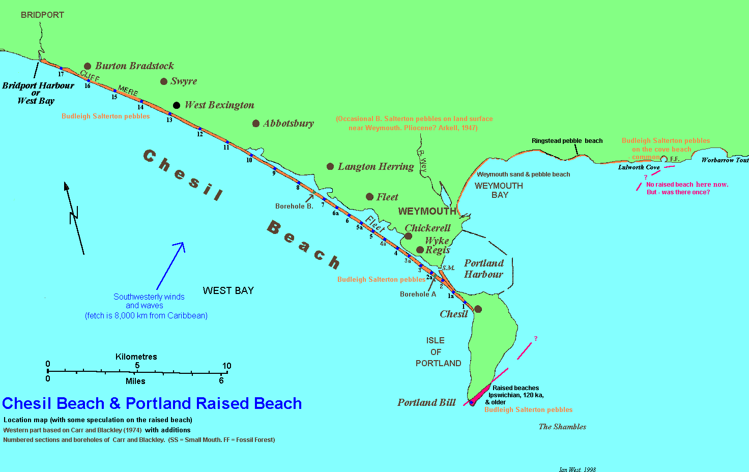
that extends southeastward from the west Dorset mainland to the promontory of the Isle of Portland. The western point at which it starts is arbitary but usually chosen at Bridport Harbour or West Bay (Arkell, 1947). There are harbour walls here which prevent transport of shingle from west to east, and the beach is now quite different on either side of Bridport Harbour. The Chesil Beach terminates 29 km or 18 miles away at Chiswell or Chesilton under the cliffs at the northwestern end of Portland. Here the beach is at its highest and the pebbles are much larger than elsewhere. The Chesil Bank is a very large storm beach, of simple linear type. Because it is connected to Portland, that would otherwise be an island, it is a good example of a tombolo.
The name of the beach - Chesil - probably comes from the (Old English ceosol, cisel = shingle). The beach faces the storm waves driven by the prevailing south-westerly winds up the English Channel from the Atlantic Ocean. The Portland end faces the open ocean until the Caribbean or Venezuela is reached.
For about 12 km it is in contact with the coast, but then for about 13 km it maintains an even curve at a distance of 200 to 1000 m from the mainland, enclosing between itself and the shore a shallow salt-water and brackish lagoon known as the Fleet. For the last 3 km the curve takes it out to sea to join to Portland, and here it is backed by Portland Harbour.
Opposite the Fleet the Chesil Beach is between 150 and 200 m wide, but it is narrower both adjacent to the cliffs in the west and at its extreme eastern end. Its width is 155 m at Abbotsbury, 182 m at Portland. There is a generally increasing ridge height from northwest to southeast. Its height is 6.9 m above high water mark at Abbotsbury and with a maximum about 14m above mean sea level near Chiswell where it forms a magnificent example of a storm beach (Davies, 1956).
Measurements were made at an early date by Sir John Coode (1853) and more recently by Carr (1981). On the seaward side offshore the beach drops at a broadly similar gradient to that of the seaward face above low water mark. The shingle extends to a depth below low-water mark of 11 m at West Bexington (some 270 m offshore) and also at Abbotsbury, to about 18 m at Wyke Regis (also at some 270 m offshore) and to 15 m at Portland. On the landward side, however, the shingle rests on a bed of clay 1 to 1.2 m below low water-mark.
The pebbles are well-graded, coarsest near Chesil (Chesilton) and diminishing in size towards Bridport. There is an old story that fisherman landing on the bank at night could judge their position by the size of the pebbles.
From Bridport Harbour to Cliff End, the shingle is piled up against the cliff. A hollow appears on its landward side at Burton Mere and near Abbotsbury Coastguard Station, and for the 13 km from Abbotsbury to Small Mouth it is separated from the mainland by the shallow lagoon of the Fleet. The western end of the Fleet is brackish and almost tideless, the consolidated shingle being practically water-tight up to ordinary high water mark. In the East Fleet, however, wide stretches of mud appear as the tide ebbs through Small Mouth.
The north-eastern shore of the Fleet has clearly never met the full force of the waves, which would cut such soft materials back in a continuous curve. Significantly, it has no cliffs on the landward side. It shows the form of a river valley like that of the Wey, and represents the left bank of a drowned valley. The Fleet is widest, up to 0.8 km or more, on the Oxford Clay and Fullers Earth, narrowing to about 180 m where the shore is of Forest Marble or Cornbrash.
The pebbles of the Chesil Beach are mainly flint and chert, derived from Cretaceous rocks, perhaps by way of Tertiary gravels such as those at Blackdown and Bincombe. Limestone and chert from the Portland Group are also common, especially at the eastern end, and another striking constituent is the discoidal pebbles of quartzite, red, purple ("liver-coloured" or white) such as occur in the Triassic pebble beds at Budleigh Salterton in Devon. Much rarer are pebbles of porphyry of a type that can be matched in the Permian breccia of Dawlish. Various tourmalinised rocks, red and black chert, vein quartz, etc., have been identified with the Palaeozoic rocks of Cornwall; many of them may have come like the flints, out of Tertiary gravels (Davies, 1956).
The first and simplest explanation of this assemblage of pebbles was that they had been swept by the waves along the shore from west to east, the usual direction on the south coast, and the larger pebbles had travelled faster than the smaller ones. Then, it was suggested that the Bunter pebbles, for example, had been swept across Lyme Bay (West Bay), either from the Budleigh cliffs or from a submerged outcrop; that they had been diverted at Portland and carried by the waves north-westward along the shore, suffering attrition on the way. It was Prestwich in 1875
who first pointed out that the Raised Beach at Portland Bill contained these pebbles, which had therefore come into the district in Pleistocene times when conditions were very different from those of the present day. Baden-Powell stated (1930) that the Raised Beach marks the earliest known date at which pebbles from the Dawlish breccia, from the Budleigh Salterton pebble beds, and perhaps from the Tertiary gravels were assembled in one deposit in the Portland district. The Raised Beach is only the remnant of a much larger deposit, formed when the Portland and Purbeck rocks stretched far to the west and east of what is now Portland Bill. North of the extended Portlandian escarpment the Fleet river deposited gravels, remains of which are seen at Fleet Common, at Langton Herring, and near Wyke Regis. It is from the sweeping together of the materials of these ancient shingles and gravels that the Chesil Bank was formed.
At present the beach is practically stationary. The pebbles drift sometimes eastward, sometimes westward, as the storm winds blow from W.S.W. or S.S.W. There seems to be a general movement towards a point near Chesilton, where the bulk of the beach is greatest and the pebbles are largest. These larger pebbles can only be moved by large waves, while the smaller stones my travel before smaller waves; this may have a sorting effect. There is a tendency for the beach to be rolled over on itself, and so to retreat toward the northeast, and this movement is most marked at the Portland end.
A smaller beach, the Portland Beach, stretches from the northern end of the Isle of Portland towards Weymouth, ending at Small Mouth (note that the position of this has been changed artificially). It is formed of limestone and chert of purely local origin. This also is now stationary, being protected by the Portland Harbour Breakwaters (Davies, 1956).
Offshore Geology
 This map, also shown on the main Isle of Portland webpage, is repeated here to show the Chesil Beach in its broader geological setting. The geology of the seafloor around Portland was investigated by Donovan and Stride (1961) by an acoustic survey supported by coring, the observations of divers and sample collection. This map is based on their work with some minor modifications (the geology of the offshore area is also shown on the British Geological Survey 1:250,000 Sheet 50N 04W, solid geology).
The major offshore feature is the Shambles Syncline. This plunges towards the east. Note how the southern tip of Portland, Portland Bill, is positioned on the axis. This is unlikely to be a coincidence. The progressive easterly swing of the dip from the north to the south of the island, as noticed by Strahan (1898), is because the northern part of the Island is situated clearly on the north limb whereas Portland Bill on the axis is an area with a dip that is controlled by the low angle of plunge of the axis to the east.
The Kimmeridge Clay occupies a considerable area of the seafloor and Portland Harbour lies over these easily eroded material. West of the Chesil Beach ichthyosaur and other vertebrate remains from the Kimmeridge Clay have been found on the seafloor by divers.
More Views of the Chesil Beach


Additional views of the Chesil Beach are shown here to give a better idea of its geomorphology.
The large aerial photograph provides a very good view from Abbotsbury, at the bottom, to the Isle of Portland in the distance. This shows the relationship of the beach to the Fleet Lagoon. The rough parallelism between the Chesil Beach and the margin of the land behind is puzzling. The photograph shows the morphology and shallow-water character of the lagoon. Note, incidently, the beach cusps on the seaward side of the Chesil Beach (What are the cusp-like features on the lagoon side?).
Amongst other features, this image shows particularly well the development of ravines at the back of the beach as a result of major seepage of water through the bank during storms. Arkell (1956) discussed the origin of these ravines at the Abbotsbury end of the beach, as shown here, in relation to a major storm in 1954: "Mr Hutchins of the Strangeways Estate Office, Abbotsbury, confirmed that, at the Abbotsbury
end of the beach, wave-tops and spray spilled over the top, but that most of the water came through, and he was able to throw some light on the nature and mode of the process of penetration. At the back of the beach, near the bottom of the shingle slope and running up into it, there is a series of ravines or gullies, separated by spurs or ridges of shingle. At the narrow, upper end of the ravines, sea-water bursts or pours through forming what are locally known as "caverns". One such "cavern" was said by Mr Hutchings to be about 10 ft. deep and about 100 ft. across after the storm of November 1954." Incidently similar but smaller caverns and ravines occur at the back of Hurst Castle Spit in Hampshire.
Arkell further commented that he visited the beach in April 1955 with Professor P. Allen of Reading University. He found the ravines and pits to be clearly visible. However, on the basis of relative freshness and discolouration of pebbles and from the absence or presence of vegetation, it found that it was clear that they date from different times and that many are ancient and have not been in action for many years, while others were fresh. The ravines and "coombe head" pits were found to vary greatly in size. Many of the ravines have twin runnels on the floor, separated by a tongue of fresh shingle, raised a few inches above the runnels on each side. An extinct mud-volcano was found. Arkell further discusses the Portland end of the Chesil Beach where sand dunes are being overwhelmed he found a sand-volcano.
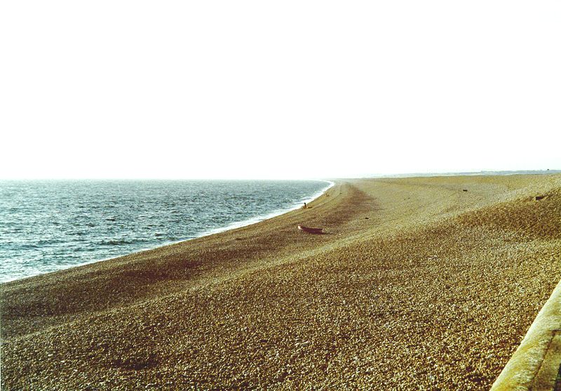
The bottom photograph, above, (taken in the 1990s) shows clearly some features of the Chesil Beach because of a low sun, and is provided here to give a low-level perspective of the beach to compare with the aerial photograph. As noted above the beach extends north-westward with the Fleet Lagoon behind it to Abbotsbury, and then mostly attached to the cliffs, further west to Bridport Harbour or West Bay. The maximum height of the beach, about 14m above mean sea level, is at this Portland end and there is a progressively degrease westward. The low sun is showing up the steps in the bank formed by various storms. Detail is shown in the inset with some of these emphasised. Notice that the higher steps are more widely spaced. Why do think this is?
Wave Action


Top left: The Chesil Beach in very calm conditions (18th October, 1998). There is a very small wave fringe and a light bluish-green sea.
Top right: The Chesil Beach with a strong westerly wind of about gale force (29th October, 1998). This wind is not south-west, the direction of very long fetch, but westerly and, therefore, with smaller fetch and the sea is relatively choppy with white wave crests. The result of this is much reworking of mud from the Kimmeridge Clay beneath to give a brownish tinge to the sea. The waves are only moderate in size, not very large and not extending far up the beach. Near Chesil, with its sea-wall, the waves are breaking quite strongly on the beach, and are followed by with the dangerous undertow of shingle washing backwards. Note that the Fleet Lagoon and Portland Harbour do not show large waves and are bluish and not discoloured appreciably by mud.
Bottom photograph - Please go to Chesil Beach Storms, Surges and Floods for information on severe wave action at the Chesil Bank.
(The wind often blows strongly on the exposed summit of Portland and this made the photograph a little expensive. As I opened the boot of my car, the westerly gale caught it with some strength and forced it into the back window, smashing the glass into small pieces!)

Moderate wave action is shown against the sea defences at the southeastern end of the Chesil Beach. These are primarily to protect Chiswell against flooding by wave action. Minor damage to these sea defences has already taken place. There is now some undercutting and exposure of sheet piling at the foot of the wall shown in the foreground. This part has also been slightly damaged by landslide movement.


The upper picture shows quiet sea conditions with a very small backwash. Divers are preparing to enter the water in the safe conditions at this time. The lower two photographs show moderate waves breaking obliquely on the Chesil Beach and a better developed backwash. The waves are from the west but the beach trends here, near the Cove House Inn, northwest-southeast. In the left-hand photograph the waves bring water obliquely up the beach transporting pebbles so that they travel to some extent southwestward. The backwash is directly down the beach as shown in the right-hand photograph. Repetition of the sequence of events shown by these photographs produces longshore drift towards the southwest. This is, of course, just the situation on a specific day. Often the waves are moving towards the beach at right angles.
The waves were only moderate on this occasion but the backwash was noisy with the pebbles grinding against each other. As mentioned above, there is a dangerous undertow here which has swept many a shipwrecked sailor back into the sea during storms.
------------------------------------------------------------------------------------------------------------------------------------------------------------------------------------
Footnote: The Undertow described in "Moonfleet" by J.M. Falkner, 1898.
Our village lies near the centre of Moonfleet Bay [Lyme Bay], a great bight twenty miles across, and a death-trap to up-channel sailors in a south-westerly gale. For with that wind blowing strong from south, if you cannot double the Snout [the Bill] you must surely come ashore; and many a good ship failing to round that point has beat up and down the bay all day, but has come to the beach in the evening. And once on the beach, the sea has little mercy, for the water is deep right in, and the waves curl full on the pebbles with a weight no timbers can withstand. Then if the poor fellows try to save themselves, there is the deadly under-tow or rush back of the water, which sucks them off their legs, and carries them again under the thundering waves. It is that back-suck of the pebbles that you may hear for miles inland, even at Dorchester, on still nights long after the winds that caused it have sunk, and which makes people turn in their beds, and thank God they are not fighting with the sea on Moonfleet [Chesil] beach.
[For pictures of a later shipwreck see part of Chesil - Lodestone website.]
-----------------------------------------------------------------------------------------------------------------------------------------------------------------------------------
Wave data has been given by Hardcastle and King (1972) on the basis of records over a two year period. The most frequent wave period was about 10 seconds. Most of the significant waves at Wyke and West Bexington exceeded 0.23m and there was a maximum wave height of about 8m during the two year period. Of course, at times, larger exceptional waves occur and these have caused flooding at Chiswell.
Beach Ridges and Terraces

From a distance in suitable light conditions a series of slopes, ridges and terraces are visible on the Chesil Beach. These, can be seen close-up on the beach but the subdued ones are not conspicuous. They mark the limit of wave action of previous storms. The photographs show some very well-defined ridges near the sea from very recent storms. Higher examples from some time back in the past are less-sharply defined. It is interesting that the beach in front of the sea-wall and promenade at Chiswell corresponds not to the top of the beach but to the highest terrace below the top slope.
Beach Ridge Irregularities

Irregularities in the beach ridges occur opposite the Army Bridging Camp on the Fleet Lagoon. This has been shown in photographs by Alan Holiday in late November and early December 2010. The area is where the direction of the bank seems to change rather more markedly than elsewhere, but no measurements have been made and the matter has not been studied. The reason for the irregularities seems to be some peculiarity regarding the wave pattern.
The matter at present, is not understood. Is it the result of some interaction of different wave patterns in the western and eastern parts of the Chesil Beach?
Another possibility might be that there is some of rip current or seaward current resulting from the wave action into this bend in the beach. A strong seaward current might possibly retard wave action or, as the white breaker in the photograph suggests, cause early breaking of the waves. At the moment it is a mystery.
Portland End of the Chesil Beach - Chesil Cove and Chiswell

The cliff top at West Weares, near Priory Corner and the Portland Heights Hotel is a good place to see the southeastern end of the Chesil Beach from above. Take care here; these students are keeping back a little. There are some high cliff edges that should not be approached too closely. Looking down from this area you can see much old quarry debris - "Weares" and natural cliff-falls like the topple that is moving away from the cliff in the left-hand photograph. There have many landslides here, including one that was regarded locally as an "earthquake". The toppling block is of Portland Cherty Series with sheets of hard black chert with a whitish exterior. The limestone and chert is naturally supplied to the Chesil Beach. The limestone does not travel far from Portland. It is relatively soft and easily eroded in the mill of very hard pebbles. The chert is much more resistant, being as hard as the flints, quartzites and other chert of the Chesil Beach. It can be recognised by the presence of Portland fossils. The foot of the cliff here is the source of supply to the beach.


For further studies of the Portland end of the Chesil Beach some aerial photographs are shown here. With it is part of an 1892 map (from Lilley, 1892 ) showing the area when the development was limited. See Legg (1976) for more information on this map. It is not known whether at this date the railway line would have held back floodwater coming over or through the beach, but previously this would drained away to the Mere or Mare lagoon at the back. Detailed study of various maps, like this, is useful for establishing the rate of landward retreat of the Chesil Beach (only about 17 cm per annum, or 17 metres per century on average, excluding any new increase due to global warming).

At Chiswell or Chesil, the village is, for historic reasons, very close to the backslope of the Chesil Beach. The bank looms over some of the housing and there is, of course, an interesting history of events in this area. See the Chesil Beach Storms and Sea Defences Webpage for more information
The backslope is steeper here than at the Chesil Beach Centre and washover fans are not so obvious as they are there and beyond to the northwest. Of course, some very old fans are likely to be under certain of the buildings (potentially detectable in boreholes) but they have not been mapped and no details are not known. They are unlikely to extend beyond the road. Note that the beach crest is higher in this Chesil Cove area and, although serious floods occur from time, it is possible that hurricane washover is a less frequent event here than at the Chesil Beach Centre and along the Fleet Lagoon.
LOCATION:
Chesil Cove at SE End of the Chesil Beach;
and Coastal Retreat


The Chesil Beach is attached to the corner stone of Portland Island. However, it has not reached stability. As Arkell (1947) pointed out in each great storm pebbles are cast over the top, and they roll down the back slope never to return. The beach is therefore very slowly rolling over on itself. The lack of vegetation on any part of the bank at the Portland isthmus shows that this process is going on faster there than elsewhere (examine the photographs provided here to confirm the difference in vegetation cover). Before the sea-wall and promenade was built as Chiswell there was a small cliff-like bank on the seaward side of the top of the bank. This can be seen in old photographs. The Cove House Inn has been built on the landward side of this small cliff. It seems to have been composed of pebbles and the rubbish of the old village, accumulated originally on the inner side of the bank. The sea was cutting this back before the sea-wall was built. An indication of the height of this cliff is shown by considerable difference in level between the top of the sea wall (and the base of the Cove House Inn) and the beach in front of it.


These photograph shows a shipwreck in Chesil Cove with a former, but now obscured, cliff present behind the ship (and with a recent photograph for comparison). The Madelaine Tristan was driven ashore in Chesil Cove in the morning of 20th September 1930. It was one of the later sailing ships to be caught in "Dead Mans Bay". According to Morris (1989) most of her grain cargo and all her crew were saved, but she was a total loss, her hulk remaining high and dry on the beach for many years. The storm photograph shown above is reproduced from the book "Portland Camera" by Stuart Morris with the kind permission of The Dovecote Press. Photographs have also been published in Morris (1989) (see his photographs 50 and 51) with some comments. Another photograph above is from an old postcard.
The photographs and other photographs of about this date and earlier, back into the 19th century, show a sea-cliff at the back of the beach just south of Brandy Row, Chiswell. Significant erosion was taking place here in 1930 in relatively unlithified material with boulders. This is a short section of unvegetated retreating cliff. This is now obscured by sea-defences which were built about 1960.
Arkell (1947) described the cliff which is shown here. His studies were made in the 1930s, not very long after this photograph was taken, but because of the Second World War the publication was delayed. He said:
"At the north end of the Island, in the cliff near the end of the Chesil Beach at Chesilton, there is as spectacular section of angular rock debris consisting entirely of Portland and Purbeck Beds, exposed to a thickness of about 50 ft. The blocks are of all sizes. Here and there they show rough stratification in various directions, and here and there enormous angular rocks are supported in a gravel, or the gravel passes into seams of loam resembling that at the Bill. From a thin loamy seam near the base Prestwich recorded Bythinia, Planorbis, Limnaea and Pupa and he classified the whole as Head. It may be as old as the Head but in origin it is clearly landslip debris from the old high cliffs of Portland Stone above. It can be seen to pass up continuously from the beach to the parent cliff, climbing to a height of 352 ft (107m) in a horizontal distance of 1,250 ft (381m), and at the top it merges into a huge landslide, a foundering cake of Portland Stone tilted seaward. Marsh shells are often to found in recent landslips, as at Holworth House and Osmington mud-slides, for as the rocks tilt and founder they give rise to enclosed hollows in which ponds can form and may survive for many years. All that can be said as to the age of this particular debris is that formed since the formation of the cliff that now bounds the north side of the island, but it long ago reached a state of repose and is only now being attacked and redisturbed by the encroach of the sea."
The type of landslide in the upper part of this deposit, characterised by a seaward dip, is unlike those on the rapidly eroding west coast of Portland, which are mostly rotational in a landward direction. Instead it has some similarities to those on the eastern and northeastern coast of Portland (Walshaw, 1993) where the dip of the slipped material is often seaward. The age of the landslide described by Arkell, and by inference, the age of the deposit of the former cliff is not clear. If the rubble deposit is really "Head" then a late Pleistocene age (Devensian?) is implied.
Older photographs from 1890 (see "Portland Camera") show the cliff with much the same form. The beach, however, had greatly retreated by the 1930 storm and the bedrock, the Kimmeridge Clay seems to have been exposed under boulders of Portland Stone. There were no sea-defences in 1930 and Brandy Row seems to open straight onto the Chesil Beach. The low cliff-like bank visible here at the landward edge of the beach is probably the place where it has been said that debris of the village (amongst pebbles?) was being eroded by sea. Morris stated that "Successive storm waves had broken chunks off the low silty cliff in the foreground, all that stood between the ravenous sea and the cottages at the top end of Brandy Row".
However, the normally shingle-covered blue clay, the Kimmeridge Clay was exposed on the foreshore, and this is visible in the photographs. Thus a small cliff to which one end of the Chesil Beach was effectively tied was eroding back, although probably slowly and at irregular intervals.
Retreat of the Chesil Beach in General
At Abbotsbury peat is thrown back onto the top of the beach during storms. This peat has clearly come from the front of the beach below water. It is several thousand years old, and bones of a beaver have been found in it by David Harvey (personal communication from DH, 2001). A small amount of peat has also been seen by the present author on the Chesil Beach at Chiswell.
All this shows quite clearly that there is some landward movement of the beach. Now the rate has to be determined.
Carr and Gleason (1972) and Carr (1981) discussed the rate of recession. One stretch of the beach where it is narrowest opposite Portland Harbour shows 17m recession from the 1850s to 1968/9. The retreats elsewhere are too small to be determined because the surveys are not sufficiently accurate. Carr (1981) stated that localised retreat of the crest from opposite Portland Harbour to Chiswell in the storm of February 1979 was of the sam magnitude as the long-term recession opposite Portland Harbour. The indications are, then, of about 17cm landward movement per annum on average in the Portland Harbour to Chiswell area, and probably less elsewhere. Obviously the retreat is very erratic and drastic changes can take place during storms.
The retreat of the West Weare Cliffs at the southeastern end of the Chesil Beach has been studied by Williams (1992). Surveys of 1927 and 1978 were used and data for 11 locations was averaged. The calculations were made for both low and high water positions, and, although only approximate and with much variation between localities, give an indication of the amount of recession. The low water figures average 6cm and the high water figures average 20cm. The average of both these, 13cm, is broadly similar to Carr's figure for the Chesil Beach.
It seems reasonable to conclude that the western side of Portland and the adjacent Chesil Beach is retreating at a rate of round about 15cm per annum or 150m in 1000 years.
The implication of this is that at the present rate of recession the Chesil Beach and the west cliffs of Portland would only have been 1.5 km offshore from the present coastline at the beginning of the Flandrian Transgression, 10,000 years ago. This does not seem to agree with the evidence that the whole English Channel was dry at the start of this rise in sea-level. If the Isle of Portland was a hill not extending far to the west prior to the transgression then it is probable that the early transgression over the low ground was far more rapid. If Portland is, instead, the remains of a large limestone upland previously extending far to the west it is difficult to explain the situation. The Chesil Beach and the limestone hill to which it was tied could not have retreated fast enough. All this is good evidence for the pre-Flandrian shaping of the Portland upland.
Storms and the Chesil Beach
Please go to Chesil Beach: Storms and Floods.
Sea Defences and Flood Defences
Please go to Chesil Beach: Storms and Floods.
Blown Sand at Small Mouth and Chesil
As mentioned above the beach tends to roll over on itself. Near Chesil (Chesilton) it appears to have overwhelmed blown sand according to (Davies, 1956). Presumably dunes have developed from beach sand on the Portland Harbour side. Blown sand covers a small area at Small Mouth under the torpedo works and also on the opposite side of the Fleet, but it is buried under shingle from the Chesil Beach and seen only in excavations (Baden Powell, 1930;Arkell, 1947). Shingle from the beach was thrown over the blown sand in the great gale of 1824, according to J.B. Groves, Nature, vol.10, 1875, p. 506.
Abbotsbury Area - Chesil Beach


These photographs show the relatively finer part of the Chesil Beach near Abbotsbury. The top left photograph shows the "Dragon's Teeth" (Second World War anti-tank defences against German invasion) which cross the beach at Abbotsbury, at the western end of the Fleet lagoon. Top right shows a gun-emplacement at the seaward end of these which has now collapsed down the bank. This concrete blockhouse would presumably have been on the crest of the beach in the war. The side hole seen here would have enabled a machine gun to rake any possible German invading force on the beach to the west. The collapsed position in which it is now, seaward of the crest, could provide an indication of the amount of landward retreat of the beach crest since about 1940.
The lower left photograph shows the view looking southeast showing a storm level in the bank of relatively fine-grained shingle. The waves which built up this bench have left a trash-line of seaweed and plastic debris. The lower right hand photograph is from 1.2 km further southeast, showing the top of the Chesil Beach and the Fleet Lagoon, with Berry Knap and Higher Barn behind. This hill is of north-dipping Cornbrash (Middle Jurassic shelly limestone). Note that here too the top of the beach is flat and that some vegetation has become established.
Southeast of Abbotsbury, magnetite, the magnetic iron-ore known as lodestone has been found in some quantity on the beach. This is probably from a shipwreck, and an account is given in a separate web page: Chesil Beach - Magnetite, Lodestone, Pebbles.

This image shows the typical beach shingle in wet condition, a few hundred metres south east of the anti-tank defences near Abbotsbury. The small pebbles of a yellowish-brown colour, which are dominant, are probably mostly of flint and are subrounded to rounded. Some dark pebbles may also be of flint but without a yellowish cortex. Some black chert may be present in small quantities.
Light grey to whitish pebbles are probably of Upper Greensand chert, which is common in the beach. Note that the beach material is very well-sorted.
Also shown is one of two
Portugese Men-of-War (Physalia sp.) found washed up on the beach here on the 18th of October, 2000. These are pelagic colonial hydroids or hydrozoans which live in tropical water and in the Gulf Stream and have a float bladder containing nitrogen. They are notorious for a painful and serious sting (the poison of the sting is a neurotoxin 75% as powerful as cobra venom). This specimen is presumably dead but should not be touched, of course. Portugese Men-of-War are not uncommon on the Chesil Beach and warnings have been given in the summer to bathers in the Weymouth area to watch out for these.
Western Limit of the Beach
The western limit of the beach is arbitrary because it links to the cliff-line in the west and criteria have to be given to define its limit (Carr, 1981). Should it be at the end of the Fleet Lagoon? Should it be consistency in the longshore size grading of the beach material (i.e. the location where the smallest pebble size becomes minimal)? Should it be the continuity of the crest line (the western limit of the continuous crest)? It has been drawn variously at Abbotsbury (at the end of the Fleet Lagoon), at West Bexington (further west, fixed on particle size grading), Burton Cliff and West Bay (where the sediment size is small and the beach is broken by the harbour mouth). Carr (1981) suggested that it may be changing with time. As the beach moves slowly landward as coastal erosion takes place, various segments between Abbotsbury and West Bay become more isolated from each other and from the main stretch of the Chesil Beach further east.
.

.
In the past, West Bay, Bridport was usually considered to be the western or northwestern end of the Chesil Beach. The wall of the harbour prevents the continuity of natural beach processes here, and the shingle is very fine, and becomes progessively coarser to the southeast. However, in recent years the shingle beach has become disconnected or partially disconnected at Burton Hive Beach. To the west of here the relics of the Chesil Beach still exist at beach shingle as far at the new harbour at West Bay, but the beach in this area has only, now, (mostly) a one-way connection at Burton Hive Beach, and that is southeastward. In other words from Burton Hive westward there is just a three kilometre relic, that is gradually reducing by seaward loss of sediment. The new harbour and sea defences at West Bay have effectively closed any western supply. The Burton Hive "gate" has almost closed supply from the southeast. So the Chesil Beach is a shorter beach now and it is a loser. It no longer is a feature of fixed shape and no longer independent of the rock type or resistance of the cliff. It will erode back the Frome Clay and in the long term close the Fleet Lagoon. It is not the former unusual, separate and special Chesil Beach at Burton Hive and adjacent area but just an ordinary coastal beach that allows storm attack on the cliffs.
Bridport End of the Chesil Beach

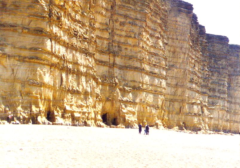
The beach at West Bay or Bridport Harbour is usually regarded as the western end of the Chesil Beach. In the left-hand photograph we are looking eastward, with Portland in the far distance. Here the composition of the beach is broadly similar but it is fine shingle with rounded granules of only a few mm in length. In the right hand photograph this beach can be seen banked up against cliffs of Bridport Sands. The top of the beach is not very high here compared with the Portland end. For more on the Bridport area see the Briport Field Trip Guide .
Was the Chesil Beach Once Breached?
"In exceptional storms, the sea seems to have gained access somewhat freely to the Fleet. Leland, writing in 1546, speaks of the south-eastern winds breaking through the bank (see below).
Camden, in 1590, says:
the Chesil Beach: " when the south wind rises, gives and commonly cleaves asunder."
Whatever this expression may mean, it is recorded that on November the 23rd, 1824, the sea-water stood to a depth of 22 feet 8 inches on the alluvial meadows of the Decoy, near Abbotsbury, this result having been brought about not so much by the giving way as by the overtopping of the bank by waves at high tide. In the same year the sloop Ebenezer, of 100 tons, ran on the crest of a wave so high up the bank that she was subsequently launched into Portland Roads. This occurred midway between Ferry Bridge and Chesilton. " (Strahan, 1898).
In the 1824 gale the crest of bank in places was washed over the back and many fishermen's cottages at Chesilton were destroyed killing 50 to 60 people. On another occasion, in January 1853, a vessel was lifted by a wave and perched on top of the bank two miles from Small Mouth, and everyone aboard was saved (Arkell, 1947).
The Chesil Beach in Historic Times
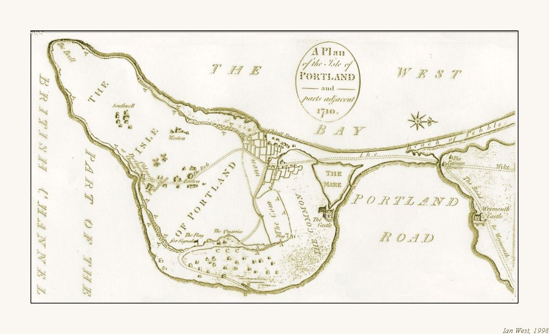
The 18th Century map and the 19th Century etching, below, show the Chesil Beach and northern Isle of Portland before development. Notice the Castle and also the Mere. The latter was a small lagoon, much infilled with mud by the time of the sketch and later, when the railway reached Portland, completely infilled. It is now the helicopter base.
Please look carefully at these illustrations before reading the text of Leland below. He refers to some of the features seen here and it may have looked much the same in his day as shown in the map and sketch. There had been few changes to the middle part of the 19th Century, but after that there was much development. It has been suggested that the Mere and the Fleet were once connected. Do you think from your reading of the text that this was the case when Leland visited? Was Small Mouth present or did the Fleet connect to Portland Roads through the Mere? Is Leland referring to an entrance next to the castle? What do you think? There is a clue on the old map.


Leland's Description of Portland and the Chesil Beach (1546)
" This arm (viz. that runneth up by the right hand of Waymouth Haven to Portland Passage, see Waymouth) going up from the Strait of Trajictus, and is of good bredth, and so se goith up to Abbates-Byri, about a vij. miles of, where is a litle fresh water resorting to the se. A little above Abbates-Byri is the head or point of the Chisil, lying Northe Weste, and from thens streach up 7 miles, as a maine narow banke by a right lin on to South Est and ther buttith on Portland, scant a quarter of a mile above the new castall in Portland. The nature of this bank of Chisil is such, that as often as the wind blowith strene (f. strong) at South Est so often the se betith it, and losith the bank and breakith through it. So that if this might continually blow there, this bank should soon be beaten away and the se fully enter and devide Portland, making it an isle, as surely in tymes past it hath beene, as far as I can by any conjecture gather. But as much as the South Est wind dooth bete and breke off this Chiselle bank, so much doth the North West wynd again socor, strength and augmentith. On the farthest point of the Trajectus into Portland, comming from Waymouth, is a point of land like a causey al of pible and sand, cast up by the rages of the se. Wheron I went scant a mile, to the lowest part of the rotes of the high ground of Portland, wher a late a right strong and magnificent castel is builded at this causey end. And from this castelle to the very South Est point of the Chisil, is but a little way: and the arme of the se that goith up to Abbates-Byri, gulfith in bytwixt the South Est point of the Chisel and the castelle."
" Portland has been of auncient tyme, by all likelihod environid with the se, and yet berith the name of an isle. It is eminent and hilly ground on the shore of it and a great plain in the midle of it. The cumpace of is counted to to be about a 7 miles. But if a man should cumpace by the very rootes, and depe shore would mount to a 10 miles. The soil is somewhat stony; and the shore is very rokky."
"The isle is fruiteful of corn and gresse and hath plenty of sheepe. Ther be at this present tyme about a 80 housis in the isle."
"Ther hath been almost as many mo, as it apperith by the ruines. Ther is but one streat of houses, in the isle the residue be sparkelid. There is a castelet or pile not far from (the) streate, and is set on a high rokke, hard by the se cliffes, a little above the Est end of the cherch. the paroche cherch, that is but one at the tyme in the isle, is longe, and sumwhat low buildid in the hangging roots of a hill by the shore. This cherch and paroche is about a mile -- -- to go the next way to it from the Kinges new castelle, in the isle; and to go to it by cumpace of the shore it is 3 miles, or more. Sum say that in tymes past, ther was another paroche chirch in the isle; but I there lernid no certente of it. There be very few or utterly no trees in the isle, saving the elmes about the chirch. There wold grow more, if they were ther plantid; yet is the isle very bleke. The people bring wood thither, out of Wight and other places. They brenne also cowe mdung dryed with the hete of the sunne. The people of the isle lyve most by tillage, and sumwhat faulle from fishing.
"
"
The people be good there in slyngging of stonys, and use it for defence of the isle. The people ther be politique inough in selling their commodities, and sumwhat avaritiose. The personage sette in the high steat is the best building in the isle. The bishop of Winchester is patrone of the chirch. The isle is the Kinges; and much of the land there is holden by ........ of hym. "
(Leland, 1546. Leland's Itinerary, volume iii, pp. 66, 67)
(This is not really relevant but, while on Portland history, I cannot resist adding this extract from the discussion between an 18th Century visitor and a local (from Hutchins, 1861). This Portland custom is now more widespread elsewhere! :
"--- and it has been the custom of the island, from time immemorial that they never marry til the woman is pregnant"
"But pray," says I, " does not this subject you to a great number of bastards?
Have not your Portlanders the same kind of fickleness that Englishmen are subject to; and in consequence does this produce many inconveniences.?"
"None at all" replies Roper.
)
Evolution of the Chesil Beach - the main Flandrian (Holocene) Development
The origin and evolution of the Chesil Beach and the Fleet Lagoon is still not fully understood. The present beach has formed since the last glacial phase (the Devensian) of the Quaternary Ice Age. The ice had advanced to an approximate east-west line from somewhere north of London to near Bristol. It is not generally thought to have extended to this area which was periglacial tundra, although a controversial theory by Kellaway et al. (1975), not widely accepted, argued for an English Channel glacier. At that time of the last glacial the sea-level was so low that the English Channel was dry land. This, however, was progressively flooded from about 10,000 year BP (before the present), and the evolution of the beach is related to this flooding, the Flandrian Transgression (see notes on sea-level below).
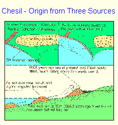
It seems likely that the present beach began as a bay bar along the coast of former lands of West Bay when the sea-level was lower but rising and gradually flooding the bay. Arkell (1947) postulated that the existing beach began its life at the beginning of the Neolithic submergence as a bay-mouth bar stetching from an extended Portland Bill westward across what is now West Bay (Lyme Bay) to join some lost headland of Cretaceous and Tertiary rocks seaward of Beer Head and Dowlands Cliff. As sea-level rose this old coast was modified and worn back. Destruction of its outcrops and headlands combined with longshore drift to mix Tertiary gravels (already containing "south-west" material, of course) and Budleigh Salterton quartzites and move them east. This theory has been generally accepted (e.g. Davies, 1935)
Evolution of the Chesil Beach - the Problem of the Budleigh Salterton Pebbles
The Budleigh Salterton (Bunter) quartzites are valuable indicators of provenance. They are very easy to recognise, at least the liver-coloured ones. There is one specific original source area. However, as always, the story is more complex than it first appears. Budleigh Salterton pebbles occur not only in the Chesil Beach but also in the Portland Raised Beach (or beaches). Occasional specimens are found on the land in the Weymouth area (Arkell, 1947) , and some, surprisingly, are found on the beach at the back of Lulworth Cove (particularly in the north-eastern part). They are also found as lag concentrates on the sea floor of the English Channel, according to Kellaway et al. (1975).
Any explanation for the origin of the Chesil Beach has to explain the presence of these quartzites. They could travel eastward by longshore drift (with prevailing southwesterly winds and waves). However, there are problems at Otterton Point (SY 079819), near Budleigh Salterton and at Beer Head (SY 228878) near Seaton. There are no beaches at these headlands and pebbles cannot pass them by longshore drift in an easterly direction. Beer Head is a 120 m Chalk cliff, with the sea at the foot of cliff on the eastern side and is an obvious obstruction. How could pebbles get past this?
The general explanation for the origin of the Chesil Beach as given above was partly based on some form of direct transport eastward from Budleigh Salterton in the past and partly on Strahan's (1898) argument that the Chesil Beach represents the winnowings of lost land in West Bay. Strahan argued that because the pebbles cannot escape around the cliffs of Portland the Chesil Beach represents the accumulated gravels of the whole of the land-surface that once occupied West Bay (Lyme Bay).
He commented more specifically on the Budleigh Salterton pebbles. " The occurrence of the quartzites has caused much speculation as to the power of the waves and tides to roll pebbles along the sea-bottom, for it was assumed that they must have brought directly from Budleigh to the Chesil Beach . Their presence, however, in the Plateau Gravels (i.e Pleistocene gravels) shows that they may have travelled at a far earlier date that was supposed and at a time when conditions were altogether different from those of the present day. The Plateau Gravels, it will be remembered, were not improbably contemporaneous with the Glacial Deposits of other parts of England and themselves show indications of the action of ice. The Bagshot Beds, moreover, which, of course, must have extended over much or perhaps all of the district, contain a variety of far-travelled rocks, and probably yielded much of the material of the Plateau Gravels.
The mapping of the Plateau Gravels show there must have been at least two extensive sheets at different elevations on the north side of the Fleet, while a still more important deposit overspread the high ground at Abbotsbury. We may reasonably assume that these gravels were no less plentiful on the south side of the Fleet, and formed a souce capable of having supplied both the raised beach of Portland Bill and its modern representative the Chesil Bank. "
Arkell (1947) did not like this theory. He said "Though it is true that the winnowings of lost land in West Bay are represented in Chesil Beach, Strahan's explanation is unsatisfying. The Tertiary and Quaternary gravels of the land that still remains adjacent to the beach, and that which will be next fodder for the sea, would be utterly incapable of supplying the millions of small and large Bunter (Budleigh Salterton) quartzite pebbles so conspicuous on Chesil Beach, or the large quantities of Permian porphyry. In the (Pleistocene) Plateau Gravels Bunter quartzites are extremely rare and none is known exceeding 5 inches (12.7 cm) in diameter. No porphyries have been found. Strahan's theory is only plausible if it be assumed that on the lost land far out in West Bay some ancient river flowed from the west and brough with it deposits of gravel differing entirely in composition from those of the early Frome or the streams of the Weymouth District. " (Arkell went on to discuss the floating ice theory)
Arkell noted that " there at present a much higher proportion of quartzite pebbles in the coarse-graded part of the Chesil Beach from Small Mouth to Chesilton than in the Raised Beach. This at first suggests a replenishment since Raised Beach times, but it may be accounted for by concentration of the largest and hardest pebbles here owing to their relative indestructability, from a much longer stretch of destroyed Raised Beach."
(this will be continued)
Sea-level Changes - for background information
Some details of sea-level changes are given here for reference: Estimates of Holocene relative sea-level rise in southern Britain (Bell and Walker, 1992) suggest that in the Bristol Channel area sea level rose from around -35m OD at 9.5 ka BP to < -5 m OD at 5 ka BP at the following rates: 9-8 ka BP - c. 1.2 cm per year; 8-7 ka BP - c. 0.9 cm per year; 7-6 ka BP c. O.4 cm per year, 6-5 ka BP - c. 0.2 cm per year (Heyworth and Kidson, 1982). In the Thames Estuary, broadly comparable figures of c 1.3 cm per year between 8.5 and 7 ka BP and 0.5 cm per year between 6.5 and 5.0 ka BP have been obtained (Devoy, 1977). At Fawley, near Southampton, sea-level rise in the last 6000 years has been about 0.1 cm per annum (Hodson and West, 1972). Now there are high sediment accumulation rates on mudflats and saltmarshes of Southampton Water (Cundy, 1994) which ties in with evidence elsewhere for a rate of sea-level rise of somewhere near half a centimetre per annum at present. The general pattern is one of a high rate of relative sea-level rise to about 6,000 BP and then a slow rate, with a possible significant increase since the 1940s. It is intended to discuss these matters more fully in the Solent section of geology guides in the future, and with a more complete reference list.
By about 6,000 years BP the configuration of the British coastline was comparable, in terms of its principal elements, with that of the present day. However, as Bell and Walker (1992) noted, it was considerably more indented at that time because of the drowning of many small valleys to form estuaries which have since silted up. The early Chesil Beach was probably not as smooth, straight and regular as now, hindering or preventing the transport of Budleigh Salterton pebbles, a topic discussed further below.
Beach Pebbles - More Detail
Please go to Chesil Beach Pebbles
See also: Chesil Beach Magnetite, Lodestone, Pebbles
Hurst Spit - Comparable Shingle Bank

Go to:
|Hurst Spit?
COMPARISON - Another Tombolo - the "Chesil Beach and Portland" of Cyprus


Tombolos are fairly common geomorphological features. They consist of a beach ridge of pebbles or sand that connects a former island to the mainland. We will consider here an example pebble tombolo in Cyprus, that has been compared to the Chesil Beach (Greensmith, 1998). Gaining some understanding of another tombolo, even though it is very different, may help in some respects in interpretating the origin of the Dorset Chesil Beach The map above of the Cyprus promontory shows the obvious similarity to the Chesil Beach, Portland Harbour and the Isle of Portland. However this example is smaller than the Chesil Beach and does not show the remarkable sorting of the pebbles.
(Note: The photographs of Cyprus have been chosen and modified to show only geological and geomorphological features. They have been photo-edited with some irrelevant non-geological content removed. In some respects they may not entirely accurate and are reliable only for geological purposes. Resolution is limited by small pixel number and no high-resolution versions exist. The images are copyright and not available for reproduction.)


The Espiskopi Bay Tombolo Beach is a sort of "Chesil Beach" at Akrotiri, near Lemosos (Limassol), Cyprus. It connects a "Portland" of limestone (in that case Miocene to Pleistocene limestone) to the mainland. Photographs above show the southern ends of both the Dorset tombolo and the Cyprus tombolo, with more detail of the latter beach below. The beach of the Akrotiri tombolo is lower, presumably because of lower wave heights in the Mediterranean Sea, where the fetch is much less. It is also shorter than the Chesil Beach.
The beach material is less resistant, consisting of white limestone pebbles and of the dark-grey igneous pebbles from the Troodos Ophiolite. At the southern end, as shown in the photograph above, in places there seems to be a very high proportion of igneous material. These pebbles are subrounded rather than rounded as are the pebbles of the Chesil Beach in Dorset. In contrast with this southeastern part, there seem to be more limestone pebbles at the famous archaeological site of Kourion (Courion or Curium), further to the northwest and near limestone cliffs.
South of the Cyprus Tombolo Beach
The photographs that follow show something of the relatively high limestone area, the former island, to the south. This area, between Cape Gata in the east and Cape Zevgari in the west, would be the equivalent of the Isle of Portland, although not with the same orientation. Relate these photographs below to the aerial views that follow.


Views here show the cliffs of nearly horizontal limestone to the south and between Cape Gata and Cape Zevgari. Parts of these are of about 80m in height, but they are lower from Dreamers Bay westward. Fine-grained, almost chalky Miocene limestone of the Pakhna Formation is at the base of the cliffs with bioclastic limestones of Pliocene and Pleistocene age above. A raised beach occurs at a lower part of the cliffs and this resembles the raised beach area of Portland Bill in some respects.
There is a good cliff-top path, the Dreamers Path and this is accessible only to residents of the base and their visitors with special permits. It is a pleasant walk much resembling the Range Walks of Dorset, particularly the trail on Gad Cliff. Several ancient graves and other archaeological monuments are passed and Roman pottery sherds are widespread. The most famous locality within this area is at Aetokremnos, the "Cliff of the Vulture" (or Eagle). This is famous for the rock shelter with numerous bones of pygmy hippopotamus and pygmy elephant, together with Mesolithic scrapers, dating from 10,500 years BP. The ledge is about half-way up the cliff slope above a vertical cliff. It is a dangerous place on the edge of a vertical cliff and 40m above the sea; there is no good path down to it and it is certainly not recommended to try to descend to it. Cliff-falls are now reducing the width of the ledge. If it is approached by scrambling down the debris of the cliff there is serious risk of taking a disastrous route by mistake or of slipping on the loose rock and falling into the sea. Signs above the cliff draw attention to the dangers and in particular warn that children should not approach these hazardous cliffs.
Thousands of bones have been excavated from the Aetokremnos site. It was discovered in 1961 and excavations took place in the 1980s and 90s. Now there are many publications on the subject, even books, and they include other photographs of this important site (see for example: Mandel and Simmons (1997)). There have been arguments about whether the humans killed off the hippopotami and elephants or not - but for this discussion it necessary to follow the literature further. The Mandel and Simmons paper is useful for providing references.
Akrotiri Salt Lake


In aerial views the relationship of the pebble beach to the original limestone island to the south clearly visible. Old maps (see above) show that there was once a much larger body of water east of the beach. There seems to have been much natural reclamation and probably also much artificial reclamation of the original harbour or estuary. This is now just a saline lake that can dry out to a salt crust in summer (although, unusually, it did not dry in 2004). In the marshes of its margins are marine molluscs, particularly Cerastoderma but also with Conus which is common in the sea here. This proves the original sea-connection.
In the aerial view notice the dry braided system of the Kouris River which has brought clasts of ultrabasic and basic igneous material from the Troodos Massif. The river mouth forms a small delta protruding seaward from the general line of the beach. On the old map a branch of this river is shown entering the salt-lake area.


In the central part of the beach, particularly near the conspicuous shipwreck, there is much beachrock developed. The beach clasts are cemented by calcium carbonate into a conglomerate. Most of this is sandstone, but there is conglomerate at the landward side of the beachrock reef. There is a seaward dip to the bedding. The beach has retreated landwards from the beachrock so that if forms a reef parallel to the present shore but only a short distance seaward. The ship may have been wrecked on the seaward part of the beachrock.
An interesting feature of the tombolo is that an artificial bank, built at the back of the beach to prevent flooding of the hinterland, collects much pummice which as a floating substance is cast over the beach.


The southern limit of the pebble beach is marked by a small promontory. This location is referred to as 'Monument Point' because it has a memorial to a British Officer killed during training. The little headland is of aeolianite (dune sand cemented into sandstone, usually with low-Mg calcite) with excellent rhizoconcretions (carbonate concretions around plant roots, probably of low-Mg calcite). The rhizoconcretions are seen as horizontal former roots spreading from the former base of the plant. No large tree remains were seen and the roots were probably associated with shrubs like those growing in the are at present. Although obviously Quaternary the precise age of the aeolianite is not known. It is either associated with the present post-Flandrian Transgression sea-level or with the last Interglacial high (Ipswichian). I do not yet know whether there is detailed literature on this deposit. The present tombolo beach is later in origin than the aeolianite.
A short distance inland of here are cemented sand-dunes forming a ridge of small hills. The photograph above shows the cross-bedding in the cemented dune sand.
(to be continued)
SUPPLEMENTARY REFERENCES, RE CYPRUS
For most references go to the Chesil Beach Bibiography. Some additional references regarding Cyprus are given here.
.
Erol, O. (1991) Turkey and Cyprus, In: The World Coastline. E. Bird and M. Schwartz (Eds.) 491-500, Van Nostrand Reinfold Company, New York.
.
Mandel, R.D. and Simmon, A.H. 1997. Geoarchaeology of the Akrotiri Aetokremnos Rockshelter, Southern Cyprus. Geoarchaeology, 12, No. 6, 567-605. By Rolfe D. Mandel
Department of Geography, University of Kansas, and Alan H. Simmons, Department of Anthropology, University of Nevada at Las Vegas.
Abstract: Akrotiri Aetokremnos is a collapsed rockshelter on the southern coast of Cyprus. Excavations revealed a 1-m-thick package of sandy deposits preserved beneath massive rooffall blocks. These deposits contained cultural materials in direct association with extinct pygmy hippopotamus and other fauna. Based on 31 radiocarbon assays, the site
was occupied around 10,600 B.P. Four major stratigraphic units were defined, with cultural features and artifacts concentrated in Strata 2 and 4. Most of the sediments
that accumulated in the rockshelter are a product of roof fall, disintegration of bedrock (attrition), and wind action. In addition, a small volume of slopewash entered the back
of the shelter through solution cavities and is confined to less than 5% of the site. Although some of the strata have been slightly affected by leaching and clay translocation,
there is no evidence of soil development in the shelter. The physical and geochemical properties of the strata indicate that the sediments and associated cultural materials
rapidly accumulated on the floor of the shelter soon before the roof collapsed and isolated the underlying deposits from subareal weathering and other site-disturbance
processes.
Appendix - Chesil Beach Field Trip
Various field trips for students relating to the Chesil Beach are possible. Some details of one type of trip are given below. There are, of course, many possible variations on the theme, and the trip could be modified to include Abbotsbury and Bridport.
Civil Engineering and Oceanographic Field Trip to the Chesil Beach and the Isle of Portland.
11 am. Start at at Portland Bill car park.
View the coast at Portland Bill. Discuss the broad scale preservation and
erosion of the Isle of Portland in relation to the offshore geology and bathymetry.
See the raised beach and discuss sea-level changes. Comment on the Portland
Race and the deeps on both sides of the peninsula.
Examine cave-collapse erosion.
Examine briefly the late Jurassic sea floor, commenting on carbonate
saturation, palaeoclimate, palaeolatitude and salinity. Observe upward-
shallowing leading to exposure and penecontemporaneous cementation by meteoric
water. Note the final marine gastropod shoals. Consider briefly the subsequent
lagoonal facies with increasing salinity and stromatolite development. See the
Australian and Mediterranean features of the Portlandian and Purbeck sea and
lagoon.
Discuss briefly the offshore oil drilling in the area (this was the place where
the British offshore drilling commenced in 1963 before spreading to the North
Sea)
Lunch at Portland Bill (with cafes and pub) or at the Cove House Inn.
Drive to New Ground or Verne, adjacent to the Portland Heights Hotel. Walk
through Tout Quarry to West Weare viewpoint for the Chesil Beach. Introduce the
general history of the beach.
Proceed to Chiswell and examine the southeastern end of the Chesil Beach. Study
pebble type and size and sorting. Discuss the risk to Chiswell and the flooding
and fatalities of the 1824 hurricane and storm surge. Look at sea defence
measures intended to give some protection to this vulnerable locality. Examine
the sea wall and promenade with the flood wall at the back. See the gabion
mattresses northwest of the Cove House Inn and observe that the present natural
beach beyond is higher than the sea wall and promenade at Chiswell. See recent
damage to the sea defences beneath West Weares and consider the landslipping
here.
Walk northwest along the gabion mattresses and descend to the flood culvert
outflow. Consider whether this will cope with more than 1 in 50 year type of
storms. Discuss percolation problems. Consider abnormal Atlantic waves and
possible tsunamis.
See the development of Portland Harbour for 1012 Olympics sailing. Note the
broad flood escape channel that also serves as a helicopter landing area.
Discuss whether this is inferior to the natural Mere lagoon with outflow that
formerly existed.
Drive by coach to the Chesil Beach Centre, further northwest. Examine the
change in pebble size. Discuss the probably hurricane washover fans. Are they
from the 1824 hurricane (refer to the Ebenezer), the 1703 hurricane? Are they multilayered as is usual with washover
fans and the product of several past hurricanes? Consider also whether they are not of washover origin but formed from Canns and percolation floods.
Walk to Ferrybridge to see the outflow of the Fleet Lagoon. Discuss the bridge
construction on dry land and subsequent diversion of the channel. Consider the
flooding of the Fleet in the 1824 hurricane, the outflow to Portland Harbour
and the destruction of the ferry buildings here.
Consider the Fleet Lagoon, its salinity variation from Portland Harbour to
Abbotsbury, its shallowness and some peculiarities of its fauna and flora.
Notice the lack of substantial cliffs on the landward side and thus the long
protection provided by the Chesil Beach.
Return to the Chesil Beach Centre car park and sum up problems that might arise in the future, including the return of an 1824-type hurricane and storm surge, depletion of pebble resources, possible future weakening of the beach and whether it will break through, effects of rising sea-level and consequences of
global warming etc.
5pm. End field trip (or continue to a Fleet locality, to the Preston sea wall,
to Weymouth to consider flooding problems, or to West Bay Bridport to see
Jurassic Pier and the harbour works).
(Professional field leading - Should you wish to run a field trip to Portland, Chesil, Kimmeridge, Lulworth Cove or anywhere else on the coast of Wessex, for a student or organisation group but not to lead it yourself, I may be able to lead it for you. The trip would be general geology but with some emphasis to suit on either: geomorphology (Flandrian Transgression and coastal processes), sedimentology (especially evaporite-carbonate and diagenesis), stratigraphy (Jurassic, Cretaceous, Tertiary or Pleistocene), cyclostratigraphy, palaeontology (but not mainly collecting), structural geology, petroleum geology (reservoir and source rocks, inversion history and oil seeps), and engineering geology (erosion and sea defences). The professional fee for a day is £150 plus minimal expenses for car travel and food. A small number of field trips are led for scientific societies, naturally without a charge for fees, but break-even travel expenses etc should still be covered. For information please email me - imw at the server of noc.southampton.ac.uk or telephone Romsey five one five one seven four. As a retired university lecturer I have had long experience with leading student groups. Ian West)
Chesil Beach and Portland Field Guides ---
Chesil Beach -Introduction Page
Chesil Beach - Pebbles
Chesil Beach - Magnetite Pebbles (lodestone) from a Shipwreck
Chesil Beach - Storms and Floods
Chesil Beach - Geology Bibliography
Isle of Portland - General
Isle of Portland - Portland Bill
Isle of Portland - Withies Croft Quarry
Isle of Portland - Bibliography
|Home and Contents
|Chesil Beach - Storms, Floods
|Chesil Beach - Magnetite
|Chesil Beach - Pebbles
|Chesil Beach - Geological Bibliography
|Isle of Portland - General Introduction
|Portland Bill
|Portland Harbour
|Portland Bibliography
|Burton Bradstock
|Bridport - East Cliff|
|Fleet Lagoon|
Copyright
© 2019 Ian West, Tonya Loades and Joanna Bentley. All rights reserved. This is a purely academic website and images and text may not be copied for publication or for use on other webpages or for any commercial activity. A reasonable number of images and some text may be used for non-commercial academic purposes, including field trip handouts, lectures, student projects, dissertations etc, providing source is acknowledged.
Disclaimer:
Geological fieldwork involves some level of risk, which can be reduced by knowledge, experience and appropriate safety precautions. Persons undertaking field work should assess the risk, as far as possible, in accordance with weather, conditions on the day and the type of persons involved. In providing field guides on the Internet no person is advised here to undertake geological field work in any way that might involve them in unreasonable risk from cliffs, ledges, rocks, sea or other causes. Not all places need be visited and the descriptions and photographs here can be used as an alternative to visiting. Individuals and leaders should take appropriate safety precautions, and in bad conditions be prepared to cancell part or all of the field trip if necessary. Permission should be sought for entry into private land and no damage should take place. Attention should be paid to weather warnings, local warnings and danger signs. No liability for death, injury, damage to, or loss of property in connection with a field trip is accepted by providing these websites of geological information. Discussion of geological and geomorphological features, coast erosion, coastal retreat, storm surges etc are given here for academic and educational purposes only. They are not intended for assessment of risk to property or to life. No liability is accepted if this website is used beyond its academic purposes in attempting to determine measures of risk to life or property.

Webpage - written and produced by:
Ian West, M.Sc. Ph.D. F.G.S.
.
at his private address, Romsey, Hampshire, kindly supported by Southampton University,and web-hosted by courtesy of iSolutions of Southampton University. The website does not necessarily represent the views of Southampton University. The website is written privately from home in Romsey, unfunded and with no staff other than the author, but generously and freely published by Southampton University. Field trips shown in photographs do not necessarily have any connection with Southampton University and may have been private or have been run by various organisations.
.